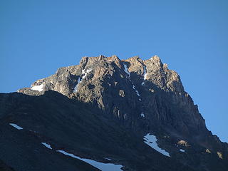
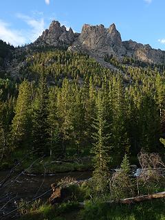
Medicine Mountain - 11,720' - North Face class 3
bears tooth - 11,915' - east ridge class 5.8
august 2017
Overview
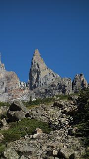
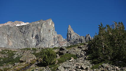
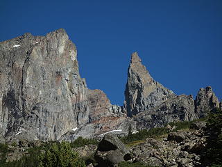
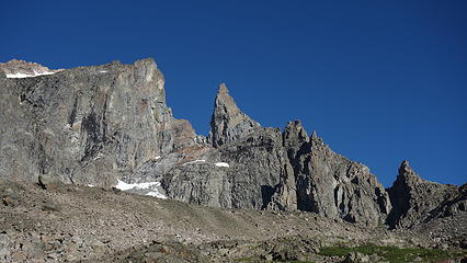
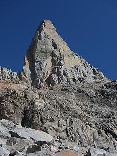
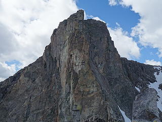
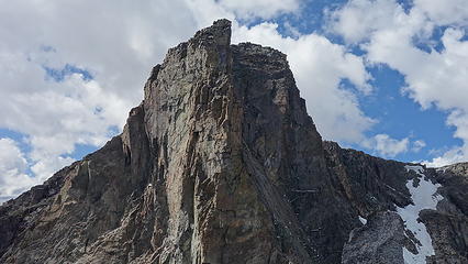
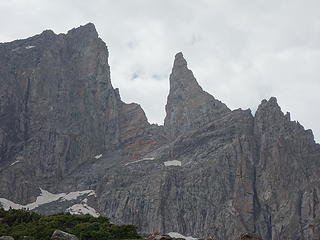
The Bears Tooth is the imposing rock spire seen from the understandably famous Beartooth Pass highway, which connects the town of Red Lodge on the east flank of the Beartooth Range with the NE entrance of Yellowstone NP. Anyone who has driven over this pass (of which nearly 20 miles of it is well above treeline) has seen the Bears Tooth, unless fog clouded the views. The feature is so appealing, the entire mountain range was named after it, which originated as an English translation from the name given to these mountains by the Crow tribe. Climbing the Bears Tooth is something the local climbers will have all done, but very few outsiders have stood on its lofty summit. Locals from Billings, Red Lodge, and a few from Bozeman consider it an enriching climb with guaranteed solitude, as the terrain calls for extensive mountain experience, and a good eye for the weather.

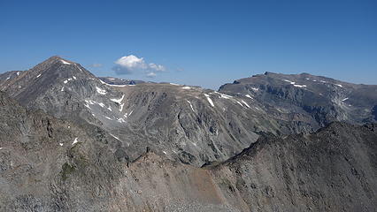
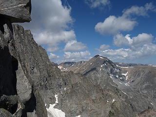
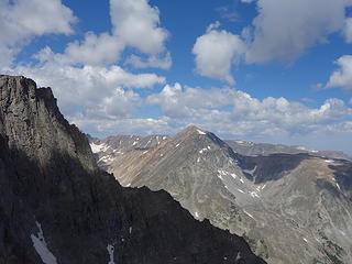
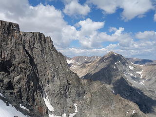
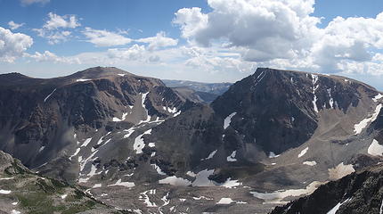
Rearguard and Forget Me Not from the summit of Bears Tooth
Getting There
There are two trailheads to choose from for approaching this tower. They are the Lake Fork, and Main Fork Rock Creek Trailheads. I quote from my Beartooth Range Area page below:
Lake Fork Rock Creek Trailhead
Access to Beartooth Mountain and the Rock Lakes
From the Montana State 308 and US Highway 212 junction in Red Lodge, go 10.8 miles west on US 212 towards Beartooth Pass and turn right onto the Lake Fork Road. Go 1.8 miles on this paved road to its end at the trailhead with ample parking. The elevation at this trailhead is 7200 feet.
Main Fork Rock Creek Trailhead
Access to the Spirit Mountain Group and Glacier Lake
From the Montana Road 308 and US Highway 212 junction in Red Lodge, go west on US 212 for 11.4 miles and turn right onto FS 2421 (Rock Creek Road) and measure from this point. Follow this paved road for 0.9 miles where it turns to dirt and passing by three National Forest campgrounds. Here the road forks, take the left fork and continue on the good dirt and pass the M-K Campground at mile 2.8. Here the road becomes rougher. Continue 8 miles on this road as it drops into Wyoming and reaches the trailhead at the Montana/Wyoming state boundary at 8,700 feet. This road is passable for tough passenger cars with good ground clearance. There are many good places to pull off and camp.

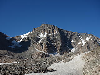
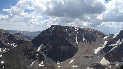
Beartooth Mountain from Bears Tooth
Approaches
Lake Fork Approach via Black Canyon Lake - 2,100 feet gain in 7.5 miles to Black Canyon Lake
It is recommended to start at the Lake Fork trailhead as the approach is much easier, with less elevation gain and much less loose talus to deal with. It is however slightly longer than the Main Fork, but this is negligible compared to the tedious nature of the Main Fork route. From the Lake Fork Trailhead, hike 5 miles up the very nice trail as it gently climbs alongside the south side of the Lake Fork of Rock Creek. At 5 miles, you will come to a large bridge where it crosses to the north side of the creek (more like a raging river). Do not cross the bridge, rather locate a trail immediately before the bridge off to the left and heading southwest. This trail starts out very nice as it weaves through open trees, but soon comes to a marshy area. Follow the now somewhat faint path through the marsh, up leftward in a small drainage, and eventually rising back into denser forest above this drainage to the right. There is a sucker trail that heads sharply right, down towards the Lake Fork partway up the small drainage. Do not follow this, but rather stay in the little creek bed. The trail will improve higher up.
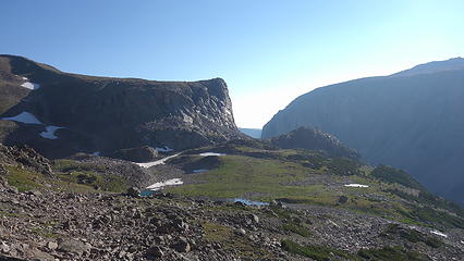
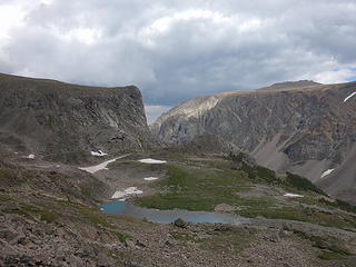
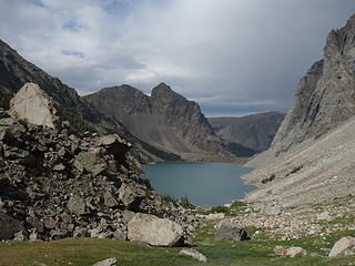
Once past this section, continue on the nicer trail as it begins to parallel a larger creek above and to its left. This is the creek that drains Black Canyon Lake. When the trees open up, do not follow the trail onto the talus slope. Instead, descend 30ish feet and cross the creek on large boulders, and continue on a fainter, but nice path through the trees and near the shore of the creek, until it disappears. Enter a small meadow and follow the grass as much as possible, angling leftward, looking for cairns to show the easiest path through the large boulders looming above. The north end of the lake is almost entirely surrounded by house sized boulders, and deviating from the path of least resistance can cost you over an hour of tedious boulder-climbing! You will reach the NE corner of Black Canyon Lake where a small grassy patch offers a nice camp spot (elevation 9,240 feet). Or, you can continue around the left (east) side of the lake for an additional mile of boulder hopping and camp at the beautiful meadow at the lakes southern shore. That would require carrying the overnight gear around the lake though, and the views wouldn't be quite as impressive.
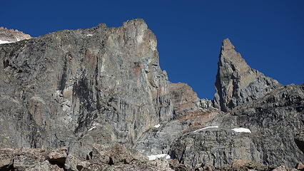
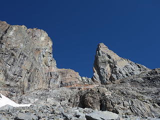
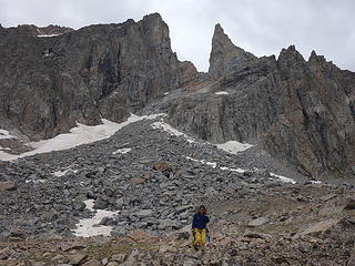
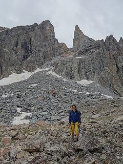
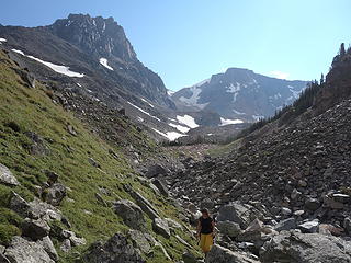
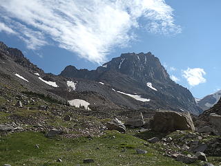
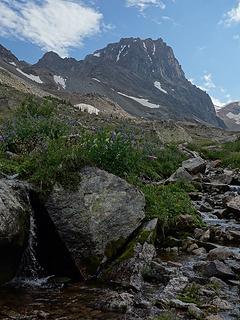
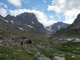
Hike up the drainage until you reach the toe of the rock glacier, and continue along the small depression on its north edge. You shouldn't have to venture too far onto the rock glacier itself, as the terrain is hideously loose. When you come to a small stream coming down from the right at about 9,800 feet, ascend the nice slopes along its left side, and pass by the 10,190 foot tarn. Continue west towards the annoying looking talus slope leading to the formidable looking col separating the Bears Tooth from the main mountain. Ascend this large talus field for 800 feet to 11,300 feet where the talus ends and the scrambling/climbing begins.
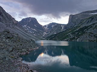
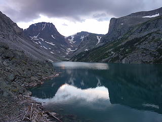
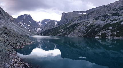
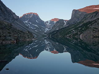
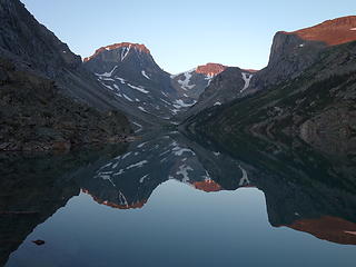
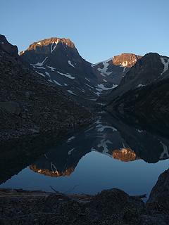
 Sunrise on Black Canyon Lake |
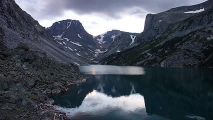
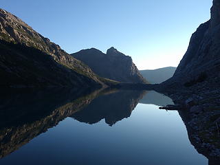
 Walking away into the sunset... |
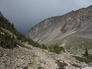
Main Fork Approach over the Spirit/Rearguard Saddle - More Elevation Gain!
This approach is a bit shorter in mileage than the one described above, but is definitely more effort, as you will need to ascend over the 11,280 foot saddle between Spirit Mountain and Mount Rearguard, then descend over 1000 feet into the large valley above Black Canyon Lake. This descent not only is covered with hideously loose talus, there is a rock glacier you'd also have to cross to get to the south facing slopes leading up towards the Bears Tooth. Then this would have to all be repeated on the return trip. If you are set on this approach however, at least do it when it's mostly snow covered, such as May-early July. From the Main Fork Trailhead, begin up the steep switch-backing trail through an old burn area and reach a nice footbridge crossing Rock Creek after 0.6 mile at 9,080 feet. Cross the bridge and continue up the trail for eight more switchbacks and locate a side trail heading off to the right (north) at 9,230 feet, a quarter mile from the bridge. There may a cairn here to mark the turnoff but don't expect one. Follow this steep but well traveled boot path along the left (west) side of this side creek for 0.35 mile to where it crosses back to the east side of the creek on large boulders at 9,600 feet. Past this crossing the slope eases and the path continues through open grass above and on the right side of the creek. The trail can be hard to follow at times but follow it to a small tarn at 9,850 feet where it once again crosses the creek back to the west side. Continue up another couple hundred feet on open grass to Shelf Lake then continue around its left (west) side and continue northward over a large, broad grassy bench for 1.2 miles to the southeast corner of Moon Lake. It's about 3.2 miles from the Rock Creek Trailhead to Moon Lake with slightly over 1,500 feet of elevation gain.
Continue around the right (east) side of Moon Lake, then up the valley towards the obvious saddle right at the base of the NE ridge of Spirit Mountain. Do not ascend to the slightly higher saddle off to the right closer to Rearguards West Ridge. Once at the saddle (which you are likely cursing if it wasn't snow covered), take in the views of the Bears Tooth directly across from you. It's 1100 feet down, which you will have to re-climb on return. Begin descending, and angle left to avoid the series of cliffs that are found below the saddle. Again, snow would make this all easier. Reach the rock glacier in the valley at 10,100 feet and traverse straight across to reach the south facing slopes leading towards the Bears Tooth/Beartooth Mountain Col. Ascend the nice, talus-free slopes for 500 feet, passing off to the left (west) of the 10,190 foot tarn, then continue up large talus for an additional 800 feet, where the talus ends at 11,300 feet directly below the formidable looking col separating the Bears Tooth from the main mountain. Here the scrambling and climbing begins.

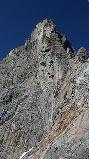
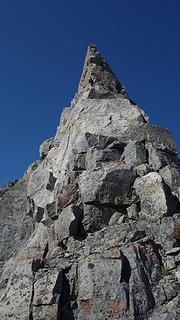
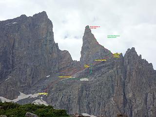
East Ridge Standard Route - 5.8
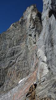
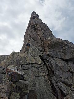
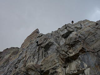
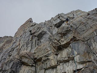
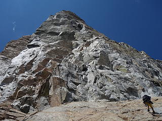
From the end of talus at 11,300 feet, it is only another 600 feet to the summit, but plan for at least 4 hours to ascend and return this distance. The climb begins by scrambling Class 3 ledges upwards, trending rightward to connect series of rubble covered ledges and crossing right at the base of the vertical south face to reach the angled east ridge. There is one section that is quite scary and unprotected, where the ledges somewhat disappear, leaving you to traverse on a somewhat dust covered friction slab for a handful of moves with deathly exposure below. Once across this, the large ledge at the base of the south face widens considerably and it's an easy romp to the east ridge. Take solace as you won't have to return across that spot, as there is an established rappel anchor that allows you to bypass this on return. A 6 foot Class 4 move is required to actually mount the ridge, where you can then rope/rack up. Note that for the route description below, the pitches are 30 meters long.
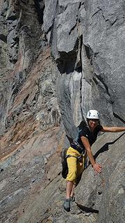
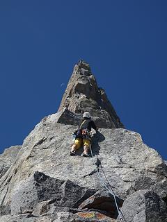
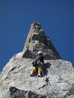
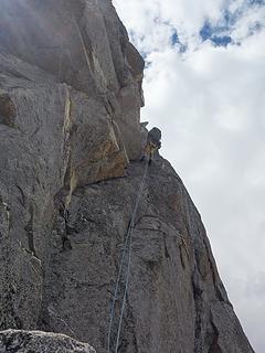
 Elaine making part of the scary traverse |
 Passing the scary traverse |
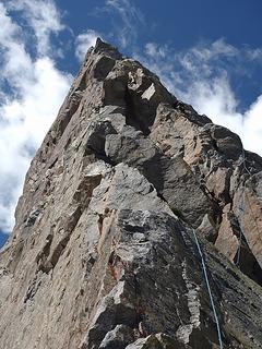
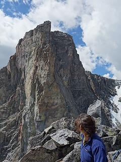
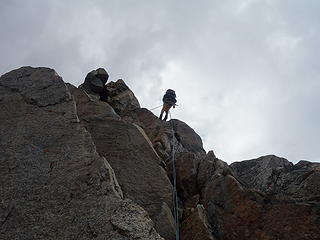
 Looking up the east ridge |
Pitch 1 & 2 - The first two pitches are largely a Class 3-4 scramble with a few low 5th class spots mixed in. One 20 foot slab with 5.4 climbing was a little spice to get you warmed up. Rope drag will be an issue. There are slung boulders abound to use as anchors. Nothing too crazy here.
Pitch 3 - When the ridge steepens, ascend a chimney for 30 feet or so, exit right and continue up the featured face to a nice anchor on a large ledge. Class 5.6
Pitch 4 & 5 - *Money Pitches* Climb up the wildly exposed arete just above the ledge (Class 5.6), and continue up easier blocky rock to a smaller ledge with anchor. Looking above from here you will see a large overhang. Continue around to the right and climb a right facing lieback hand-crack dihedral (Class 5.8) that bypasses this overhang to the right. The dihederal more or less transitions into an awkward right facing chimney but face holds and jugs are easy to come by (Class 5.7). This section may be damp, as you are now on the colder north side of the tower. The final 30 feet to the summit eases to 5.4
Enjoy the incredible views from the top!
 Another look across the scary traverse Another look across the scary traverse |
 Looking up the east ridge |
 Elaine on the lower east ridge |
 Rappelling off the east ridge Rappelling off the east ridge |
 View of the lieback dihedral crux |
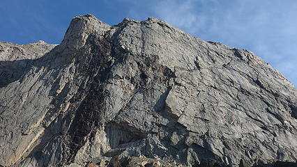
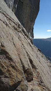
 Looking up the imposing south face |
 Descending the talus apron |

Camping/Red Tape
Camping can be found at either end of Black Canyon Lake, Lost Lake, Shelf Lake, Moon Lake, or the small tarn just below Bears Tooth. No red tape!

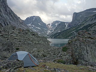
Camping at Black Canyon Lake
When to Climb
The Bears Tooth has been done in winter. It took a combined effort including 20 failed attempts over many years, but on March 16th, 2010, Rusty Willis and Loren Rausch finally topped out on the summit in calendar winter. The effort capped off a nearly 20 year goal, of which almost killed them at one point. The approach was done on skis, and many pitches were added, as they linked up the entire ridge extending off to the east beyond the typical start for the ascent in summer. This was done to avoid dangerous avalanche terrain on the slabs below the south face. 15 total pitches up to 5.8 rock and mixed climbing to grade 5 were done. See the report here!
For mere mortals, June-September is the typical time to climb, with July and August bringing the most thunderstorms to be aware of. Start early!

Bears Tooth in winter. Photo by Rusty Willis
Trip report
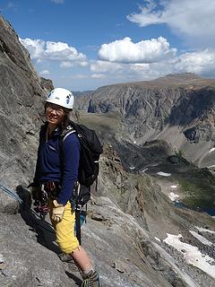
Elaine joined me for a trip back to the Beartooths where we were hoping to climb a variety of technical routes, including the Bears Tooth, Castle Rock Spire, Pensive Tower, Lunar Arete and the North Face of Glacier Peak. All these routes were ones I still need to do, in order to provide good first hand beta for my Montana 12ers guidebook still in the works. Due to two days of constant rain in the beginning of the trip however, we only hit two of those objectives. They were the Bears Tooth and the North Face of Glacier Peak, which so happened to be my final Montana 12er I had yet to summit. As an aside, for more information about the Bears Tooth and the standard route up, see this page.
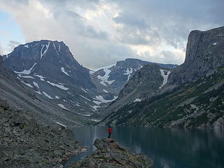
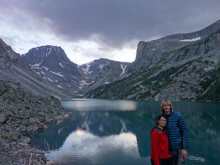
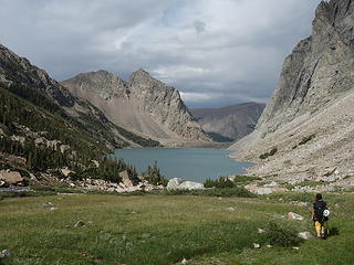
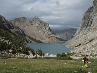
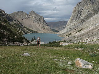
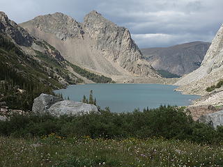
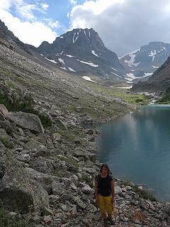
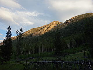
After enduring two wet, miserable days of cold, windy rain soaked days in the upper west fork of Rock Creek basin near Omega Pass (details regarding that will have to come in another story), we hiked up the Lake Fork Trail and made the approach to the beautiful Black Canyon Lake. Believe it or not, it was still off and on raining as we hiked the easy 7 miles to the north end of the lake. I had been here once before back in 2012 with Stephan, but not since then. I remember this lake being exceptionally gorgeous and the second time around was just as amazing as the first. Elaine was particularly impressed, as there are no mountains in Canada that look quite like the Beartooths. We set up camp on a small grassy patch at the north end of the lake, as we didn't want to haul the packs around the mile long lake, where much of it is large boulder hopping (story of the Beartooth Range!)
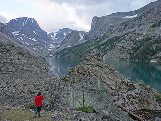
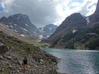
The afternoon sun was perfect on the towering cliffs that guard the lake on both sides. We took some nice photos as the lake water calmed to a glassy appearance, and the last of the clouds drifted past, occasionally clouding the summit area of Spirit Mountain seen at the head of the large valley. We had a nice, dry nights rest before waking a bit before sunrise to start the traverse around the lake.

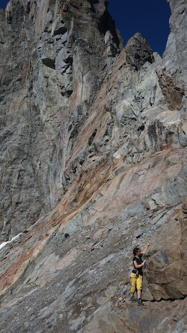
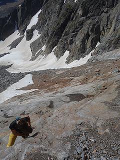
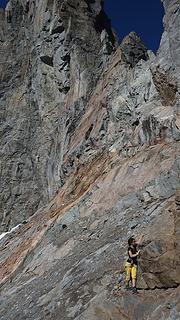
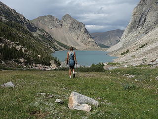
We made good time traversing around the left side of the lake and made it to the large meadow on the south side, before boulder hopping once again commenced. We actually ascended on talus more or less the entire way up to the start of the route up Bears Tooth. It was a long way up the large boulders, but we eventually made it to the top of the talus apron at 11,300 feet. From here the scrambling began. We made our way up 200 or so feet of kitty litter covered ledges in the Class 4 variety before beginning a rightward traverse. We located where the base of the vertical south face met the ledges and slabs and aimed for that spot.
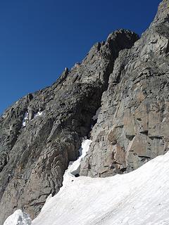
There is a 15 foot horizontal traverse where the ledges disappear, and we had to friction traverse on dusty steeper slab with little in the way of features or protection. This was a scary spot as a fall would have had us sliding down the cliffs below. Luckily I was able to utilize a couple good hand holds on the steep wall of the south face to safely cross. Elaine and I both put our rock shoes on just for this part, but I then returned to my hiking shoes for the next easy ledge walk. We made a 6 foot Class 4 mantle move to mount the east ridge proper and we had a nice rest on the flat portion of the ridge. Here we racked up and had a snack.
Elaine took the first of two very easy pitches (low 5th class in a few spots). Rope drag was an issue so we had to only do 30 meter lengths. We didn't hit much 5th class at all the first part of the ridge as it was so low angle. For our third pitch, Elaine led up a steeper chimney, then exited it to the right and climbed a steep, edgy face to a nice ledge (5.6). I then did a full 60 meter pitch climbing through the best part of the route, which involved a sustained 5.8 lie back hand-crack dihedral. This was located to the right of the overhang in the upper ridge. The dihedral then turned into a right facing awkward, damp 5.7 chimney, then eased off to the summit. I was elated to finally be standing on this iconic gem of a peak few people ever get the chance to experience.

Since the clouds were building, we only stayed on the top for 20 minutes before starting to rappel down. We made 6 single rope rappels, plus another 2 to bypass the scary traverse before we could scramble back to the talus apron, then return the long hike back around the lake to our camp. We were hit with intermittent hail but nothing serious. Off to the east we did see a storm hot the Red Lodge area though. Upon reaching the tent, we raced the hike back out to the trailhead and made it back to Red Lodge just in time to catch dinner at Mas Taco before their 9pm close time! A perfect day was complete 

PS...if you ever find yourself in Red Lodge, BE SURE you eat at Mas Taco. By far the best place to eat in town!
Stay tuned for part 2 of this trip report where Elaine and I accidentally made a first ascent on the north face of Glacier Peak, which also was my last Montana 12er!!!