LEMKE CLIMBS
  • About
    • Whats New
    • 2019 Goals/Wishlist
    • Contact
  • Washington
    • North Cascades >
      • Sahale Peak, Boston Peak
      • Eldorado Peak, Klawatti Peak
      • Black Peak
      • Forbidden Peak West Ridge
      • Primus Peak Attempt
      • Big Snagtooth
      • Liberty Bell Beckey Route
      • Burgundy Spire North Face 5.8
      • Ragged Ridge - Katsuk, Kimtah and Cosho Peaks
      • Colfax Peak
      • South Early Winters Spire via SW Buttress
      • Chilliwack Mini-Slam
      • Mesahchie Peak
      • Inspiration Traverse
      • Mount Shuksan Ski
      • Full Pickets Traverse
      • Mount Goode NE Buttress & Storm King
      • Mount Baker North Ridge WI3
      • Snowfield Peak
      • Lincoln Peak
      • Silver Star Mountain
      • Mount Buckner & Horseshoe Peak
      • Azurite Peak
      • Tower Mountain & Golden Horn
      • Mount Logan
      • Custer Ridge & Easy Mox
      • Mazama Dome
      • Sherman Peak
      • Mount Ballard
      • Southern Pickets Traverse
      • Corteo Peak
      • Whatcom Peak
      • Castle Peak
    • Glacier Peak Wilderness >
      • Buck Creek Pass, Cloudy Peak, Spider Gap
      • Dome Peak, Spire Point
      • Mt. Maude and Seven Fingered Jack
      • Mount Formidable NE Face 5.6 Second Ascent
      • Dumbell and Greenwood Mountains
      • Glacier Peak Wilderness Mountain Massacre
      • Clark and Luahna Peaks
      • Sinister Peak
      • Chiwawa Mountain
      • Tupshin & Devore Peaks
      • Buck & Fortress Mountains
      • Glacier Peak
      • Snowking Mountain
    • Olympic Peninsula >
      • Buckhorn Mountain
      • Flapjack Lakes Hike
      • Grey Wolf Peak, High Divide Trail
      • Mount Ellinor
      • Mount Constance West Arete
      • Mount Olympus
    • Alpine Lakes Wilderness >
      • Chikamin Peak
      • PCT - Snoqualmie to Pete Lake
      • Necklace and Tank Lakes
      • Enchantments Day Hike
      • Granite Mountain (Snoqualmie)
      • Colchuck Peak
      • Cannon, Enchantment and Stuart
      • Ingalls Peaks
      • McClellan Peak
      • Dragontail Peak
      • Web Mountain
      • Mount Index Attempt
      • Snow Creek Wall Orbit 5.8+
      • The Tooth South Face
      • Eightmile Mountain
      • Argonaut Peak NE Couloir
      • Little Annapurna South Face 5.5
      • Snow Creek Wall Outer Space 5.9
      • Cashmere Mountain
      • Sherpa Peak North Ridge 5.8
      • Chair Peak NE Ridge
      • Lichtenburg Mountain
      • Mount Index
      • McClellan Butte
      • Chimney Rock
      • Alpine Lakes High Route
    • Pasayten Wilderness >
      • The Craggies
      • Tiffany Mountain
      • Pasayten Mini-Slam
      • Remmel Group
      • Jack Mountain
      • Robinson Mountain
      • Monument Peak Group
    • Mountain Loop Highway >
      • Vesper Peak
      • Mount Dickerman
      • Sloan Peak West Face 5.8
      • Mount Forgotten
      • Whitehorse Mountain
      • Gothic Peak
    • Lake Chelan Sawtooth Wilderness >
      • Star, Courtney, and Grey Peaks
      • Hoodoo Peak and Raven Ridge
      • Abernathy Peak
      • Mount Bigelow
      • Reynolds Peak
      • Oval Peak
      • Gardner Peaks
      • Chelan Sawtooth Trio
    • Southern WA >
      • Mount Adams
      • Mount Rainier - Emmons Route
      • Mount Saint Helens
      • Goat Peak
      • Lane Peak, Plummer Peak (Tatoosh)
      • The Unicorn (Tatoosh)
      • Little Tahoma
      • Liberty Cap
    • WA Rock and Ice Cragging >
      • Index Town Walls
      • Vantage
      • Mount Erie
      • Exit 38
      • Leavenworth
  • Colorado
    • San Juan Mountains >
      • Mount Sneffels Lavender Snow Climb
      • Uncompahgre, Matterhorn Peaks
      • Redcloud, Sunshine Peaks
      • San Luis Peak
      • Vermilion, Fuller Peaks
      • Stewart Peak, Baldy Alto
      • Jones, Niagara, American Peaks
      • Wetterhorn Peak, Handies Peak
      • Wilson Group
      • Arrow Peak
      • Mount Sneffels SW Ridge
      • Jagged Mountain, Chicago Basin
      • Teakettle Mountain
      • Dallas Peak
      • Vestal Peak Wham Ridge, Greystone Peak
      • Organ Mountain
      • Phoenix Peak
      • Half Peak
      • Point 13832 Group
      • Golden Horn
      • Mount Sneffels Snake Couloir
      • Pigeon, Turret Peaks
      • Trinity Peaks
    • Elk Mountains >
      • Four Pass Loop
      • Castle, Conundrum Peaks
      • Snowmass Mountain
      • Cathedral Peak
      • South Maroon Peak
      • The Pyramids
      • North Maroon Peak, Sleeping Sexton
      • Capitol Peak, Mount Daly
      • Malemute Peak
      • Hagerman Peak
    • Sangre de Cristo Mountains >
      • Blanca Peak, Ellingwood Point
      • Challenger Point
      • Mount Adams
      • Spread Eagle Peak
      • Humboldt, Obstruction, Columbia Peaks
      • Mount Lindsey, Huerfano Peak
      • Little Bear Peak
      • Crestone Needle Ellingwood Arete
      • California Peak
      • Crestone Peak North Buttress
      • Operation Dark Snake
      • Kit Carson Mountain
    • Sawatch Mountains >
      • Iowa Peak
      • Point 13,618 - Hunky Dory Lake
      • Gold Dust Peak, Notch Mountain
      • Mount Jackson
      • Mount Belford
      • Shavano, Tabeguache Peaks
      • Mount Antero, Cronin Peak
      • Twining Peak
      • Mount Massive
      • Casco Peak
      • Mount Huron
      • Mount Elbert
      • Mount Oxford
      • Mount Hope
      • Mount Yale
      • Lackawanna Peak
      • Mount Columbia
      • La Plata Peak
      • Rinker and Twin Peaks
      • Bull Hill, Mount Princeton
      • Missouri Mountain
      • Mount Oklahoma
      • French Mountain
      • Mount Ouray
      • Grizzly A, Garfield Peaks
      • Mount Harvard
      • The Three Apostles
      • Emerald Peak
      • Holy Cross
      • Mount Aetna
      • Deer Mountain
    • Greater Park Range >
      • Kneeknocker Pass, Piney Lake
      • Drift Peak
      • Sherman Peak, Dyer Peak
      • Gore Range Traverse
      • Quandary Peak
      • Pacific, Atlantic Peaks
      • Clark Peak
      • Crystal Peak, Peak 10
      • Fletcher Mountain
      • The DeCaLiBron
      • Loveland Mountain
      • The Mosquito Traverse
      • Mount Arkansas
      • Clinton Group
      • Eagles Nest, Peak C
      • North Star Mountain
      • Peak X
      • Wheeler Mountain
    • Front Range >
      • Mount Evans, Spalding
      • Mount Bierstadt
      • Mount Parnassus, Bard Peak
      • Cupid, Sniktau, Grizzly D Peaks
      • James Peak
      • Mount Silverheels
      • Grays and Torreys Peaks
      • Mount Edwards
      • Mount Flora, Longs Peak
      • Square Top Mountain
      • Petit Grepon South Face 5.8
      • Mount Meeker Dreamweaver Couloir
      • Santa Fe Peak
      • The Citadel & Pettingell
    • Colorado Ice Climbing >
      • Lincoln Ice Falls
      • Ouray Ice Park
      • Avocado Gully and The Drool
      • Hidden Falls
    • Colorado Rock Climbing >
      • Eldorado Canyon
      • The Flatirons
      • North Table Mountain
      • Colorado National Monument >
        • Independence Monument
  • Wyoming
    • Wind River Mountains >
      • Gone With the Winds
      • Union Peak - Solar Eclipse
      • Wind River Peak
      • Wind River Slam
    • Teton Range >
      • Grand Teton Owen Spalding 5.4
      • Mount Owen Attempt
    • Wyoming Absarokas and Gros Ventre Range >
      • Jackson Peak
      • Francs Peak
    • Yellowstone National Park >
      • Top Notch Peak
    • Bighorn Range and Great Divide Basin >
      • Boars Tusk
      • Loaf Mountain
      • Cloud Peak
      • Black Tooth Mountain
    • Devils Tower
    • Cody Rock and Ice Climbing
  • Montana
    • Beartooth Mountains >
      • Whitetail Peak Group
      • Beartooth Mountain
      • Spirit Mountain Group
      • Mount Peal
      • Granite Peak Group
      • Castle Rock Group
      • Castle Mountain NE Couloir
      • Mount Inabnit and Sylvan Peak
      • Mount Hague South Slopes
      • Mount Villard and The Granite Peaks Traverse - 5.4
      • Spirit Mountain NE Ridge - 5.4
      • California Ice WI 4
      • The Ramp 5.8
      • Linea Alba 5.10d
      • Iceberg Peak
      • Metcalf Mountain North Rib 5.8
      • Villard Spires HP West Ramp
      • Cairn Mountain
      • Snowbank Mountain
      • Mount Wood Group
      • Bears Tooth
      • Glacier Peak Catch-a-Sunrise FA
    • Southwest Montana Ranges >
      • Madison Range >
        • Koch Peak
        • Sphinx Mountain
        • Beehive Peak
        • South Sheep Mountain
      • Gallatin Range
      • Bridger Range >
        • Sacajawea Peak
        • Saddle Peak
        • Baldy Mountain
        • Ross Peak
      • Montana Absorakas >
        • Arrow Peak
        • Black Mountain
        • Mount Cowen
      • Tobacco Root Mountains >
        • Hollowtop Mountain
        • Belle Point
        • Noble Peak
        • Leggat Mountain
      • Crazy Mountains >
        • Crazy Peak
    • Glacier National Park >
      • A Taste of Glacier National Park
      • Divide Mountain
    • MT Rock and Ice Climbing
  • Utah
    • Uinta Mountains >
      • Kings-Emmons Ridge Run
      • Hayden Peak
      • Iron Hayden Wall Rock Climbing
    • Wasatch Range >
      • The Sundial Eleventh Hour 5.8
      • Mount Timpanogos
    • San Rafael Swell >
      • Ramp, Cistern Canyons
      • Salt Wash, Black Mountain, Moroni Slopes
      • Ding, Dang Canyons
      • Little Wild Horse, Bell Canyons
      • Quandary Canyon
      • San Rafael Knob
      • Miners Hollow (Knotted Rope Canyon)
      • Temple Mountain
      • Chimney Rock
      • Bottleneck Mesa
      • Window Blind Peak
      • Lower Baptist Draw & Upper Chute Canyon
    • Capitol Reef National Park >
      • Cathedral Valley Tour
      • Sheets Gulch
      • Halls Creek Narrows
      • Brimhall Canyon and Strike Valley Overlook
      • George Benchmark
    • Moab Area, Canyonlands, Arches >
      • Maze District
      • Needles District
      • Maze District
      • White Rim Trail Biking
      • Elephant Butte, Bullwinkle Tower and Lizard Rock
      • South Six Shooter
      • Elephant Canyon
      • Parriott Mesa
      • Ancient Art
      • Castleton Tower North Chimney 5.8
      • Klondike Bluffs
      • Mount Peale & Tukuhnikivatz
    • Robbers Roost Country >
      • Horseshoe Canyon, Goblin Valley
      • Bluejohn Canyon
      • Happy Canyon Narrows
      • Shenanigans, Leprechaun Slots
      • Larry Canyon
      • Merry Piglet Slot
      • Lower Maidenwater Canyon, Turkey Knob
      • Morocco Canyon
      • Monkey Business Slot
      • Hog Canyon Slots
      • Upper Maidenwater Canyon Slots
      • Mount Ellen
      • Buck Canyon
      • Point 4906
      • Alcatraz Canyon
      • Hard Day Harvey Slot
      • Mount Ellsworth
      • Good Day Jim Canyon
      • White Roost Canyon
      • Upper Stair Canyon
      • Dragon Canyon
    • Escalante National Monument >
      • Phipps Canyon and Arch
      • Red Breaks Slot
      • Dry Fork Slots, Coyote Gulch
      • Little Death Hollow/Wolverine Canyons
      • Egypt 3 Slot
      • Egypt 1 Canyon
    • Zion/Bryce >
      • Ataxia Tower Ashtar Command 5.9
      • Mount Kinesava Cowboy Ridge
      • Birch Hollow
      • Aires Butte
      • West Temple
      • Mystery Canyon
      • Crazy Streak
    • Cedar Mesa Region/Valley of the Gods >
      • Eagle Plume Tower Eagle Feather 5.10b
  • California
    • High Sierras, Southern CA Ranges >
      • Telescope Peak, Manly Beacon
      • Tahquitz Rock Whodunit 5.9
      • Tahquitz Rock Long Route 5.9
      • Palisade Traverse
      • White Mountain
    • Yosemite National Park, Central CA
    • Northern CA Cascades >
      • Lava Beds National Monument
      • Mount Shasta
  • Oregon
    • Oregon Volcanoes >
      • Three Fingered Jack
      • Mount Scott
    • Blue Mountains >
      • Twin Peaks
    • Trout Creek Rock Climbing
  • Alaska
    • Eagle Peak and Mount Ewe
    • Jatt Peak and Portage Pass
    • Rainbow Peak
    • Mount Brooks Attempt
    • Arrigetch Peaks Trek
    • Ab Mountain Hike
    • South Suicide Peak
    • Mount Hunter West Ridge Attempt
    • Cantata Peak Attempt
    • East Twin Peak
    • Mount Alice
    • Crow Pass and Hope Point Hikes
    • Indianhouse Mountain Attempt
    • Lynx Peak
    • Harding Icefield Hike
    • Hatcher Pass and Grapefruit Rocks Climbing
    • Mount Sanford
    • Mount Hunter West Ridge
    • Mount Fairweather
  • Nevada
    • Ginger Cracks 5.8
    • Mescalito Dark Shadows 5.8
    • Birdland and Olive Oil
    • Frogland 5.8
    • Johnny Vegas 5.8
    • Schaeffer's Delight & Triassic Sands
    • Solar Slab - 5.6
  • British Columbia
    • Mount Matier
    • Taiya Peak
    • Bugaboo Spire NE Ridge
    • Mount Sabine Easy Honey 5.10b
    • Mount Sir Donald NW Ridge Attempt
    • Black Tusk
    • Slesse Mountain NE Buttress
    • Warden Peak
    • Triple Peak
    • Gimli Peak
    • Mount Waddington
  • Alberta
    • Mist Ridge Hike
    • Mount Temple Attempt
    • East Wendell Peak
    • Loder Peak
    • Tower Mountain Attempt
    • The Rimwall
    • Mount Yamnuska Directissima 5.9
    • Mount Lawrence Grassi
    • Mount Lorette
    • Roche A Perdrix
    • Mount Edith Cavell East Ridge 5.3
    • Mount Louis Kain Route
    • Eiffel Peak
    • Mount Alberta
    • Canadian Rockies Ice Climbing
  • Other States
    • Arizona >
      • Grand Canyon Bright Angel Trail
      • Beanfest at Cochise Stronghold
      • Baboquivari Peak
      • Humphreys Peak
    • New Mexico >
      • Philmont Trek August 2008
    • Yukon >
      • Canyon Peak
  • International
    • Mexico & Central America >
      • Mexico - Pico de Orizaba, Izta
      • Guatemala Volcanoes
    • South America >
      • Chile >
        • An Introduction to Patagonia
        • Exploring Pucon and Lanin Volcano
        • Cerro Puntado & Palo
        • Cerro Colorado
        • Cerro Puno & Agudo
        • Cerro Trinidad Attempt
        • Volcan Quetrupillan
        • Cerro Placas
        • Volcan Puyehue
        • Cerro Conico
        • Cerro Barros Arana
        • Cerro Cordillerano
        • Ojos del Salado
      • Argentina >
        • Nahuel Huapi National Park & The Frey
        • Cerro Helio Azul & Tronador Attempt
        • Aguja Guillaumet Amy Couloir
        • Nevado de Acay
        • Chiaro de Luna
      • Peru >
        • Cordillera Blanca - Tocllaraju and Urus
        • Cordillera Blanca - Ishinca Peak and Artesonraju
        • Cordillera Blanca - Quitaraju & Alpamayo
        • Exploring Southern Peru
      • Bolivia >
        • Pequeno Alpamayo
        • Huayna Potosi
        • Illimani
    • Oceania >
      • Exploring New Zealand's South Island
      • Puncak Jaya
      • Mount McPherson and Talbot
      • Single Cone
      • Mount Cook
      • Mount Aspiring
      • Manakau
      • Mount Wilhelm
    • Central Asia >
      • Kyrgyzstan 2021
    • Europe >
      • Iceland & Faroe >
        • Snaefellsjokull
        • Kaldbakur
        • Slaettaratindur
  • Sorted by Year
    • 2008 Trip Reports
    • 2009 Trip Reports
    • 2010 Trip Reports
    • 2011 Trip Reports
    • 2012 Trip Reports
    • 2013 Trip Reports
    • 2014 Trip Reports
    • 2015 Trip Reports
    • 2016 Trip Reports
    • 2017 Trip Reports
    • 2018 Trip Reports
    • 2019 Trip Reports
    • 2020 Trip Reports
    • 2021 Trip Reports
    • 2022 Trip Reports
    • 2023 Trip Reports
  • Vanlife
    • Conversion Journal >
      • Floor Installation
      • Folding Bed
      • Coffee Table
      • Thinsulate Installation
      • The Couch
      • The Wardrobe
      • Bookshelf
      • Water System
      • Electrical System
      • The Pantry
      • Refrigerator
      • Tire Upgrade
      • Heating System
      • Composting Toilet
LEMKE CLIMBS

illimani

Illimani - 21122' - West Ridge
also includes Isla del Sol, Colca canyon, & little cusco
​April 2018

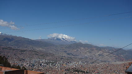
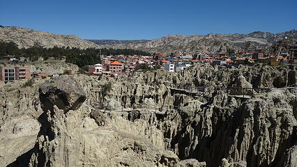
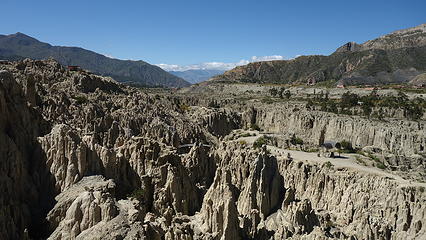
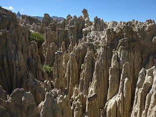
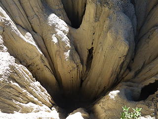
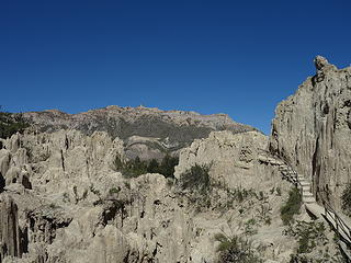
Going back now to April 2018, Illimani would be the last big mountain objective Elaine and I would embark on during our 4 months in South America last year. After successfully ascending Pequenyo Alpamayo and Huayna Potosi in the preceding couple weeks, we were finally acclimated enough for Illimani, which sits at at elevation of 6438 meters, which sits just 104 meters lower than Sajama, the highest mountain in Bolivia in a completely different part of the country. Illimani is so special though because it towers so brilliantly above the capitol city of La Paz, and we would see its grandeur every day while exploring around the city. During one of our rest days after Huayna Potosi, I decided to head off with a couple new friends we made from our hostel to Valle de La Luna, which is a small canyon with a maze of deep chasms and hoodoos sitting right next to a nicer neighborhood just south of the La Paz city center. A quick collectivo ride and we were there, and we enjoyed a scenic walk exploring the interesting landforms. 

Illimani towers above La Paz
Valle de La Luna
Valle de La Luna
Many hoodoos
Many hoodoos
 
Deep chasms
Deep chasms


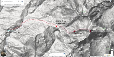
That evening we inquired about how to get to Estancia Una, the tiny village at the base of Illimani about 15 kilometers to the west of the summit of Illimani. We were informed by the guiding agencies that you can take a bus (collectivo) from the area where the market is located near Plaza Marcelo to Estancia Una but it left at some time between 4-6am (super helpful lol). With the agencies charging over $100 each way from La Paz to Estancia Una, we opted to try and find the bus early the next morning. So we ran around Av. Illampu buying all the food we would need for 4-5 days and packing up in our hostel (which was located right at the intersection of Av Illampu and Sagarnaga). We tried to get some sleep but my excitement was too high. 

At 3am we woke and ate a quick breakfast before saddling up our packs and heading out to roam the streets of La Paz in the wee hours of night. Perhaps this was only ok since I am so much bigger than Bolivians, however we never encountered any sketchy individuals. Our bigger problem was we continued to roam and roam around asking whoever we saw who was up if they knew where the bus to Pinaya was and as in traditional South American fashion, everyone had a completely different answer! We circled around Plaza Mercelo probably 4 times going to all these different intersections we were directed to go with no luck. As 5:30am rolled past, we were about to give up when by total chance, I saw a collectivo van parked in a small spot just off the road (unfortunately this exact location escapes me) and I went to ask the driver if they were headed to Pinaya and lo and behold he was! He was planning to leave around 6am so we hopped in and secured a couple seats. His price was somewhere around 50 Bolivianos. 

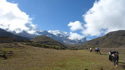
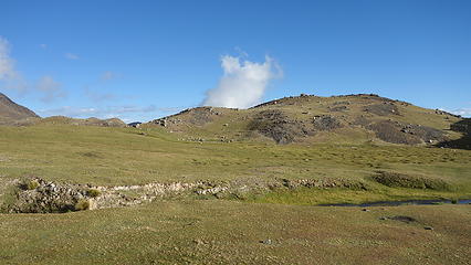
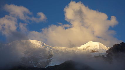
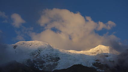
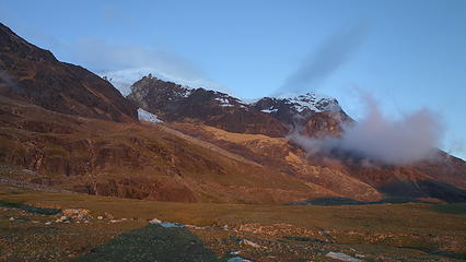
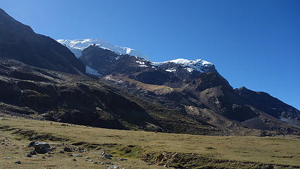
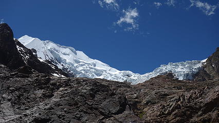
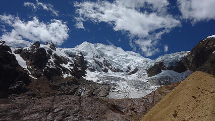
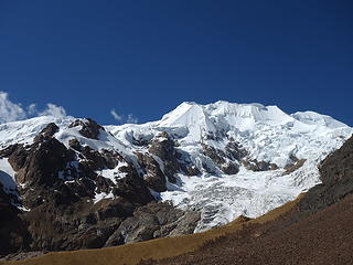
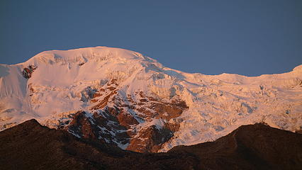
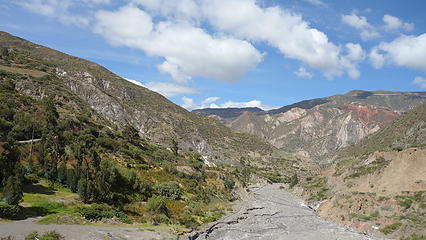
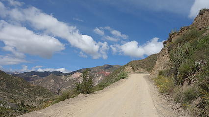
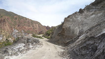
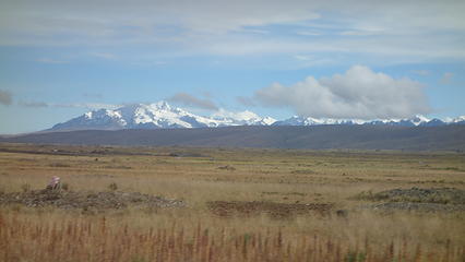
The ride over was very scenic, as we were on dirt roads as soon as we left the city proper, which ascended up and over 3 large ridges and contoured above some big valleys. We passed through the town of Palca which was a somewhat larger village about 1 hour from La Paz and continued eastward on at times very narrow and heavily switchbacked roads. People would get off in tiny villages along the way until Elaine and I were the last ones in the van. The driver mentioned he doesn't see travelers often, and was surprised we were taking a collectivo to access Illimani. Upon arriving in Estancio Una at 3620 meters (same elevation as downtown La Paz believe it or not!), there was no one around, but the view of Illimani now towering directly above us was awe inspiring. The glacier clad slopes were massive. The "central" part of this village was merely a small field where the van dropped us off, circled by about 10 small dwellings. There were some kids playing around and when they noticed us with our large packs I think they notified some of the farmsmen with burros because after about 20 minutes a couple guys came up and asked if we wanted burros. We agreed to take the burros to carry our gear to the base camp which is the very large open field called Puente Roto at an elevation of 4450 meters. 

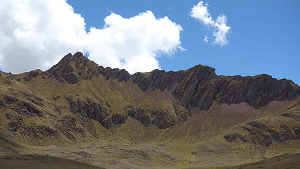
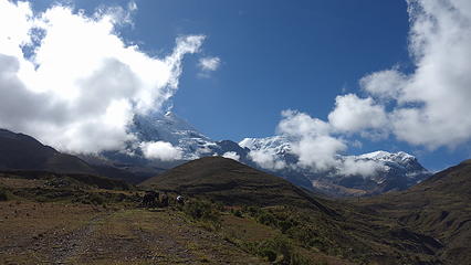
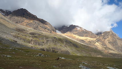
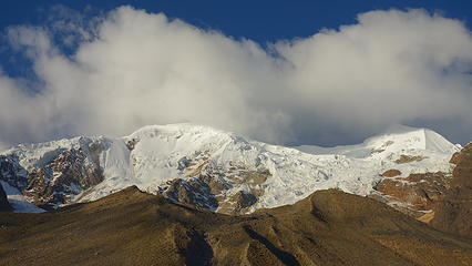
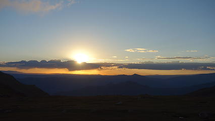
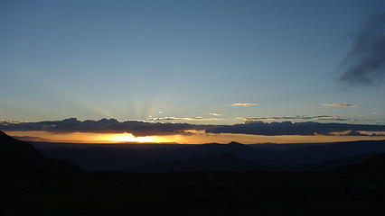
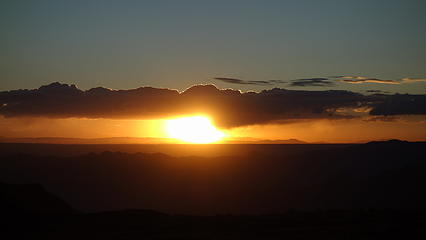
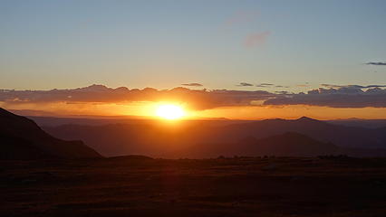
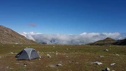
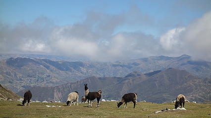
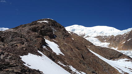
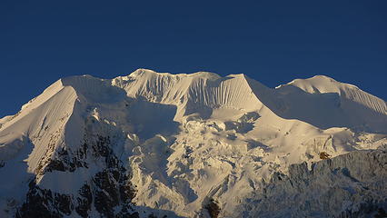
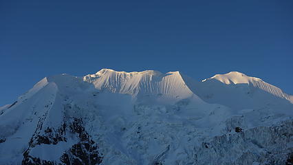
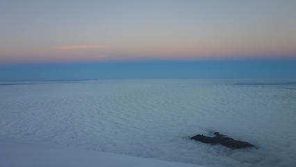
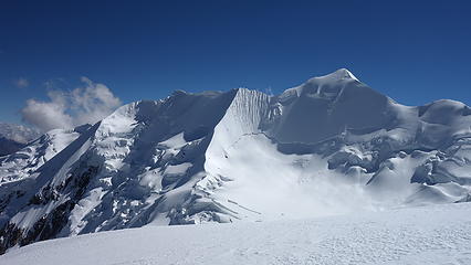
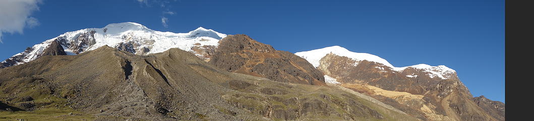
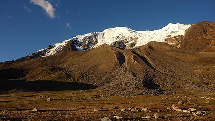
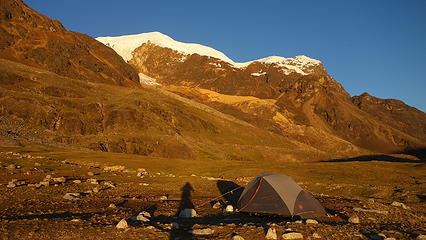
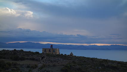
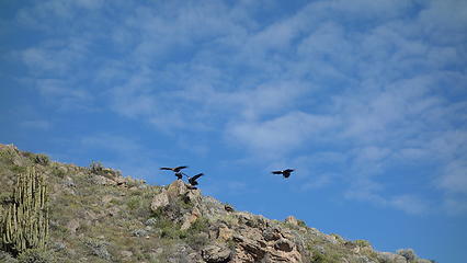
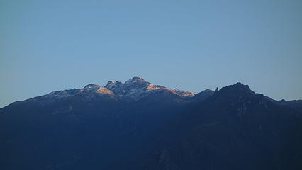
The burros were a bit more expensive than we had anticipated, even for just a one way trip ( I think we each paid $25) but to not have to carry 40-50 pounds of gear for the first 800 meters gain would be really nice. So we were loaded up and started up the dirt roads towards Illimani. As we walked through the grazing fields rich with grasses and plants perfect for the various animals the local people raised, Illimani began to show herself more, until at which point after a few hours of walking we arrived at base camp. It's a gigantic field about 400 meters by 600 meters in size. You could quite literally put up 1000 tents! Amazingly, we were the ONLY ones there likely attributed to the fact that April is early season for climbing in the Cordillera Real. With the pretty crazy weather La Paz endured during our 3 weeks visiting the area it was lucky we got good weather for all our summit days. Anyhow, we made up camp and by about 2pm we were relaxing with the sheep and llamas without any other soul around. As the afternoon lighting began to graze the west face of Illimani I couldn't help but take a ton of photos, and also scouted the route up the mountain, which followed the obvious central of 3 west ridges all the way up to the summit ridge. Directly above base camp is the start of the northern of the 3 west ridges which takes you to the lower north summit of Illimani, and while the furthest south of the three west ridges does also lead right to the true summit, it is considerably more technical. 

The sun continued to set and we made a filling dinner, as the next day we agreed would likely be the most taxing, as we would have to carry our 40 pound packs up the lower half of the central west ridge, a gain of 1000 meters to a small camp at 5400 meters, which would mark the highest either of us will have ever slept. 

Hiking through grazelands with our burros
Illimani mostly clear above
Some passing clouds in early afternoon at base camp
Lower slopes of Illimani right above base camp
Clearing later in the afternoon
West face of Illimani from base camp
Completely clear; summit is the one on the right
Sunset from the tent
 
Last light on Illimani


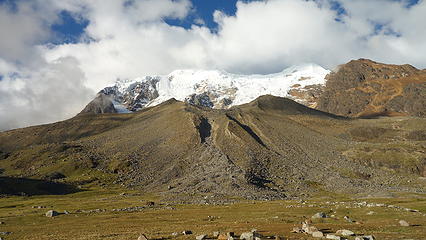
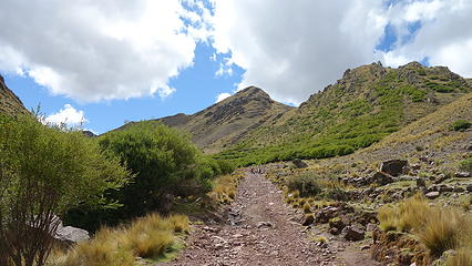
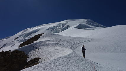
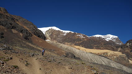
The next morning we started hiking the fairly well worn trail towards the base of the central west ridge. The trail ascended gradually and crossed the outwash basin between the northern and central ridges, which had a sizable stream coming down. It was pretty easy getting to the base of the ridge, as the trail followed nice switchbacks up to a small saddle just east of a small rounded knob. Once we crested the ridge, we saw a team of 3 coming down from above. We rested at the ridgecrest awhile until they met up with us, one of which was the guide for the other two. We chatted for a bit about conditions and they continued down. The steepness increased substantially when we started hiking up. While there was still a halfway decent trail on the broad ridge, we did have to at times rock scramble and cross the occasional snowfield since it was early season. With the packs and elevation it wasn't a speedy ascent of 1000 meters but we made it. 

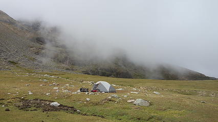
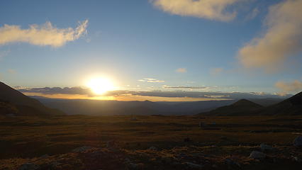
Since the typical high camp location was still covered with snow, we stopped about 150 feet below where a tiny flat spot perched on the edge of the abyss on the north side of the ridge offered just barely enough space to pitch the tent. The edge of a large snowfield was directly behind though so the ground was a bit damp from the afternoon sun melting it. With some doctoring I made the spot suitable for the tent. It had taken us probably 4.5-5 hours to ascend to high camp, which was about 5400 meters in elevation. While this was the highest both of us will have ever slept, due to progressively going to higher elevations over the course of the previous month we were ready for it. We hunkered down early since we had a 2:30am wake up call to begin the climb. We enjoyed the views from camp extensively, as this was one of the grandest places I've ever slept. 

Morning view from base camp; the ridge we ascended goes up in middle of photo
Beautiful base camp
Beautiful base camp
Our only neighbors at base camp
Hiking to the base of the west ridge
Looking up at the false summit of Illimani
Cresting the lower west ridge
This is where we decided to camp! I cannot imagine a better camp view
Illimani from the tent
Afternoon sun on Illimani
 
That's Sajama way out there to the west...the highest mountain in Bolivia


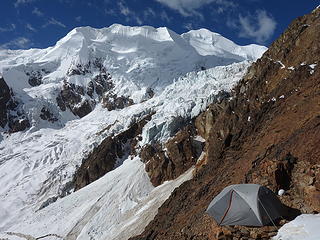
Around 10pm that evening, a solo hiker came up the ridge and was walking around us, obviously having seen our tent. Knowing there was no other good place to set a tent I assumed he would have to bivy, but to my surprise I heard him pitch his tent...I tried to imagine where and when 2:30am came and we were up I got the answer. He slept on some jagged rocks directly on the crest of the ridge, and his tent looked like a $20 Wal Mart tent! I was impressed haha. We were up before him though, and we started up the ridge at about 3:30am in pitch dark, going up the last 150 feet to the standard high camp location which was arguably the most technical part of the whole climb. With crampons already on, we had some class 3 rock covered with 45 degree firm snow to climb for perhaps 100 feet at which point we emerged onto the flat spot big enough for perhaps a dozen tents or so, however as we were warned it was indeed still snow covered. It was nice carrying the lighter packs for that more difficult stretch though. 

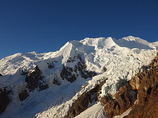
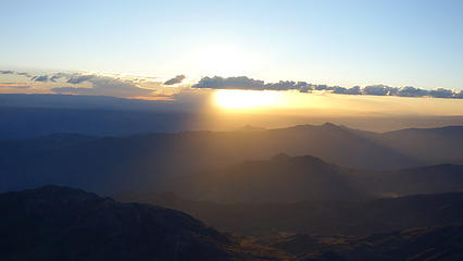
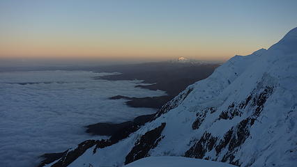
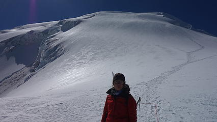
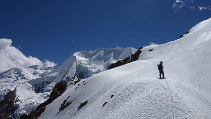
Continuing on, we soon stepped onto the permanent snowfields on the central part of the west ridge which were quite mellow for awhile. We made great time through this section and just as we started heading up steeper snow we noticed our solo friend emerge from his tent. The route was fairly easy to follow even in the dark on a very wide ridge. The steepness increased to about 35 degrees for awhile, then eased again and twilight started to lightly illuminate the sky as we neared 6000 meters elevation. Looking up at the remaining mountain ahead it looked pretty easy but the final 450 meters would take us an additional 3 hours! I watched the false summit off to our north as we slowly gained elevation, watching the sunrise ighting grow brighter and brighter and feeling the elevation a bit more. Just as the sun rose with the first rays of light, we reached a fairly flat location at around 6150 meters. Looking up we could see the summit ridge looking so tantalizingly close, but the steepest part of the ascent lie right before us. 200 meters of 45-50 degree snow, with a few large crevasses to navigate around lie ahead. We took a break here in the cold shade to eat and drink and I noticed the solo climber still quite a ways below us. Despite our slow pace, I think we were moving faster than he was, which with his late start I wondered if he would push through late into the afternoon. Since the route went up the west side of the mountain, you can safely climb the route until the early afternoon but by about 3pm the snow softens up and makes travel much more difficult, with potentially the chance to post-hole a bit. 

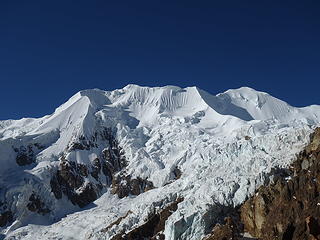
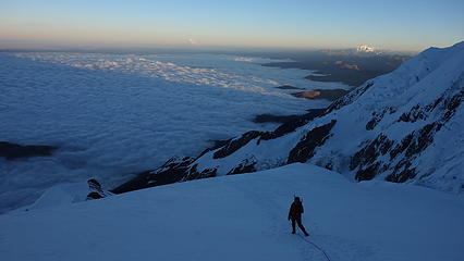
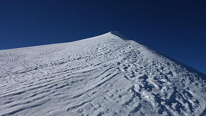
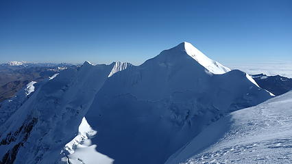
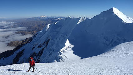
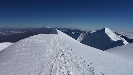
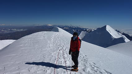
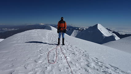
We pushed on and methodically ascended the final steep snow slope to the summit ridge, which we crested at 6350 meters and followed it up to the south. Finally we hit the sun and all that was left was a 100 meter ascent up a very, very gentle ice covered ridge that was wider than a football field. The summit area of Illimani is actually quite massive with three distinct peaks with the south peak being the highest. The east peak became visible once we crested the summit ridge but it's quite a bit lower at 6130 meters, and has its own name known as Layqa Qullu. 

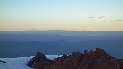
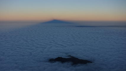
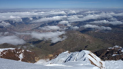
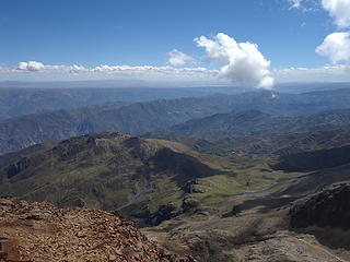
It felt like an eternity slogging up this final ridge for a distance of about 400 meters. We were both really feeling the elevation by this point, and I think with the addition of the wind that started howling as soon as we crested the summit ridge, the physical difficulty seemed to increase even though the gradient eased to 15-20 degrees. We could only take perhaps 4-5 steps at a time before having to catch breath, but at a time of 10am, we both stood atop Illimani, which smashed both of our elevation records. We were substantially higher than the low cloud layer that blanketed the landscape well below us, and nearby giants like Huayna Potosi and Illampu to the northwest were also visible.We stayed on the summit only about 10 minutes since it was now difficult to just stand there and breathe! We snapped a few photos and started down. As soon as we started hiking down it was almost an immediate improvement in breathing capacity. It felt like that my body passed an oxygen threshold at like 6400 meters but perhaps that was because I was 350 meters higher than my previous elevation record (which was made on Huayna Potosi just the week before). Regardless, it was a very memorable moment despite the slight misery. 

Twilight begins with a low layer of clouds
First rays of sun hit Huayna Potosi to the NW
The shadow cast by Illimani at sunrise
Elaine questioning her life choices...
Looking up the final bit on the summit ridge
View of the lower south summit from where we crested the ridge
Elaine making her way up the summit ridge
View north from the summit
 
Myself on the summit of Illimani
Looking down the route we ascended as the clouds part out below


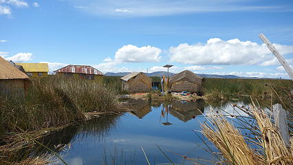
On our descent we passed the solo climber at about 6200 meters...it sounded like he was going to continue to the top so we wished him well and continued down. Descending the 45 degree upper section went smoothly and since we were dropping elevation so quickly I was starting to get a headache so I pressed on as I suggested we take a short nap at the tent before packing up and continuing the hike back to base camp that afternoon. At about noon we reached the tent and rested for an hour. It was really nice to lay down! By about 5pm we had made it back to base camp and pitched the tent one last time during our big South America journey, as the remaining 2 weeks of our trip would be spent playing tourist and doing day hikes as we traveled from La Paz, past Lake Titicaca and Isla del Sol, through Cusco, and on to Lima. Our hike out the following morning was as beautiful as ever as we passed through some small farms and were greeted by families with children just living a simple like at the base of Illimani. They couldn't be happier either which was pleasant to see. 

Upon returning to Estancia Una, we were able to catch a collectivo down to the next village, however this was lucky as normally the vans don't run on weekends. There just happened to be a village meeting with locals from all the nearby villages and the best location for it was the field in the next village down, called Quillhuana. Upon reaching this point we were told that a van might take people down to Palca in a couple hours so we patiently waited at the small Plaza de Armas which was supplied with a couple benches and some green grass the size of a standard suburban backyard. There may have been 50 people living here total! After a couple hours though a van did come and we made it to Palca, and since this town is larger, it was east to hop on another van to go back to La Paz. With Illimani complete, Elaine and I both agreed to relax the final 2 weeks of the trip and not climb anything else. After all, we had been more or less roaming the mountains nonstop for over 3 months! 

Descending Illimani
Descending Illimani


View down to base camp from our tent at high camp
 
Hiking the nice trail now off the west ridge
 
Nearing base camp once again...that's one big field
Illimani afternoon panorama


Views from the collectivo ride back to La Paz
 
More road views
More road views
Cordillera Blanca seen from the Highway 2 road from La Paz to Lake Titicaca
Cordillera Real seen from the Highway 2 road from La Paz to Lake Titicaca
Illimani Route Map


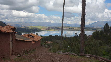
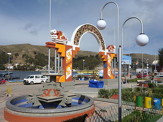
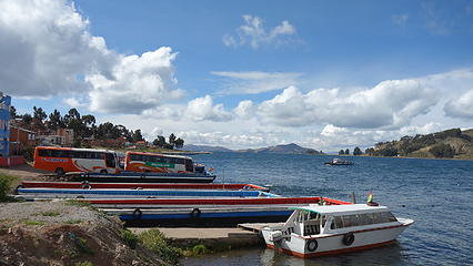
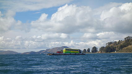
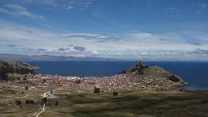
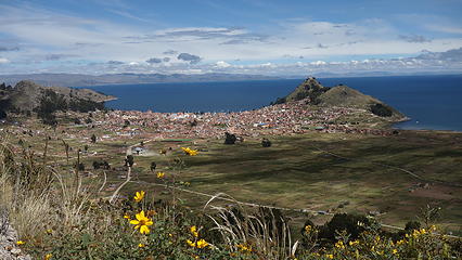
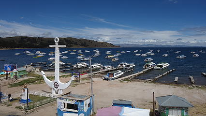
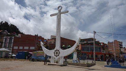
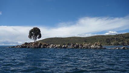
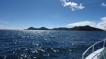
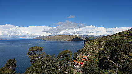
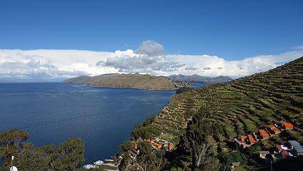
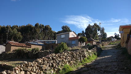
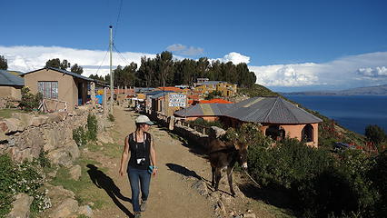
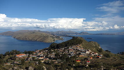
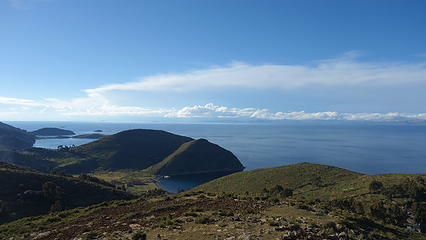
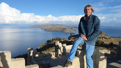
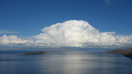
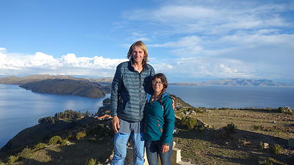
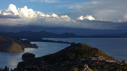
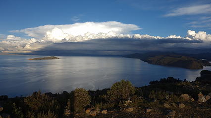
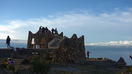
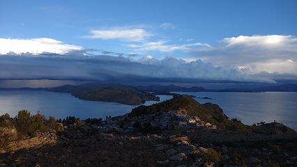
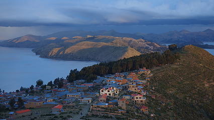
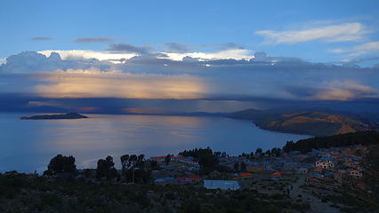
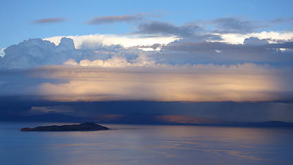
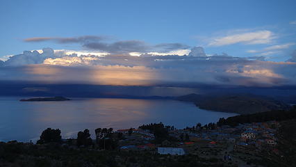
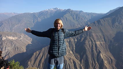
We moved on from La Paz after 3 awesome weeks there climbing 3 major summits in the Cordillera Real, and headed west to Lake Titicaca where we enjoyed the boat ride to Isla del Sol and walked to the high point of the island. We watched a brilliant sunset from this high point with views of the west end of the Cordillera Blanca and the lake surrounding us in all directions. It was super magical. We stayed in a nice hostel that night which unfortunately I somehow got very sick at and throwing up all night. That was the only time I got super sick on the whole trip which I consider myself lucky it happened at the end and not on a mountain! The walk down the hill to the boats the next morning was very hard as I was severely weakened from expelling everything...plus it was pouring rain! We did experienced some local culture and enjoyed the more simple things life has to offer in Bolivia and Peru though, and after leaving Isla del Sol we continued through Puno and on to Cusco. 


Taking the ferry across the lake; since the buses sometimes just fall into the lake off the barge, the passengers always take a separate boat!
View of Copacabana where we would take the boat to Isla del Sol
Looking down on Copacabana
Boat docks in Copacabana
 
Boating to Isla del Sol
 
Native style boats used by the ancient peoples of Lake Titicaca
View from Isla del Sol
Walking up the trails on Isla del Sol
Village on Isla del Sol
 
View of the village from the nice trail to the top
View to the west from the highpoint...Lake Titicaca is expansive!
Myself enjoying the view; Cordillera Real under clouds behind
Storms over the Cordillera Blanca off to the east
Storms over the Cordillera Real off to the east
 
Eerie lighting to the east
 
This structure was on the highpoint of the island
Incredible view
Incredible view
 
 
This was my favorite from the island; last rays of sunset light glow on the village on Isla del Sol
 
I guess it's called Isla del Sol for a reason!


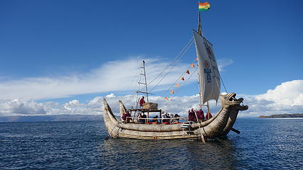
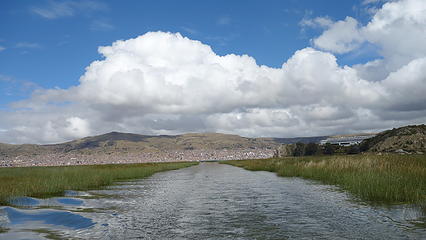
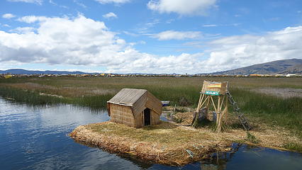
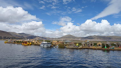
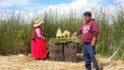
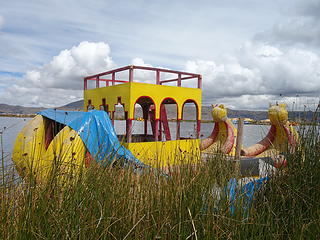
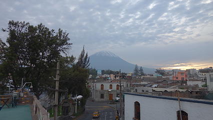
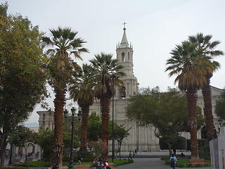
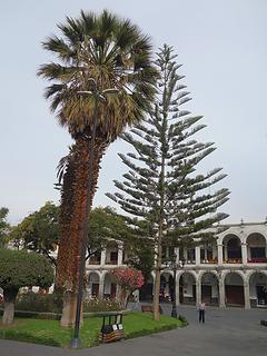
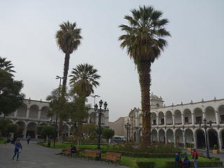
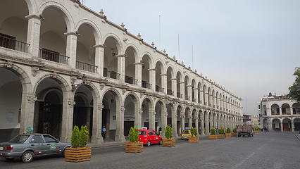
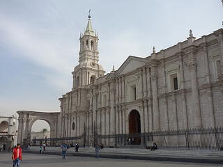
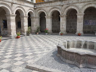
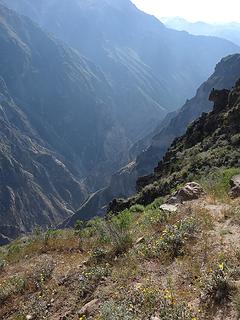
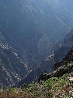
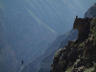
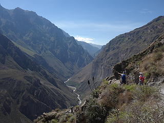
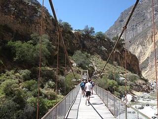
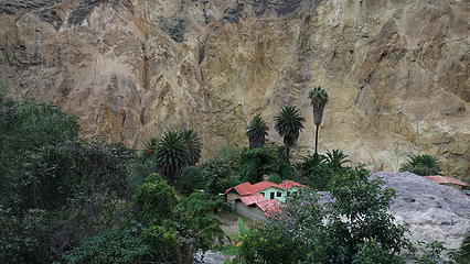
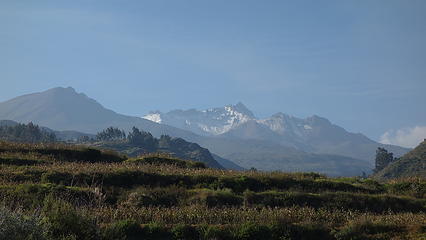
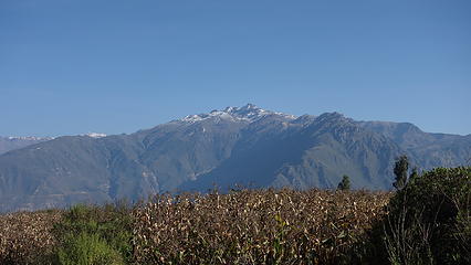
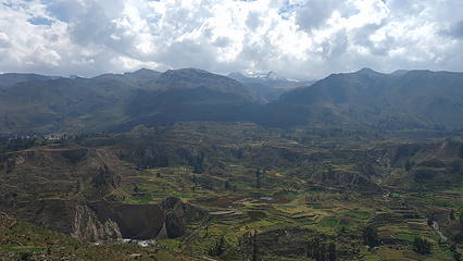
The remainder of our trip took us through Peru mostly to areas I have been before, but Elaine hadn't. We experienced the straw islands by taking the short boat ride out from Puno and then we bussed to Arequipa which was one of the more enjoyable cities I've ever been to. The Peruvian history here is amazing, and we took one of the city tours and learned a lot. The architecture in Arequipa was very interesting...it is nicknamed the white city and gor good reason. The photos really show what I mean here. We joined one of the Colca Canyon tour hikes which is a typical activity young travelers embark on from Arequipa and it was a fun way to meet other travelers and still get some hiking in (albeit easy for us). The ride from Arequipa to Colca Canyon was very long though, and on our way back we drove through a total snowstorm! That was something our Peruvian guides/driver was not prepared for. Because the road was covered with snow it took 6 hours to drive what only took us 3 to do on the way there. 

 
Island made of straw that grows in the shallow waters of the lake
 
Typical pets on the straw islands


Volcan Misti towers above Arequipa
Plaza de Armas in Arequipa
 
Architecture in Arequipa was stunning
Straight otta Spain...
 
A very cool looking courtyard
Condors take flight seen from the drive to Colca Canyon
Colca Canyon is actually quite large
 
 
Condors
Condors
View down into the canyon
Crossing the bridge at canyon bottom, about 5000 feet down. That was a knee jerking descent!
 
Our little oasis for the night
Sunrise from the canyon rim the next morning; we started hiking up really early
Enjoying the views from the rim of Colca Canyon
The mountains were still calling me


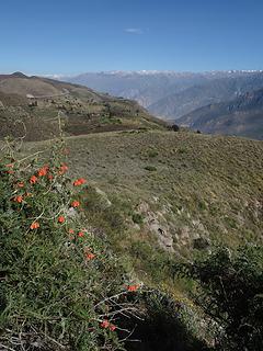
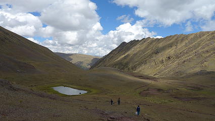
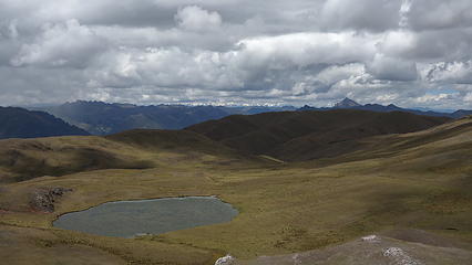
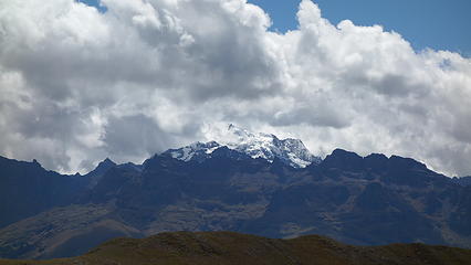
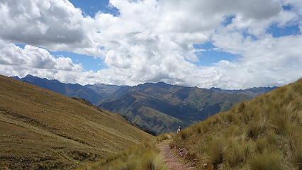
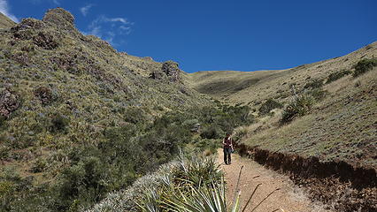
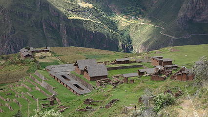
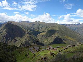
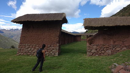
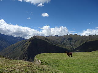
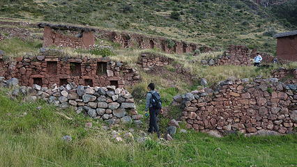
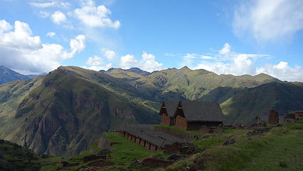
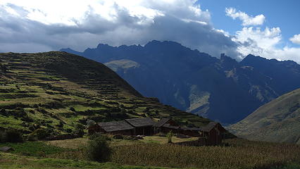
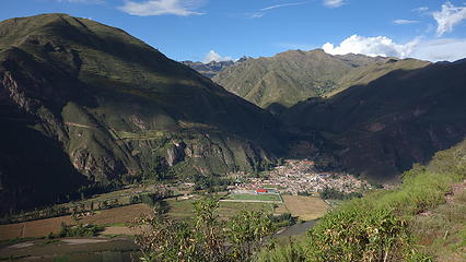
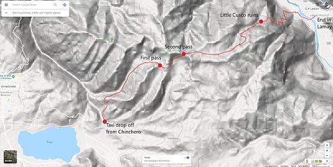
Continuing on yet another bus to Cusco, Elaine thought about doing the whole Maccu Picchu thing but since I had already done it, and since she didn't feel like the money required was worth it, we instead hiked to a lesser known Inca ruin site called Little Cusco (Huchuy Qosqo) which was actually really great (and a place I hadn't been to). We made a big point-to-point hike with it and was able to take collectivos/taxis to the starting point just outside Chinchero at the end of the road east of Laguna Piruay, and start hiking on a well used trail northeast into a beautiful valley, up to a pass at 4350 metes (see map). We then continued along the trail as we weaved around the gentle hills and passing numerous amazing viewpoints looking north towards the Cordillera Urubamba, which is a mountain range I haven't really climbed in yet. From here it was a long descent eastward down towards the Urubamba River valley. At an elevation of 3650 meters, tucked away in a small flat bench 700 meters above Lamay, we came upon Little Cusco. It's completely hidden from the towns in the valley below and was well worth the visit to explore. We then continued on the main trail that people use to hike up to it and got on another van in Lamay to take us back to Cusco It was a great way to spend a day in Cusco and explore a large area. 

Where our taxi dropped us off on the east ens of Laguna Piuray
Hiking into the nice valley
Somewhat rugged peaks at the head of the valley top out at 4520 meters
Hiking up to the pass
Beautiful lagoons amidst the high elevation grasslands
Looking into the rugged Cordillera Urubamba; I think this peak is Nevado Colque Cruz (Sahuasiray) at 5750 meters
Descending towards Rio Urubamba
 
Descending onto Little Cusco Inca ruins
Such a perfect setting; hiking to the ruins from above was so cool!
 
 
Open field in the center of the ruins


View down to Lamay where we would catch a van back to Cusco. The hike down was steep but a nice trail
Map of the route to Little Cusco that you can do as a point to point hike
Proudly powered by Weebly