My Capitol Reef NP page on SummitPost
Overview

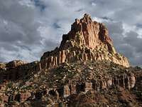
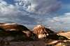
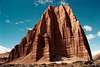
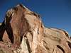
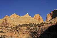
The Castle
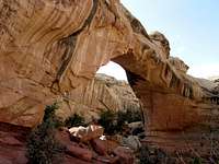
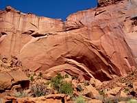
Hickman Bridge
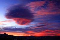
Vibrant Sunset
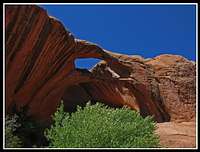
Brimhall Double Bridge
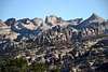
George Benchmark

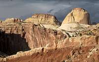
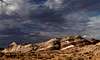
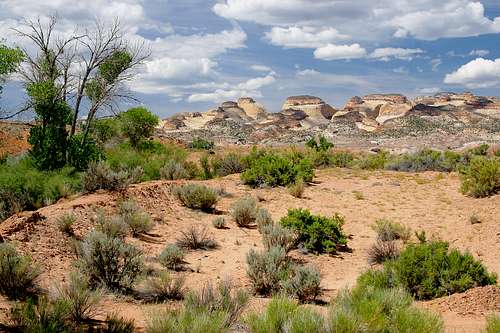
Sunset Point Colors
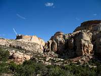
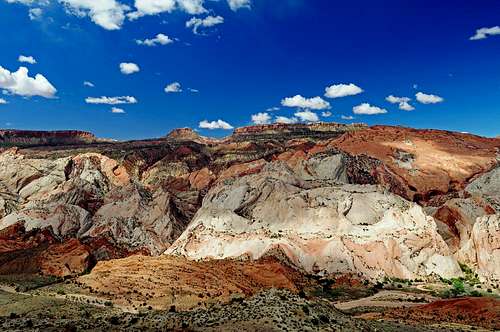
Waterpocket Fold

Sheets Gulch
Strike Valley Overlook
Halls Creek Overlook
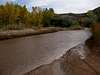
Fremont River
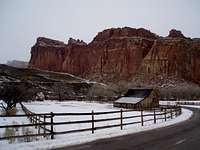
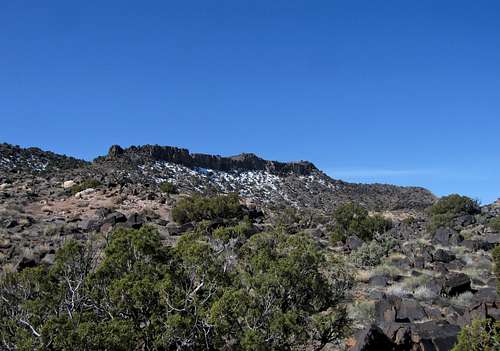
Capitol Reef in Winter
Capitol Reef National Park....why is called this? Well, the answer takes us back to the early settlers of the area. Settlers thought the white Navajo domes looked like the capitol building in Washington DC while others thought the long wrinkle in the rock layers looked like a oceanic barrier reef. Reefs in the ocean make it difficult to travel, as did the Waterpocket Fold. Settlers once struggled to cross the fold hence the name "Capitol Reef". It is the least visited national park in Utah and in fact, most people will drive through it without even realizing it on their way to Bryce or Zion Canyons. This makes Capitol Reef one of the best kept secrets Utah has to offer and it sure won't disappoint anyone who spends some extra to see the wonders hidden here. I like to call it an "outdoorsman Park" as opposed to a "tourist park" as most of the tourist crows don't spend much time here. There is no entrance fee for the park and the visitor center is located at the intersection of Highway 24 and the Scenic Drive in the middle of the park along the Fremont River. Capitol Reef is a strange park in the way it's shaped, it's about 75 miles long in the north to south direction but is at most only 10 miles wide in the east to west direction. In some places the park is only a half mile wide! Utah Highway 24 cuts right through the middle of the park following the Fremont River Gorge. This drive alone is very beautiful and the stretch of Highway 24 between Hanksville and Torrey is one of my all time favorite stretches of road. These two small towns are the closest to Capitol Reef, Hanksville on the east side and Torrey to the west. Every kind of outdoor activity you can think of is found at Capitol Reef in some way. There are some great summits and towers for those looking to climb something as well as deep slot canyons for those looking for a canyoneering adventure. There is even a whole network of back roads for people to see some of the hidden wonders without straying too far from their car. Many of these roads do require higher clearance vehicles but for those with only an extra day or a few hours this can be a great way to experience the beauty of Capitol Reef. The Park is typically divided into two distinct regions which are the Cathedral Valley District on the northern part of the park and the Waterpocket District in the middle and southern part. These two areas have drastically different characteristics and attributes that make them both special. So sit back...relax...and enjoy Capitol Reef National Park.
 |
 |
 |
Getting There - Cathedral Valley District

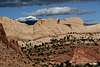
Henry Mountains

Henry Mountains and Pectol Pyramid
EPH Hanks Tower
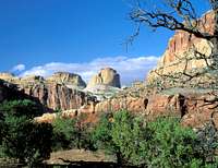
Golden Throne
Cathedral Valley is a large open area of unspoiled desert lands encompassing the northern most part of the park. This area is much different than the remainder of the park because its beauty isn't really associated with the Waterpocket Fols but rather the Entrada Sandstone Towers and open vistas. Just about everyone who goes to see Cathedral Valley drives the 59 mile loop tour which starts at the Fremont River Ford 11.8 miles east of the visitor center on Highway 24. The loop follows the Hartnet Road to the Cathedral Road (also known as the Caineville Wash Road) and returns back to Hwy 24 just west of the small town of Caineville located 18.6 miles east of the visitor center. The River Ford is easy to cross most times of the year, except during spring runoff or following a thunderstorm. The river bed at the ford has a hard packed, rocky bottom and water levels are normally only a foot deep. However with this being said it is highly advised you do the loop in a clockwise direction and ford the Fremont River first in case foul weather comes and the river levels suddenly rise, leaving you stranded. The access road to the ford does cross private land so please honor the posted no trespassing signs and do not camp here. Below is a mile by mile description of the tour that highlights the main attractions. Keep in mind this 59 mile tour will take at least 3 hours just to drive. When you include stops and short hikes you should probably plan on half a day for this. See the "Maps" section for a map of the park which shows this loop tour.

| Mile | Photo | Description |
| 0 |
 |
Fremont River Crossing - This marks the beginning of the tour where you must drive through the Fremont River. Usually the river is less than a foot deep but high clearance is required to make it across however this tour can be done without four wheel drive. Be sure to leave with a full tank of gas and emergency supplies as any help might be a long time away. |
| 9 |
 |
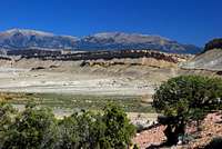
Bentonite Hills - The Bentonite Hills appear to be rounded masses of clay. Actually, they are formed of layers of soft stone of various colors, the surface of which turns to clay when exposed to weathering. What is seen by the eye is a veneer of color-banded, popcorn-like clay, which obscures the basic rock layers beneath the surface. When wet, the clay absorbs water and becomes gummy and very slippery, making vehicle or foot travel difficult or even impossible: hence the warning to avoid areas of clay when wet or when rain or snow threaten. More about the Bentonite Hills in the Geology section below. |
| 14 |
 |
Lower South Desert Overlook Spur Road - This short spur road has a sign for the Lower South Desert Overlook. This beautiful spot overlooks an interesting rock formation called Jailhouse Rock to the west. A short scramble from the main overlook takes you up to a high point with even more views to the south. |
| 27 |
 |
Upper South Desert Overlook Spur Road - This short road leads to my favorite overlook in all of Cathedral valley but that's because I was there when the lighting was perfect. Views to the north here are stunning with a series of orange towers below you which glow in the afternoon sun. Look closely and you can see the road way in the distance. |
| 27.5 |
 |
Junction of the Hartnet, Polk Creek and Caineville Wash (Cathedral) Roads - Turn right here and continue north heading down the very steep hill |
| 33 |
 |
Junction of Caineville Wash and Baker Ranch Roads - Stay straight and continue east. The Baker Ranch Road heads left (north) going through a large expanse of open desert reaching I-70 after 27 miles. |
| 33.1 |
 |
Gypsum Sinkhole Spur Road - Bear right and continue maybe a mile as the road wraps around and ends at a very deep (60ish feet) sinkhole caused by underground gypsum dissolving and creating large cavities. The overlaying sandstone then collapses leaving a sinkhole. |
| 42.5 |
 |
Lower Cathedral Valley Spur Road - Bear right and continue about a mile to the Temple of the Sun and Moon as well as Glass Mountain. This very interesting feature is made of pure gypsum and was pushed up likely by heat caused by the intrusion of many basalt dikes. Please refrain from taking gypsum pieces with you as this small feature won't last very long. Every rainstorm makes it smaller. |
| 59 |
 |
Junction of Highway 24 and Caineville Wash (Cathedral) Road - Reach the highway once again a couple miles west of Caineville. There is a Roadway Inn here, the only hotel for many miles. |
Basalt Dikes on Caineville Wash (Cathedral) Road
Black Mountain
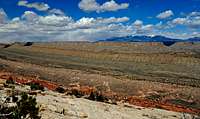
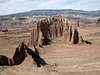
This 6,308 foot peak is likely the best place to go if you are itching for a summit hike. It lies 4.5 miles east of the Temples and Glass Mountain and can be easily climbed in a six mile round trip hike from where the road crosses Caineville Wash 2.6 miles east of the spur road to the Temples. Although the route I have done on this peak is from the north using Salt Wash as an approach, Bob Sihler has a great description of a south side route from Cathedral Valley that is most likely shorter than the route I have done. His Black Mountain page is linked above. As you can probably guess, the mountain is black but why? Although all the surrounding rocks are red, orange or white colored sandstones, the rocks on Black Mountain are dark colored basalt which is the result of lava flows fed by dikes that cut through the rock layers all the way to the surface in some places. Driving the Caineville Wash Road you will see many thin but very long dark colored linear towers of basalt that stand proud above the ground as they are much more resistant to erosion than the surrounding sandstones. These towers are the volcanic dikes. The source of this volcanism and why there was volcanic activity in central Utah is still not exactly known. Perhaps it was related to the San Juan volcanic field where huge super-volcanoes existed in the present day San Juan mountains in SW Colorado 30 million years ago.
Climbing Black Mountain from the north
Getting There - Waterpocket District
The Waterpocket District is the bread butter of Capitol Reef. This long, monoclinal fold in the earth exposes all the rock units you see in southern Utah in perfect sequence as you drive along Highway 24 from east to west through the Fremont River Gorge. See more in the geology section below. Although the Waterpocket Fold extends well north of Highway 24 and west of Cathedral Valley, the fold in this part of the park is less dramatic and offers less in the way of deep canyons and big towers. The area surrounding Highway 24 and extending south all the way to the Bullfrog Marina on Lake Powell is one of the true gems of Utah. A loop tour similar to the Cathedral Valley tour, however much longer, can be done for those people with less time to spare. This loop starts at the visitor center on Highway 24 in the middle of the park and it is best done in a clockwise direction. It is very important your gas tank is full for this trip as the loop is 125 miles long and side trips are a must since the area is so beautiful. From the visitor center follow Highway 24 east for 9 miles to the Notom Bullfrog Road where the fun part begins. Turn south on this road which is paved initially. This intersection also has a nice restroom facility on the north side of the highway. Below I will describe the three main road tours within the Waterpocket District starting with the popular loop tour.
Waterpocket Loop Drive
| Mile | Photo | Description |
| 9 |
 |
Junction of Highway 24 and Notom-Bullfrog Road - Turn south onto this road and climb up the first hill. This whole loop can be done in a passenger car when the conditions are good however since many of the roads atr on Bentonite Clay, nothing can drive them when they are wet. Be sure to leave with a full tank of gas and emergency supplies as any help might be a long time away. |
| 11.2 |
 |
Pleasant Creek Dispersed Camping - After 2.2 miles from the highway you will cross a small bridge over Pleasant Creek and just after the crossing there is a spur road heading sharp left and wraps around to a few very nice dispersed camp spots right along Pleasant Creek that are outside the National Park boundary. It is only about a quarter mile to eash site but the brush and cottonwood trees hide the area nicely. |
| 19.1 |
 |
End of Paved Road - Here the pavement ends and dirt/clay roads remain for a long time. |
| 21.8 |
 |
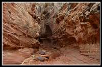
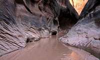
Sheets Gulch - Here the road crosses a fairly large wash known as Sheets Gulch. You can pull off the road and drive up the wash for about a mile before you are forced to park. Be sure you don't park in the wash bed itself in case it rains. Further upstream, the gulch has some very photogenic narrows with no technical difficulties. The gulch goes on for nearly 10 miles so pick a turn-around point based on your allotted time. Just before Sheets Gulch you will also cross Burro and Cottonwood Washes both of which are signed. ).8 miles past Sheets Gulch is Sandy Junction. Continue straight (south). |
| 31 |
 |
Cedar Mesa Campground - This campground is one of the two operational backcountry campgrounds within the park. A free permit is required to camp here and is run on a first-come first-serve basis. No water is available here but there is a pit toilet facility. |
| 43 |
 |
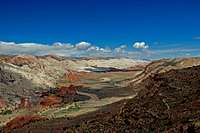
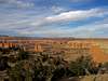
Junction with the Burr Trail - This stretch of road between the Cedar Mesa Campground and the Burr Trail is exceptionally beautiful. To continue the loop, turn right here and begin climbing the steep switchbacks up to the top of the Waterpocket fold. Continuing straight will take you on the Halls Creek/Bullfrog Marina route (See Below). Heading up the switchbacks, the views will continue to expand and at the top, there is a nice picnic area and this spot is known as the Strike Valley Overlook. Views of the Henry Mountains are stunning. |
| 80 |
 |
Town of Boulder and Junction of Burr Trail and Highway 12 - Continue west on the Burr Trail which becomes paved the rest of the way to Boulder. See lodging section below for more information about Boulder. During this long drive you will pass through amazing country within the Grand Staircase Escalante National Monument and will pass the signed Moody Road junction, drive through Long Canyon and pass the Grand Gulch Trailhead. |
| 100 |
 |
Junction of Highway 12 and Lower Browns Reservoir Road - Highway 12 north from Boulder ascends the eastern flank of Boulder Mountain. The hot desert gives way to cooler air with big aspen forests that are glorious in the fall. Snow lingers up here well into spring and you can look down on Capitol Reef to the east and see the fold very well. This spur road heads east off the highway and descends steeply for 3.8 miles to Lower Browns Reservoir where abundant camping and even fishing can be found. With 4WD you can continue past the reservoir on the South Draw Road all the way to the Scenic Drive (See Below) |
| 117.2 |
|
Town of Torrey and Junction of Highways 12 and 24 - Continue winding across Boulder Mountain and descend to Torrey (More Information Below). Turn right onto Highway 24 and continue 9 miles down the big hill back to the visitor center. You will pass Sunset Point on the way which makes a great photo stop late in the afternoon |

Halls Creek/Bullfrog Marina
From the junction of the Notom Road and the Burr Trail, continue straight (south) instead of climbing up the steep switchbacks. There is a big sign at this junction and is impossible to miss. After two miles you will reach a short spur road heading off to the right (south) to The Post corral. Remnants of an old corral are still found here and this is the trailhead for a variety of hikes and canyons including Surprise and Headquarters Canyons, The Post Cutoff Trail, and Muley Twist Canyon. Continue another 8.7 miles past the Post corral and around a very broad left turn in the road and reach a signed junction with the Burr Trail. It is important you turn right here and continue south on the now paved road. After only 0.9 miles on this road you can turn right at the signed Halls Creek Overlook dirt road. This road loops around Big Thompson Mesa and takes you to the Halls Creek Overlook Trailhead for access to the southern end of the park. The most popular things people see way down here is the Brimhall Double Bridge and Halls Creek Narrows. Some very technical slot canyons are found beyond the southern park boundary for those who dare to venture for miles down Halls Creek. If you continue south on the paved road (Burr Trail) it will descend steeply down to Bullfrog Creek where it fords the creek. This crossing is almost always dry and passable for any car but after a storm or a very wet winter season water can flow here. After crossing Bullfrog Creek the road ends at a junction with Highway 276. Turning left here will take you north up to Highway 95 and on to Hanksville. Turning right will take you to the Bullfrog Marina after only a few more miles.

Halls Creek Overlook
The Scenic Drive
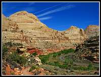
The Scenic Drive starts at the Visitor Center and heads south through the historic town of Fruita and provides access to Cohab Canyon, Grand Wash, Capitol Gorge, Pleasant Creek, and the South Draw Road. It's an 8.2 mile paved road with dirt spur roads into Grand Wash and Capitol Gorge that are accessible to ordinary passenger vehicles in good conditions. Unfortunately during the off season these roads are gated so for those people with the tough 4WD vehicles these roads will still be closed in winter. This road is not a loop, so you must return the way you came. There is a five dollar entrance fee that is charged for this road using the honor system. This is the only source of public income for Capitol Reef National Park so it's best you pay the fee. The road ends for passenger cars at Capitol Gorge where a nice dirt road leads to a popular trailhead. The Golden Throne Trail takes off from here. Four wheel drive vehicles can continue on the South Draw Road as it parallels the western flank of the Waterpocket Fold to Pleasant Creek and beyond all the way to Lower Browns Reservoir and Highway 12.
 Capitol Reef Domes |
 The Fluted Wall |
 The Golden Throne |
 South Draw Road Views |
Capitol Reef National Park
Canyoneering
The opportunities for canyoneering are decent in Capitol Reef National Park although certainly not as good as Robbers Roost Country or Escalante region. Most of the known canyons here are hikes but a few gems are technical descents. All the major canyons are located in the Waterpocket District and have relatively short approaches from where you would park. Below is a description of the major canyons in Capitol Reef ordered from north to south. Every one of these are beautiful in their own way but some of them are just out of this world. Be weary though of flash floods and never enter a narrow canyon when rain is in the forecast. Always bring plenty of water especially in the summer when standing water will be next to none. Do take the time to explore some of these if you ever find yourself at Capitol Reef. If you decide to embark on a technical canyon adventure, be sure you know how many rappels there will be, what the anchors will be like (if any) and how to build your own anchors. Also be sure you know about any keeper type potholes and be prepared and have the skill to be able to escape them. The typical basic technical canyoneering gear for canyons where there are no keeper potholes involves a rope that is at least twice as long as the longest rappel in the canyon, harness, belay device, lots of webbing and slings, and dry suits/dry bags depending on water levels. This is the bare minimum and depending on the difficulty of the canyon, extra gear like an ibis hook, may be needed.| Canyon | Photo | Description |
| Spring Canyon |
 Spring Canyon Alcove |
Spring Canyon is a deep but wide gorge type canyon with Wingate Sandstone walls. This is a very long canyon that originates up on Thousand Lakes Mountain well to the northwest and meanders through the northern part of the Waterpocket Fold. It eventually reaches Highway 24, heads under the highway and turns into the Grand Wash. The Grand Wash portion of this canyon is a very popular hike (See Trail Guide). Many People enter Grand Wash (lower Spring Canyon) at an unmarked parking area 3.6 miles east of the visitor center. If you wish to enter Spring Canyon at the midway point start at the Chimney Rock Trailhead 3.2 miles west of the visitor center. The distance you wish to hike in this canyon depends on your allotted time and whether or not you have a car shuttle. |
| Capitol Gorge |
 Capitol Gorge |
See Trail Guide Located just south of Grand Wash, this canyon is an easy out and back hike and very popular. The Scenic Drive ends at Capitol Gorge and a dirt road continues a short ways in the gorge along the dry creek bed to the trailhead. |
| Burro Wash |
 Burro Wash |
This narrow slot canyon is located 7.8 miles south of Highway 24 on the Notom-Bullfrog Road. A small sign marks Burro Wash where you can park or drive up the dry wash. On your way up, always take the left branch at wash junctions. About 2 miles from the Notom-Bullfrog Road, the canyon begins to slot up as it cuts into the Navajo Sandstone. Beyond this point the canyon becomes more difficult and short scrambling up and over chalkstones and route finding skills are needed to bypass big headwalls. After an additional 2 miles (4 miles from Notom Road) the canyon comes to a very large pour-off that turns just about everyone around. Simple retrace your steps. To complete the entire canyon, you must start at the upper (west) end of the canyon from the South Park Road just south of Pleasant Creek. Doing this the canyon is technical and more advanced canyoneering or climbing techniques, route finding and special gear is required. From the top of the canyon descend the first couple miles which involves rappelling, swimming and lots of scrambling to the same large pour-off described above and rappel. You may need a car shuttle or you can return via Pleasant Creek. |
| Cottonwood Wash |
 Cottonwood Wash |
Just 1.3 miles south of Burro Wash the Notom Road crosses Cottonwood Wash with another small sign. Walk or drive west up this drainage and stay left at a wash junction after a mile. The next two miles of canyon are narrow, require lots of scrambling and swimming and you must be pretty thin to mae it through. 3 miles from the Notom Road the canyon comes to a 35 foot pour-off marking the end of the route. This canyon can also be started from the upper (west) end from South Draw Road but it will be technical with many rappels. |
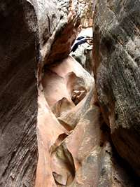
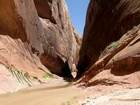
| Sheets Gulch |
 Sheets Gulch |
Sheets Gulch is located 13 miles south of the Highway 24 on the Notom Road. A sign marks where the road crosses the wash. There is a small parking area on the upstream side of the road or you can turn right just before the bridge and drive upstream in the dry wash for maybe a mile (4WD only). Walk the easy wash up as far as you would like and turn around. It is a very photogenic slot canyon. Some people have a car shuttle at Tantalus Flat and do a nine mile through hike of the canyon. The road to Tantalus Flat is 4WD only. |
| Upper Muley Twist Canyon |
 Overlook |
This canyon is much more than just a canyon. There are at least five really good arches you can see and incredible views from the top of the Waterpocket Fold. From the Burr Trail and Notom-Bullfrog Road junction, ascend the switchbacks and 3 miles from the junction turn right on a side road with a sign for Upper Muley Twist Canyon. 4WD vehicles will be able to drive about 2 additional miles to the end of the road. This hike has big arches, nice narrows and great views. Well worth it. |
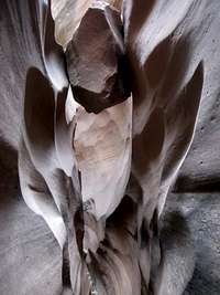
| Lower Muley Twist Canyon |
 LMT Alcove |
There are various ways to see this canyon. It is simply the lower half on the much longer Muley Twist Canyon which parallels the west side of the Waterpocket fold for about 20 miles before cutting through and draining into Halls Creek. One can start at the top of the Burr Trail Switchbacks and descend the canyon south. One could also start at the Post and hike down Halls Creek then up Muley Twist Canyon then hike the Post-Cutoff route. No matter which way you go, this canyon is no more than a long hike. There are big alcoves in this canyon though and the views of the Henry Mountains from the top of the fold are amazing. |
| Surprise andHeadquartersCanyons |
 Halls Creek Narrows |
These two short canyons are nice hikes which start at a small signed parking area right where the spur road leads south to The Post corral. Hike the trail west towards the Waterpocket Fold and enter either canyon. They are right next to each other. |
| Halls Creek Narrows |
 Halls Creek Narrows |
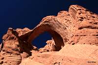
This is likely the most dramatic canyons in all of Capitol Reef. Not only that but it is much more remote than all the others. Most people take 2-3 days to see this canyon however there is a Shortcut Route that makes it a good day hike. The normal route starts at the Halls Creek Overlook and descends the trail to Halls Creek then continues south along the creek to the Narrows. The narrows is 3 miles long and usually people return over Hall Divide however I would recommend making a side trip up to the rim of the narrows at some point to get a nice look down. Some hidden arches scatter the area as well. Many people also visit the Brimhall Double Bridge located a short hike up Brimhall Canyon which lies just across Halls Creek from where the trail meets it. |
Just to the south of the park boundary beyond Halls Creek Narrows, there are two very technical canyons called Happy Dog Canyon, and Poe Canyon (AKA Smiling Cricket Canyon). These two canyons are some of the toughest around requiring aid climbing, intense pothole escaping and many swimming rappels.

 Lower Muley Twist |
 Saddle Arch |
 Navajo Sandstone Textures |
 The Grand Gulch |
Climbing
Although the Utah desert is mainly a location to hike and climb in canyons, Capitol Reef has a few fantastic summit climbs to embark on. Likely the best two are George Benchmark and Ferns Nipple. These two peaks lie in the heart of the Waterpocket Fold and both require third class scrambling ability and good route finding skills. Start a climb of George Benchmark at the Capital Gulch Trailhead and use the Golden Throne Trail. One can continue to Ferns Nipple from here however most people climb this peak starting from Grand Wash and locating a very well hidden route to the base of the pyramid. Ascending the summit pyramid of Ferns Nipple is very loose and dangerous. Views from both of these peaks will be nothing short of spectacular with everything visible in every direction. Other towers that have been climbed include EPH Hanks Tower, The Castle and Pectols Pyramid. Climbing to the top of something can be very rewarding here.
 |
Geology

Stratigraphy Column of the Capitol Reef area
|
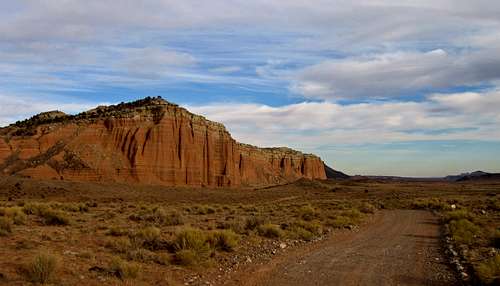
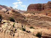
The geology is what makes Capitol reef so special. Layer upon layer of sandstone are piled high and these different rocks in conjunction with the tectonic forces and the actions of water define the area. The rock layers at Capitol Reef all dip towards the east at moderate angles. Due to this dip angle, all rock units can be seen in sequential order, youngest to oldest, from east to west. The dominant rock layers seen on the east side of the Waterpocket Fold from Notom for example are the Entrada Formation, Carmel Formation, and Navajo Sandstone. These are the youngest rocks seen in the reef. Further east towards Caineville and the Bentonite Hills in Cathedral Valley the rocks are even younger as the Morrison Formation and the Mancos Shale is seen. The thick Navajo Sandstone makes up the tops of many of the towers atop the reef like Golden Throne and Pectols Pyramid. From Sunset Point on the west side of the reef you can see the Kayenta Formation, the Wingate Sandstone and the Chinle Formation. The big orange cliffs seen from the west side is the Wingate Sandstone and this rock unit forms these distinctive cliffs all over southern Utah. Further west in Torrey, the deep red colored rocks seen there is the Moenkopi Formation. See the strat column to the left for information about these rock units. They were all deposited during the Triassic and Jurassic Periods (200-250 million years ago) in a time of hot dry desert climate similar to the Sahara desert of today. Massive amounts of burial from later deposits caused the sands to lithify into rock due to the increased pressure and the flow of water which filled the pore spaces with a bonding mineral such as calcite. After millions of years deep underground, erosion began to take over once the area was uplifted extensively 65 million years ago driven by the Laramide Orogeny. This mountain biulding event shaped all of western North America as we see it today. The formation of the Rocky Mountains from Canada all the way to New Mexico as well as the uplift of the Colorado Plateau in Utah is all a result of the Laramide. Massive amounts of erosion began to occur and once again the deposits laid down 200+ million years ago are seen at the surface as rock layers. The formation of the Waterpocket Fold, a monocline type fold is a result of the Laramide as the same compressional forces that uplifted the Colorado Rockies buckled and faulted the brittle sedimentary layers seen in most of the Colorado Plateau. Late Laramide rifting (25-35 million yars ago) caused a different type of tectonic activity which included normal faulting, intense volcanism in the San Juan area of Colorado and the formation of the Basin and Range Province in Nevada and western Utah. Since then, 25+ million years of erosion shaped the landscape the way we see it today. The western United States has one of the most diverse and complex geologic histories in the world and Capitol Reef is certainly one of the geologic wonders found in our great country. While you're here try to wrap your head around the immense geologic processes that took place to form what you see.
|

Capitol Reef Cross Section showing how the rocks have been folded
Map and Trail Guide
Shown below is the park map and the trail guide that is provided by the National Park Service.

Capitol Reef Map
|
|
Nearby Areas to Explore
A plethora of attractions and sights are only a short ways from the park. Boulder Mountain lies west of Capitol Reef where you can find a nice reprieve from the hot desert air. This 11,000 foot high flat topped mountain extends for over 400 square miles where many small lakes can provide great fishing. The area has a drastically different plant life and supports aspen forests and beautiful meadows. Just about all of Boulder and Thousand Lakes Mountain to the north lie within the Dixie National Forest. They formed as a result of Tertiary volcanism likely related the the San Juan volcanic field. Here think basalt flows originating from long dikes covered the sandstone layers and flowed to the lowest areas topographically. This is interesting to think about since Boulder Mountain is the highest area around. However the basalt rocks are much harder than the surrounding sandstone rock layers and they provided a "cap" that shielded the soft sedimentary rocks below from eroding and 20 or so million years of erosion have taken effect on the areas not covered by basalt. Therefore, these areas today (such as Cathedral Valley) sit well below the basalt covered Boulder and Thousand Lakes Mountains.The Henry Mountains are a small chain of mountains to the east of Capitol Reef. They are primarily accessed by Highways 95 and 276 on their east side. The highest peak, Mount Ellen at 11,522 feet, provides a very nice summit hike with beautiful panoramic views of all the surrounding desert country. These peaks are very prominent as they rise at places over 6000 feet from the surrounding desert. Only a few people access these mountains from the west as the area between Capitol Reef and the Henry Mountains only has one road that cuts through. The BLM operates the McMillan Campground which lies to the east of Notom on the McMillan Springs Road. From Sandy Junction in Notom, leave the Notom-Bullfrog Road and turn east onto this road and follow it as it winds its way over rough terrain to the campground and beyond to Bull Creek Pass at the crest of the Hennry Mountains. You can then continue down the east side to Highway 95. The geology of the Henry Mountains is very interesting. Tertiary aged (~15 MYA) intrusions of diorite from within the earth's mantle forced itself upward into the overlying layers of the earth's crust to form high domes called laccoliths. Today these domes form the five major peaks of the Henry Mountains. Erosion has now exposed the hardened diorite core of the mountains. The domed and arched sedimentary rocks are seen as flanks of the mountains range. These mountains were the last to be officially mapped in the lower 48 states.

Red Tape
There is not much of it to speak of here. The park does ask you to pay a $5 fee to use the Scenic Drive past the Fruita Campground. This is on an honor system though but since this is the parks only source of outside revenue, it's best to pay the fee. If you plan to camp anywhere within the park boundaries whether in the backcountry or not, a free permit is required and can be picked up at the visitor center. The mailing address for the park is shown below. Typical hours of operation for the visitor center are 8:00am - 4:30pm with extended hours in the summer where they close at 6:00pm.Information Packet Request
Capitol Reef National Park
HC 70 Box 15
Torrey, UT 84775
(435) 425-3791
Camping, Lodging, and Towns
CampingThe Fruita Campground is the only developed campground within the park located right across the street from the visitor center. It's based on a first-come first-serve basis and there is a $10/night fee. For Golden Age/Senior Pass holders the charge is $5/night. There are 71 RV/tent sites available each with a picnic table and a grill. The campground is open year round but during the spring and fall months it fulls each day by early afternoon.
There are also two primitive campgrounds in the park. One (Cathedral Valley CG) on the Cathedral Valley loop road near the Upper South Desert Overlook and the other (Cedar Mesa CG) located south of Notom on the Notom-Bullfrog Road. Neither of these have running water but pit toilets are available. Free permit required. You can also camp pretty much anywhere in the park with a free backcountry camping permit. Car camping makes the most sense and some very nice backcountry places include The Post corral, Halls Creek Overlook, and Strike Valley Overlook. The best backpacking destination is Halls Creek Narrows.
Towns
| Town | Photo | Description |
| Hanksville |
 |
Hanksville is the main town to the east located at the intersection of Highway 24 and 95. If you haven't been here before the best place convenience store is the Hollow Mountain Store and gas station (yes the store is built into a mountain!). The best place to eat is Stan's Burger Shak just across Highway 95 from Hollow Mountain. Here you can get really good half pound burgers for $3.50 each!! I get about 3 or so every time I pass through. There are also a few more good places to eat, 4 hotels, 2 campgrounds and the M.A.C. Auto Towing Service which I have seen many people to need. |
| Caineville |
 |
Located about 11 miles east of the park boundary on Highway 24. The only thing this really small town of maybe 50 people has is a Rodeway Inn on the north side of Highway 24 and the Luna Mesa Oasis Restaurant. However it is a beautiful place especially in the spring when all the nearby farmlands are filled with lush green grasses. |
| Torrey |
 |
Torrey is the main town on the west side of Capitol Reef located at the intersection of of Highways 12 and 24 a few miles west of the park boundary. Far and away the best place to eat here is the Rim Rock Patio however Slackers Burger Joint is pretty good as well. They will serve you faster if you're in a hurry but The Patio is a classic with live music in the evenings (usually open late), dart board, and a Disk Golf Course! There are 14 hotels to choose from in town so there should not be a shortage there. At least 5 gas stations are also available. I love this place. |
| Boulder |
 |
Boulder is a small town of about 200 people located at the intersection of the Burr Trail and Highway 12 to the southwest of the park. Boulder is actually thought more as the gateway to Escalante rather than Capitol Reef but regardless, it is a great place to stop. There are only 3 places to eat and all are pretty expensive. There are also a few motels and a couple gas stations serving 24 hour gas. I personally have never bought anything here though. |
Seasonal Considerations
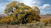
The time of year you visit Capitol Reef can highly dictate what you decide to do. Summers can often be brutal with high temperatures above 100 degrees being a common everyday occurrence. Winter can bring very cold nights and snow. Therefore the best time to visit is spring and fall. During mid-summer, spending more time in higher elevation places like the Henry Mountains or Boulder Mountain would be welcome while in winter these high mountains are covered in snow. During the early spring runoff, many canyons will be flowing with water making their overall difficulty increase. Halls Creek Narrows typically flows through April for example. Some slot canyons are great to do in the summer if lots of swimming is involved but be weary of summer thunderstorms that suddenly can turn the canyon into a death trap. Also try and avoid any slot canyon that has a long approach during the summer. Halls Creek Narrows is not a mid-summer hike! Spring and fall are typically the driest times of year and have highs usually in the 70's and lows in the 40's. Springtime also brings the lush green colors found in Fruita which can make for some beautiful photos with the red and orange rocks in the background. The cottonwood trees along the Fremont River turn bright yellow in the fall generally peaking in mid-October which also is very photogenic. Below is a table describing the climate of Capitol Reef provided by Scott in his page.| MONTH | HIGH | LOW | PRECIP | SNOWFALL |
| JAN | 41 | 19 | .52" | 5.2” |
| FEB | 47 | 25 | .43" | 2.0” |
| MAR | 58 | 33 | .58" | 2.7” |
| APR | 66 | 39 | .54" | 0.7" |
| MAY | 76 | 48 | .63" | 0.1" |
| JUN | 87 | 57 | .43" | 0 |
| JUL | 92 | 64 | .91” | 0 |
| AUG | 89 | 62 | 1.15” | 0 |
| SEP | 81 | 54 | .80” | 0 |
| OCT | 68 | 43 | .71" | 0.5” |
| NOV | 52 | 30 | .62" | 1.8" |
| DEC | 42 | 21 | .26" | 2.4" |
External Links
CURRENT WEATHER FOR TORREY, UTAH and CAPITOL REEF NATIONAL PARKNOAA Weather for Capitol Reef National Park
CAPITOL REEF LINKS
Capitol Reef National Park
Camping Regulations
Climate Overview
Fruita History
Road Tours Overview
More Geology
Capitol Reef Natural History Association
Regional Map
Boulder Mountain Fishing

Halls Creek Overlook Panorama