Bowback mountain - 12,351' - north ridge Class 2+
Sundance mountain - 12,262' - south slopes Class 2
Whitetail Peak - 12,551' - north couloir class 4
silver run peak - 12,542' - Class 2
july 2012
My Bowback Mountain page on SP
MY SUNDANCE MOUNTAIN PAGE ON SP
MY WHITETAIL COULOIR PAGE ON SP
Introduction
This is the story about a major pursuit of mine I started researching back around Christmas in 2011, nearly a year ago. Oddly enough it all started when I posted a thread on 14ers.com
asking the masses there for advice on guidebooks for different parts of North America ranging from Alaska, Alberta, the Coast Ranges of BC, the Absarokas, Lost River Range and the Beartooth Mountains. I got all kinds of great responses and was exposed to many books I didn't know of before, some of which I bought. However what really struck me was when my friend Jed, (rockthrowjoe on SP) mentioned that there is no comprehensive book for the Beartooth Mountains in Montana. Now it didn't hit me at first but as the new year came and I continued my quest for winter 14ers in Colorado, the idea started to come to me more and more. I have always wanted to write a guidebook but thought it would be impossible since all the great ranges in the US already have really good ones published and competing would really be a challenge, but after doing more extensive research, I never found a comprehensive guide for the Beartooth Moutains and I started thinking of ways I could make one, and turn one of my dreams into a reality.
As the winter pressed on, I was in my last semester of college and in no mood to start a permanent job after graduating so I took advantage of an opportunity to really live life by planning to take the summer of 2012 off altogether. I began making the plans for which states I would visit, which mountains I would climb and who I will be climbing with from May through August. The lease at my apartment I had ended April 31st so that is where my trip really began. I had enough money saved up to spend on food and gas for the summer as well so all was looking well. I spent all of May and June in Colorado traveling, climbing centennials, sport climbing with friends in Golden, and living life care free. I often returned to Golden from the depths of Colorado to visit with friends and usually drove up to Genessee Park to stay the night under the stars at the summit. I slept next to my car on countless dirt roads and made many new friends while climbing peaks all over the state.
Then around June 21st, I picked up Josh Lewis in Denver and we climbed a bunch of cool Colorado peaks together for a week and a half. We even wandered over to Utah for a few days so he could finally get the chance to do a slot canyon. He bought a one way bus ticket to Denver for this trip, and my superb planning skills helped bring him back home to WA. Since I had a couple friends in Colorado (Stephan and Andrew) who wanted to climb Rainier around the 4th of July, Josh and I teamed up with them and we drove to Mount Rainier...not in my car (sweet my car gets a break!). We climbed the Emmons Route July 6-8 and afterwards, Josh took a bus back home and the three of us drove back to Colorado where I picked up my car and was once again on my own for a couple days. However the next big chapter of my summer was just about to begin, where Stephan and I would head to Montana. This chapter of my summer is what this trip report describes.
We were going to climb the Montana 12ers, hopefully by multiple routes and document them well enough to write a detailed guidebook for the Beartooth Mountains with focus on the 26 ranked 12,000 foot peaks. All of Montana'a 12ers are in the Beartooth Mountains. I spent hours before the summer started looking at each peak and potential routes on Google Earth, reading texts and trip reports already published and planning out a sequence of climbs for a period of five weeks. These routes ranged from steep snow climbs, to difficult scrambles all the way down to long talus slogs. When July 12th rolled around though, Stephan and I began the journey by taking the drive north through Wyoming to Red Lodge, Montana where we spent our first night just outside town. As a generic overview of what this report will cover, I will describe in detail our experiences on 18 of the 26 12,000 foot peaks. We didn't quite finish all 26 of them so I plan to return next summer to finish the eight remaining peaks as well as climbing the snow routes on the peaks we did this summer but were too late to climb due to low snow levels. I hope you enjoy the read and find this information below helpful in your future Beartooth endevours.
West Fork Rock Creek: July 13 - July 18
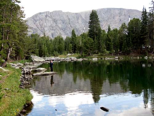
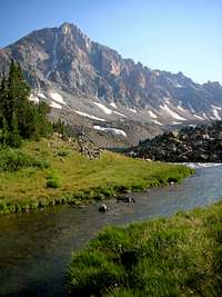
After waking up for our first day in Montana, we stopped at the ranger station in Red Lodge for some snow condition updates. It was a cloudy morning and the trip started out a little dreary but that didn't stop us from checking out the town of Red Lodge. This is one place I can live in for sure! What an amazing town it had everything you could ask for. Well we were on our way and our first place to go was the West Fork of Rock Creek Trailhead. We parked and began hiking up the West Fork Rock Creek trail around noon. Six miles from the trailhead we reached Quinnebaugh Meadows where we had our first views of the Whitetail Couloir and we were astounded. To our relief it was still snow filled. We had been worried we were too late. Since thunderstorms were beginning to darken the sky we decided to pitch camp off the trail in some trees and managed to get the tent up just before it started to downpour. Our first day in the Beartooth Mountains was looking like an omen as it rained all afternoon and we slept it out. As evening came the rains settled and we emerged to cook dinner. With the outlet stream for Dude Lake close by, we had plenty of water. We decided to climb Bowback Mountain the following day which would be the first 12er we would do. On the hike in, we noticed a large snowfield leading up towards Bowback Mountain and knew we needed to take advantage of it. After dinner we went back to sleep and set an early alarm.

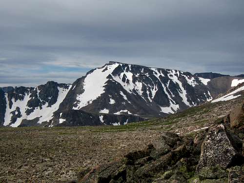
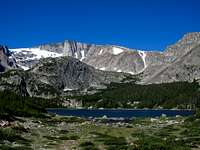
The first summit day I was so excited so getting out of the tent was easy. We started up "Dude Creek" which is what I decided to name this creek which drains Dude Lake just east of Bowback Mountain. The West Fork Trail crosses this creek on the first well constructed culvert bridge you come to from the trailhead. We took a short boot path following near the creek but it quickly ended and we continued up open forests and talus slopes reaching a nice waterfall just below the lake. We didn't continue to the lake but instead continued up a side valley just to the south and up the snowfield we saw earlier. This 40 degree snowfield ascended 1000 feet and ended below a small ridge north of Point 11,687. By this point it was late morning and a continuous layer of clouds lie above us. They didn't look bad so we continued west across a very broad plateau and ascending gently towards the north ridge. Once on the false northern summit of Bowback we descended off to the west and made the east class 2+ traverse to the higher southern summit. We found no register but I was ecstatic to have my first summit in the state of Montana. The weather was starting to clear a bit and from the top we saw Sundance Mountain dominate the south and the Granite Peak massif off to the west. The valley off to the east lie over 6,000 feet below and way off in the distance we spotted Red Lodge.
|
|
|

We admired the summit but knew we had to continue since I noticed darker clouds moving in from the southwest. I had documented the first route of the whole trip, the north ridge of Bowback Mountain and now the plan was to descend the south ridge. So we continued south and dropped off the ridge to the west when we came to a steep tower and headed down a loose gully and traversed below the crest for quite awhile on loose class 3 rock crossing one rib and gully after another until the terrain eased and we were able to walk on the ridge crest again. After dropping down one 15 foot step we reached the Bowback/Sundance saddle. I quickly made note of the remaining traverse to Sundance Mountain by ascending a couple hundred feet to view the remaining difficulties then we made our way down the east facing snowfield from the saddle back towards West Fork Rock Creek. We glissaded 800 feet of great snow which would be our first of many glissades on the trip. Once at the bottom of the snow we continued down the valley which had many large lakes including Triangle Lake and Kookoo Lake which both had lots of fish.
|
|
|
By this point it had started raining and we put rain gear on. However it quickly cleared and we had some amazing views of Silver Run Peak from the outlet of Kookoo Lake. We descended the steep creek draining Kookoo Lake as the weather continued to improve. We reached treeling and began to get wer from all the water on the grass and trees. Fantastic views of Whitetail were visible and we finally reached the trail once again a little over a mile up from where we left it that morning. A short walk brought us back to the tent where we cooked a nice big meal and went right to sleep. Our first day in Montana was in the books and we racked up 20 solid miles and off to a great start.
|
|
|
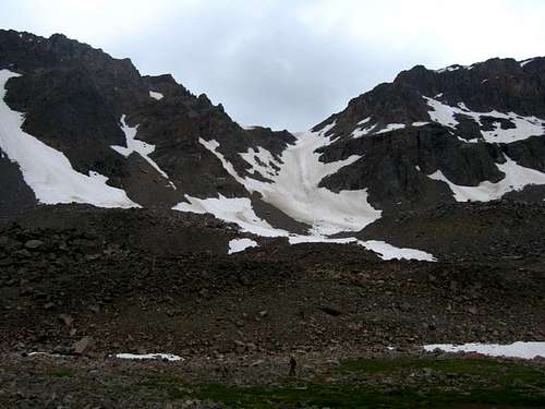
The next day we woke to a beautiful crisp morning and continued hiking the rest of the way up the trail to the bridge crossing over the West Fork. Continuing on the trail from here leads up many switchbacks to Sundance Pass but we continued further up the valley to a beautiful meadow camp spot next to Shadow Lake which was in a spectacular alpine setting right at the base of the Whitetail Couloir. Since we got a late start it was already about 10am by the time we set up camp and dried everything out. I decided I would climb the south slopes of Sundance Mountain later and rest for a few hours in the nice warm sunshine. We met a couple hiking up who was also planning to climb the Whitetail Couloir the next day but after we said we planned to they switched their plans to the NE couloir of Castle. We agreed to exchance conditions information about each couloir the next night and they were off to the next small lake to camp.
|
|
|

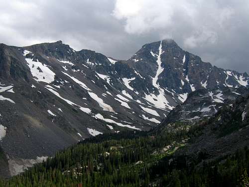
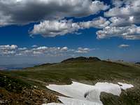
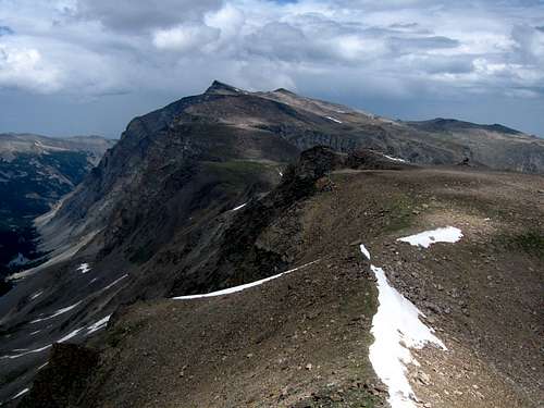
Around one in the afternoon I began hiking myself up the valley to the Silt Lakes. Stephan decided to sit this one out. Just above the upper Silt Lake I spotted a nice gully leading up Sundance Mountain and began ascending it trying to avoid loose rocks. I skirted up and through some cliff bands and headed directly for the summit cliffs of Sundance Mountain. Steering to the left of the cliffs above me I traversed around and fount a third class route up to the summit plateau. Right as I crested the plateau the winds picked up speed at an exponential rate but since it wasn't too cold I simply enjoyed the views and walked on almost flat terrain to the highest point at the far eastern edge. Views west towards Castle Mountain and its stunning NE couloir were amazing. I noticed a large crack about a quarter way up making the climb a little trickier. I was excited to think we might climb this snow route the day after Whitetail. Once I had my fill of great views I noticed a batch of dark clouds rolling in so I began descending. At first I couldn't find where I reached the plateau because my cairn I made blew over but I finally found my route and descended all the way down to the Silt Lakes with a brief shower which stalled me momentarily. I met up with a nice group of people coming down Castle from Omega Pass as I continued down the valley back to camp at Shadow Lake.
|
|
|
|
|

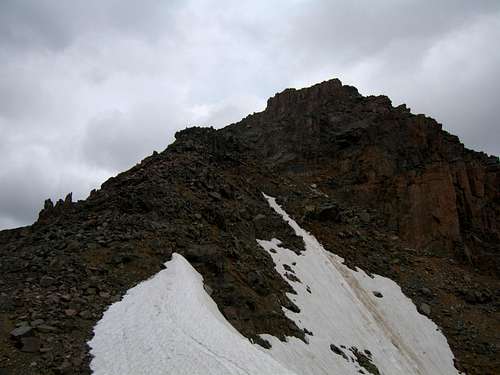
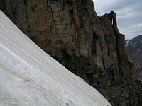
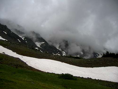
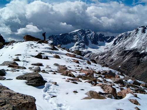
We made a very nice dinner and went right to sleep. We had the Whitetail Couloir ahead of us for the next day and I was very excited but a little nervous since I had never been on snow quite as steep and sustained before. This is why I hauled my plastic boots all the way up there however. The next morning which was July 17th we quickly began hiking up the valley and right before reaching the Silt Lakes we crossed the creek on some rocks and began hiking a small talus slope until we hit the snow. We changed our shoes, put the crampons on and retrieved our ice axes and began up the moderate snow at first but once we made that slight right turn into the couloir proper it steepened to 50 degrees and never relented. We began simul-climbing using pickets as anchors just to be safe. To my astonishment I noticed someone was crazy enough to glissade down the couloir. I admit I am one crazy person when it comes to glissades but this was a little too steep for my bones. About 60 feet from the top of the couloir we hit bullet ice. Stephan only had aluminum crampons and neither of us had second tools or any ice screws so we were forced to retreat off the snow onto the rock. Luckily the rock was just broken enough to scramble up to the summit on steep steps where a fall wasn't an option. We both managed to summit and felt very accomplished. That was the steepest snow line I have ever climbed and topping it off with a great and challenging scramble was icing on the cake. We sent quite some time on this nice peak which had views in every direction. We admired and looked to our future as we saw many of the 12ers we were going to climb. What a beautiful and inspiring place this was. Noticing clouds coming in from the southwest (this would be all too common) we began descending down the easy northeast ridge standard route to Sundance Pass. This was a simple but rocky hike where we got rained on heavily just as we reached the pass. Since we heard thunder we waited out the storm near the pass before making the hike down the 100 switchbacks back to Shadow Lake. Just as we reached the tent it really started to downpour on us. The clouds just gobbled up the mountains and it rained for hours the rest of the day.
|
|
|
|
|

We simply went to sleep as it rained for hours. Knowing how icy the top of the Whitetail Couloir was and adding to that all the rain that just fell, we decided against climbing the NE couloir on Castle Mountain knowing it would only get worse. After the rains let up we emerged to a very cool evening which prompted a quick dinner and a nice long rest. The next day was nice and sunny and we took our sweet time getting up and going to try and dry everything out. The 8 mile hike back to the car ended up being very nice due to all the nice people we talked to on the way out. Only one party of the 8 or 9 parties we saw were headed in to climb though. Once back at the car we went back to Red Lodge for a big pizza at the Red Lodge Pizza Company and returned back to the Timberline Creek Trailhead on the same road to climb Silver Run Peak as a day hike. We slept at the trailhead.
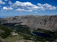
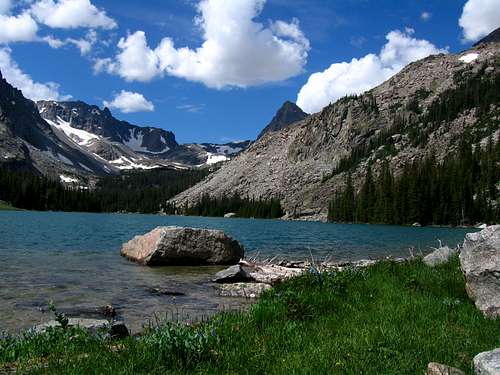
Knowing all about the southwest ridge route on Silver Run Peak in addition to how easy it was and the fact we were stormed off Sundance Pass before getting a chance to do Silver Run Peak we decided to take a different approach. We would climb Silver Run from Timberline Creek which is a 16 mile day hike. We started up the heavily burned Timberline Creek Trail and reached Timberline Lake by mid-morning. The massive pillar of rock seen at the head of the valley was inspiring to say the least. Only later afte reading more of Turiano's book did I find out this face had actually been climbed but at the time I wasn't sure. We hiked around the lake and climbed up easy slopes to the plateau then walked across the massive top gaining altitude ever slowly until we reached the summit marked by two USGS markers and a register. However the USGS had the true summit of Silver Run Peak misplaced on their maps. The true summit lies a half mile to the west so we ran over there as well. The return hike back over the plateau was a slog but the puffy clouds that had begun to form made the scenery just grand.
|
|
|
|
|

After we made it back to the car we headed back into town to visit a friend who offered us a place to stay if we ever needed during our time in Montana. We had a great dinner and recovered well and I started some writing from the notes I took while in the mountains.
Whitetail peak information
Overview
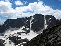
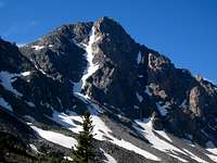
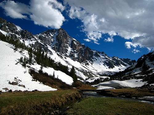
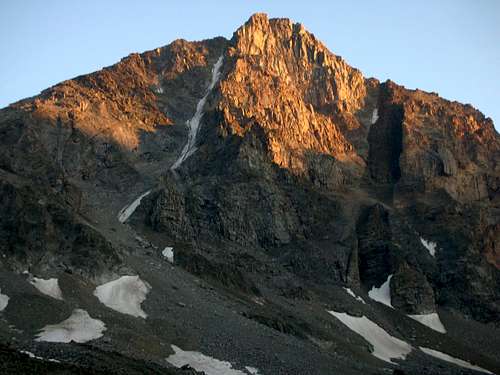
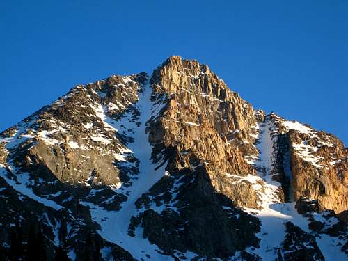
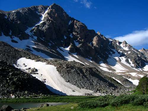
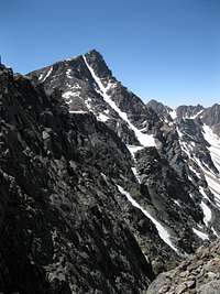
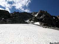
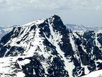
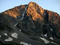
This aptly named peak is the fifth highest peak in Montana and certainly one of the best objectives in the state. Its name comes from the narrow but prominent snow and ice-filled couloir (50° sustained) that extends down from near the summit for over 2000 feet into the West Fork Rock Creek valley on the Northside of the mountain. Whitetail has the stereotypical mountain form, and from a distance, especially viewed from the north, can appear quite intimidating. The easiest route up the mountain is no more than a hike with a short amount of Class 3 scrambling. Due to its proximity to the Sundance Pass trail, Whitetail attracts a fair share of visitors and is a popular summer destination for local weekend climbers.
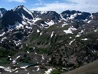
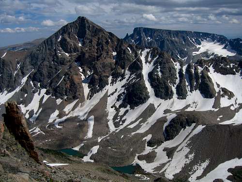
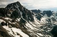
From the summit of Whitetail, one can get a great sense of the immense power that glaciation can have. The huge U-shaped valleys and big cliffs that were carved out of the massive Beartooth plateau have shaped the range to the dramatic and beautiful mountains we see today. Permanent snowfields still cling to the base of Castle Mountain at the head of West Rock Creek valley three miles to the West and if one were to look closely, some large Bergschrunds can still be found. Filling the valley floor below are the rock-strewn glacial moraines which make the approach for nearby Castle Mountain so formidable. Three miles to the south across another U-shaped valley one has a fantastic view of Beartooth Mountain itself, and just to the southwest extends a fantastic ridgeline that includes Medicine and Sky Pilot Mountains.
There are many potential routes on Whitetail Peak however two of them are by far the most commonly done. The Whitetail Couloir and Northeast Ridge are the main routes however one can conceivably climb directly up the south face or even climb one of the features to the west of the couloir on the north face. The couloir is also an excellent ski descent that avid skiers will try their skills on. With all this, Whitetail Peak is probably one of the most sought after and well-known peaks in Montana.
 Whitetail Peak and its namesake couloir Whitetail Peak and its namesake couloir |
 Whitetail at Sunset Whitetail at Sunset |
 The NW face of Whitetail The NW face of Whitetail |
Getting There
Trailheads
West Fork Rock Creek Trailhead
This is one of the more popular trailheads in the Beartooth Mountains and offers fantastic scenery. From the center of Red Lodge at the MT 308 and US 212 junction, head west 0.3 miles on US 212 and turn right onto the West Fork Road with signs for the Red Lodge ski area and measure distances from this turnoff. The road immediately comes to a Y, stay left and head up the paved road passing the Palisades Campground Road (gravel) on the right after 1.1 miles. Continue and enter the Custer National Forest after 2.8 miles and turn left to stay on the West Fork Road at 2.9 miles. Taking a right at this turnoff takes you to the ski area. Pass the winter closure gate at 5.2 miles, the Basin Lake Campground at 7.2 miles and the road turns to gravel at 7.4 miles. At mile 10.5, pass the Cascade Campground and reach the trailhead at mile 13 with an elevation of 7,890 feet. Here there is room for about 40 cars and 7 horse trailers and a pit toilet is available.
Lake Fork Rock Creek Trailhead
From the Montana State 308 and US Highway 212 junction in Red Lodge, go 10.8 miles west on US 212 towards Beartooth Pass and turn right onto the Lake Fork Road. Go 1.8 miles on this paved road to its end at the trailhead with ample parking. The elevation at this trailhead is 7200 feet.
Approaches
West Fork Appeoach
From the West Fork Rock Creek trailhead, start up the trail and take an immediate left with a sign for Quinnebaugh Meadows and Sundance Lake. Follow this trail for two miles through a burn area and reach the small Sentinel Falls at 8,400 feet just past a couple switchbacks. Continue up the more forested trail another 2.2 miles to Quinnebaugh Meadow and the junction with the Lake Mary Trail. The meadow offers fantastic camping and the first views of Whitetail Peak. Continue straight and cross the stream draining Lake Mary on a series of small logs or rocks and reach the first culvert bridge 0.6 mile past the Lake Mary junction at 8,950 feet. At this bridge a short boot path heads up this side drainage towards Senal and Dude Lakes. From here, continue up the flat and well groomed trail for 1.2 miles to a second culvert bridge that crosses Kookoo creek which drains Kookoo Lake. Beyond this point the trail steepens for the next 1.6 miles and climbs 500 feet over a series of switchbacks to a very nice footbridge crossing the West Fork Rock Creek to its SW side.
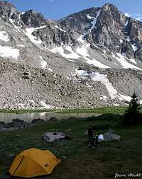
From this footbridge, you can either camp right next to it on the small grassy bench or continue up the main valley without crossing the footbridge on the creeks NW side over talus and grass for 0.4 mile to Shadow Lake. Excellent camping can also be found at Shadow Lake but don't expect sun in the afternoon...it's called Shadow Lake for a reason.
RT Distance:From trailhead to camp at Quinnebaugh Meadow – 8.4 milesFrom trailhead to Sundance Pass – 21.2 milesFrom trailhead to Shadow Lake – 16 milesRT Elevation Gain:From trailhead to camp at Quinnebaugh Meadow – 1000 feetFrom trailhead to Sundance Pass – 3,050 feetFrom trailhead to Shadow Lake – 1,610 feet
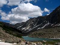
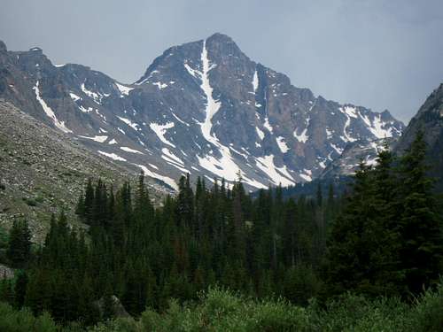 Whitetail Peak from Quinnebaugh Meadows Whitetail Peak from Quinnebaugh Meadows |
 Shadow Lake Shadow Lake |
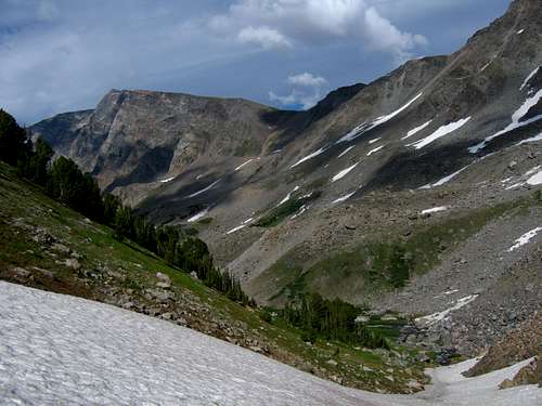 Looking down the valley Looking down the valley |
Lake Fork Approach
Approaching from the Lake Fork isn't as scenic but is commonly done for Whitetail Peak. This approach is only feasible for the standard NE ridge route though as the Whitetail Couloir route doesn't start from Sundance Pass, where both approaches meet but instead starts just above Shadow Lake. However, the Lake Fork Trail is much more forested and views are harder to come by. From the Lake Fork Trailhead, follow the trail along the south side of the creek for 4.7 miles to the junction with the Lost Lake trail. This spur trail leads 0.2 miles to Lost Lake with good camping, but poor fishing. Lost Lake sees a lot of day hikers so don’t expect much solitude here. Continue past the junction 0.3 miles to the nice foot bridge crossing the Lake Fork at 8440 feet.
Once on the north side of the Lake Fork, continue up the trail a short ways to a signed junction just before the trail begins traversing steeply above the Lake Fork. Heading down and to the left at this junction is a small side trail leading down to Keyser Brown Lake. Great camping and fishing is found here and an assortment of boot paths and game trails leads further to the turquoise colored First and Second Rock Lakes. For the adventurous hikers, you can continue to the head of the Lake Fork drainage passing below the north face of Beartooth Mountain, and reaching Sky Pilot Lake after a long day of bushwhacking and talus hiking. The south ridge of Sky Pilot Mountain can be reached via Sky Pilot Lake.
Although not thoroughly described on this page, one can also climb the south face of Whitetail Peak starting from a point about a mile past the west end of Second Rock Lake. At a 100 foot cascade in the Lake Fork at 9,600 feet in elevation, begin ascending north through the trees passing around a small 10,540 foot knob. Once past this knob, continue directly up the south slopes staying close to the crest of the broad ridge. Views to the east down the Lake Fork are stunning and to the west the daunting east face of Sky Pilot Mountain inspire all outdoor enthusiasts. Note that the ascent up the south side is a steep talus hike with interspersed scrambling on loose rock. Reach the same notch at the top of the Whitetail Couloir and continue the final scramble to the summit.
For the standard NE Ridge route though, continue up the trail as it traverses above the Lake Fork to September Morn Lake, continue a couple more miles to Sundance Pass and take a nice break and enjoy the views before finishing the climb.
RT Distance:From trailhead to September Morn Lake – 15 milesFrom trailhead to Sundance Pass – 20 miles
 September Morn Lake September Morn Lake |
 Second Rock Lake Second Rock Lake |
Route Options
Northeast Ridge Standard Route - Class 3
Use either the West Fork Rock Creek or the Lake Fork approach and hike to Sundance Pass. Although this is one of the possible summit day hikes in the Beartooth Mountains, it is best to make camp at either Quinnebaugh Meadow or Shadow Lake. From Sundance Pass, hike southwest up the ridge staying to the left (south) side of a narrow section of ridge just above the pass. Beyond this, hike up easy talus to 11,250 where a small rock tower can be seen. Contour to the east of the summit of Mount Lockhart and to the west of the rock tower on flat terrain and descend 100 feet to the 11,570 foot saddle between Lockhart and Whitetail 1.4 miles from Sundance Pass. From this saddle, climb 0.5 mile on steepening talus (Class 2) for 800 feet and reach the top of the north couloir route at 12,400 feet. Cross the small saddle and climb the initial 15 foot wall (Class 3). Scramble west for 150 feet on the northeast ridge to the summit. There are many cairns on this route. Descend the ascent route. This route is a 25 mile round-trip hike from the trailhead so be prepared for a long day.
 On the NE Ridge route On the NE Ridge route |
 The NE Ridge route from the summit The NE Ridge route from the summit |
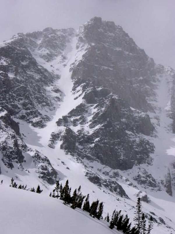
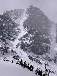
Whitetail Couloir - Class 3 and Steep Snow
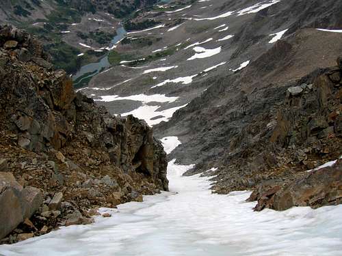
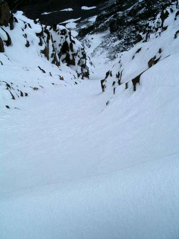
Use the West Fork Rock Creek approach and set up camp at Shadow Lake. Hike to the southwest end of the lake and cross the stream on talus where the water flows below the rocks. Turn left (south) and hike up talus aiming for the long narrow couloir cutting deep into Whitetail Peak. The talus slope eases at 9,850 and the snow will likely start here, if not sooner. Climb moderate (35-40 degree) snow and enter the couloir proper at 10,800 feet where it curves to the right. Continue up as the slope steepens to 45 degrees at 11,000 feet, then up to 50 degrees at 11,700 feet. There is a nice place to rest to the left edge on rock here. A running belay using rope and pickets is recommended for the final 700 feet. In late season, the upper part becomes icy which could be a problem for unprepared parties. Check the conditions of this couloir before climbing. Reach the top at a 12,400 foot small saddle and climb the initial 15 foot wall out of the saddle (Class 3). Scramble west for 150 feet on the northeast ridge to the summit. Descend the northeast ridge route. This climb takes about 5 hours from camp to the summit.
RT Distance:From Shadow Lake with descent of northeast ridge – 7.1 milesFrom trailhead with descent of northeast ridge – 23.1 milesOne way distance from Shadow Lake – 2.1 miles
RT Elevation Gain:From Shadow Lake with descent of northeast ridge – 3,000 feetFrom trailhead with descent of northeast ridge – 4,700 feet
 Whitetail Couloir Whitetail Couloir |
 Looking down the couloir from the top Looking down the couloir from the top |
Map
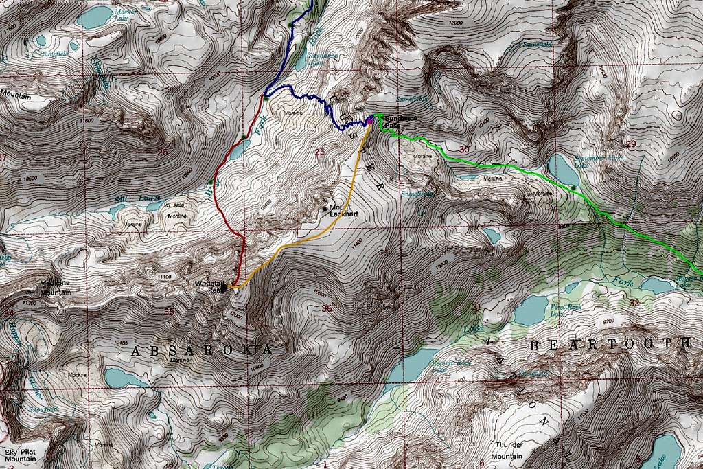
BLUE: West Fork Rock Creek Approach - Class 1
GREEN: Lake Fork Rock Creek Approach - Class 1
ORANGE: Northeast Ridge Route - Class 3
RED: Whitetail Couloir Route - Class 3 and Steep Snow
Green Dots: Camping Spots
Purple Dot: Sundance Pass
Note the south face route isn't drawn but is visible between the "O" and the "K" in Absaroka
Camping/Red Tape
Camping is allowed anywhere within the Absaroka-Beartooth Wilderness. You are "requested" to check in with the Beartooth Ranger Station in Red Lodge or call (406) 446-2103 before camping. You must have a permit to cut live trees for firewood. Most parties choose to climb Whitetail in two days, camping either at the base of Sundance Pass by the foot bridge on the West Fork trail, or at September Morn Lake on the Lake Fork approach. Remember to practice Leave No Trace, and as always in bear country, hang your food well away from camp at night and carry bear spray.
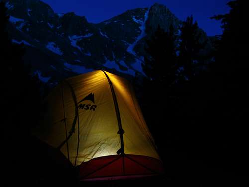 Whitetail Peak camp
When to Climb
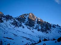
Spring: For ascents from April through June, the weather can be very unpredictable and snow can fall during any ordinary storm. Be prepared for cold and windy conditions. Despite this, fantastic weather can be found and offers beautiful alpine scenery. This is the prime time to ski the Whitetail Couloir if this is your goal. People often skin up the valley and climb the couloir while carrying skis then ride down. This line is for expert skiers only and has caused serious injuries to some who have failed on the descent. Gear needed for the climb are mountaineering boots, crampons, three pickets, alpine rope and harness and an ice axe. If you are confident on 50-degree snow some parties do free solo the climb.
Summer: Summer ascents of Whitetail Peak can vary a lot depending on the previous winters' snow-pack. The best time to climb it is July through early September. For the couloir, usually by August much of it is too icy to be climbed simply with crampons, pickets and one ice axe but this doesn't deter some of the most avid climbers from ascending during late summer. Ice climbers who are prepared with ice screws, two axes, steel crampons can make the ascent in August but by the time September rolls around, the couloir begins drying out and it is best avoided altogether.
Fall: From September through December, fall snows begin to accumulate making scrambling more tedious. Windstorms begin making ascents more brutal. The Northeast Ridge route is the best option in the fall due to loose rocks and lack of firm snow in the couloir.
Winter: This peak is somewhat of an expedition-style climb from January through March with harsh weather and very large avalanches common. The route isn't recommended except when the snow-pack is very stable. Add the very long approach, skis may be required.
 Whitetail Peak in nice summer conditions Whitetail Peak in nice summer conditions |
 Whitetail Peak in early spring Whitetail Peak in early spring |
External Links
whitetail couloir beta
Overview
The Whitetail Couloir is one of the premier mountaineering routes in all of Montana and certainly one of the best lines in the state. Located on the namesake mountain it rises to the summit at 12,551 feet. This is the fifth highest peak in the state and this route is the way to go! From the summit of Whitetail Peak one can see the power of the glaciers that carved the Beartooths into their present form. Permanent snowfields still cling to the base of Castle Mountain at the head of West Rock Creek valley. Filling the valley floor below are very large boulders and glacial moraines making for an awe inspiring sight. Three miles to the south across another U-shaped valley one has a fantastic view of Beartooth Mountain itself, and towards the south and west extends a long jagged ridgeline that includes Medicine and Sky Pilot Mountains. A climb of the Whitetail Couloir can be a very rewarding and satisfying experience or a horrific tale of survival depending on conditions, experience and weather. This route is not to be taken lightly and proper experience in steep snow climbing is imperative for a safe and successful ascent.
|
Whitetail Couloir from Quinnebaugh Meadows |
Whitetail Couloir from Shadow Lake |
 Whitetail in May Whitetail in May |
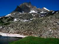
 Whitetail Peak Whitetail Peak |
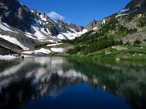
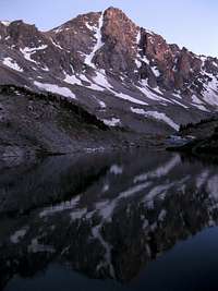 Whitetail Peak reflection Whitetail Peak reflection |
 Whitetail from Mt Lockhart Whitetail from Mt Lockhart |
 Camping at Shadow Lake Camping at Shadow Lake |
Getting There
For this route, access comes from the West Fork Rock Creek Trailhead located just outside Red Lodge, Montana. This is one of the more popular trailheads in the Beartooth Mountains and offers fantastic scenery. From the center of Red Lodge at the MT 308 and US 212 junction, head west 0.3 miles on US 212 and turn right onto the West Fork Road with signs for the Red Lodge ski area and measure distances from this turnoff. The road immediately comes to a Y, stay left and head up the paved road passing the Palisades Campground Road (gravel) on the right after 1.1 miles. Continue and enter the Custer National Forest after 2.8 miles and turn left to stay on the West Fork Road at 2.9 miles. Taking a right at this turnoff takes you to the ski area. Pass the winter closure gate at 5.2 miles, the Basin Lake Campground at 7.2 miles and the road turns to gravel at 7.4 miles. At mile 10.5, pass the Cascade Campground and reach the trailhead at mile 13 with an elevation of 7,890 feet. Here there is room for about 40 cars and 7 horse trailers and a pit toilet is available. From the West Fork Rock Creek trailhead, start up the trail and take an immediate left with a sign for Quinnebaugh Meadows and Sundance Lake. Follow this nice trail for two miles through a burn area and reach the small Sentinel Falls at 8,400 feet just past a couple switchbacks. Continue up the more forested trail another 2.2 miles to Quinnebaugh Meadow and the junction with the Lake Mary Trail. The meadow offers fantastic camping and the first views of Whitetail Peak. Continue straight and cross the stream draining Lake Mary on a series of small logs or rocks and reach the first culvert bridge 0.6 mile past the Lake Mary junction at 8,950 feet. At this bridge a short boot path heads up this side drainage towards Senal and Dude Lakes. From here, continue up the flat and well groomed trail for 1.2 miles to a second culvert bridge that crosses Kookoo creek which drains Kookoo Lake. Beyond this point the trail steepens for the next 1.6 miles and climbs 500 feet over a series of switchbacks to a very nice footbridge crossing the West Fork Rock Creek to its SW side. Rather than crossing this bridge and continuing up the trail to Sundance Pass, continue up the valley on the left side to Shadow Lake which makes a great place to camp. It is advised to approach on this trail and camp so you can get an early start on the couloir.
|
Shadow Lake morning reflection |
Looking down the West Fork |
Route Description
From camp at Shadow Lake, or shortly beyond, find a place to cross the creek either rock hopping, snow bridge or wading. Aim for the base of the obvious Whitetail Couloir and climb a short talus moraine to wherever snow begins. In June and early July the entire area will most likely be snow covered. Later in July the moraines near the base will melt out leaving some unpleasant talus to climb. Climb moderate (35-40 degree) snow above the moraine and enter the couloir proper at 10,800 feet where it curves to the right. Continue up as the slope steepens to 45 degrees at 11,000 feet, then up to 50 degrees at 11,700 feet. There is a nice place to rest to the left edge on rock here. A running belay using rope and pickets is recommended for the final 700 feet. In late season (mid-July onward), the upper part becomes icy which could be a problem for unprepared parties. Check the conditions of this couloir before climbing and bring proper gear. Reach the top at a 12,400 foot small saddle and climb the initial 15 foot wall out of the saddle (Class 3). Scramble west for 150 feet on the northeast ridge to the summit. If the upper 50-100 feet of the couloir is icy and you are not equipped to climb ice, you can leave the snow to the climbers right and scramble up difficult 4th class rock to the NE ridge. Extra care should be taken though since these north face rocks are steep and loose. Descend the northeast ridge route and descend the obnoxious switchbacks from Sundance Pass back to the creek and cross the bridge back to your tent.
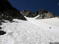 Looking up the couloir Looking up the couloir |
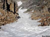 Looking down the couloir Looking down the couloir |
 Looking across the couloir Looking across the couloir |
 Climbing the moraine at the base Climbing the moraine at the base |
Essential Gear and When to Climb
Spring:For ascents from April through June, the weather can be very unpredictable and snow can fall during any ordinary storm. Be prepared for cold and windy conditions. Despite this, fantastic weather can be found and offers beautiful alpine scenery. This is the prime time to ski the couloir if this is your goal. People often skin up the valley and climb the couloir while carrying skis then ride down. This line is for expert skiers only and has caused serious injuries to some who have failed on the descent. Gear needed for the climb are mountaineering boots, crampons, three pickets, alpine rope and harness and an ice axe. If you are confident on 50 degree snow some parties do free solo the climb.
Summer:Summer ascents of the Whitetail Couloir can very a lot depending on the previous winters' snow-pack. The best time to climb it is early to middle July but beyond this the top begins to ice over. usually by August, much of the couloir is too icy to be climbed simply with crampons, pickets and one ice axe but this doesn't deter some of the most avid climbers from ascending during late summer. Ice climbers who are prepared with ice screws, two axes, steel crampons can make the ascent in August but by the time September rolls around, the couloir begins drying out and it is best avoided all together.
Fall:From September through December this route is best avoided. The Northeast Ridge route is a much better option.
Winter:This route would be closer to an expedition style climb from January through March with harsh weather and very large avalanches common. The route isn't recommended except when the snow-pack is very stable.
 Whitetail from Sundance Pass Whitetail from Sundance Pass |
 Whitetail Peak in early June Whitetail Peak in early June |
 Whitetail in late July Whitetail in late July |
 The couloir in April The couloir in April |
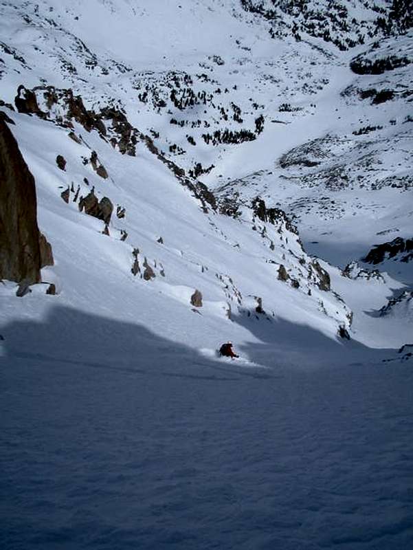 Skiing the Whitetail Couloir Skiing the Whitetail Couloir |
 Looking down the couloir after an August snowstorm Looking down the couloir after an August snowstorm |
External Links
See This page for a good trip report of a climb and ski of the couloir