LEMKE CLIMBS
  • About
    • Whats New
    • 2019 Goals/Wishlist
    • Contact
  • Washington
    • North Cascades >
      • Sahale Peak, Boston Peak
      • Eldorado Peak, Klawatti Peak
      • Black Peak
      • Forbidden Peak West Ridge
      • Primus Peak Attempt
      • Big Snagtooth
      • Liberty Bell Beckey Route
      • Burgundy Spire North Face 5.8
      • Ragged Ridge - Katsuk, Kimtah and Cosho Peaks
      • Colfax Peak
      • South Early Winters Spire via SW Buttress
      • Chilliwack Mini-Slam
      • Mesahchie Peak
      • Inspiration Traverse
      • Mount Shuksan Ski
      • Full Pickets Traverse
      • Mount Goode NE Buttress & Storm King
      • Mount Baker North Ridge WI3
      • Snowfield Peak
      • Lincoln Peak
      • Silver Star Mountain
      • Mount Buckner & Horseshoe Peak
      • Azurite Peak
      • Tower Mountain & Golden Horn
      • Mount Logan
      • Custer Ridge & Easy Mox
      • Mazama Dome
      • Sherman Peak
      • Mount Ballard
      • Southern Pickets Traverse
      • Corteo Peak
      • Whatcom Peak
    • Glacier Peak Wilderness >
      • Buck Creek Pass, Cloudy Peak, Spider Gap
      • Dome Peak, Spire Point
      • Mt. Maude and Seven Fingered Jack
      • Mount Formidable NE Face 5.6 Second Ascent
      • Dumbell and Greenwood Mountains
      • Glacier Peak Wilderness Mountain Massacre
      • Clark and Luahna Peaks
      • Sinister Peak
      • Chiwawa Mountain
      • Tupshin & Devore Peaks
      • Buck & Fortress Mountains
      • Glacier Peak
      • Snowking Mountain
    • Olympic Peninsula >
      • Buckhorn Mountain
      • Flapjack Lakes Hike
      • Grey Wolf Peak, High Divide Trail
      • Mount Ellinor
      • Mount Constance West Arete
      • Mount Olympus
    • Alpine Lakes Wilderness >
      • Chikamin Peak
      • PCT - Snoqualmie to Pete Lake
      • Foss Lakes Hike
      • Necklace and Tank Lakes
      • Enchantments Day Hike
      • Granite Mountain (Snoqualmie)
      • Colchuck Peak
      • Cannon, Enchantment and Stuart
      • Ingalls Peaks
      • McClellan Peak
      • Dragontail Peak
      • Web Mountain
      • Mount Index Attempt
      • Snow Creek Wall Orbit 5.8+
      • The Tooth South Face
      • Eightmile Mountain
      • Argonaut Peak NE Couloir
      • Little Annapurna South Face 5.5
      • Snow Creek Wall Outer Space 5.9
      • Cashmere Mountain
      • Sherpa Peak North Ridge 5.8
      • Chair Peak NE Ridge
      • Lichtenburg Mountain
      • Mount Index
      • McClellan Butte
      • Chimney Rock
      • Alpine Lakes High Route
    • Pasayten Wilderness >
      • The Craggies
      • Tiffany Mountain
      • Pasayten Mini-Slam
      • Remmel Group
      • Jack Mountain
      • Robinson Mountain
      • Monument Peak Group
    • Mountain Loop Highway >
      • Vesper Peak
      • Mount Dickerman
      • Sloan Peak West Face 5.8
      • Mount Forgotten
      • Whitehorse Mountain
      • Gothic Peak
    • Lake Chelan Sawtooth Wilderness >
      • Star, Courtney, and Grey Peaks
      • Hoodoo Peak and Raven Ridge
      • Abernathy Peak
      • Mount Bigelow
      • Reynolds Peak
      • Oval Peak
      • Gardner Peaks
      • Chelan Sawtooth Trio
    • Southern WA >
      • Mount Adams
      • Mount Rainier - Emmons Route
      • Mount Saint Helens
      • Goat Peak
      • Lane Peak, Plummer Peak (Tatoosh)
      • The Unicorn (Tatoosh)
      • Little Tahoma
      • Liberty Cap
    • WA Rock and Ice Cragging >
      • Index Town Walls
      • Vantage
      • Mount Erie
      • Exit 38
      • Leavenworth
  • Colorado
    • San Juan Mountains >
      • Mount Sneffels Lavender Snow Climb
      • Uncompahgre, Matterhorn Peaks
      • Redcloud, Sunshine Peaks
      • San Luis Peak
      • Vermilion, Fuller Peaks
      • Stewart Peak, Baldy Alto
      • Jones, Niagara, American Peaks
      • Wetterhorn Peak, Handies Peak
      • Wilson Group
      • Arrow Peak
      • Mount Sneffels SW Ridge
      • Jagged Mountain, Chicago Basin
      • Teakettle Mountain
      • Dallas Peak
      • Vestal Peak Wham Ridge, Greystone Peak
      • Organ Mountain
      • Phoenix Peak
      • Half Peak
      • Point 13832 Group
      • Golden Horn
      • Mount Sneffels Snake Couloir
      • Pigeon, Turret Peaks
    • Elk Mountains >
      • Four Pass Loop
      • Castle, Conundrum Peaks
      • Snowmass Mountain
      • Cathedral Peak
      • South Maroon Peak
      • The Pyramids
      • North Maroon Peak, Sleeping Sexton
      • Capitol Peak, Mount Daly
      • Malemute Peak
      • Hagerman Peak
    • Sangre de Cristo Mountains >
      • Blanca Peak, Ellingwood Point
      • Challenger Point
      • Mount Adams
      • Spread Eagle Peak
      • Humboldt, Obstruction, Columbia Peaks
      • Mount Lindsey, Huerfano Peak
      • Little Bear Peak
      • Crestone Needle Ellingwood Arete
      • California Peak
      • Crestone Peak North Buttress
      • Operation Dark Snake
      • Kit Carson Mountain
    • Sawatch Mountains >
      • Iowa Peak
      • Point 13,618 - Hunky Dory Lake
      • Gold Dust Peak, Notch Mountain
      • Mount Jackson
      • Mount Belford
      • Shavano, Tabeguache Peaks
      • Mount Antero, Cronin Peak
      • Twining Peak
      • Mount Massive
      • Casco Peak
      • Mount Huron
      • Mount Elbert
      • Mount Oxford
      • Mount Hope
      • Mount Yale
      • Lackawanna Peak
      • Mount Columbia
      • La Plata Peak
      • Rinker and Twin Peaks
      • Bull Hill, Mount Princeton
      • Missouri Mountain
      • Mount Oklahoma
      • French Mountain
      • Mount Ouray
      • Grizzly A, Garfield Peaks
      • Mount Harvard
      • The Three Apostles
      • Emerald Peak
      • Holy Cross
      • Mount Aetna
    • Greater Park Range >
      • Kneeknocker Pass, Piney Lake
      • Drift Peak
      • Sherman Peak, Dyer Peak
      • Gore Range Traverse
      • Quandary Peak
      • Pacific, Atlantic Peaks
      • Clark Peak
      • Crystal Peak, Peak 10
      • Fletcher Mountain
      • The DeCaLiBron
      • Loveland Mountain
      • The Mosquito Traverse
      • Mount Arkansas
      • Clinton Group
      • Eagles Nest, Peak C
      • North Star Mountain
      • Peak X
      • Wheeler Mountain
    • Front Range >
      • Mount Evans, Spalding
      • Mount Bierstadt
      • Mount Parnassus, Bard Peak
      • Cupid, Sniktau, Grizzly D Peaks
      • James Peak
      • Mount Silverheels
      • Grays and Torreys Peaks
      • Mount Edwards
      • Mount Flora, Longs Peak
      • Square Top Mountain
      • Petit Grepon South Face 5.8
      • Mount Meeker Dreamweaver Couloir
      • Santa Fe Peak
      • The Citadel & Pettingell
    • Colorado Ice Climbing >
      • Lincoln Ice Falls
      • Ouray Ice Park
      • Avocado Gully and The Drool
      • Hidden Falls
    • Colorado Rock Climbing >
      • Eldorado Canyon
      • The Flatirons
      • North Table Mountain
      • Shelf Road
      • Colorado National Monument >
        • Independence Monument
  • Wyoming
    • Wind River Mountains >
      • Gone With the Winds
      • Union Peak - Solar Eclipse
      • Wind River Peak
      • Wind River Slam
    • Teton Range >
      • Grand Teton Owen Spalding 5.4
      • Mount Owen Attempt
    • Wyoming Absarokas and Gros Ventre Range >
      • Jackson Peak
      • Francs Peak
    • Yellowstone National Park >
      • Top Notch Peak
    • Bighorn Range and Great Divide Basin >
      • Boars Tusk
      • Loaf Mountain
      • Cloud Peak
      • Black Tooth Mountain
    • Devils Tower
    • Cody Rock and Ice Climbing
  • Montana
    • Beartooth Mountains >
      • Whitetail Peak Group
      • Beartooth Mountain
      • Spirit Mountain Group
      • Mount Peal
      • Granite Peak Group
      • Castle Rock Group
      • Castle Mountain NE Couloir
      • Mount Inabnit and Sylvan Peak
      • Mount Hague South Slopes
      • Mount Villard and The Granite Peaks Traverse - 5.4
      • Spirit Mountain NE Ridge - 5.4
      • California Ice WI 4
      • The Ramp 5.8
      • Linea Alba 5.10d
      • Iceberg Peak
      • Metcalf Mountain North Rib 5.8
      • Villard Spires HP West Ramp
      • Cairn Mountain
      • Snowbank Mountain
      • Mount Wood Group
      • Bears Tooth
      • Glacier Peak Catch-a-Sunrise FA
    • Montana Absarokas & Gallatin Range >
      • Black Mountain
    • Southwest Montana Ranges >
      • Sacajawea Peak
      • Arrow Peak
      • Koch Peak
      • Saddle Peak
      • Baldy Mountain
      • Sphinx Mountain
    • Glacier National Park >
      • A Taste of Glacier National Park
      • Divide Mountain
    • MT Rock and Ice Climbing
  • Utah
    • Uinta Mountains >
      • Kings-Emmons Ridge Run
      • Hayden Peak
      • Iron Hayden Wall Rock Climbing
    • Wasatch Range >
      • The Sundial Eleventh Hour 5.8
      • Mount Timpanogos
    • San Rafael Swell >
      • Ramp, Cistern Canyons
      • Salt Wash, Black Mountain, Moroni Slopes
      • Ding, Dang Canyons
      • Little Wild Horse, Bell Canyons
      • Quandary Canyon
      • San Rafael Knob
      • Miners Hollow (Knotted Rope Canyon)
      • Temple Mountain
      • Chimney Rock
      • Bottleneck Mesa
      • Window Blind Peak
      • Lower Baptist Draw & Upper Chute Canyon
    • Capitol Reef National Park >
      • Cathedral Valley Tour
      • Sheets Gulch
      • Halls Creek Narrows
      • Brimhall Canyon and Strike Valley Overlook
      • George Benchmark
    • Moab Area, Canyonlands, Arches >
      • Maze District
      • Needles District
      • Maze District
      • White Rim Trail Biking
      • Elephant Butte, Bullwinkle Tower and Lizard Rock
      • South Six Shooter
      • Elephant Canyon
      • Parriott Mesa
      • Ancient Art
      • Castleton Tower North Chimney 5.8
      • Klondike Bluffs
      • Mount Peale & Tukuhnikivatz
    • Robbers Roost Country >
      • Horseshoe Canyon, Goblin Valley
      • Bluejohn Canyon
      • Happy Canyon Narrows
      • Shenanigans, Leprechaun Slots
      • Larry Canyon
      • Merry Piglet Slot
      • Lower Maidenwater Canyon, Turkey Knob
      • Morocco Canyon
      • Monkey Business Slot
      • Hog Canyon Slots
      • Upper Maidenwater Canyon Slots
      • Mount Ellen
      • Buck Canyon
      • Point 4906
      • Alcatraz Canyon
      • Hard Day Harvey Slot
      • Mount Ellsworth
      • Good Day Jim Canyon
      • White Roost Canyon
      • Upper Stair Canyon
      • Dragon Canyon
    • Escalante National Monument >
      • Phipps Canyon and Arch
      • Red Breaks Slot
      • Dry Fork Slots, Coyote Gulch
      • Little Death Hollow/Wolverine Canyons
      • Egypt 3 Slot
      • Egypt 1 Canyon
    • Zion/Bryce >
      • Ataxia Tower Ashtar Command 5.9
      • Mount Kinesava Cowboy Ridge
      • Birch Hollow
      • Aires Butte
      • West Temple
      • Mystery Canyon
      • Crazy Streak
    • Cedar Mesa Region/Valley of the Gods >
      • Eagle Plume Tower Eagle Feather 5.10b
  • California
    • High Sierras, Southern CA Ranges >
      • Telescope Peak, Manly Beacon
      • Tahquitz Rock Whodunit 5.9
      • Tahquitz Rock Long Route 5.9
      • Palisade Traverse
      • White Mountain
    • Yosemite National Park, Central CA
    • Northern CA Cascades >
      • Lava Beds National Monument
      • Mount Shasta
  • Oregon
    • Oregon Volcanoes >
      • Three Fingered Jack
      • Mount Scott
    • Blue Mountains >
      • Twin Peaks
    • Trout Creek Rock Climbing
  • Alaska
    • Eagle Peak and Mount Ewe
    • Jatt Peak and Portage Pass
    • Rainbow Peak
    • Mount Brooks Attempt
    • Arrigetch Peaks Trek
    • Ab Mountain Hike
    • South Suicide Peak
    • Mount Hunter West Ridge Attempt
    • Cantata Peak Attempt
    • East Twin Peak
    • Mount Alice
    • Crow Pass and Hope Point Hikes
    • Indianhouse Mountain Attempt
    • Lynx Peak
    • Harding Icefield Hike
    • Hatcher Pass and Grapefruit Rocks Climbing
    • Mount Sanford
    • Mount Hunter West Ridge
  • Nevada
    • Ginger Cracks 5.8
    • Mescalito Dark Shadows 5.8
    • Birdland and Olive Oil
    • Frogland 5.8
    • Johnny Vegas 5.8
    • Schaeffer's Delight & Triassic Sands
    • Solar Slab - 5.6
  • British Columbia
    • Mount Matier
    • Taiya Peak
    • Bugaboo Spire NE Ridge
    • Mount Sabine Easy Honey 5.10b
    • Mount Sir Donald NW Ridge Attempt
    • Black Tusk
    • Squamish Ticks
    • Slesse Mountain NE Buttress
    • Warden Peak
    • Triple Peak
  • Alberta
    • Mist Ridge Hike
    • Mount Temple Attempt
    • East Wendell Peak
    • Loder Peak
    • Tower Mountain Attempt
    • The Rimwall
    • Mount Yamnuska Directissima 5.9
    • Mount Lawrence Grassi
    • Mount Lorette
    • Roche A Perdrix
    • Mount Edith Cavell East Ridge 5.3
    • Mount Louis Kain Route
    • Eiffel Peak
    • Canadian Rockies Ice Climbing
  • Other States
    • Arizona >
      • Grand Canyon Bright Angel Trail
      • Beanfest at Cochise Stronghold
      • Baboquivari Peak
      • Humphreys Peak
    • New Mexico >
      • Philmont Trek August 2008
    • Yukon >
      • Canyon Peak
  • International
    • Mexico & Central America >
      • Mexico - Pico de Orizaba, Izta
      • Guatemala Volcanoes
    • South America >
      • An Introduction to Patagonia
      • Cordillera Blanca - Tocllaraju and Urus
      • Nahuel Huapi National Park & The Frey
      • Exploring Pucon and Lanin Volcano
      • Cordillera Blanca - Ishinca Peak and Artesonraju
      • Cordillera Blanca - Quitaraju & Alpamayo
      • Exploring Southern Peru
      • Cerro Helio Azul & Tronador Attempt
      • Aguja Guillaumet Amy Couloir
      • Cerro Puntado & Palo
      • Cerro Colorado
      • Cerro Puno & Agudo
      • Cerro Trinidad Attempt
      • Volcan Quetrupillan
      • Cerro Placas
      • Nevado de Acay
      • Pequeno Alpamayo
      • Huayna Potosi
      • Illimani
      • Chiaro de Luna
      • Cerro Barros Arana
    • Oceania >
      • Exploring New Zealand's South Island
      • Puncak Jaya
      • Mount McPherson and Talbot
      • Single Cone
      • Mount Cook
      • Mount Aspiring
      • Manakau
    • Central Asia >
      • Kyrgyzstan 2021
  • Sorted by Year
    • 2008 Trip Reports
    • 2009 Trip Reports
    • 2010 Trip Reports
    • 2011 Trip Reports
    • 2012 Trip Reports
    • 2013 Trip Reports
    • 2014 Trip Reports
    • 2015 Trip Reports
    • 2016 Trip Reports
    • 2017 Trip Reports
    • 2018 Trip Reports
    • 2019 Trip Reports
    • 2020 Trip Reports
    • 2021 Trip Reports
    • 2022 Trip Reports
  • Vanlife
    • Conversion Journal >
      • Floor Installation
      • Folding Bed
      • Coffee Table
      • Thinsulate Installation
      • The Couch
      • The Wardrobe
      • Bookshelf
      • Water System
      • Electrical System
      • The Pantry
      • Refrigerator
      • Tire Upgrade
      • Heating System
      • Composting Toilet
LEMKE CLIMBS

Monument Peak group

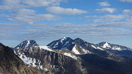
Lake mountain - 8371' / Monument Peak - 8592' / Blackcap mountain - 8397' / Lost Peak - 8464'
June 2018

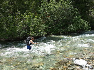
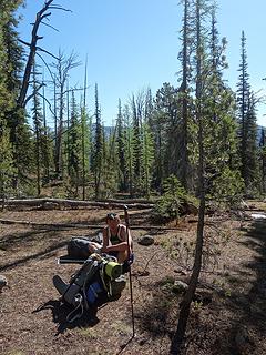
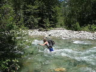
Another excellent Bulger trip with Josh, on Saturday the 16th I left Renton in the morning to pick up Josh in Lynnwood and we were off to the Monument Trailhead near Mazama. With showers ans thunderstorms in the forecast, we decided it was the perfect day for approaching since it wouldn't be as hot. We left my van at about noon and quickly made the 1ish hour hike up the Monument trail to Eureka Creek. Josh had just hiked to this point a few days prior to scout out the crossing and we decided to give this trip a try when he said the water level would not be above my waist. Utilizing my knowledge and experience from crossing many large rivers in Alaska, I briefed Josh on the proper way to ford fast rivers, and we both made it across relatively easily with our sandals. The water level never got to my waist, however since Josh is a bit shorter it did reach his just barely. 

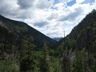
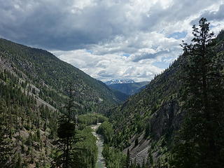
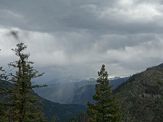
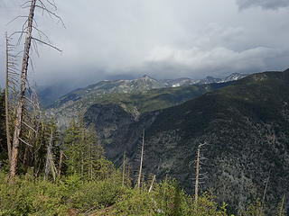
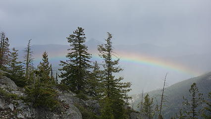
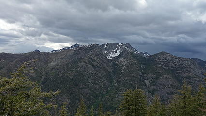
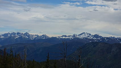
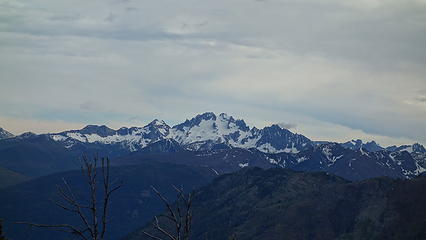
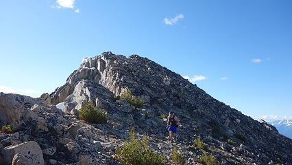
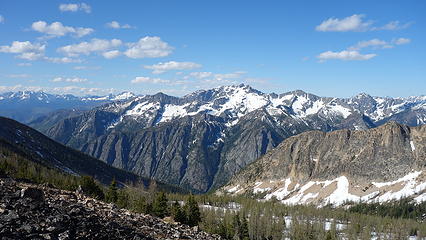
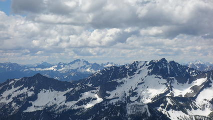
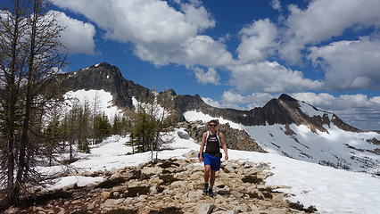
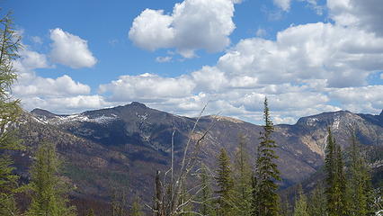
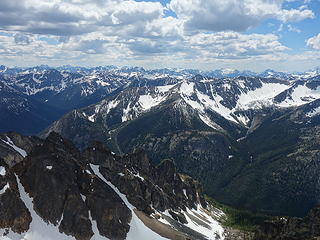
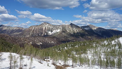
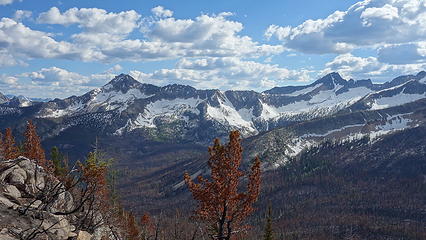
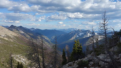
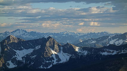
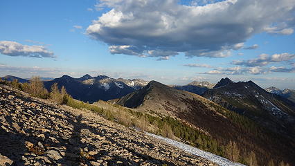
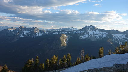
We then located the trail as it began switchbacking up an open talus slope at the base of the long ridge separating the Eureka and Lost River valleys. The trail was mostly easy to follow, however there was quite a bit of downfall, and in a couple places we lost the trail albeit briefly. We made upward progress, and at about 4500 feet we took a small break on a rocky outcrop with a clear view towards Silver Star and the Gardners. We watched a storm slowly approach us as rain fell over the Gardners. We continued, and 20 minutes later it started to lightly rain, with some distant thunder. We waited it out for 15 minutes or so under a tree and continued when the rain eased up a bit. As we neared 6000 feet in elevation, a beautiful rainbow lit up the sky to the east, as a second shower approached us. I thought it was strange the storms were coming from the east, but I know it can sometimes happen. 

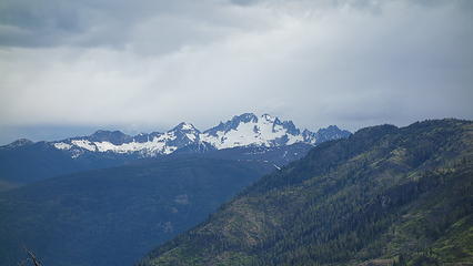
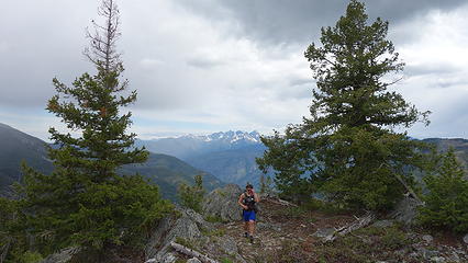
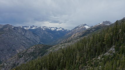
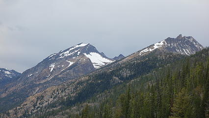
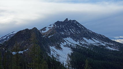
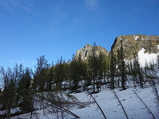
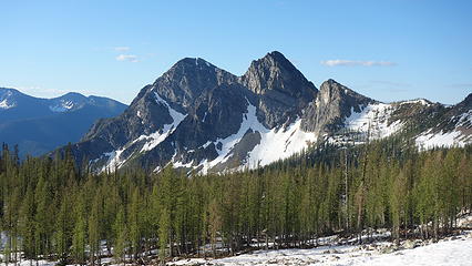
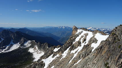
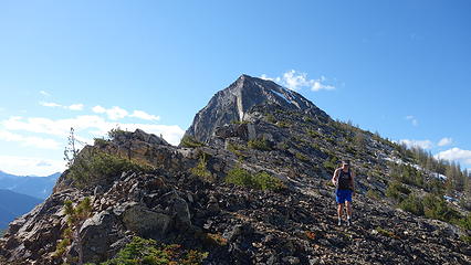
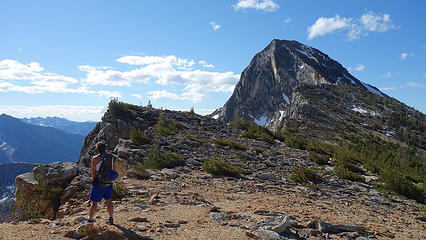
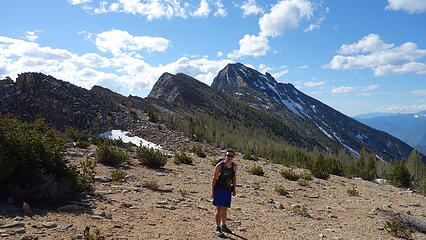
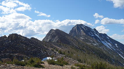
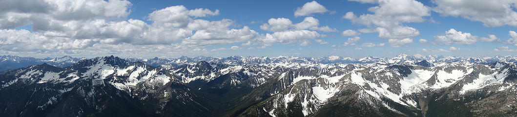
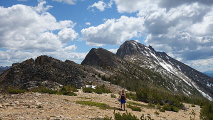
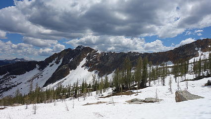
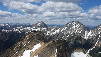
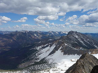
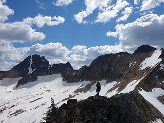
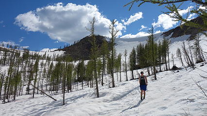
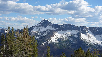
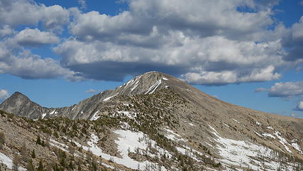
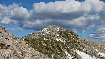
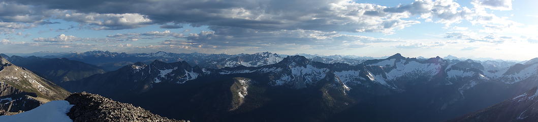
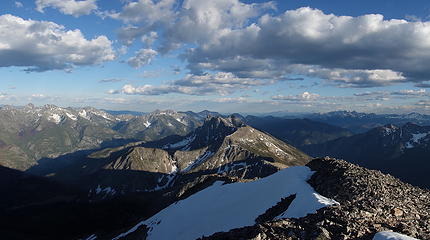
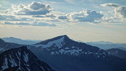
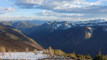
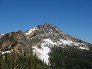
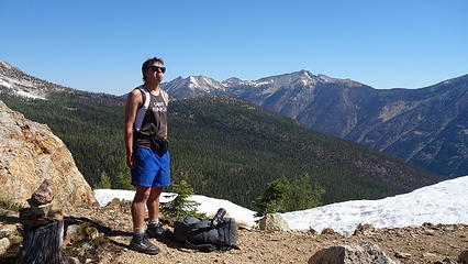
At about 6200 feet elevation along the ridge, we waited out the second shower while we had some smacks and water. The views of Robinson Mountain across the Eureka Valley were superb, and we now could finally see Lake and Monument through the clouds to the north. They were still a long ways away! It was about 5pm by this point, and a few minutes later, we hit 6600 feet where the trail leaves the ridge and begins traversing the SW face of Pistol Peaks. We made quick time to Pistol Pass as the trail was mostly flat, and amazingly in good condition. From Pistol Pass, we got our first views of Lost Peak, waaaayyy over there. Also Lake Mountain, and its small rock spire were staring right at us from here. The wind really picked up here, so we didn't stay long, and quickly descended 600 feet down very soft snow (the first snow we ran into) until we found a nice place to set up the bivy tent roughly 100 feet below, and south of Lake of the Woods. There is a great flat area closer to the trail here at 6500 feet which offers many great camp spots, with less bugs since it's further away from the "lake". We relaxed for the final couple hours of daylight and went to sleep with an early alarm set. We knew we were in for at least a 16 hour day coming up. 

Josh making his way across Eureka Creek
 
 
Our first little storm
 
Silver Star
Silver Star
Lovely rainbow
Lovely rainbow


Lake in the distance
Silver Star and Gardners
 
 
Lake and Monument
Lake and Monument
Lake from Pistol Pass
 
Descending snow from Pistol Pass


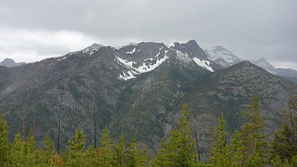
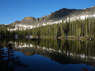
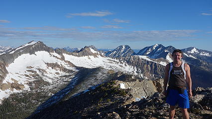
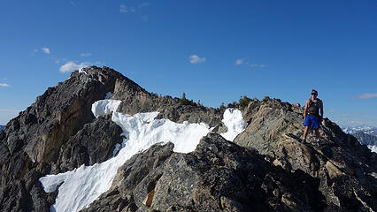
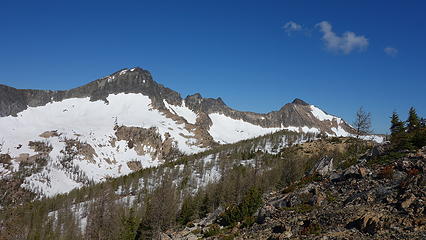
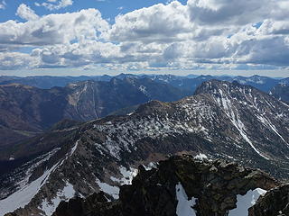
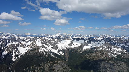
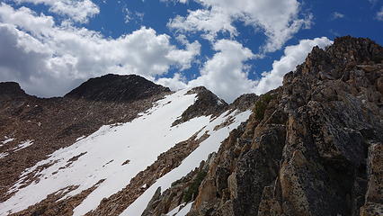
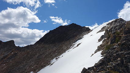
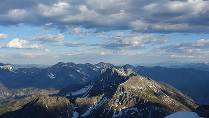
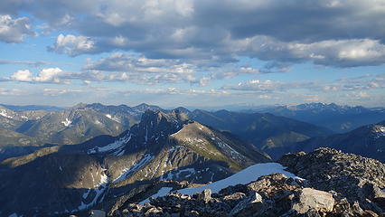
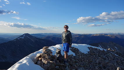
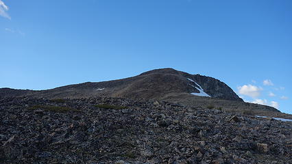
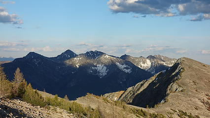
The next morning, we got started a little after 6am. This would be the day we would loop up all 4 Bulgers in an estimated 10,000 feet elevation gain day. We started with just one pack between us that we'd switch off carrying, up Lake Mountain and passing Lake of the Woods along the way (excellent morning reflection). We took the normal route up the obvious east gully (thanks Fred) where the difficulty never exceeded Class 2+. We worked our way up the loose gully, only touching snow for a few small patches. At 7:45 we reached the summit of our first peak and enjoyed the excellent morning lighting on the North Cascades. We scouted out the upper east ridge of Monument, which goes at class 4. Doing this route allows you to traverse directly from Lake to Monument, never having to drop off the ridgecrest saving both time and effort. 

Morning reflection on Lake of the Woods
Looking up the east face of Lake
Pistol Peaks
Pistol Peaks
 
 
Upper east face of Lake


Monument at left
Monument at left
 
 
The crag near summit of Lake


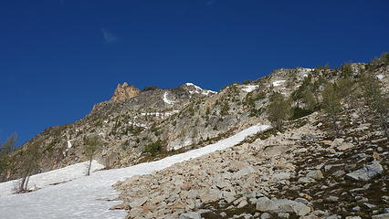
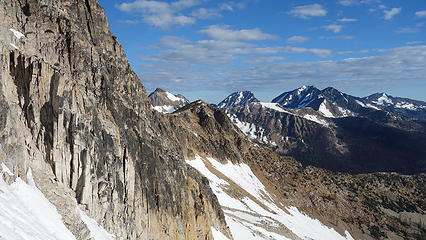
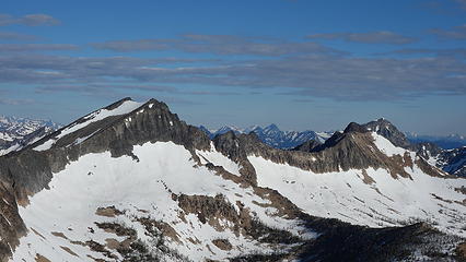
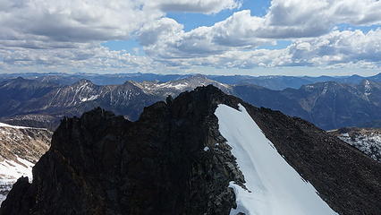
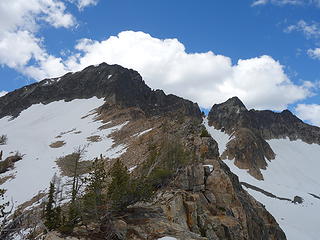
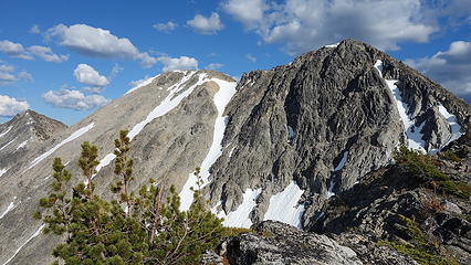
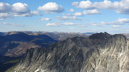
After a 20 minute summit stay, we descended directly down the north ridge of Lake, dropping down a few class 3 steps until the ridge flattened out. We made quick work traversing directly on the ridge to the small 7660 foot saddle just east of a small unnamed point on the lower east ridge of Monument. We left the pack here, as this is where we would return to to drop into the headwaters basin of Lost River. The whole east ridge of Monument drops near vertically into this basin with the exception of this gully which drops at a reasonable 35-45 degree angle allowing us to connect Blackcap and Lost. 

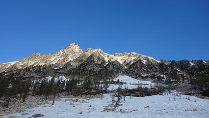
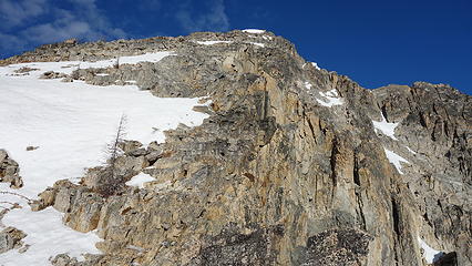
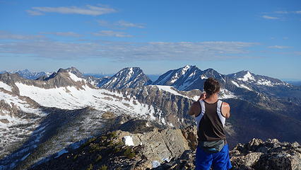
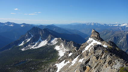
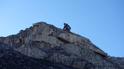
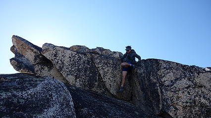
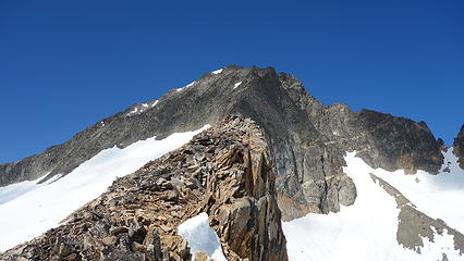
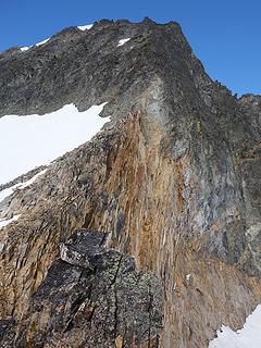
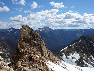
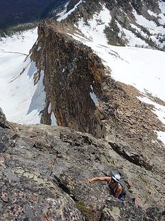
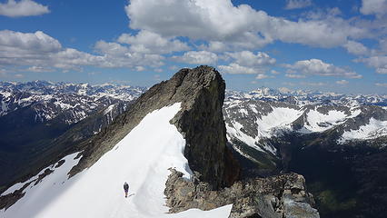
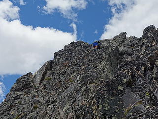
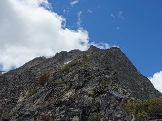
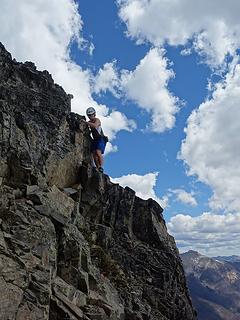
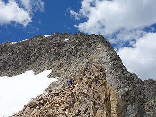
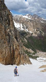
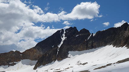
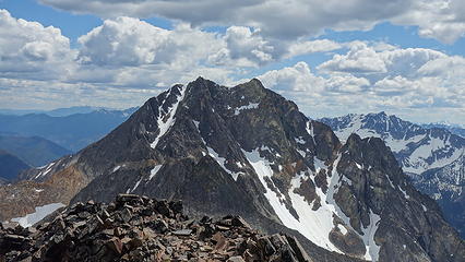
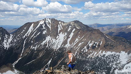
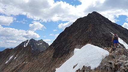
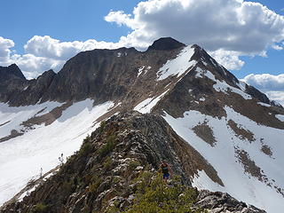
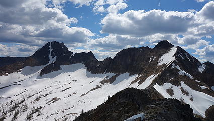
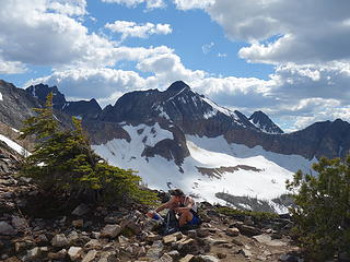
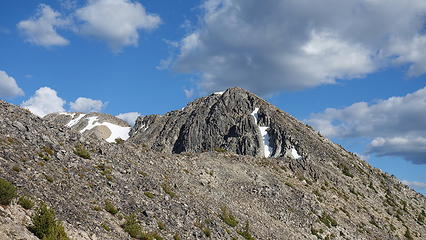
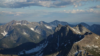
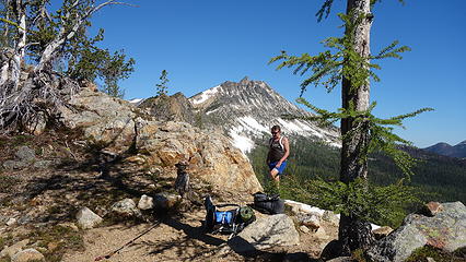
Continuing on to Monument, we reached the base of the upper east ridge, where more difficult scrambling began. The crux was the first 50 feet, where the ridge is steepest. We climbed somewhat blocky and questionable class 4 rock, and at times I had to throw junk off and make my own handholds. Beyond this though, the rest of the ridge was class 3, except for a small knife edge section at the end of the leftward traverse, which I thought was also class 4 (and exposed!). Near the summit, we had to cut left. I reached the east peak of Monument with Josh shortly behind, and realized the west peak was higher, so I made the 5 minute traverse over there and summitted at around 10:30. Peak number 2 was in the books. I actually really enjoyed that scramble, and it certainly beats dropping down the loose west face of Lake all the way to 6600 feet to access the long south ridge of Monument. Monument is the highest in this group so we spent a little more time enjoying the views. 

Beginning the descent down Lake
One of the class 3 steps
Easier for me with my height...
Good view of the upper north ridge of Lake
Approaching the upper east ridge of Monument
 
Josh climbing the crux


The east summit
The east summit
Blackcap in front, Osceola, Carru and Lago behind


Josh traversing back from true summit of Monument


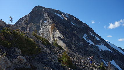
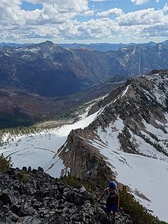
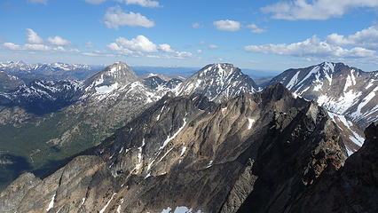
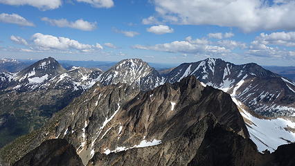
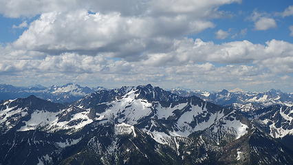
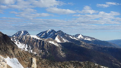
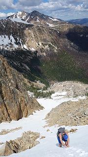
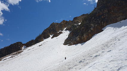
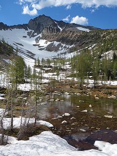
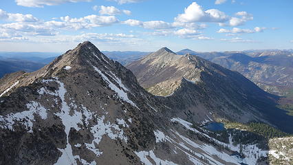
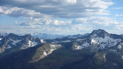
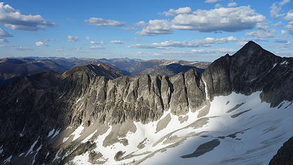
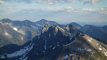
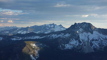
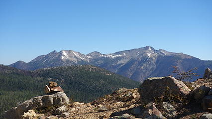
We retraced our steps back down the east ridge and all the way back to our pack. We took a slight variation on the lower crux, traversing skiers right to hit the snow moat and downclimbing along the moat, rather than downclimbing the middle of the ridge. After a short break, we began descending the snow gully into the basin to the north. It was initially 45 degrees but the snow was very soft, so kicking steps wasn't really an issue. Past 100 feet down we were able to plunge step the whole way, and curve left at 6,800 feet around a buttress and into the upper basin. We found a water source to fill our bottles, then continue in a straight line northwest up to 7800 feet on the east ridge of Blackcap. Traversing across this basin was all on snow, with the final 250 feet steepening up to the ridge. We left the pack once again here, and finished the final 650 feet to Blackcap, and our third peak on the day which we topped out at 3pm. This ridge I didn't even think was Class 3 but a couple spots could have been. Both Josh and I were feeling good at this point, however we both knew these were the easy ones. Traversing over to lost was going to be a "piece of work" as Josh put it. 

Josh downclimbing the upper crux
 
Josh making a crossover to get to the moat
Monument Peak
Monument Peak


Easy ridge walking
Easy ridge walking
 
Josh descending the snow gully
Plunge stepping down
 
 
Traversing the basin
NE face of Monument
NE face of Monument
At 7800 feet on Blackcap E ridge
 
 
Carru and Lago from Blackcap
A rock glacier in the basin below
 
 
Lost Peak looking....lost


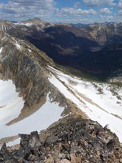
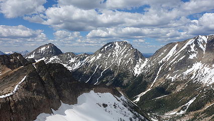
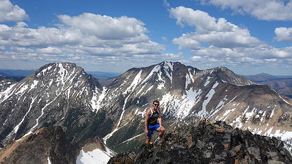
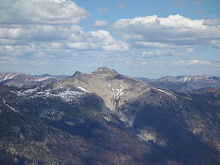
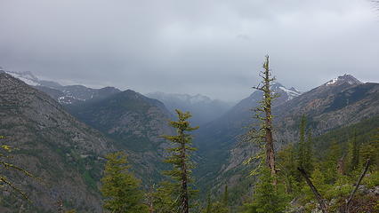
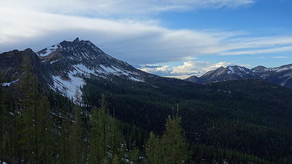
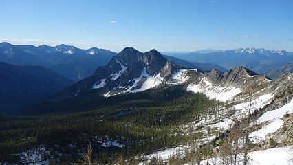
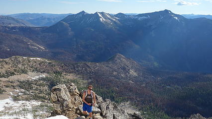
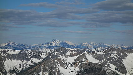
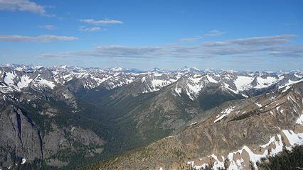
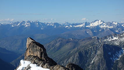
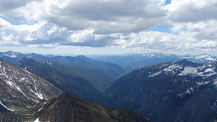
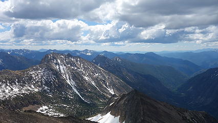
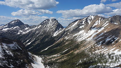
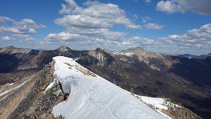
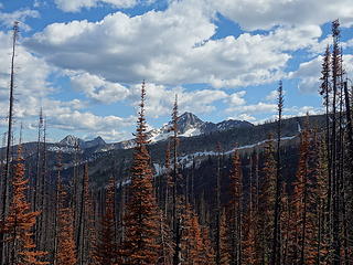
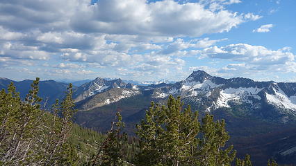
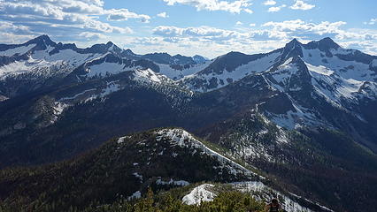
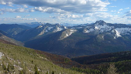
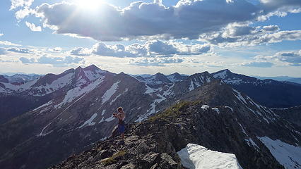
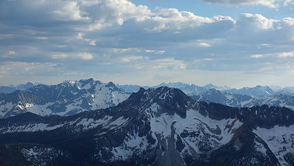
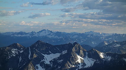
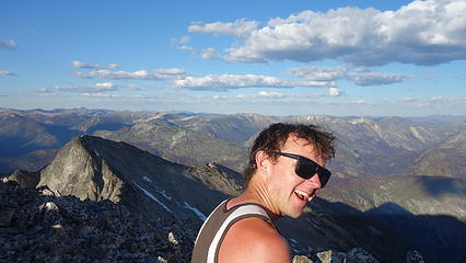
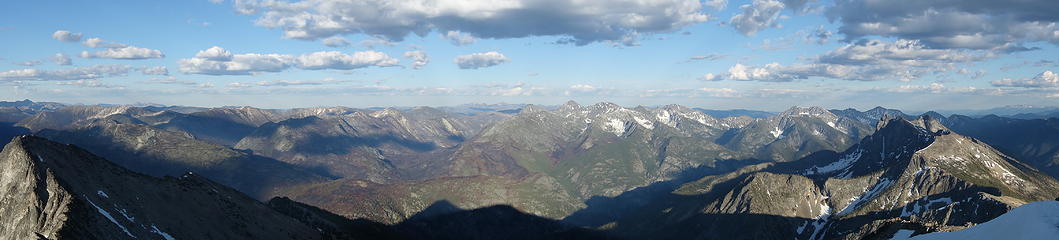
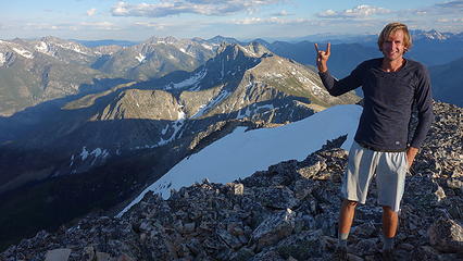
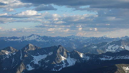
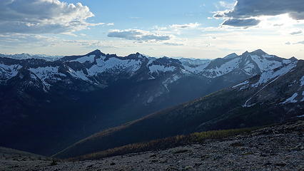
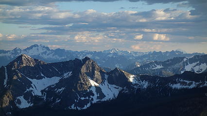
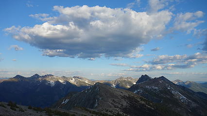
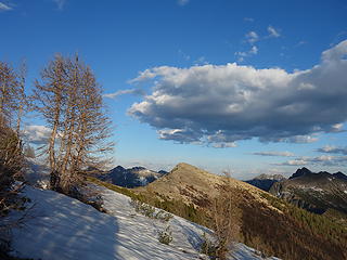
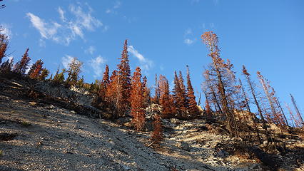
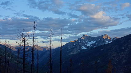
We descended back to the pack, and didn't waste time beginning the long traverse to Lost at 3:30pm. I guessed it would take us 3 hours, leaving us 3 hours of remaining daylight to hike all the way back to camp. In reality, it took 4, even moving fast. The traverse down to Shellrock Pass was a beautiful ridgerun with spectacular views of Carru and Lago. From there, we descended soft snow once again to a small tarn at 6840 feet, where I found the trail. We followed the trail, as the snow disappeared, and we entered a burn area. We reached where the trail junction for Butte Pass would be but found no resemblance of the Butte Pass trail initially due to the burn, so we simply began hiking up. Only 300 feet up brought us to the pass, where we then found the trail as it continued east along the ridge. We began steeper ascending up to point 7260, then dropped a couple hundred feet before ascending once again to Pass Butte. I was really beginning to feel it on this part of the hike. Josh and I made it to the top of Pass Butte at about 6:10pm, and Lost Peak still looked far away! It was another 400 foot descent to the next saddle, followed by a traverse on the south side of point 8100 to the next saddle and then along the long but very easy ridge to Lost Peak, which we reached at 7:30. Our 4th peaks was finally in the books! As the sun was now getting lower in the western sky, we were granted with some spectacular lighting. Cathedral Peak was visible way off to the east, as was all the usual peaks to the west. 

Beginning the descent off Blackcap
 
Traversing to Shellrock Pass
Monument and Blackcap
Osceola, Carru and Lago
 
 
Small arch in a cornice
Resting at Shellrock Pass
 
Descending snow below Shellrock Pass
Small tarn
Small tarn
Entering the burn area
 
Lake Mountain...we were way over there!
 
 
Ascending Pass Butte
 
 
Lost Peak from Pass Butte
 
 
Is it getting any closer?
 
View north from traverse to Lost. Some impressive cliffs over there


Josh on summit of Lost
 
 
Lost summit pano
Lost summit pano
 
 
Happy to be done with all 4 peaks
Ptarmigan Peak...how do people combine Ptarmigan and Lost?


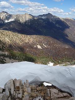
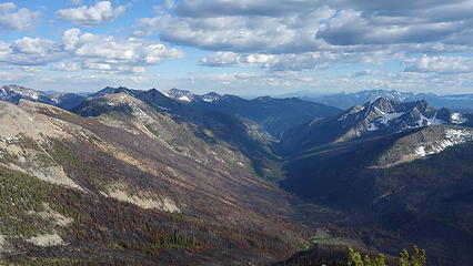
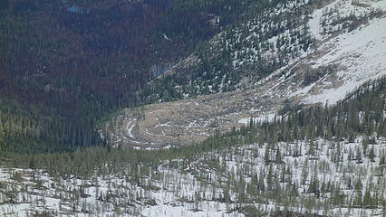
By 7:50 we started descending down the southwest face of Lost all the way to the Lost River 3200 feet down, enjoying amazing photography on the way. We stayed on a ridge between two large ravines which would dump us out right at the trail. The entire valley was burned so we couldn't easily find the trail, however we did manage to spot it, and follow it to where it crosses Lost River. Unfortunately it was getting dark at this point, and I didn't want to fumble around too much. So while we still had some twilight, we forded it. Luckily it wasn't as bad as Eureka Creek since we both left our sandals at camp. We then continued down the trail, losing it often as it was largely destroyed by the fire (I couldn't help but think back to last years' GPW trip Josh and I did where every trail was gone). It got dark and our progress really slowed as we had to hop over dozens of logs and whatnot until the trail began curving right into the valley towards Pistol Pass. It was a difficult, slow, painful re-ascend of 1700 feet back to our camp which we reached just after midnight, after a 15 minute struggle to find it. We immediately went to sleep after a quick dinner with sore legs. 

Beginning the descent off Lost


Josh crossing Lost River


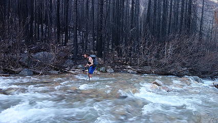
We didn't get out of the sleeping bags until 8am when the sun started directly hitting the tent. We slowly packed up and had to once again re-ascend 600 more feet to Pistol Pass, admire the lostness of Lost Peak once again, then hike all the way back to Eureka Creek. As we dropped elevation, the temperatures increased into the upper 80s and maybe even 90 degrees. HOT. Josh even got a little heat exhaustion on the final 400 feet down to Eureka Creek, since there isn't much water on that ridge. Crossing Eureka Creek was a little higher this time around due to two days of hotter temps melting more snow. Nevertheless, we made it across and finished a miserably hot 3.5 miles back to the van. 

Packing up camp
Packing up camp
 
Admiring Lost Peak
Admiring Lost Peak
Lake from Pistol Pass
 
Josh crossing Eureka Creek again


I do not know what the total mileage for the 3 days was...perhaps 35? I added up the 4 peak loop which was 17 miles, and about 10,000 feet, almost as much as Josh and I's day doing Osceola, Carru, Lago, and Ptarmigan back in September 2016 which was 10,500 feet. For some reason, this day felt harder...maybe because I'm almost 2 years older? haha 

As long as this trip was, I don't think it stacks up to our friends' car to car in one day trip of Olympus they did the 16th (our approach day). Well done Fletcher, Jake and Eric! 

Now that I finished writing this I can go to sleep.  redface.gif

Proudly powered by Weebly