LEMKE CLIMBS
  • About
    • Whats New
    • 2019 Goals/Wishlist
    • Contact
  • Washington
    • North Cascades >
      • Sahale Peak, Boston Peak
      • Eldorado Peak, Klawatti Peak
      • Black Peak
      • Forbidden Peak West Ridge
      • Primus Peak Attempt
      • Big Snagtooth
      • Liberty Bell Beckey Route
      • Burgundy Spire North Face 5.8
      • Ragged Ridge - Katsuk, Kimtah and Cosho Peaks
      • Colfax Peak
      • South Early Winters Spire via SW Buttress
      • Chilliwack Mini-Slam
      • Mesahchie Peak
      • Inspiration Traverse
      • Mount Shuksan Ski
      • Full Pickets Traverse
      • Mount Goode NE Buttress & Storm King
      • Mount Baker North Ridge WI3
      • Snowfield Peak
      • Lincoln Peak
      • Silver Star Mountain
      • Mount Buckner & Horseshoe Peak
      • Azurite Peak
      • Tower Mountain & Golden Horn
      • Mount Logan
      • Custer Ridge & Easy Mox
      • Mazama Dome
      • Sherman Peak
      • Mount Ballard
      • Southern Pickets Traverse
      • Corteo Peak
      • Whatcom Peak
    • Glacier Peak Wilderness >
      • Buck Creek Pass, Cloudy Peak, Spider Gap
      • Dome Peak, Spire Point
      • Mt. Maude and Seven Fingered Jack
      • Mount Formidable NE Face 5.6 Second Ascent
      • Dumbell and Greenwood Mountains
      • Glacier Peak Wilderness Mountain Massacre
      • Clark and Luahna Peaks
      • Sinister Peak
      • Chiwawa Mountain
      • Tupshin & Devore Peaks
      • Buck & Fortress Mountains
      • Glacier Peak
      • Snowking Mountain
    • Olympic Peninsula >
      • Buckhorn Mountain
      • Flapjack Lakes Hike
      • Grey Wolf Peak, High Divide Trail
      • Mount Ellinor
      • Mount Constance West Arete
      • Mount Olympus
    • Alpine Lakes Wilderness >
      • Chikamin Peak
      • PCT - Snoqualmie to Pete Lake
      • Foss Lakes Hike
      • Necklace and Tank Lakes
      • Enchantments Day Hike
      • Granite Mountain (Snoqualmie)
      • Colchuck Peak
      • Cannon, Enchantment and Stuart
      • Ingalls Peaks
      • McClellan Peak
      • Dragontail Peak
      • Web Mountain
      • Mount Index Attempt
      • Snow Creek Wall Orbit 5.8+
      • The Tooth South Face
      • Eightmile Mountain
      • Argonaut Peak NE Couloir
      • Little Annapurna South Face 5.5
      • Snow Creek Wall Outer Space 5.9
      • Cashmere Mountain
      • Sherpa Peak North Ridge 5.8
      • Chair Peak NE Ridge
      • Lichtenburg Mountain
      • Mount Index
      • McClellan Butte
      • Chimney Rock
      • Alpine Lakes High Route
    • Pasayten Wilderness >
      • The Craggies
      • Tiffany Mountain
      • Pasayten Mini-Slam
      • Remmel Group
      • Jack Mountain
      • Robinson Mountain
      • Monument Peak Group
    • Mountain Loop Highway >
      • Vesper Peak
      • Mount Dickerman
      • Sloan Peak West Face 5.8
      • Mount Forgotten
      • Whitehorse Mountain
      • Gothic Peak
    • Lake Chelan Sawtooth Wilderness >
      • Star, Courtney, and Grey Peaks
      • Hoodoo Peak and Raven Ridge
      • Abernathy Peak
      • Mount Bigelow
      • Reynolds Peak
      • Oval Peak
      • Gardner Peaks
      • Chelan Sawtooth Trio
    • Southern WA >
      • Mount Adams
      • Mount Rainier - Emmons Route
      • Mount Saint Helens
      • Goat Peak
      • Lane Peak, Plummer Peak (Tatoosh)
      • The Unicorn (Tatoosh)
      • Little Tahoma
      • Liberty Cap
    • WA Rock and Ice Cragging >
      • Index Town Walls
      • Vantage
      • Mount Erie
      • Exit 38
      • Leavenworth
  • Colorado
    • San Juan Mountains >
      • Mount Sneffels Lavender Snow Climb
      • Uncompahgre, Matterhorn Peaks
      • Redcloud, Sunshine Peaks
      • San Luis Peak
      • Vermilion, Fuller Peaks
      • Stewart Peak, Baldy Alto
      • Jones, Niagara, American Peaks
      • Wetterhorn Peak, Handies Peak
      • Wilson Group
      • Arrow Peak
      • Mount Sneffels SW Ridge
      • Jagged Mountain, Chicago Basin
      • Teakettle Mountain
      • Dallas Peak
      • Vestal Peak Wham Ridge, Greystone Peak
      • Organ Mountain
      • Phoenix Peak
      • Half Peak
      • Point 13832 Group
      • Golden Horn
      • Mount Sneffels Snake Couloir
      • Pigeon, Turret Peaks
    • Elk Mountains >
      • Four Pass Loop
      • Castle, Conundrum Peaks
      • Snowmass Mountain
      • Cathedral Peak
      • South Maroon Peak
      • The Pyramids
      • North Maroon Peak, Sleeping Sexton
      • Capitol Peak, Mount Daly
      • Malemute Peak
      • Hagerman Peak
    • Sangre de Cristo Mountains >
      • Blanca Peak, Ellingwood Point
      • Challenger Point
      • Mount Adams
      • Spread Eagle Peak
      • Humboldt, Obstruction, Columbia Peaks
      • Mount Lindsey, Huerfano Peak
      • Little Bear Peak
      • Crestone Needle Ellingwood Arete
      • California Peak
      • Crestone Peak North Buttress
      • Operation Dark Snake
      • Kit Carson Mountain
    • Sawatch Mountains >
      • Iowa Peak
      • Point 13,618 - Hunky Dory Lake
      • Gold Dust Peak, Notch Mountain
      • Mount Jackson
      • Mount Belford
      • Shavano, Tabeguache Peaks
      • Mount Antero, Cronin Peak
      • Twining Peak
      • Mount Massive
      • Casco Peak
      • Mount Huron
      • Mount Elbert
      • Mount Oxford
      • Mount Hope
      • Mount Yale
      • Lackawanna Peak
      • Mount Columbia
      • La Plata Peak
      • Rinker and Twin Peaks
      • Bull Hill, Mount Princeton
      • Missouri Mountain
      • Mount Oklahoma
      • French Mountain
      • Mount Ouray
      • Grizzly A, Garfield Peaks
      • Mount Harvard
      • The Three Apostles
      • Emerald Peak
      • Holy Cross
      • Mount Aetna
    • Greater Park Range >
      • Kneeknocker Pass, Piney Lake
      • Drift Peak
      • Sherman Peak, Dyer Peak
      • Gore Range Traverse
      • Quandary Peak
      • Pacific, Atlantic Peaks
      • Clark Peak
      • Crystal Peak, Peak 10
      • Fletcher Mountain
      • The DeCaLiBron
      • Loveland Mountain
      • The Mosquito Traverse
      • Mount Arkansas
      • Clinton Group
      • Eagles Nest, Peak C
      • North Star Mountain
      • Peak X
      • Wheeler Mountain
    • Front Range >
      • Mount Evans, Spalding
      • Mount Bierstadt
      • Mount Parnassus, Bard Peak
      • Cupid, Sniktau, Grizzly D Peaks
      • James Peak
      • Mount Silverheels
      • Grays and Torreys Peaks
      • Mount Edwards
      • Mount Flora, Longs Peak
      • Square Top Mountain
      • Petit Grepon South Face 5.8
      • Mount Meeker Dreamweaver Couloir
      • Santa Fe Peak
      • The Citadel & Pettingell
    • Colorado Ice Climbing >
      • Lincoln Ice Falls
      • Ouray Ice Park
      • Avocado Gully and The Drool
      • Hidden Falls
    • Colorado Rock Climbing >
      • Eldorado Canyon
      • The Flatirons
      • North Table Mountain
      • Shelf Road
      • Colorado National Monument >
        • Independence Monument
  • Wyoming
    • Wind River Mountains >
      • Gone With the Winds
      • Union Peak - Solar Eclipse
      • Wind River Peak
      • Wind River Slam
    • Teton Range >
      • Grand Teton Owen Spalding 5.4
      • Mount Owen Attempt
    • Wyoming Absarokas and Gros Ventre Range >
      • Jackson Peak
      • Francs Peak
    • Yellowstone National Park >
      • Top Notch Peak
    • Bighorn Range and Great Divide Basin >
      • Boars Tusk
      • Loaf Mountain
      • Cloud Peak
      • Black Tooth Mountain
    • Devils Tower
    • Cody Rock and Ice Climbing
  • Montana
    • Beartooth Mountains >
      • Whitetail Peak Group
      • Beartooth Mountain
      • Spirit Mountain Group
      • Mount Peal
      • Granite Peak Group
      • Castle Rock Group
      • Castle Mountain NE Couloir
      • Mount Inabnit and Sylvan Peak
      • Mount Hague South Slopes
      • Mount Villard and The Granite Peaks Traverse - 5.4
      • Spirit Mountain NE Ridge - 5.4
      • California Ice WI 4
      • The Ramp 5.8
      • Linea Alba 5.10d
      • Iceberg Peak
      • Metcalf Mountain North Rib 5.8
      • Villard Spires HP West Ramp
      • Cairn Mountain
      • Snowbank Mountain
      • Mount Wood Group
      • Bears Tooth
      • Glacier Peak Catch-a-Sunrise FA
    • Montana Absarokas & Gallatin Range >
      • Black Mountain
    • Southwest Montana Ranges >
      • Sacajawea Peak
      • Arrow Peak
      • Koch Peak
      • Saddle Peak
      • Baldy Mountain
      • Sphinx Mountain
    • Glacier National Park >
      • A Taste of Glacier National Park
      • Divide Mountain
    • MT Rock and Ice Climbing
  • Utah
    • Uinta Mountains >
      • Kings-Emmons Ridge Run
      • Hayden Peak
      • Iron Hayden Wall Rock Climbing
    • Wasatch Range >
      • The Sundial Eleventh Hour 5.8
      • Mount Timpanogos
    • San Rafael Swell >
      • Ramp, Cistern Canyons
      • Salt Wash, Black Mountain, Moroni Slopes
      • Ding, Dang Canyons
      • Little Wild Horse, Bell Canyons
      • Quandary Canyon
      • San Rafael Knob
      • Miners Hollow (Knotted Rope Canyon)
      • Temple Mountain
      • Chimney Rock
      • Bottleneck Mesa
      • Window Blind Peak
      • Lower Baptist Draw & Upper Chute Canyon
    • Capitol Reef National Park >
      • Cathedral Valley Tour
      • Sheets Gulch
      • Halls Creek Narrows
      • Brimhall Canyon and Strike Valley Overlook
      • George Benchmark
    • Moab Area, Canyonlands, Arches >
      • Maze District
      • Needles District
      • Maze District
      • White Rim Trail Biking
      • Elephant Butte, Bullwinkle Tower and Lizard Rock
      • South Six Shooter
      • Elephant Canyon
      • Parriott Mesa
      • Ancient Art
      • Castleton Tower North Chimney 5.8
      • Klondike Bluffs
      • Mount Peale & Tukuhnikivatz
    • Robbers Roost Country >
      • Horseshoe Canyon, Goblin Valley
      • Bluejohn Canyon
      • Happy Canyon Narrows
      • Shenanigans, Leprechaun Slots
      • Larry Canyon
      • Merry Piglet Slot
      • Lower Maidenwater Canyon, Turkey Knob
      • Morocco Canyon
      • Monkey Business Slot
      • Hog Canyon Slots
      • Upper Maidenwater Canyon Slots
      • Mount Ellen
      • Buck Canyon
      • Point 4906
      • Alcatraz Canyon
      • Hard Day Harvey Slot
      • Mount Ellsworth
      • Good Day Jim Canyon
      • White Roost Canyon
      • Upper Stair Canyon
      • Dragon Canyon
    • Escalante National Monument >
      • Phipps Canyon and Arch
      • Red Breaks Slot
      • Dry Fork Slots, Coyote Gulch
      • Little Death Hollow/Wolverine Canyons
      • Egypt 3 Slot
      • Egypt 1 Canyon
    • Zion/Bryce >
      • Ataxia Tower Ashtar Command 5.9
      • Mount Kinesava Cowboy Ridge
      • Birch Hollow
      • Aires Butte
      • West Temple
      • Mystery Canyon
      • Crazy Streak
    • Cedar Mesa Region/Valley of the Gods >
      • Eagle Plume Tower Eagle Feather 5.10b
  • California
    • High Sierras, Southern CA Ranges >
      • Telescope Peak, Manly Beacon
      • Tahquitz Rock Whodunit 5.9
      • Tahquitz Rock Long Route 5.9
      • Palisade Traverse
      • White Mountain
    • Yosemite National Park, Central CA
    • Northern CA Cascades >
      • Lava Beds National Monument
      • Mount Shasta
  • Oregon
    • Oregon Volcanoes >
      • Three Fingered Jack
      • Mount Scott
    • Blue Mountains >
      • Twin Peaks
    • Trout Creek Rock Climbing
  • Alaska
    • Eagle Peak and Mount Ewe
    • Jatt Peak and Portage Pass
    • Rainbow Peak
    • Mount Brooks Attempt
    • Arrigetch Peaks Trek
    • Ab Mountain Hike
    • South Suicide Peak
    • Mount Hunter West Ridge Attempt
    • Cantata Peak Attempt
    • East Twin Peak
    • Mount Alice
    • Crow Pass and Hope Point Hikes
    • Indianhouse Mountain Attempt
    • Lynx Peak
    • Harding Icefield Hike
    • Hatcher Pass and Grapefruit Rocks Climbing
    • Mount Sanford
    • Mount Hunter West Ridge
  • Nevada
    • Ginger Cracks 5.8
    • Mescalito Dark Shadows 5.8
    • Birdland and Olive Oil
    • Frogland 5.8
    • Johnny Vegas 5.8
    • Schaeffer's Delight & Triassic Sands
    • Solar Slab - 5.6
  • British Columbia
    • Mount Matier
    • Taiya Peak
    • Bugaboo Spire NE Ridge
    • Mount Sabine Easy Honey 5.10b
    • Mount Sir Donald NW Ridge Attempt
    • Black Tusk
    • Squamish Ticks
    • Slesse Mountain NE Buttress
    • Warden Peak
    • Triple Peak
  • Alberta
    • Mist Ridge Hike
    • Mount Temple Attempt
    • East Wendell Peak
    • Loder Peak
    • Tower Mountain Attempt
    • The Rimwall
    • Mount Yamnuska Directissima 5.9
    • Mount Lawrence Grassi
    • Mount Lorette
    • Roche A Perdrix
    • Mount Edith Cavell East Ridge 5.3
    • Mount Louis Kain Route
    • Eiffel Peak
    • Canadian Rockies Ice Climbing
  • Other States
    • Arizona >
      • Grand Canyon Bright Angel Trail
      • Beanfest at Cochise Stronghold
      • Baboquivari Peak
      • Humphreys Peak
    • New Mexico >
      • Philmont Trek August 2008
    • Yukon >
      • Canyon Peak
  • International
    • Mexico & Central America >
      • Mexico - Pico de Orizaba, Izta
      • Guatemala Volcanoes
    • South America >
      • An Introduction to Patagonia
      • Cordillera Blanca - Tocllaraju and Urus
      • Nahuel Huapi National Park & The Frey
      • Exploring Pucon and Lanin Volcano
      • Cordillera Blanca - Ishinca Peak and Artesonraju
      • Cordillera Blanca - Quitaraju & Alpamayo
      • Exploring Southern Peru
      • Cerro Helio Azul & Tronador Attempt
      • Aguja Guillaumet Amy Couloir
      • Cerro Puntado & Palo
      • Cerro Colorado
      • Cerro Puno & Agudo
      • Cerro Trinidad Attempt
      • Volcan Quetrupillan
      • Cerro Placas
      • Nevado de Acay
      • Pequeno Alpamayo
      • Huayna Potosi
      • Illimani
      • Chiaro de Luna
      • Cerro Barros Arana
    • Oceania >
      • Exploring New Zealand's South Island
      • Puncak Jaya
      • Mount McPherson and Talbot
      • Single Cone
      • Mount Cook
      • Mount Aspiring
      • Manakau
    • Central Asia >
      • Kyrgyzstan 2021
  • Sorted by Year
    • 2008 Trip Reports
    • 2009 Trip Reports
    • 2010 Trip Reports
    • 2011 Trip Reports
    • 2012 Trip Reports
    • 2013 Trip Reports
    • 2014 Trip Reports
    • 2015 Trip Reports
    • 2016 Trip Reports
    • 2017 Trip Reports
    • 2018 Trip Reports
    • 2019 Trip Reports
    • 2020 Trip Reports
    • 2021 Trip Reports
    • 2022 Trip Reports
  • Vanlife
    • Conversion Journal >
      • Floor Installation
      • Folding Bed
      • Coffee Table
      • Thinsulate Installation
      • The Couch
      • The Wardrobe
      • Bookshelf
      • Water System
      • Electrical System
      • The Pantry
      • Refrigerator
      • Tire Upgrade
      • Heating System
      • Composting Toilet
LEMKE CLIMBS

Cerro Puno & Cerro agudo

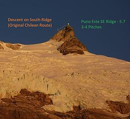
Cerro Puno - 6916' - SE Ridge Class 5.7
​February 2018

As part of our 2018 Patagonia trip, one of the climbing objectives Itai, Elaine and I found are Cerro Puno, which we saw in the newly published 2017 AAJ written by Tad (a friend of mine), and Jim Donini (a local to Durango who has been residing in Patagonia for 4-5 months every year for over a decade, and a legend in the Patagonian climbing scene). We were on the long 22 hour bus from El Bolson to El Chalten in late January wen we stumbled upon Tad's article (see link here), and we all knew we just had to visit the area at some point on our trip.

We were lucky with the weather in Chalten, and we got to climb the Amy Couloir on Guillaumet in perfect, windless weather, however that story is for another day. Fast forward to the middle of February, and the three of us are in Coyhaique after taking the ferry across Lago Gral Carrera from Chili Chico, on a heinously rainy day desperate to rent a car so we can make the drive all the way up the X-890 gravel road along the Rio Baker and Rio Colonia to its end just before Lago Colonia. We however could not find a place in the largest town in Patagonia that had a car available, even after trying 25 different rental car places. With the next good weather window approaching just a couple days away, we were growing more and more desperate for simple transportation back south to Cochrane. The bus schedule didn't align with when we needed to leave, and the one bus that was leaving that day was full. Amazingly we ran into one woman we saw in Villa Cerro Castillio just a week prior, who gave us a ride a ways down the Austral. She knew a few people in town with transportation services so she made some calls for us. Unfortunately no one was willing to help us out for a reasonable price so we were once again back at square one. Feeling defeated, and losing hope on being able to climb Cerro Puno as the good weather was returning, we went back to our hostel and started trying to think of backup plans and slept off a frustrating day.

The next morning, I went to the nearby bus station in hopes of being able to get on some kind of bus going anywhere south, however with the limited schedules, no buses were heading south that day, and the few that were were filled days ago. But by a stroke of luck, an English woman saw my frustration and mentioned to me that the taxi driver she just had moments before (she was just dropped off at the bus depot) had told her he was planning to drive south to Tortel in their van with his family for an asado vacation. She even had his phone number and told me I should contact him because he would have extra space.

I couldn't believe it! So I met back up with Itai and Elaine and found the first Wifi we could find and called him. He agreed to give us a ride down, and would be leaving in just a couple hours! We were thrilled, however still a little skeptical. In his broken English, we were able to decipher he needed to do some shopping at the supermarket first, and we should meet him there, which coincidentally was just a couple blocks from our hostel. So we packed up and checked out and made our way to the Wal-Mart sized market and waited. After an hour or so of waiting, we found him (along with his wife, brother and three kids!), and as friendly as could be they invited us into their van and off we went southward along the Austral. All we had to do at this point was to ensure we made it to Cochrane before 10am so we could rent the bikes we needed to bike up X-890 road.


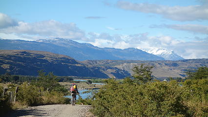
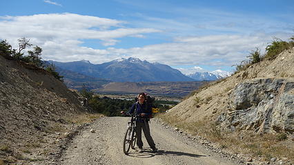
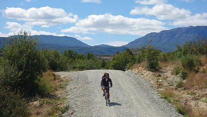
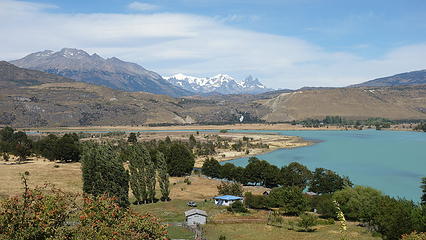
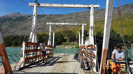
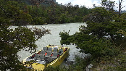
After a long drive that took most of the day, we arrived in Cochrane at 9:55pm and got the bikes we needed just in time. Just next door to the outdoor shop was an open field owned by a nice old lady who allows travelers to camp. We set up the tent here and the owner called a taxi for us to take us to the barge crossing early in the morning. We thought the barge that brings cars across Rio Baker (Balsa Baker) only ran at 7:00 in the morning because a sign we found on google that provided hours of operation for the barge was not clear if it was a continuous run, or only once at the said time. So we didn't risk it and planned to be there before 7 (about 8 kilometers north of town).

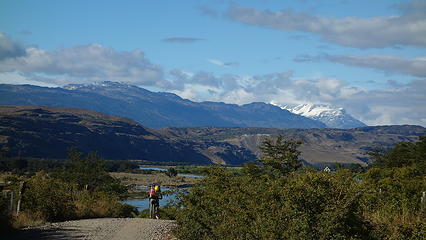
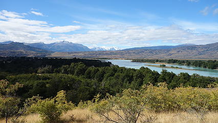
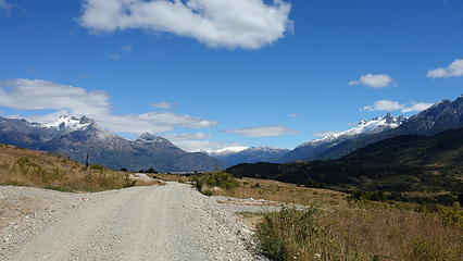
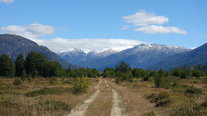
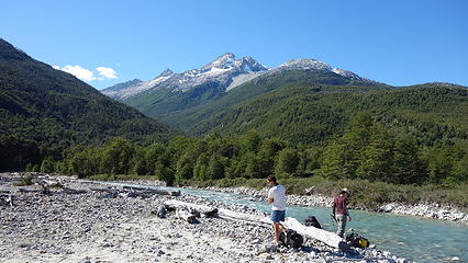
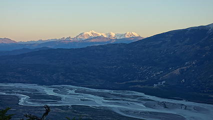
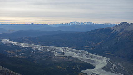
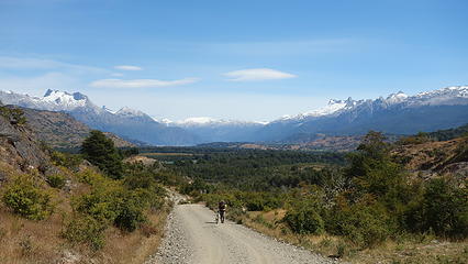
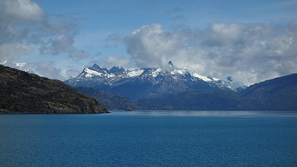
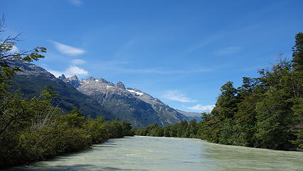
As if the world was still conspiring against us climbing Cerro Puno, the taxi driver of course didn't arrive so we had to bike the Austral up to the barge crossing. When we made it, we found out the barge crosses continuously every time someone arrives during the posted hours. This is basically a large raft tethered to a cable that brings cars, trucks and people across the very wide Rio Baker, and connects to the X-890 road. Once across, the biking really began. Apart from a short ride we were able to hitch from a couple guys in a pickup truck, we biked a large chuck of the 20 kilometers all the way up the valley, along the shore of Rio Baker. About halfway to the roads end, Rio Colonia dumps into Rio Baker and turns sharply south. Just as we reached a large gate, we ran into another person we met in Villa Cerro Castillio. He was taking clients out in his Jeep after a long hiking trip he was guiding. He was so inspired we were biking up the road in order to access the climb we were determined to do. As it turns out, we would run into him many more times on our trip, as he lived in Puerto Guadal.

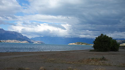
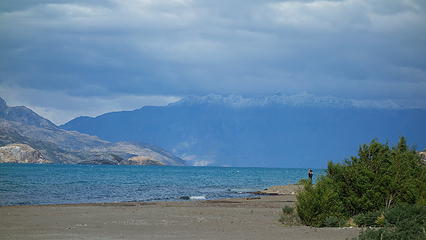
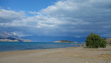
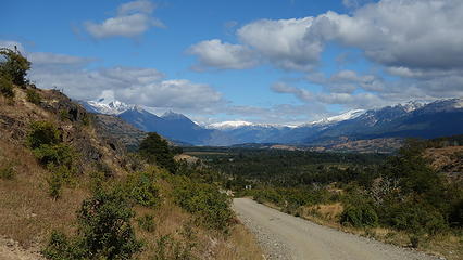
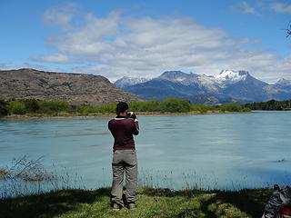
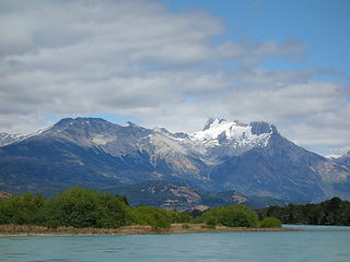
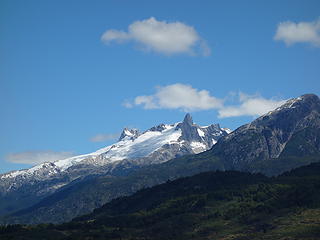
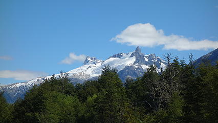
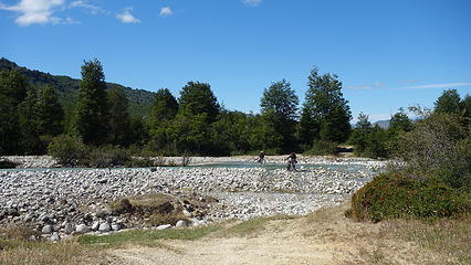
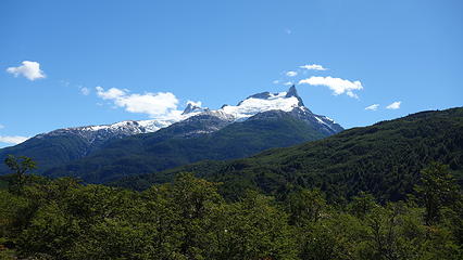
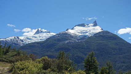
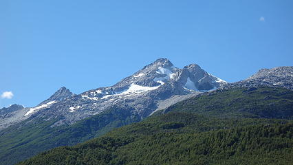
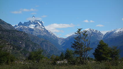
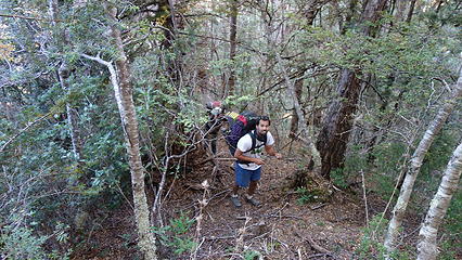
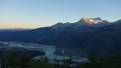
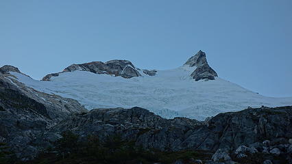
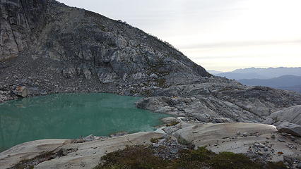
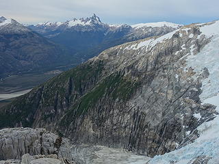
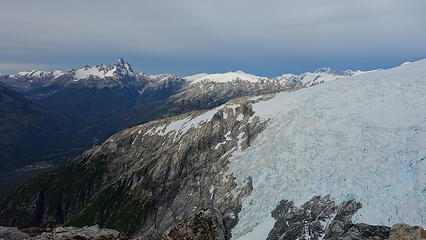
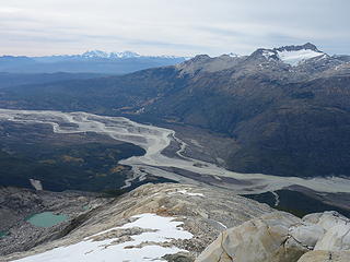
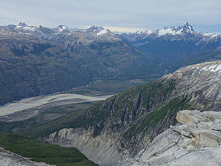
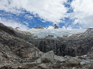
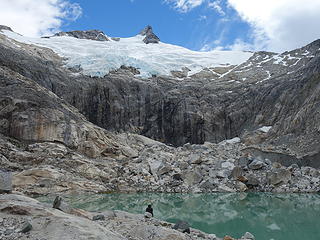
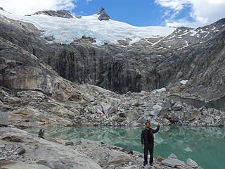
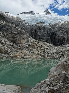
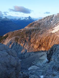
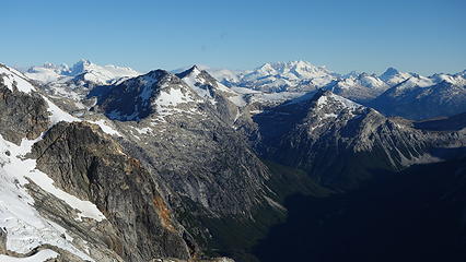
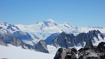
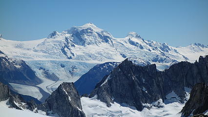
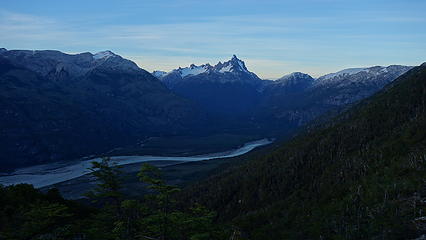
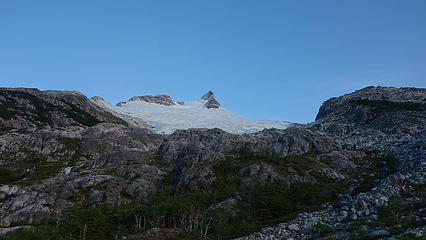
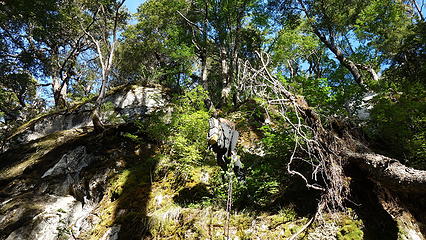
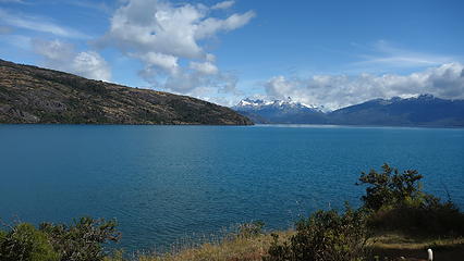
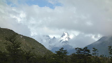
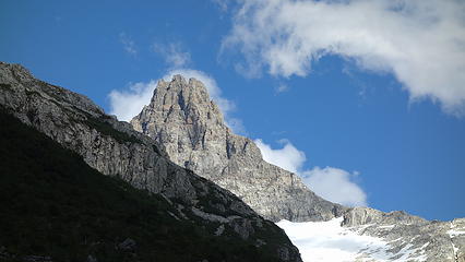
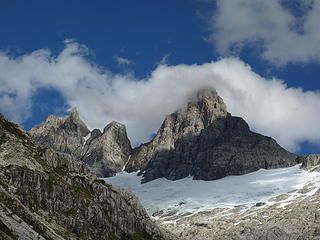
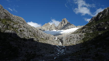
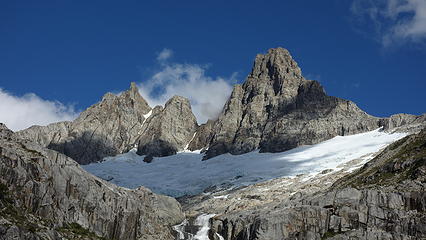
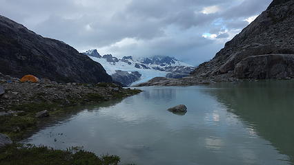
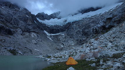
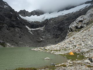
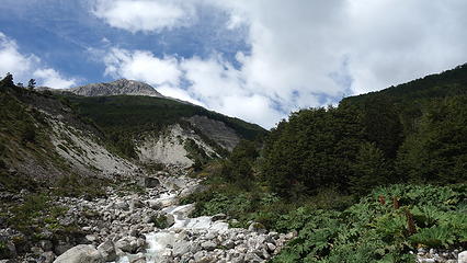
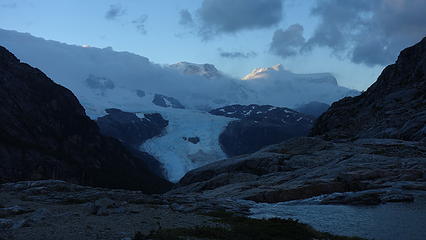
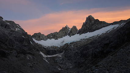
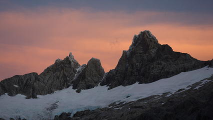
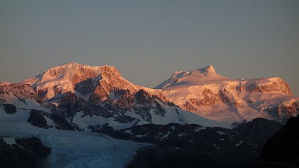
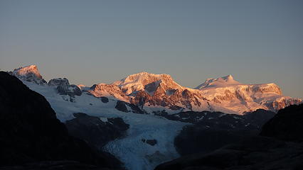
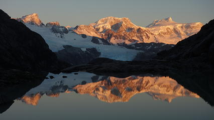
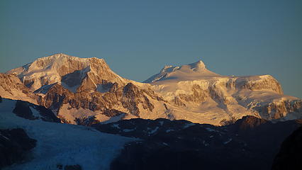
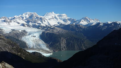
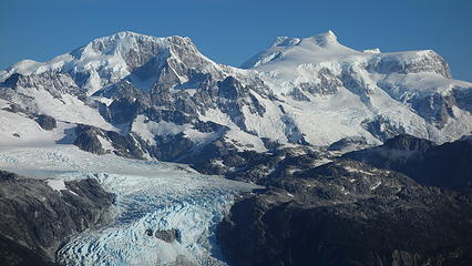
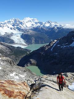
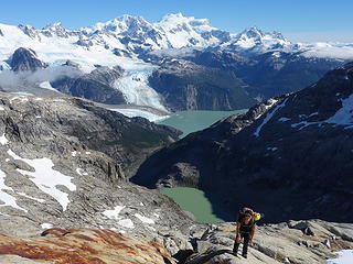
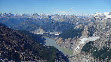
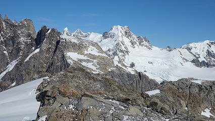
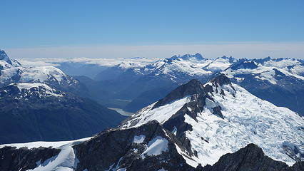
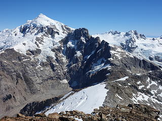
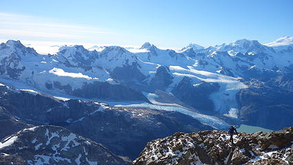
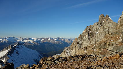
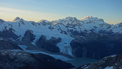
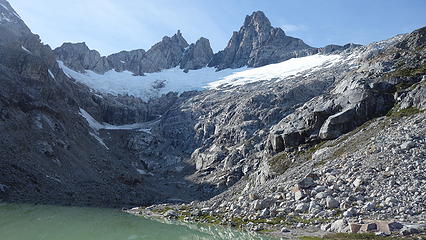
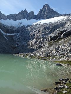
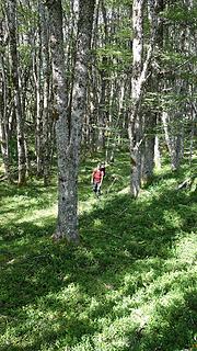
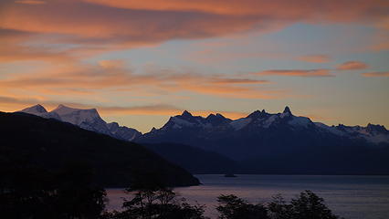
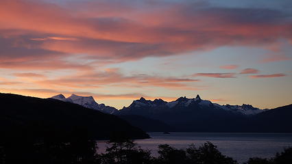
The views continued to get better and better as Cerro Puno loomed closer. Views of Cerro San Lorenzo off to the SE were great, and the striking east face of Puno drew us closer. We were able to convince a local homesteader in the valley to give us a ride up a little further to give us a break from riding with our heavy packs on. He was able to take us to Los Tres Limones, where a drainage stream blocked passage for his truck. We walked the bikes across this fairly rapidly moving river, and continued another 2-3 kilometers to La Rinconada, where the last homestead is located on the north side of Rio Colonia. Here the road completely ends and we left the bikes out of sight of the empty home and forded Estero Aroyo Chueco. Here we knew we had a terrible bushwhack ahead of us, and we studied the slope that lie ahead before we entered the jungle. 750 meters up is what separated us from the valley floor to the infinity tarn that sits secretly in the beautiful basin just below Puno Este. The ensuing bushwhack involved copious amounts of swearing, navigating, and even crying but amidst the bamboo, thorny bushes and steep moss we emerged above the trees just as the sun was setting, and we were greeted with a jaw dropping view across the valley of wild lands unknown. In particular, Cerro Disfiladero off to the south was the best looking peak around, and begs me to return for its potential first ascent.

Rio Baker
Rio Baker
Biking the X-890
Biking the X-890
 
Cerro Puno in the distance
Reflections in Rio Baker
 
 
Cerro Puno getting closer


Road deteriorating
Road deteriorating


First views of Cerro Disfiladero
Crossing one of many streams
Schwacking up
Schwacking up
 
 
San Lorenzo in the distance
Disfiladero...god what a beautiful mountain
Sunset on San Lorenzo
 
Puno Este
Puno Este


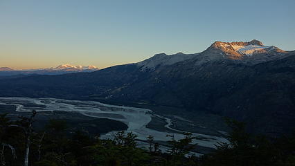
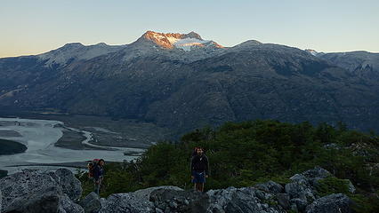
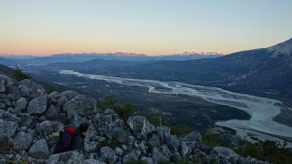
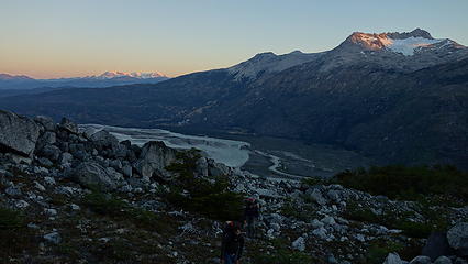
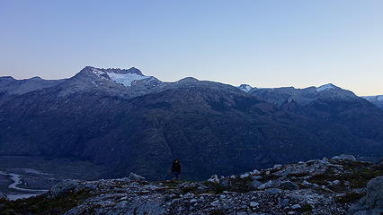
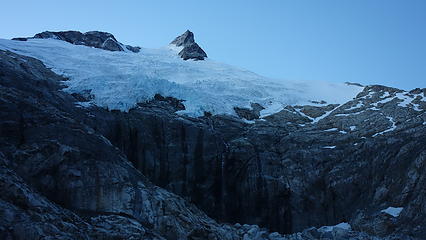
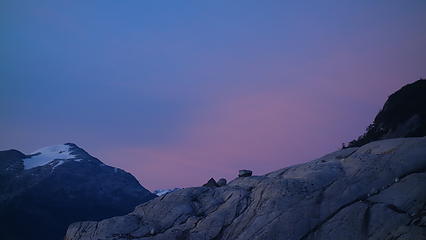
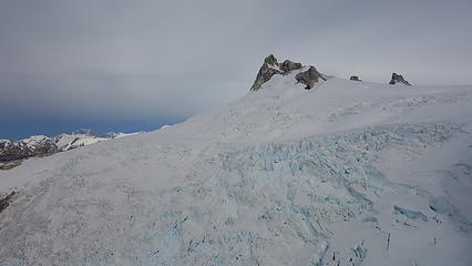
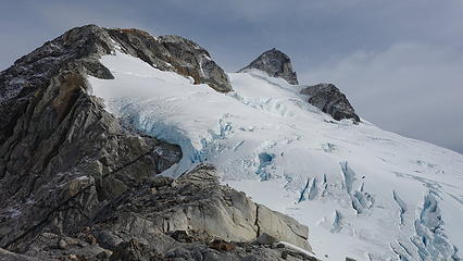
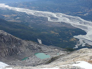
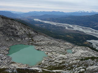
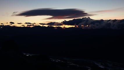
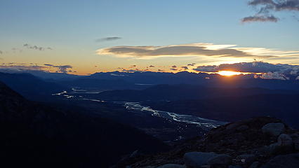
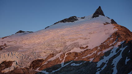
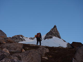
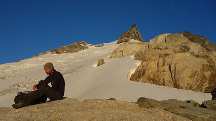
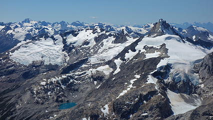
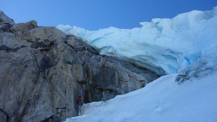
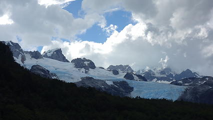
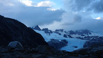
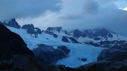
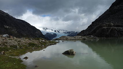
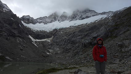
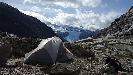
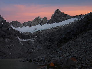
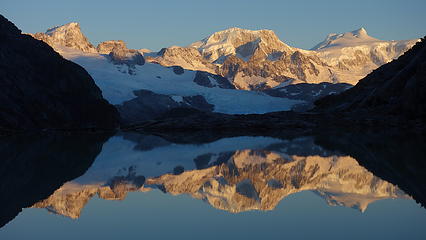
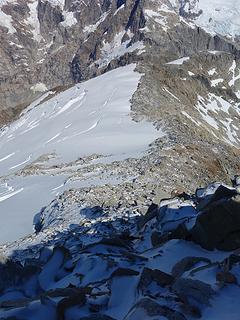
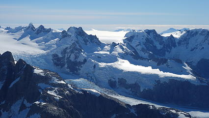
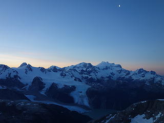
We made camp near the gorgeous tarn and didn't hesitate to go to sleep. We had just biked over 20 kilometers, AND bushwhacked 750 meters up all with heavy packs. Needless to say we were exhausted. The next morning Itai and Elaine wanted a rest day, and since the weather wasn't too great (some clouds), we agreed to wait a day. I went ahead and did a little scouting mission up the ridge left of the tarn to scout our likely descent route. I scrambled up slabs and gullies onto the ridge that separated the basin we camped in from the wildly rugged glacial basin just to the west. The calm, ambient tarn we temporarily called home was contrasted with a raging glacier  just one small valley over.I continued along the gentle ridge until I was stopped by an icefall and glacier serac overhanging above a steep couloir that led to the rugged glacier below me to the left. I figured we would either have to descend on the glacier or rappel straight down this obstacle on our descent. As the clouds off to the west appeared to get darker, I retreated back to camp where I rested the afternoon together with Elaine and Itai and prepared for the early morning wake up.

Sunrise on Puno Este from our tent
The tarn we camped by
 
 
Looking towards Disfiladero
Looking down the next valley with rugged glacier
Rio Colonia Valley
Rio Colonia Valley
Cerro Puno Oeste...also possibly unclimbed
 
 
The serac that blocked further passage without ropes
 
Darker clouds to the west
 
Camp down there
Camp down there


Can't get over how beautiful it is


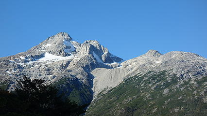
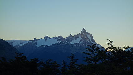
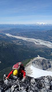
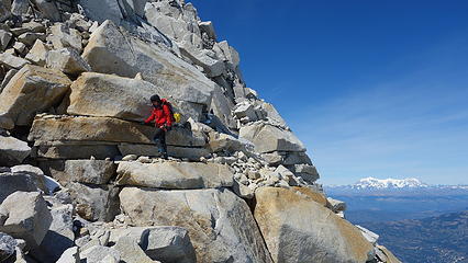
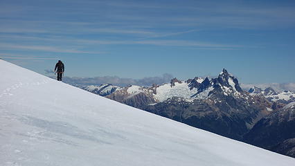
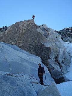
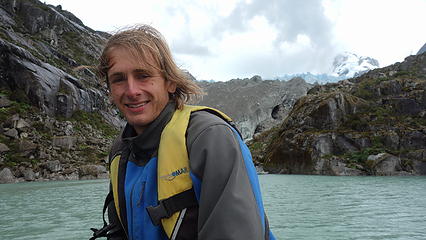
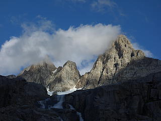
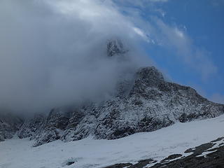
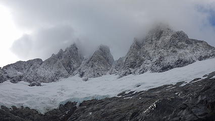
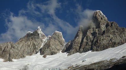
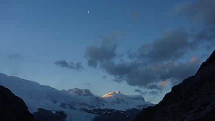
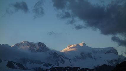
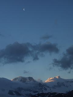
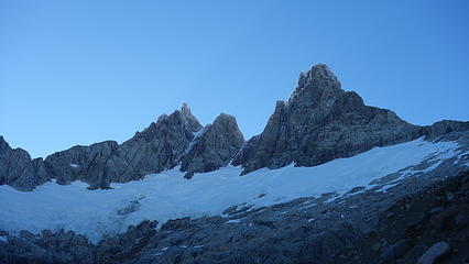
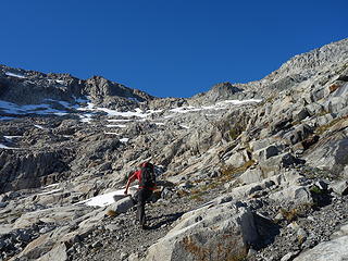
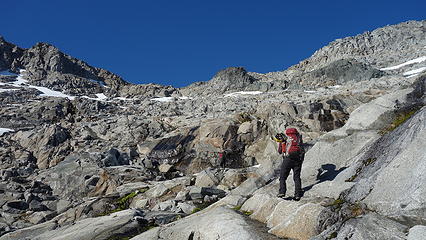
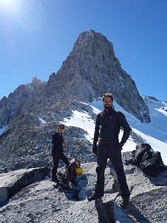
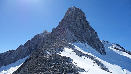
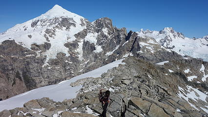
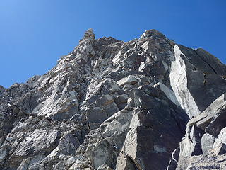
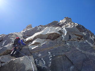
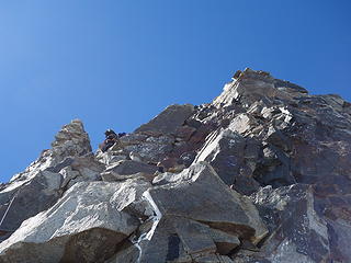
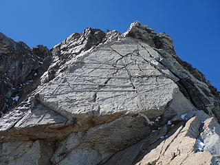
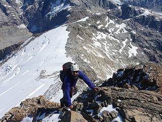
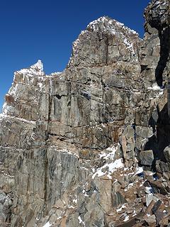
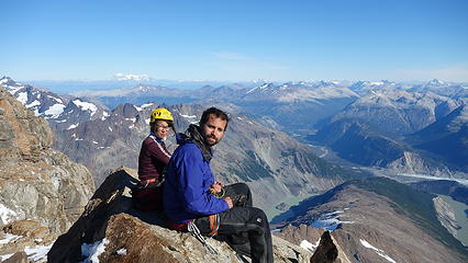
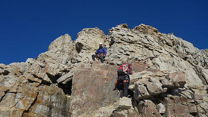
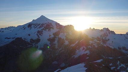
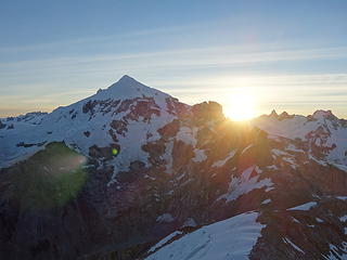
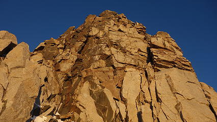
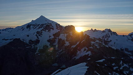
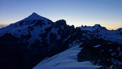
So at 5am we got up, and awoke to clear skies. We were off as soon as we could see from twilight. We began ascending the opposite ridge I explored the previous day, and utilized the ridge coming down directly from Puno Este itself to the right of the tarn. As we gained elevation, the sunrise was stunning, and we grew ever excited to climb. We managed to stay on the rocky ridge the entire way up to the base of the technical portion of the climb. With the beta from Tad's AAJ report, they climbed a short 5.9 route of a few pitches somewhere on the edge of the east face. We never really found exactly where they went so we ascended the most logical way, straight up the SE ridge direct. We solod some low 5th class to surmount the first hump on the upper ridge, where we emerged onto a flat sidewalk. Here we racked up and I led one long pitch up a ramp that cut the face, and made an anchor under a large block on a nice ledge. Leading the second pitch, I thought I would try the final overhang that guarded direct passage to the easy summit scramble just above. I tried at least 5 times backing off every time to surmount the overhang but with nothing but kitty litter above on the ledge, there was no way for me to pull myself completely over. This was at least a 5.10d move.

 
Twilight with Disfiladero in the distance


Puno Este
Puno Este


Taking a break on the beautiful ridge
 
First views of Cerro Arenales
 
More difficult scrambling
 
Beautiful unnamed peak
Scrambling with some exposure!
 
 
Looking west to Puno Oeste


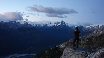
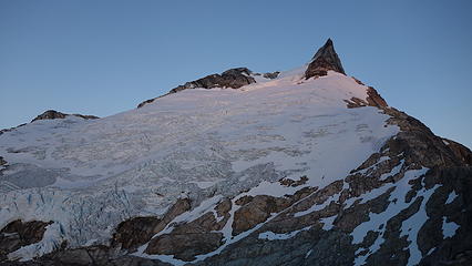
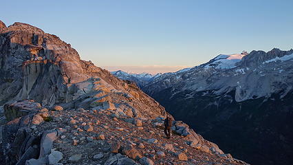
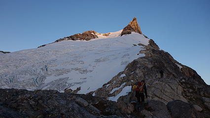
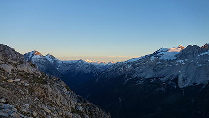
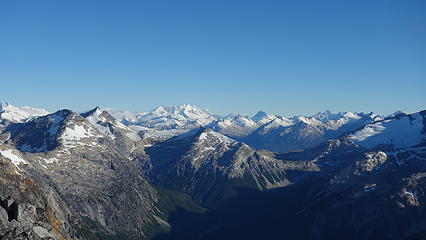
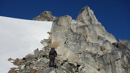
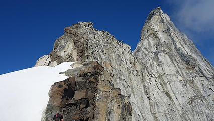
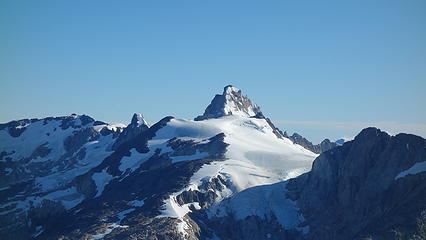
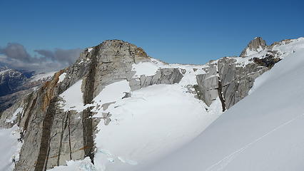
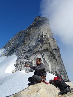
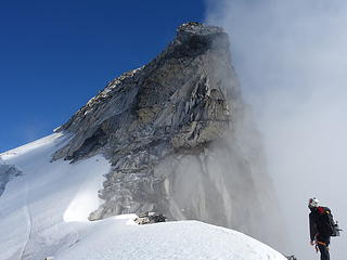
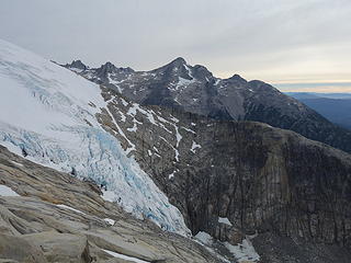
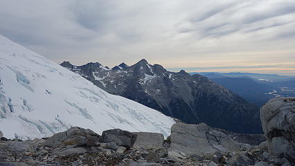
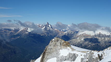
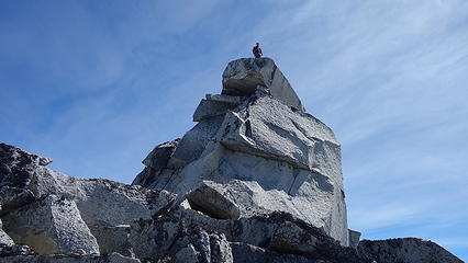
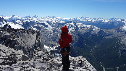
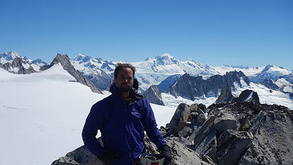
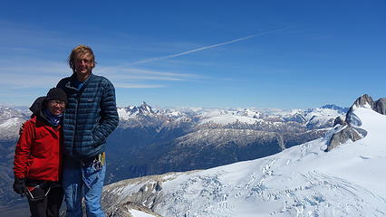
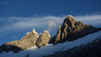
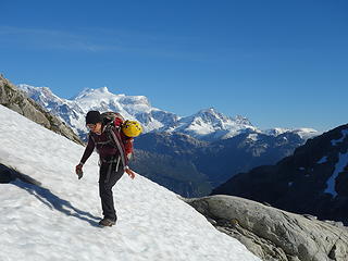
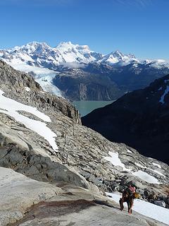
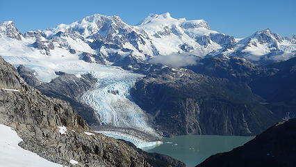
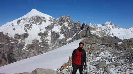
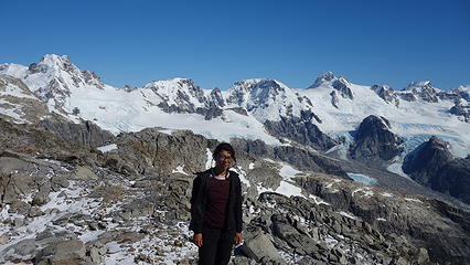
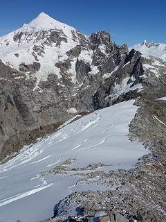
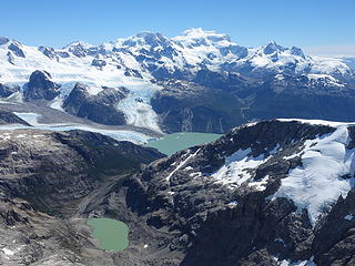
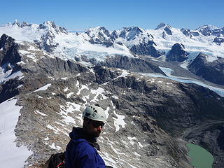
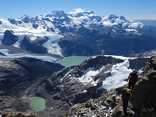
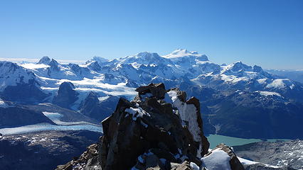
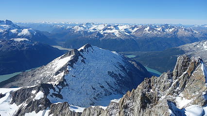
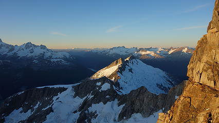
Not wanting to waste anymore time on it, I downclimbed a short ways, traversed right and ascended an easier line on more featured but vertical darker colored rock. This section I figured was more in the 5.7 range. Itai and Elaine followed and we all reached the big ledge. We then scrambled up the final bit and the mountain greeted us with one last difficulty. The last 15 feet to the summit block was a class 4 crack that was in the shade, and therefore covered in a thin layer of fresh snow. Itai and I were able to worm our way up, while Elaine, being shorter climbed up on belay. The summit was a perfect tabletop flat enough for 5 people to take a nap! Views to the west of Cerro Arenales were some of the grandest mountain scenes I have ever witnessed. I thought the stuff in the North Cascades was awe inspiring, with with hundreds of mountains before me, all of which I know never get climbed, I couldn't help but count my blessings to be able to see such terrain few people have ever laid eyes on before.

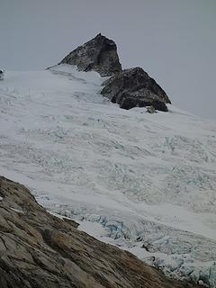
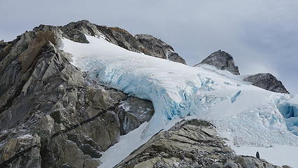
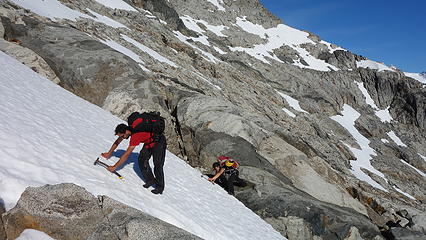
Our descent began and we were able to easily scramble down to the flat part of the glacier separating Puno Este and Oeste. An easy walk across the flat upper glacier brought us to the top of the ridge I explored the previous day, and we began descending. To our shock though, we stumbled across a single aluminum crampon sitting on the talus just as we started going down the ridge. Knowing that Tad and Jim were just here the previous year we figured it was one of theirs, so Itai picked it up and we carried it down. The scramble down got more and more difficult, definitely class 4 in spots until we hit a 40 foot drop. We made a single rope rappel here but unfortunately the rope got stuck under a chockstone at the bottom of the rappel. Itai fought for 15 minutes to free it. Once freed, we continued and reached the top of the serac zone, where we made two double rope rappels. The first off a large horn down to a spot partway down the steepest part, at which point I realized the ropes wouldn't quite reach. So I stopped on a small ledge looking straight down into a huge gaping moat. The only anchor I could make was a single nut in a small crack. Here I anchored in and they met me on the small ledge. I went first with a questionable cam backing up the single nut and gingerly rappelled down the vertical face, and carefully jumped off the wall and over the moat onto the snow. This was one of the scariest raps we all have done.

 
Cerro Arenales is BIG


Beginning the descent
Descending the upper glacier
 
 
Wishing we had time to run over to also climb Puno Oeste


Elaine rapping off just one nut onto the snow


The rest of the descent back down was uneventful. We made a great dinner to celebrate and went to sleep.

The last day would be a repeat of our first day in reverse. We needed to get back to the Balsa before 5 though in order to be able to cross Rio Baker and make it back to Cochrane. Otherwise we would have to spend another night out and I was beyond starving and we were nearly out of food. We made it down from the bushwhack in reasonable time (lots of cursing still occurred) and upon returning to the bikes we noticed one had a flat tire. Thankfully they gave us one spare tube so I quickly changed the tube and warned us all to avoid biking off the track because the thorny grasses would puncture the tires, and if any of us got another flat on the way out we were totally screwed!

We ended up biking the entire way out without any hitchhikes, and since we were making good time, we took the offer from Edwardo, another local homesteader to feed us his homemade stew. He was super nice and took us into his home (which he built) and fed us. Everyone in Chile is just so nice. He informed us it was mostly downhill the rest of the way to Rio Baker, and we made it to the barge with an hour to spare. Once across we met back up with the Austral and did manage to get a ride the 8km back to Cochrane by a very nice guy who actually did speak English. He even joined us for beers at the local brewery later that evening, which I was thrilled to have after such a huge effort to climb one mountain.

 
Departing view
Departing view
Just gross
Just gross
 
Views from X-890 Road
Crossing Rio Baker on the Balsa
 
Annotated route topo of our ascent
Overview map of the area with Puno Este marked

Cerro Agudo - 8665' - West Ridge Class 5.7
​February 2018

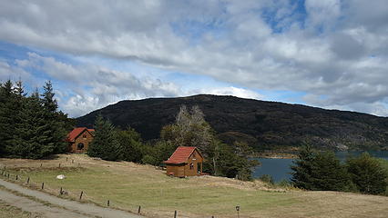
After we returned to Cochrane after climbing Cerro Puno Este, we were completely exhausted and tried to hitchhike the last 8km back to Cochrane on the Austral. Amazingly we were picked up right away by an English speaking Chilean resident who was very interested in our journey. He even shared beers with us later that evening, and we probably received the best recommendation from his than anyone we met on the whole trip. He gave us the contact of a Frenchman named Phillipe, who owns the Terra Luna Resort and Lodge on Lago General Carrera just outside Puerto Guadal. He would be able to assist us in accessing some really remote areas for a reasonable price, utilizing his jet boat tours he normally runs on a daily basis. He is also a mountain climber and was happy to serve us, and allowed us to simply camp on his lawn for cheap instead of paying for an expensive room. Although his services were still expensive, it was worth the price (which I'll describe more about lower down).

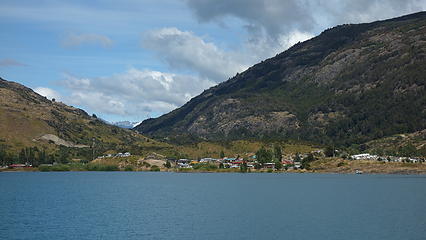
So, the next morning, we took a mini-bus (more like a van) back north and got off in Puerto Guadal, which at first seemed like a tiny, kinda dead little town tucked into a little cove on the big lake, but we would soon find this place was teeming with local life, and was slightly off the tourist track the Austral brings so we also ran into a small climbing scene as well. This is also where Jim Donini (who I mention in part 1), and Ben, who we ran into a few times in the previous weeks, live! It didn't take long for us to find out why they live here either...it really is a special little town kept apart from all the hustle and bustle of tourists like what's found at Puerto Rio Tranquilo, which is overrun by tourists.

After chatting with Phillipe, we came up with a plan and decided that as long as his scheduled jet boat tour that went up Rio Leones the next morning was a go, we would join, and he would drop us off at the southwestern corner of Lago Leones at the mouth of Rio San Tadeo. Although it was raining the next morning, his clients decided to go on the tour and so we packed up our gear, stashed whatever we didn't need for the trip in one of Phillipe's cabins, and organized our food for 6 days. Amazingly, just moments before we were all going to pile up into the jet boat, John, Ricky, and Tad (who we all met up with in Chalten one month prior) raced up right to us in Jim Donini's Jeep with Jim and his wife, and the whole crew of climbers we hung out with in Chalten. Apparently Itai sent a Whatsapp message to John asking him for Jim's contact info so we could ask Jim if that was his crampon we had found on Puno. It just so happened that John and all our friends from Chalten were hanging out at Jim's home for the past few days after they made an attempt on the legendary 1300 meter high NE buttress of San Valentine, which still has yet to even see anyone even get to the base of that route. We ran across Ricky in Guadal while we were grocery shopping, who was climbing with John in Chalten, and on their San Valentine attempt and he later informed Jim we were at Terra Luna. Then, to our complete surprise and without warning, they all just appeared at Terra Luna, unknowing we were just about to leave!

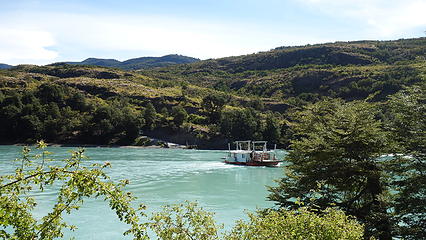
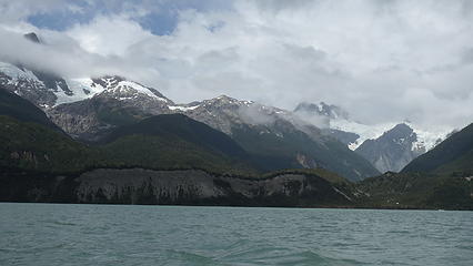
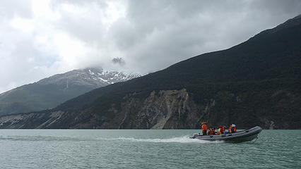
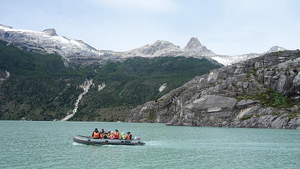
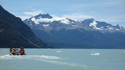
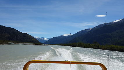
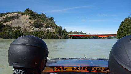
We gladly returned Jim's crampon, who was beyond surprised to run into some new faces and to see his route from two years ago revisited with a new variation. We all chatted for a bit before we boarded the boats and Jim and the gang returned. We all planned to meet up again as soon as we got back however. So off we went in one of the jet boats (my first time riding one!). We made quick time racing north across the west end of Lago General Carrera, and started up Rio Leones. The entire way up this river started calm, but the river soon became narrower and rougher with Phillipe driving the boat through every rapid and obstacle perfectly. The boat ride really was a thrilling experience, complete with a soaking from both rain and splash. At times we were boating up class 5 rapids, and I couldn't believe we didn't hit a rock. Upon asking him if he's ever hit rocks before he laughed with a resounding yes.

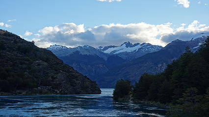
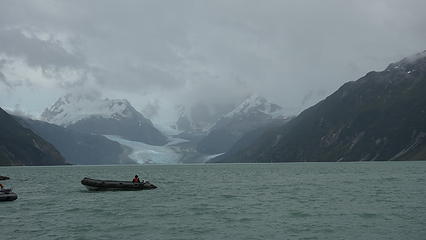
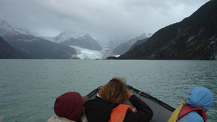
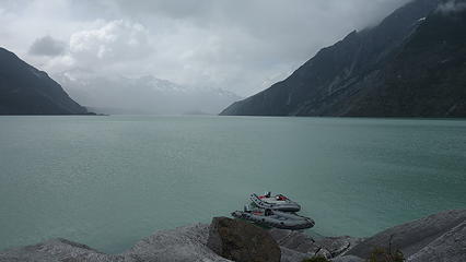
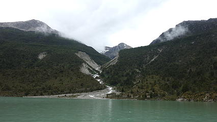
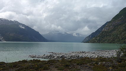
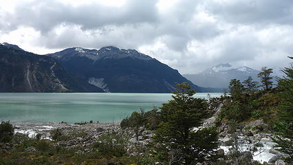
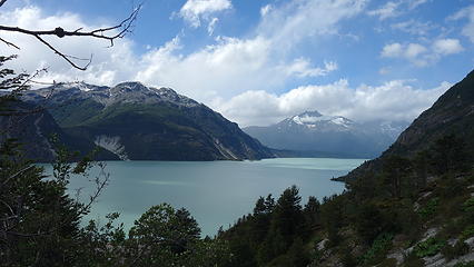
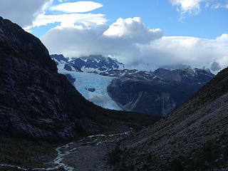
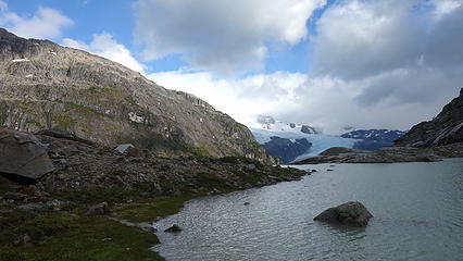
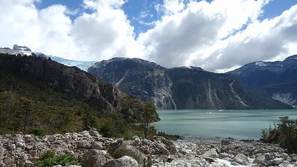
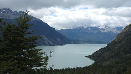
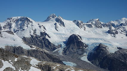
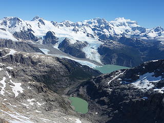
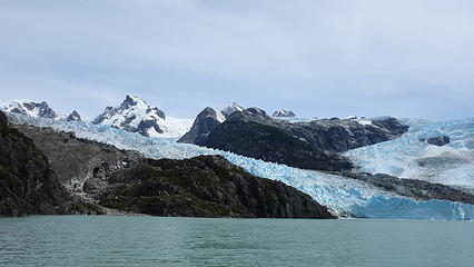
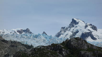
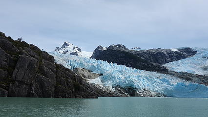
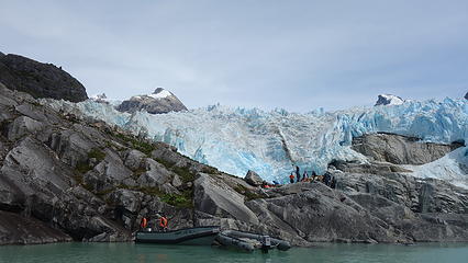
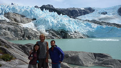
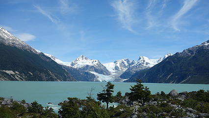
We portaged the jet boats just about a mile from the outlet for the large and brilliantly blue Lago Leones. Here we all (the 3 of us along with the normal tour group) walked a flat trail adjacent the river to the lake where Phillipe had a few smaller floating pontoon motor boats we would then board for the ride to the west end of Lago Leones, where the large XXX Glacier dumps right into the lake, often calving off large chunks of ice. We all ate lunch here, then Phillipe dropped us off with all our gear for 5 days. We said our farewells and began caching half our food along the beach in a hidden location before starting the bushwhack up the right (west) side of the drainage dropping northward from the alpine cirque directly below Cerro Agudo.

Part of the Terra Luna Property
 
Avallano Towers rising high above the lake
 
 
Our jet boat
Our jet boat
 
Lago Leones
Lago Leones
 
 
Cerro Cristal and Tronco


Boating across Lago Leones
Nearing Glacier Leones
First views of Cerro Agudo
 
 
The drainage we would hike up (slopes above and to right side of creek)


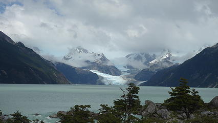
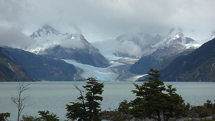
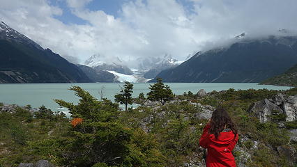
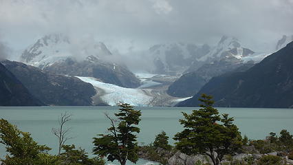
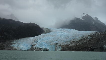
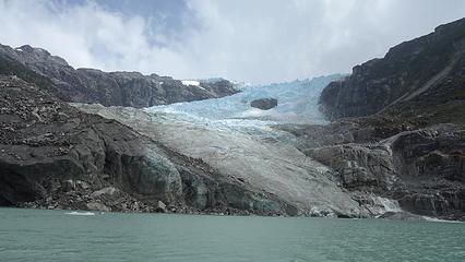
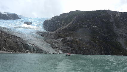
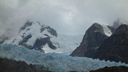
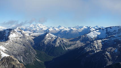
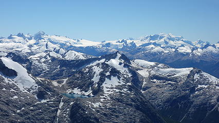
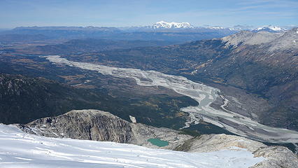
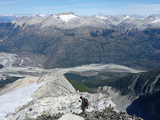
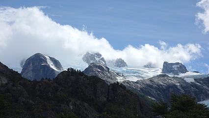
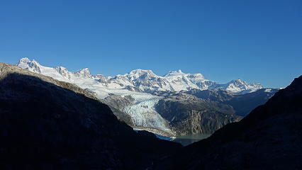
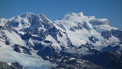
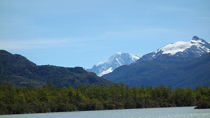
This particular area of the Aysen region of Chile sits directly east of the mighty Campo de Helio Norte (Northern Patagonia Icefield). The three big mountains seen from the east end of Lago Leones (Cristal, Tronco, and Mocho) are all but small rock outcroppings at the edge of the icefield. From the lake, you cannot see the massive icefield looming behind these peaks, however from our later vantage atop Agudo, we got an up close and personal view of one of the wildest places in the Americas.

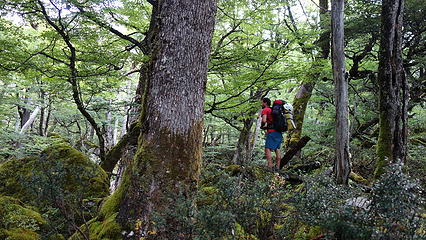
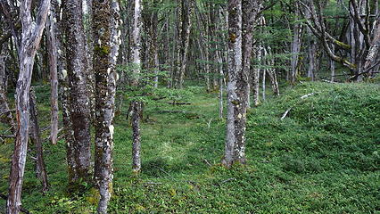
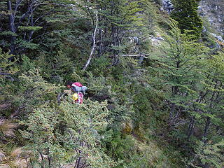
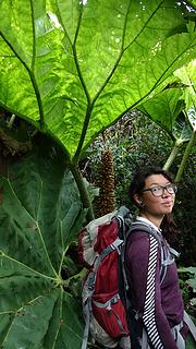
So we began our ascent from our drop-off point, and as we climbed up alongside the creek, we ended up leaving the rocky creek bed too early and cut too far to the right, and found ourselves in some very thick bushes of lenga, calafate and other shrubs. It was very slow going, and morale was lowest when we were forced to cross a small side stream with perhaps the largest leafed plants I have ever seen. Leaves the size of cars growing straight out of the ground in excess of 10 feet tall with thorny stems sometimes 6 inches thick! Luckily they were fairly easy to maneuver through but damn, these were the oddest plants I've ever seen. We struggled for over an hour traversing back to the left until we eventually got to somewhat more open slopes, but still with many thorny Calafate bushes to scratch us up. Eating their tasty berries relieved the pain they caused somewhat.

After about 400 meters of gain from Lago Leones, the terrain leveled out and we entered a more treed forest with less underbrush which was a very nice alternative. We continued up the valley until treeline was reached, and we could now see the remainder of our approach. Due to the heavy rains that fell the previous day, our feet were completely soaked and we still had plenty of boggy terrain to cross and a plethora of other streams to navigate. Eventually we made it to the final headwall just below the alpine tarn we were aiming for, and we scrambled/schwacked another 150 meters up, cutting right to work around a short cliff band and arriving at the beautiful tarn, with Cerro Agudo towering high above. We saw an old small rock wall that was potentially built long ago near the lake shore and set up the tents. We spent an additional hour or so building the wall up (this was becoming normal practice due to the Patagonia winds) and enjoyed a nice dinner. We communicated with Phillipe regarding our progress with the Inreach, and he informed us that weather was going to be taking a nosedive for a while. We decided to play it by ear and if it was raining in the morning we would simply wait.

Beginning the ascent
 
Horrid bushwhacking
Horrid bushwhacking
 
Finally some trees!
Finally some trees!
Peaceful forest
Peaceful forest
Cerro Agudo
Cerro Agudo


Cannot wait to climb it
 
View back towards Glacier Leones and Cerro Mocho
 
 
Nice camp spot
Nice camp spot
 
Twilight over Cristal, Tronco and Mocho


Unfortunately, it rained all the next day, and the day after that...We were forced to make a tough decision, and elected to forgo plans to move to the opposite side of Lago Leones and try for Cristal, and instead continue to wait at the base of Agudo. After sitting in the tent for two straight days, we awoke on the third day to halfway decent skies but still not good enough to climb. We used this day to return back to the lake shore, back down the bushwhacking and retrieve our remaining food supply. We then of course had to hike back up to camp, but we nailed the best route this time around with only minimal class 4 bushwhacking. It was at the very least nice to get the legs moving after two days of laying on the ground doing nothing.

Halfway decent weather!


Fresh snow on Agudo...hope it melts!
 
 
Back at Lago Leones for food stash
 
Now this was a really big leaf
Cerro Cristal at center


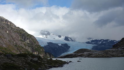
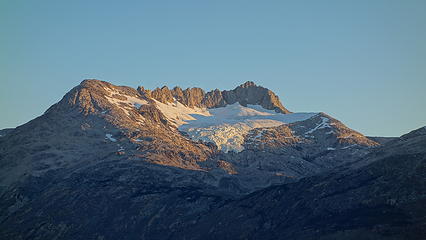
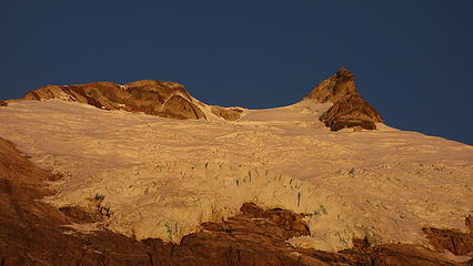
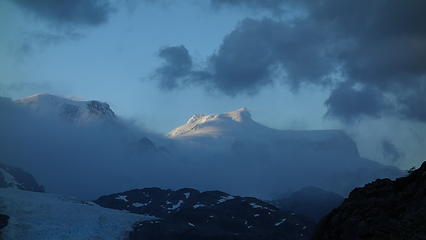
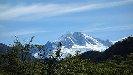
With high hopes for better weather the next day, we cooked a fresh dinner and went to bed early with the alarm set for 5am. To our dismay though, it rained all night and didn't stop at all throughout the next day. Ugh, yet another day sitting in the tent. We messaged Phillipe once again to ask about weather updates, and he responded with exciting news that high pressure was moving back in, and we should be good to go the next day. Excitement and stoke was driven back inside us as we saw the glow of sunset colors hitting Cerro San Valentine and watched the clouds rise, and depart. Above us, the fiery sunset colors provided a dazzling show on Agudo, and we once again studied the route we would take, directly up the west ridge (right skyline from our vantage at camp). It was a chilly evening but that didn't stop me from taking copious amounts of photos!

Clearing on Cerro Agudo
 
Clouds slowly departing over the northern Patagonia icefield
 
 
San Valentin finally shows herself. This is the highest mountain in all of Patagonia


Excitement so high I barely slept


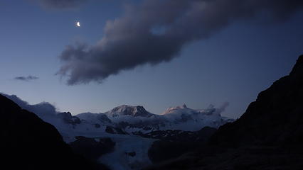
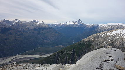
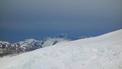
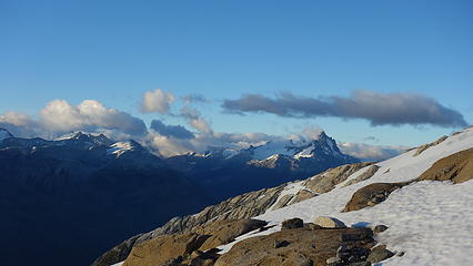
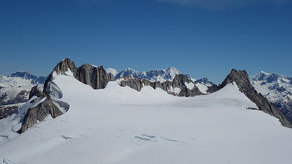
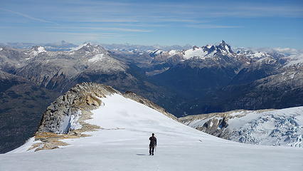
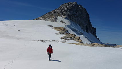
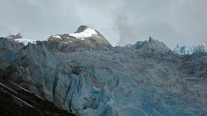
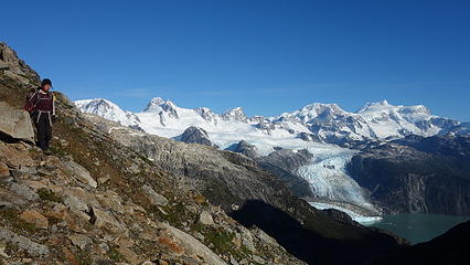
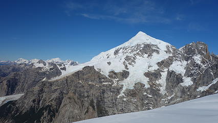
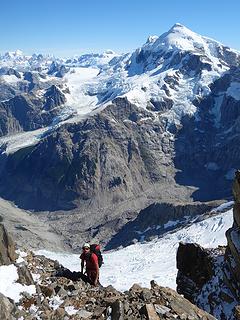
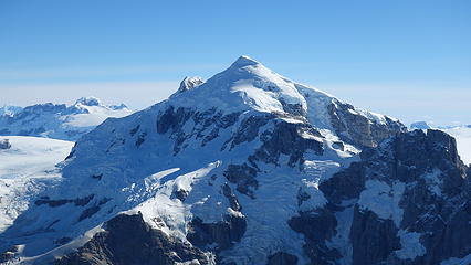
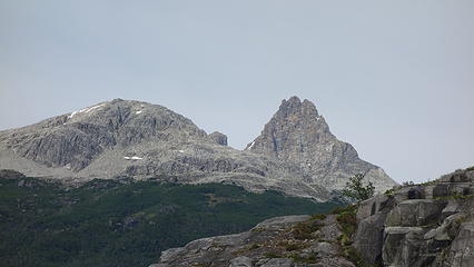
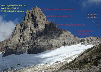
By 6:30am we were off and beginning our ascent under clear skies. We couldn't help but admire the gorgeous reflection of the sunrise hitting San Valentin and the icefield. The climb started by scrambling up some old moraine complete with hard steep scree and lots of talus for about 150 meters, then we traversed left on a wide bench and into the glacier slabs that have been recently exposed from the melting of the many smaller alpine glaciers that used to completely flank these satellite peaks of the icefield. Scrambling these slabs was much more enjoyable, and we trended left for a class 3-4 gully that allowed access past the cliff band guarding the crest of the west ridge. We cairned our way up this gully and beyond to the ridge crest since this was crucial to the route down and hard to see from above. This ended up proving to be a total lifesaver. When we stood atop the ridgecrest, I couldn't believe my eyes. Before me lie a view even grander than the summit of Puno Este...I couldn't believe it could get any better but it did. We were 850 meters above the tarn where we camped and we could really see the sheer size of the icefield to the west, and got a much better view of the surrounding peaks like Cerro Hyades, Cono Helado, San Valentine and we even saw Puno way in the distance to the south! We took a nice break here to admire the beauty, and look for future routes.

Sunrise on San Valentine
 
Cannot get enough of this beauty
 
 
West ridge is the right skyline


The higher we went the bigger the mountains looked
Scrambling up the glacier slabs
 
 
More glacier slabs
More glacier slabs
San Valentine and Lago Leones


Cerro Hyades
Cerro Hyades


Looking ahead at our route up Cerro Agudo from where we crested the west ridge


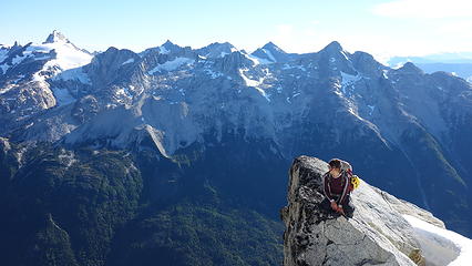
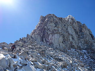
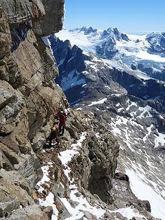
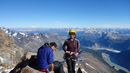
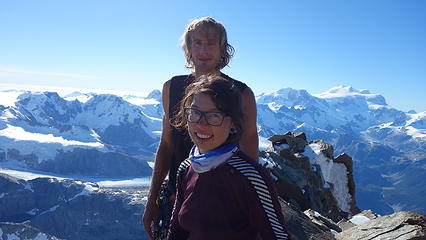
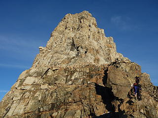
From this point, the climbing really began, we knew from studying the route from camp there was three steep rises (or steps) on the ridge with easier scrambling terrain between them. We quickly made it to the first step and scrambled up a hidden 4th class gully that was covered in 4-6 inches of fresh snow. Soloing this with the snow made it low 5th class for sure, and really added to the spice to start out the climb. Beyond there was a stretch of class 2-3 scrambling until the base of the 2nd step, which we broke out the ropes for. I led a full 60m pitch, followed by Itai leading another 40m pitch on mostly class 5.6 terrain which dumped us off on a very large and flat section of ridge. At one point it did get quite narrower however and added difficulty to what at first looked like an easy walking section. We then reached the base of the third step, which we scrambled up blocky terrain along the ridge until we were no longer comfortable soloing. At a vertical 5.7 wall, we again roped and Itai led through this obstacle, which got a little thin at the top but still very manageable, and solid for the high alpine. I then led another pitch above that going up a chimney that was still caked in fresh snow, albeit melting in the warm sun. I got pretty soaked leading a scary 5.7 area with few good holds, all of which were very wet. The ascent finished with a wildly exposed ridge traverse up to the summit of the slightly lower west peak of Cerro Agudo.

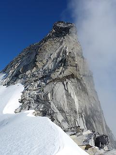
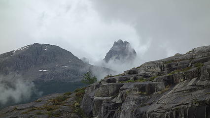
It was already abut 5pm and while I desperately wanted to tackle the remainder of the traverse to the true summit, we would not have the time. To finish the entirety of the west ridge would require a single rope rappel off the west peak into a notch, leave the rope (to allow prussiking on return), then make a very scary traverse around a gendarme to a second notch, where a fall would be 100% fatal, then climb a class 3 gully maybe 100 feet or so to the summit. Of course the traverse would have to be repeated on return likely adding at least 2 hours round trip from the summit of the west peak, which would force us to bivy there, something we weren't prepared for. This finishing traverse we were not able to see from camp at the tarn below. We ate a quick snack and congratulated one another on a fine ascent, then had to start descending.

 
Ascending the first of 3 steps with fresh snow
 
 
Approaching the start of the 2nd step
Climbing the 2nd step
 
 
Our camp way down there
 
 
A nice slab to climb


Traversing ledges looking for the best route


Cerro Hyades
Cerro Hyades
Elaine on the summit of the west peak


We retraced our route down, building an anchor every rappel we made (there were no signs of any previous ascents on this ridge). Just as the sun set behind the icefield we finished our last rappel and made it back to the lower ridge where we began descending back down the slabs. It got dark just as we dropped off the ridgecrest, and we struggled very hard to find our cairns, but managed to follow them to the critical 4th class gully that brought us down into the lower basin, however this wasn't the hardest part. There was no moon and our headlights weren't the greatest since we hadn't ever used this on the entire trip yet. Plus, in the lower basin we didn't place any cairns so we were more or less blindly descending in the general direction we thought we needed to go, knowing we had to find the long ledge allowing the only passage from the glacier slabs back down to the moraine slopes to the tarn. If we descended too quickly we would reach steep cliffs that dropped down to the opposite side of the tarn. After hours of slowly walking down, we were losing our mental capacity to continue searching our way through the darkness. Our progress down was very slow, but when we were about to give up and sit the rest of the night out on a rock, Itai found one of the cairns he built earlier that morning directing the way to the wide ledge we needed to traverse. From there we knew where we were again and safely made the final descent down the talus to the lake, where we simply crawled inside the tents and went right to sleep, totally spent. It was 1:30am.

Rapping down
Rapping down
 
 
Sun setting behind Hyades


The next morning, as much as I would have liked to climb something else since it was another beautiful day, we messaged Phillipe and requested three seats be saved on the boat for us to be picked up. We were all too exhausted to try another climb. Despite how amazing it was, I had that nagging felling that we didn't quite reach the true summit, and we waited through 4 days of bad weather for it, but in the end it was still worth it, and I concluded I will most certainly be back to this beautiful area.

We packed up and started to descend back to Lago Leones, and Phillipe said he will be there to pick us up around 1:30pm. We made it to the lake shore with an hour to spare and enjoyed the stashed beers we had placed in the lake water 6 days prior. Unfortunately one of them had mysteriously disappeared though...

Phillipe arrived and took us around the bend to the normal lunch spot for his clients right next to the calving Glacier Leones, and we were greeted by a nice group of tourists who were interested to hear about our trip.

Departing view. I think I cried a little leaving this place
 
 
Rare sighting of a Heumel; This is the only large wild animal we saw in Patagonia
 
 
Back at lunch counter with the tourists and Phillipe
 
 
Last view of Agudo from the boat ride out


Jetboating on Rio Leones


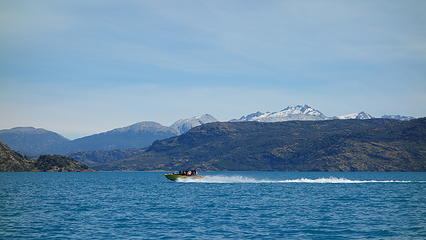
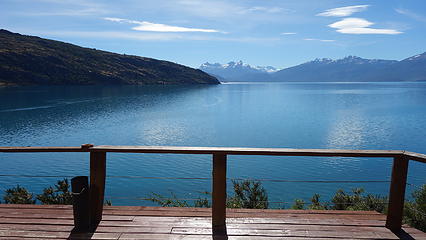
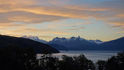
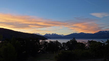
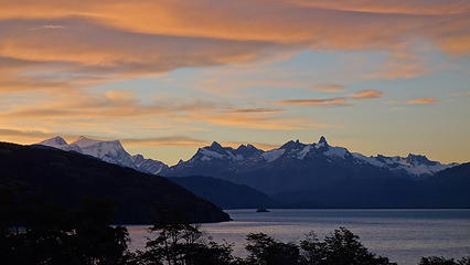
The boat ride back this time around was much more scenic due to the perfectly clear skies. We met an Israeli/Chilean woman named Ruth who was helping out Phillipe for the day who was particularly interested in our trip, as she had a cabin right next door to Jim Donini! She allowed us to stay there upon us returning to Terra Luna, where we could relax and enjoy the beautiful lakefront views her cabin offered of San Valentine and many surrounding peaks. After chatting with Jim when we got back, and thanking Phillipe for his amazing service and hospitality, we made our way down the road a couple miles to her cabin. If there was one thing I could describe as paradise, that cabin was it. Sipping wine on the porch there with Lago General Carrera and Valentine as a backdrop at sunset was the best possible way I could have imagined to celebrate such a fine trip.

Sunset from our little home away from home next door to Jim Donini


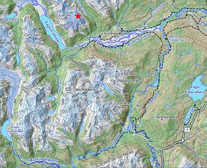
See the images below for more details regarding the route we took.

Overview map of the Valle Leones area
Annotated route topo


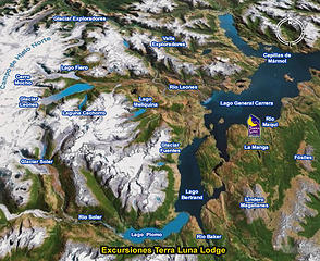
For additional reference, Phillipe charged each of us $300 USD round trip for the boat service. Expensive compared to the rest of our trip, but worth it overall.

Proudly powered by Weebly