LEMKE CLIMBS
  • About
    • Whats New
    • 2019 Goals/Wishlist
    • Contact
  • Washington
    • North Cascades >
      • Sahale Peak, Boston Peak
      • Eldorado Peak, Klawatti Peak
      • Black Peak
      • Forbidden Peak West Ridge
      • Primus Peak Attempt
      • Big Snagtooth
      • Liberty Bell Beckey Route
      • Burgundy Spire North Face 5.8
      • Ragged Ridge - Katsuk, Kimtah and Cosho Peaks
      • Colfax Peak
      • South Early Winters Spire via SW Buttress
      • Chilliwack Mini-Slam
      • Mesahchie Peak
      • Inspiration Traverse
      • Mount Shuksan Ski
      • Full Pickets Traverse
      • Mount Goode NE Buttress & Storm King
      • Mount Baker North Ridge WI3
      • Snowfield Peak
      • Lincoln Peak
      • Silver Star Mountain
      • Mount Buckner & Horseshoe Peak
      • Azurite Peak
      • Tower Mountain & Golden Horn
      • Mount Logan
      • Custer Ridge & Easy Mox
      • Mazama Dome
      • Sherman Peak
      • Mount Ballard
      • Southern Pickets Traverse
      • Corteo Peak
    • Glacier Peak Wilderness >
      • Buck Creek Pass, Cloudy Peak, Spider Gap
      • Dome Peak, Spire Point
      • Mt. Maude and Seven Fingered Jack
      • Mount Formidable NE Face 5.6 Second Ascent
      • Dumbell and Greenwood Mountains
      • Glacier Peak Wilderness Mountain Massacre
      • Clark and Luahna Peaks
      • Sinister Peak
      • Chiwawa Mountain
      • Tupshin & Devore Peaks
      • Buck & Fortress Mountains
      • Glacier Peak
    • Olympic Peninsula >
      • Buckhorn Mountain
      • Flapjack Lakes Hike
      • Grey Wolf Peak, High Divide Trail
      • Mount Ellinor
      • Mount Constance West Arete
      • Mount Olympus
    • Alpine Lakes Wilderness >
      • Chikamin Peak
      • PCT - Snoqualmie to Pete Lake
      • Foss Lakes Hike
      • Necklace and Tank Lakes
      • Enchantments Day Hike
      • Granite Mountain (Snoqualmie)
      • Colchuck Peak
      • Cannon, Enchantment and Stuart
      • Ingalls Peaks
      • McClellan Peak
      • Dragontail Peak
      • Web Mountain
      • Mount Index Attempt
      • Snow Creek Wall Orbit 5.8+
      • The Tooth South Face
      • Eightmile Mountain
      • Argonaut Peak NE Couloir
      • Little Annapurna South Face 5.5
      • Snow Creek Wall Outer Space 5.9
      • Cashmere Mountain
      • Sherpa Peak North Ridge 5.8
      • Chair Peak NE Ridge
      • Lichtenburg Mountain
      • Mount Index
      • McClellan Butte
      • Chimney Rock
      • Alpine Lakes High Route
    • Pasayten Wilderness >
      • The Craggies
      • Tiffany Mountain
      • Pasayten Mini-Slam
      • Remmel Group
      • Jack Mountain
      • Robinson Mountain
      • Monument Peak Group
    • Mountain Loop Highway >
      • Vesper Peak
      • Mount Dickerman
      • Sloan Peak West Face 5.8
      • Mount Forgotten
      • Whitehorse Mountain
      • Gothic Peak
    • Lake Chelan Sawtooth Wilderness >
      • Star, Courtney, and Grey Peaks
      • Hoodoo Peak and Raven Ridge
      • Abernathy Peak
      • Mount Bigelow
      • Reynolds Peak
      • Oval Peak
      • Gardner Peaks
      • Chelan Sawtooth Trio
    • Southern WA >
      • Mount Adams
      • Mount Rainier - Emmons Route
      • Mount Saint Helens
      • Goat Peak
      • Lane Peak, Plummer Peak (Tatoosh)
      • The Unicorn (Tatoosh)
      • Little Tahoma
    • WA Rock and Ice Cragging >
      • Index Town Walls
      • Vantage
      • Mount Erie
      • Exit 38
      • Leavenworth
  • Colorado
    • San Juan Mountains >
      • Mount Sneffels Lavender Snow Climb
      • Uncompahgre, Matterhorn Peaks
      • Redcloud, Sunshine Peaks
      • San Luis Peak
      • Vermilion, Fuller Peaks
      • Stewart Peak, Baldy Alto
      • Jones, Niagara, American Peaks
      • Wetterhorn Peak, Handies Peak
      • Wilson Group
      • Arrow Peak
      • Mount Sneffels SW Ridge
      • Jagged Mountain, Chicago Basin
      • Teakettle Mountain
      • Dallas Peak
      • Vestal Peak Wham Ridge, Greystone Peak
      • Organ Mountain
      • Phoenix Peak
      • Half Peak
      • Point 13832 Group
      • Golden Horn
    • Elk Mountains >
      • Four Pass Loop
      • Castle, Conundrum Peaks
      • Snowmass Mountain
      • Cathedral Peak
      • South Maroon Peak
      • The Pyramids
      • North Maroon Peak, Sleeping Sexton
      • Capitol Peak, Mount Daly
      • Malemute Peak
      • Hagerman Peak
    • Sangre de Cristo Mountains >
      • Blanca Peak, Ellingwood Point
      • Challenger Point
      • Mount Adams
      • Spread Eagle Peak
      • Humboldt, Obstruction, Columbia Peaks
      • Mount Lindsey, Huerfano Peak
      • Little Bear Peak
      • Crestone Needle Ellingwood Arete
      • California Peak
      • Crestone Peak North Buttress
      • Operation Dark Snake
      • Kit Carson Mountain
    • Sawatch Mountains >
      • Iowa Peak
      • Point 13,618 - Hunky Dory Lake
      • Gold Dust Peak, Notch Mountain
      • Mount Jackson
      • Mount Belford
      • Shavano, Tabeguache Peaks
      • Mount Antero, Cronin Peak
      • Twining Peak
      • Mount Massive
      • Casco Peak
      • Mount Huron
      • Mount Elbert
      • Mount Oxford
      • Mount Hope
      • Mount Yale
      • Lackawanna Peak
      • Mount Columbia
      • La Plata Peak
      • Rinker and Twin Peaks
      • Bull Hill, Mount Princeton
      • Missouri Mountain
      • Mount Oklahoma
      • French Mountain
      • Mount Ouray
      • Grizzly A, Garfield Peaks
      • Mount Harvard
      • The Three Apostles
      • Emerald Peak
      • Holy Cross
    • Greater Park Range >
      • Kneeknocker Pass, Piney Lake
      • Drift Peak
      • Sherman Peak, Dyer Peak
      • Gore Range Traverse
      • Quandary Peak
      • Pacific, Atlantic Peaks
      • Clark Peak
      • Crystal Peak, Peak 10
      • Fletcher Mountain
      • The DeCaLiBron
      • Loveland Mountain
      • The Mosquito Traverse
      • Mount Arkansas
      • Clinton Group
      • Eagles Nest, Peak C
      • North Star Mountain
      • Peak X
      • Wheeler Mountain
    • Front Range >
      • Mount Evans, Spalding
      • Mount Bierstadt
      • Mount Parnassus, Bard Peak
      • Cupid, Sniktau, Grizzly D Peaks
      • James Peak
      • Mount Silverheels
      • Grays and Torreys Peaks
      • Mount Edwards
      • Mount Flora, Longs Peak
      • Square Top Mountain
      • Petit Grepon South Face 5.8
      • Mount Meeker Dreamweaver Couloir
      • Santa Fe Peak
      • The Citadel & Pettingell
    • Colorado Ice Climbing >
      • Lincoln Ice Falls
      • Ouray Ice Park
      • Avocado Gully and The Drool
      • Hidden Falls
    • Colorado Rock Climbing >
      • Eldorado Canyon
      • The Flatirons
      • North Table Mountain
      • Shelf Road
      • Colorado National Monument >
        • Independence Monument
  • Wyoming
    • Wind River Mountains >
      • Gone With the Winds
      • Union Peak - Solar Eclipse
      • Wind River Peak
      • Wind River Slam
    • Teton Range >
      • Grand Teton Owen Spalding 5.4
      • Mount Owen Attempt
    • Wyoming Absarokas and Gros Ventre Range >
      • Jackson Peak
      • Francs Peak
    • Yellowstone National Park >
      • Top Notch Peak
    • Bighorn Range and Great Divide Basin >
      • Boars Tusk
      • Loaf Mountain
      • Cloud Peak
      • Black Tooth Mountain
    • Devils Tower
    • Cody Rock and Ice Climbing
  • Montana
    • Beartooth Mountains >
      • Whitetail Peak Group
      • Beartooth Mountain
      • Spirit Mountain Group
      • Mount Peal
      • Granite Peak Group
      • Castle Rock Group
      • Castle Mountain NE Couloir
      • Mount Inabnit and Sylvan Peak
      • Mount Hague South Slopes
      • Mount Villard and The Granite Peaks Traverse - 5.4
      • Spirit Mountain NE Ridge - 5.4
      • California Ice WI 4
      • The Ramp 5.8
      • Linea Alba 5.10d
      • Iceberg Peak
      • Metcalf Mountain North Rib 5.8
      • Villard Spires HP West Ramp
      • Cairn Mountain
      • Snowbank Mountain
      • Mount Wood Group
      • Bears Tooth
      • Glacier Peak Catch-a-Sunrise FA
    • Montana Absarokas & Gallatin Range >
      • Black Mountain
    • Southwest Montana Ranges >
      • Sacajawea Peak
      • Arrow Peak
      • Koch Peak
      • Saddle Peak
      • Baldy Mountain
      • Sphinx Mountain
    • Glacier National Park >
      • A Taste of Glacier National Park
      • Divide Mountain
    • MT Rock and Ice Climbing
  • Utah
    • Uinta Mountains >
      • Kings-Emmons Ridge Run
      • Hayden Peak
      • Iron Hayden Wall Rock Climbing
    • Wasatch Range >
      • The Sundial Eleventh Hour 5.8
      • Mount Timpanogos
    • San Rafael Swell >
      • Ramp, Cistern Canyons
      • Salt Wash, Black Mountain, Moroni Slopes
      • Ding, Dang Canyons
      • Little Wild Horse, Bell Canyons
      • Quandary Canyon
      • San Rafael Knob
      • Miners Hollow (Knotted Rope Canyon)
      • Temple Mountain
      • Chimney Rock
      • Bottleneck Mesa
      • Window Blind Peak
      • Lower Baptist Draw & Upper Chute Canyon
    • Capitol Reef National Park >
      • Cathedral Valley Tour
      • Sheets Gulch
      • Halls Creek Narrows
      • Brimhall Canyon and Strike Valley Overlook
      • George Benchmark
    • Moab Area, Canyonlands, Arches >
      • Maze District
      • Needles District
      • Maze District
      • White Rim Trail Biking
      • Elephant Butte, Bullwinkle Tower and Lizard Rock
      • South Six Shooter
      • Elephant Canyon
      • Parriott Mesa
      • Ancient Art
      • Castleton Tower North Chimney 5.8
      • Klondike Bluffs
      • Mount Peale & Tukuhnikivatz
    • Robbers Roost Country >
      • Horseshoe Canyon, Goblin Valley
      • Bluejohn Canyon
      • Happy Canyon Narrows
      • Shenanigans, Leprechaun Slots
      • Larry Canyon
      • Merry Piglet Slot
      • Lower Maidenwater Canyon, Turkey Knob
      • Morocco Canyon
      • Monkey Business Slot
      • Hog Canyon Slots
      • Upper Maidenwater Canyon Slots
      • Mount Ellen
      • Buck Canyon
      • Point 4906
      • Alcatraz Canyon
      • Hard Day Harvey Slot
      • Mount Ellsworth
      • Good Day Jim Canyon
      • White Roost Canyon
      • Upper Stair Canyon
    • Escalante National Monument >
      • Phipps Canyon and Arch
      • Red Breaks Slot
      • Dry Fork Slots, Coyote Gulch
      • Little Death Hollow/Wolverine Canyons
      • Egypt 3 Slot
      • Egypt 1 Canyon
    • Zion/Bryce >
      • Ataxia Tower Ashtar Command 5.9
      • Mount Kinesava Cowboy Ridge
      • Birch Hollow
      • Aires Butte
      • West Temple
      • Mystery Canyon
      • Crazy Streak
    • Cedar Mesa Region/Valley of the Gods >
      • Eagle Plume Tower Eagle Feather 5.10b
  • California
    • High Sierras, Southern CA Ranges >
      • Telescope Peak, Manly Beacon
      • Tahquitz Rock Whodunit 5.9 - June 2016
      • Tahquitz Rock Long Route 5.9 - July 2016
      • Palisade Traverse
      • White Mountain
    • Yosemite National Park, Central CA
    • Northern CA Cascades >
      • Lava Beds National Monument - August 2015
  • Oregon
    • Oregon Volcanoes >
      • Three Fingered Jack
      • Mount Scott
    • Blue Mountains >
      • Twin Peaks
    • Trout Creek Rock Climbing
  • Alaska
    • Eagle Peak and Mount Ewe
    • Jatt Peak and Portage Pass
    • Rainbow Peak
    • Mount Brooks Attempt
    • Arrigetch Peaks Trek
    • Ab Mountain Hike
    • South Suicide Peak
    • Mount Hunter West Ridge Attempt
    • Cantata Peak Attempt
    • East Twin Peak
    • Mount Alice
    • Crow Pass and Hope Point Hikes
    • Indianhouse Mountain Attempt
    • Lynx Peak
    • Harding Icefield Hike
    • Hatcher Pass and Grapefruit Rocks Climbing
    • Mount Sanford
    • Mount Hunter West Ridge
  • Nevada
    • Ginger Cracks 5.8
    • Mescalito Dark Shadows 5.8
    • Birdland and Olive Oil
    • Frogland 5.8
    • Johnny Vegas 5.8
    • Schaeffer's Delight & Triassic Sands
    • Solar Slab - 5.6
  • British Columbia
    • Mount Matier
    • Taiya Peak
    • Bugaboo Spire NE Ridge
    • Mount Sabine Easy Honey 5.10b
    • Mount Sir Donald NW Ridge Attempt
    • Black Tusk
    • Squamish Ticks
    • Slesse Mountain NE Buttress
  • Alberta
    • Mist Ridge Hike
    • Mount Temple Attempt
    • East Wendell Peak
    • Loder Peak
    • Tower Mountain Attempt
    • The Rimwall
    • Mount Yamnuska Directissima 5.9
    • Mount Lawrence Grassi
    • Mount Lorette
    • Roche A Perdrix
    • Mount Edith Cavell East Ridge 5.3
    • Mount Louis Kain Route
    • Eiffel Peak
    • Canadian Rockies Ice Climbing
  • Other States
    • Arizona >
      • Grand Canyon Bright Angel Trail
      • Beanfest at Cochise Stronghold
      • Baboquivari Peak
      • Humphreys Peak
    • New Mexico >
      • Philmont Trek August 2008
    • Yukon >
      • Canyon Peak
  • International
    • Mexico & Central America >
      • Mexico - Pico de Orizaba, Izta - March 2012
      • Guatemala Volcanoes
    • South America >
      • An Introduction to Patagonia
      • Cordillera Blanca - Tocllaraju and Urus
      • Nahuel Huapi National Park & The Frey
      • Exploring Pucon and Lanin Volcano
      • Cordillera Blanca - Ishinca Peak and Artesonraju
      • Cordillera Blanca - Quitaraju & Alpamayo
      • Exploring Southern Peru
      • Cerro Helio Azul & Tronador Attempt
      • Aguja Guillaumet Amy Couloir
      • Cerro Puntado & Palo
      • Cerro Colorado
      • Cerro Puno & Agudo
      • Cerro Trinidad Attempt
      • Volcan Quetrupillan
      • Cerro Placas
      • Nevado de Acay
      • Pequeno Alpamayo
      • Huayna Potosi
      • Illimani
      • Chiaro de Luna
    • Oceania >
      • Exploring New Zealand's South Island
      • Puncak Jaya
      • Mount McPherson and Talbot
      • Single Cone
      • Mount Cook
      • Mount Aspiring
      • Manakau
    • Central Asia >
      • Kyrgyzstan 2021
  • Sorted by Year
    • 2008 Trip Reports
    • 2009 Trip Reports
    • 2010 Trip Reports
    • 2011 Trip Reports
    • 2012 Trip Reports
    • 2013 Trip Reports
    • 2014 Trip Reports
    • 2015 Trip Reports
    • 2016 Trip Reports
    • 2017 Trip Reports
    • 2018 Trip Reports
    • 2019 Trip Reports
    • 2020 Trip Reports
    • 2021 Trip Reports
  • Vanlife
    • Conversion Journal >
      • Floor Installation
      • Folding Bed
      • Coffee Table
      • Thinsulate Installation
      • The Couch
      • The Wardrobe
      • Bookshelf
      • Water System
      • Electrical System
      • The Pantry
      • Refrigerator
      • Tire Upgrade
      • Heating System
      • Composting Toilet
LEMKE CLIMBS

Huayna potosi

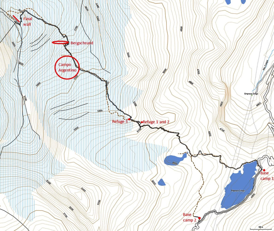
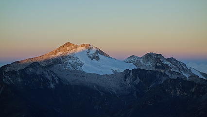
Huayna Potosi - 19974' - East face
​April 2018

My apologies it's been awhile since I posted about last years 4 month South America journey, but alas, I have the time to write once again! 

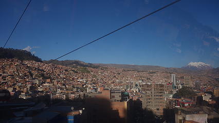
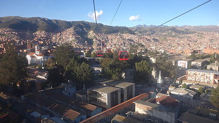
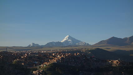
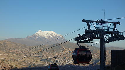
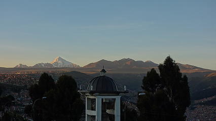
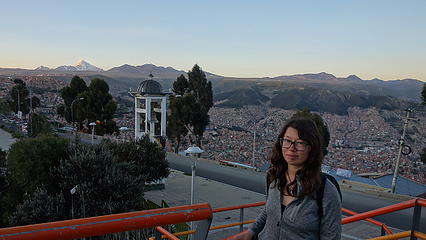
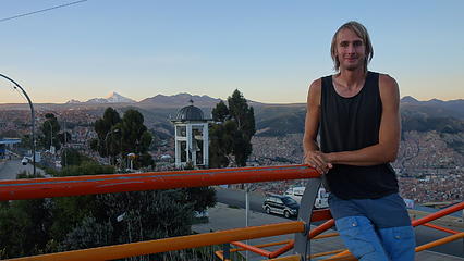
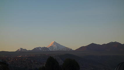
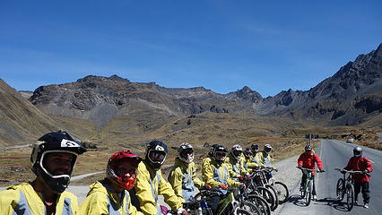
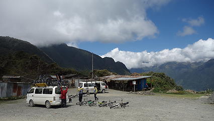
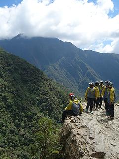
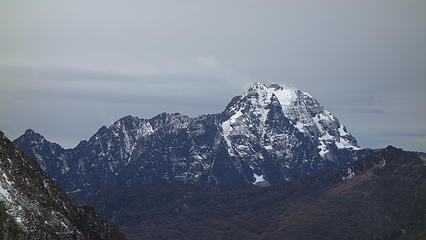
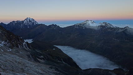
After climbing Pequenyo Alpamayo, I took a small break from climbing and signed up for the inclusive bike tour down the famous "Death Road" (North Yungas Road) while Elaine opted for a more relaxing day and stayed in La Paz. We roamed around town that evening after returning to La Paz, took one of the public transportation gondolas to El Alto and watched the sunset over Huayna Potosi and Illimani (which would be our final objective). The view of the mountains from La Paz truly is stunning. This city really grew on me in the time I was there. The gondolas for one, were only 3 Bolivianos (50 cents!) I figured we had to do it haha! Early in the morning, I hopped on their shuttle which picked me up right from my hostel (I signed up the night before) and we drove to the top of the pass above the city on Bolivia National Highway 3, at an elevation of 4650 meters. Here we stopped, unloaded all the bikes and donned the windbreaker jackets they provided us (it was pretty chilly at this elevation) and the guides gave us a safety briefing. The mountain bikes we were provided with were ok at best...at least the brakes worked! Since the entire ride was downhill, the gear shifters didn't work  dizzy.gif 

I was told the end of our ride would be at an elevation of 1000 meters, a drop of 3650 meters!!! (12,000 feet) 

Riding the $0.50 gondola up the hill above La Paz
View from the gondola
Huayna Potosi from El Alto
Illimani from El Alto
Cordillera Real at sunset
Elaine looking good
Elaine looking good
Myself looking dumb
Myself looking dumb
Huayna Potosi
Huayna Potosi


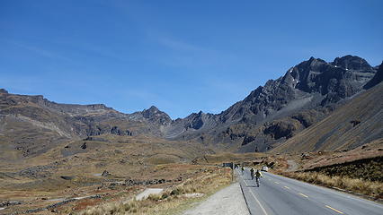
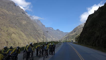
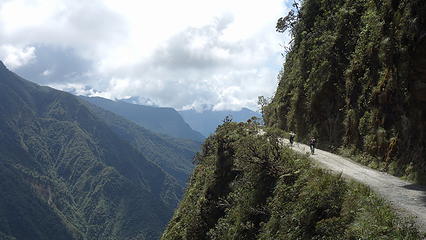
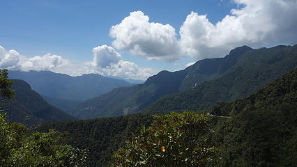
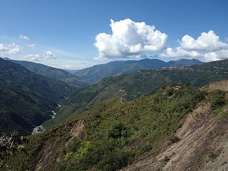
We started the ride on the paved road heading down from the top of the pass under a beautiful clear morning, where we whizzed smoothly down the winding switchbacks as the terrain around us grew higher and higher. After maybe an hour or so, we stopped at a small roadside shack for a snack and we loaded up the bikes for a short stretch of uphill to where the unpaved, official start of the death road broke off to the right from the newer, paved highway. We would soon find out that a rockslide had blocked most of the new paved road further down, which meant that people would be driving on the death road once again (it was officially closed to vehicles when the new alternative route 3 was completed in 2006). But as the Bolivians have always been, they were not afraid to zoom down the death road to avoid a potential traffic jam on the main highway. Their efforts would prove futile however, read on to find out  eek.gif 

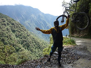
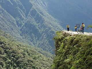
We all saddled up once again and I convinced our guide to give me a bigger bike with full suspension since the one I had was too small. Down we went, and the guides didn't force us to stay together so we were all free to bomb down at our own pace so a few Aussies and I charged out in front, passing other guided groups ahead of us. The famous spot where the road is carved out of an overhanging cliff we all stopped for some photos. By this point it was downright hot out and I removed my pants and shirt, knowing now I definitely could not fall! 

Nearing the top of the pass
Having a great time!
Biking down the paved section of our ride
Our group
Our group
 
Dropping elevation into greener pastures
 
Start of the death road
Biking the death road
Don't fall
Don't fall
 
The famous section of road


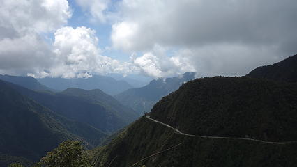
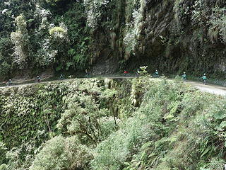
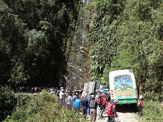
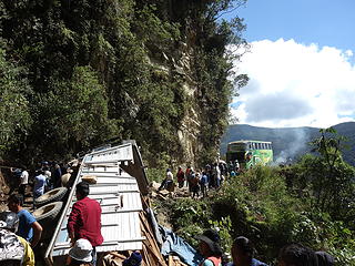
We continued on, and soon came to realize why the road really was the death road. A huge traffic jam was the first thing we noticed, at which point our guides planned to separate, and we would have to leave our support van behind, since it didn't look like vehicles were going to be able to move for a long time. As we biked, weaving through the parked cars and buses we came upon the culprit. A truck carrying a ton of wood had fallen off the road and into the ravine, partially blocking the road. Two large buses going opposite directions were the first vehicles in the lineup going both ways and unable to pass around. It was amazing the truck didn't fall completely over the cliff, and the driver surely was lucky. People with sledgehammers were working tirelessly pounding away at the rock cliffs on the uphill side of the road trying to widen it just enough for the buses to pass by!  eek.gif  shakehead.gif  dizzy.gif 

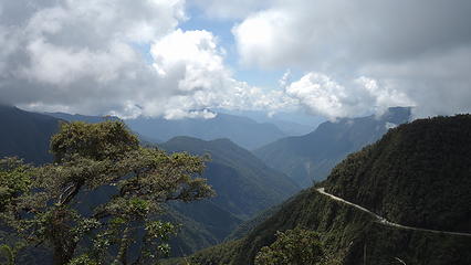
I snapped a few photos and we continued on. We passed by many cyclists, pedestrians (who were in the lineup of cars) and other locals all congregating in the area. After we passed by the lineup of cars going the other way we were smooth cycling again and we continued, the Aussies and I along with a Brit way out in front until we reached a nice shaded cover where many others were resting. The 5 of us or so decided to wait here for the rest of our group since it was getting very hot now. Once our guides eventually arrived with some of our other group members, they went behind a bush and came out with bottles of water! which we were happy to have. The rest of the ride down to the paved Highway 3 was smooth, but since our support vans were still stuck in the traffic jam, we had to ride an additional unplanned 4 flat miles to our final destination. The extra miles were well worth it once we saw where we would have our dinner. 

You can tall it's getting hotter
The traffic jam
The traffic jam
Truck about to go bye bye
 
Our final destination; complete with pool!


We cooled off in the lovely pool and had an awesome buffet style dinner, which alone was worth the $40 they charged for the complete trip. By late afternoon we all piled in the vans (which had eventually arrived) and started the long drive back to La Paz. I returned to the hostel to find Elaine chatting with some other Canadians who randomly came in that day. We then started planning out our logistics for climbing Huayna Potosi, and took the next day to speak with one of the agencies about transportation to Zongo Pass, and buying food. 

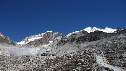
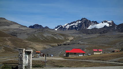
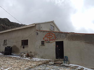
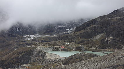
The next morning, we were up early to finish packing up whatever we needed for the next 3 days, and our ride picked us up along with a few others in the van going up for a guided climb. By late morning we arrived at Zongo Pass (elev 4760m), and took a few minutes to check out the hut where all the guided parties stay their first night. It was pretty cool inside actually with lots of climbing photos and articles. I looked around for the rock climbing walls I knew were around, and saw what I thought was a couple of them and noted the climbing looked awesome, however it was too cold and moist to try and pursue anything. We then started walking up the trail towards the high camp. We came up to a local man carrying lumber on his shoulders, walking up the trail in sandals! Holy smokes these people are tough. 

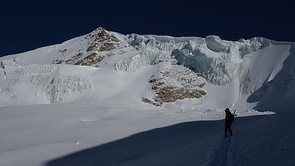
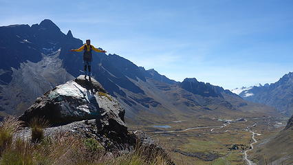
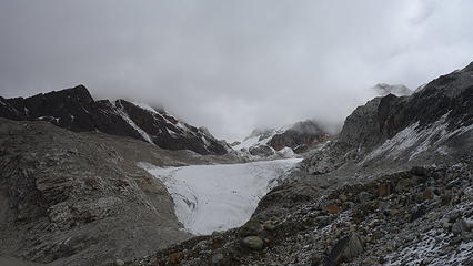
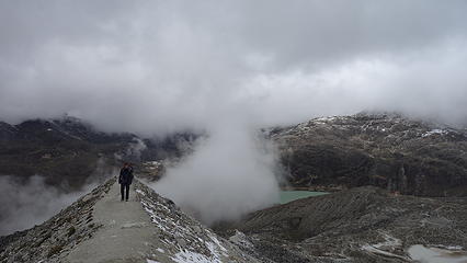
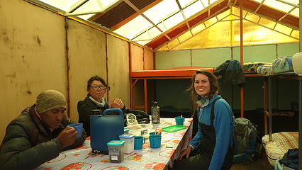
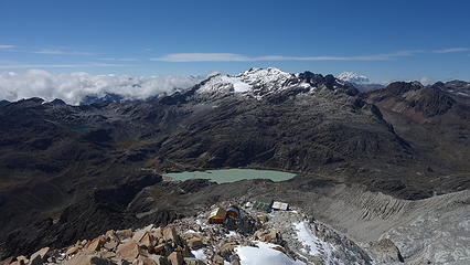
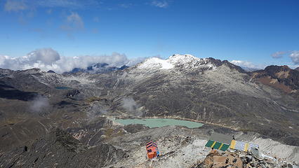
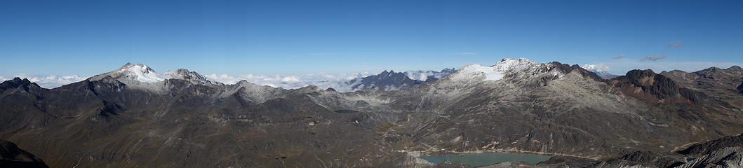
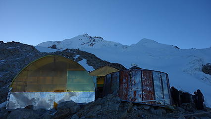
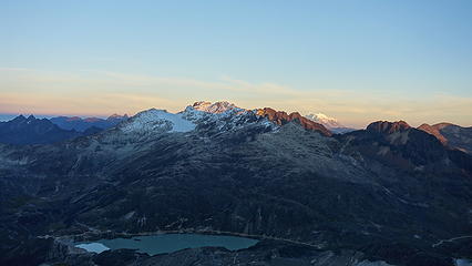
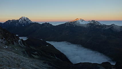
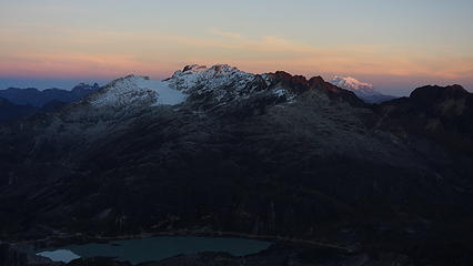
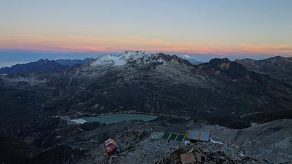
The skies were a bit overcast as we hiked up, and even snowed a little just as we reached the 2/3 point where the fee collector was sitting in a small shack. We paid the nominal $10ish fee to enter the national park and continued up the now steeper trail. We were by this point fairly well acclimated to the 5600-5800 meter elevation range so hiking up to the high camp at 5200 meters was no problem. As we ascended we saw a gorgeous emerald lake below us at the toe of the glacier, and even saw some people practicing ice climbing on the seracs. There are 4 huts in the 5150-5250 meter elevation range on the ridgecrest just as the glacier starts. We chose the 3rd one because the guy carrying the lumber was the owner of that one and invited us to stay. Usually the guided groups pay these hut owners a cut for them and their clients to sleep and have dinner, but the hut owners are also happy to take independent parties. It was a sweet setup he had, a cook house, and a guest house with room to comfortably sleep 16 people. A guided group of 4 came in shortly after we arrived and we chatted with them for a while, which they were even nice enough to share their dinner with us. 

Refugio Casa Blanca at Zongo Pass
Views from the trail
Beautiful lake at toe of glacier
 
Nearing the first hut
 
Remaining route in view from the 3rd hut
Elaine and the other visitors


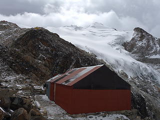
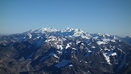
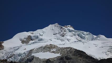
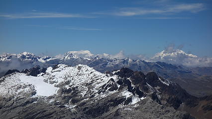
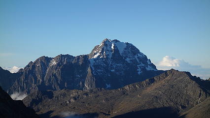
It's worth noting the owner of the hut built the whole thing himself, carrying up all the materials on his back! What a task. Elaine and I discussed our primary route of choice, which was the French Route, which from afar looked like it was in good condition. Since we had came all the way from La Paz to the high camp in one day, and the weather the following day didn't look so good, we decided to take a full rest day at the hut and climb the day after. Our new friends continued on at 2am the next morning while we relaxed and made a short 150 meter ascent up the start of the glacier to try and scout out the best way to cross the glacier to the start of the French Route. I located the best route and started stepping in some tracks for us to get a good heading the following morning in the dark. Our friends returned by early afternoon with success stories which they were very stoked about! The summit ridge apparently was wildly exposed...we were getting excited. They left and started down, but shortly before dinnertime, another group arrived giving us more people to chat with. They wanted to start really early so they set their alarms for 12am, while we agreed the 2am wake up time was sufficient. The sun came out that day on our short hike and we finally saw the entire mountain. The views at sunset were glorious...the next day was going to be awesome! 

Llamp'u (5470m)
Llamp'u (5470m)
Tilata (5310m)
Tilata (5310m)
Huayna Potosi with the French Route directly up the face at center left
Unnamed 5450m peak on south ridge of Huayne Potosi. Notice ski tracks.
Looking up Huayna Potosi
The 4 refugios visible with Chacaltaya (5330m) behind
Bolivians are proud!
 
Illimani at right
Illimani at right
Afternoon contrast on Huayna Potosi
Looking down on the lower huts on the ridge
 
This mountain looks impressive
View of our refugio at dusk
 
Sunset with Illimani at right
Zongo Pass and Chacaltaya at sunset
 
Sunset
Sunset
 
Sunset
Sunset
 
Llamp'u on the left
Llamp'u on the left
Dusk on Huayna Potosi


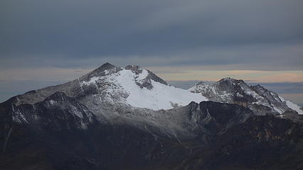
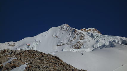
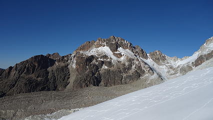
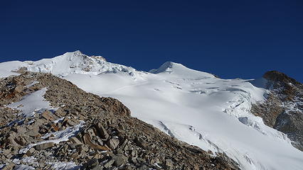
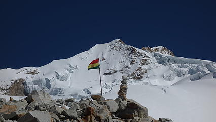
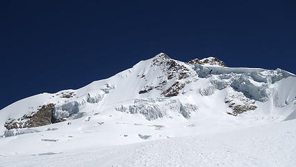
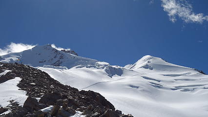
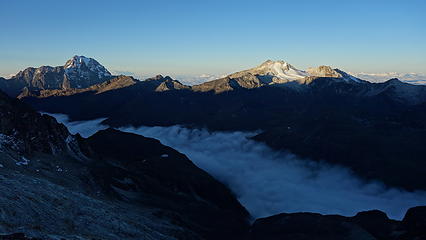
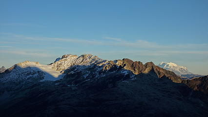
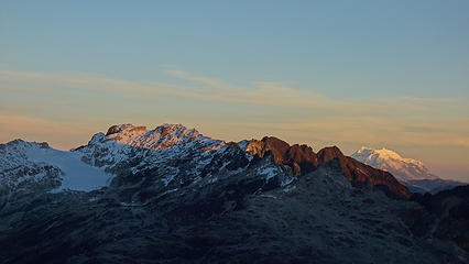
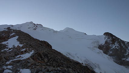
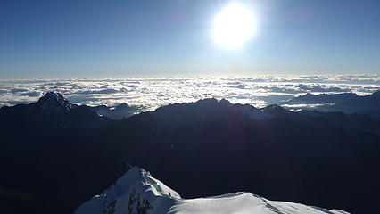
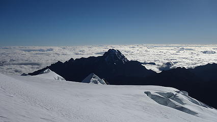
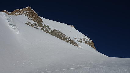
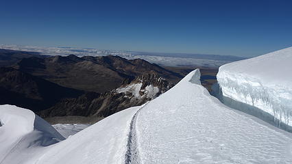
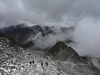
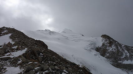
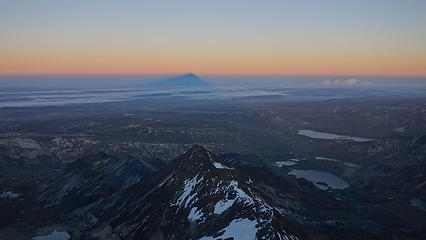
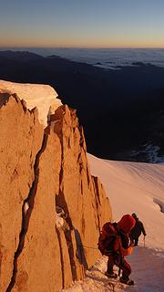
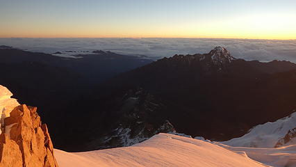
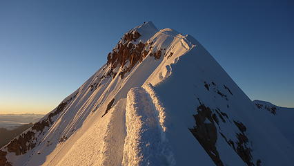
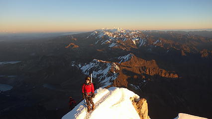
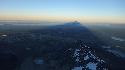
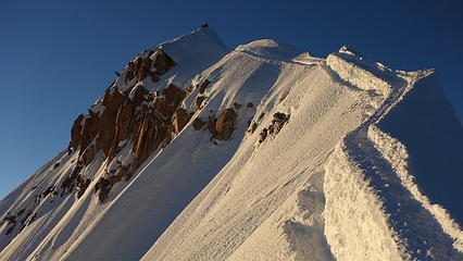
We were one of the last ones to start up the glacier that morning but that didn't matter to us. We started up the same route as everyone else and soon left the hoards of people who seems to multiply out of the other huts! We made a beeline for the base of the French Route, which heads up the direct SE face of the mountain. As we crossed the bergschrund guarding the lower part of the face, we started sinking past our knees in loose powdery snow. This is what I was dreading, and looking up the slope, it didn't appear to get much steeper beyond 50 degrees until much higher so I worried about slogging the whole way up rather than actually climbing up (plus the avalanche danger was much higher if so unconsolidated). We made the unfortunate decision to bail on the route, and cut back over to the standard "trail". By this point everyone else (perhaps 50 people) were on the upper glacier on the west side of the mountain. I led us through a maze of huge crevasses as we veered back over to the normal route, then eventually made it back and ascended up over the ridge again. By this point it was still pitch dark and we were along in our location, which was a little eerie despite knowing ~50 people were a short ways ahead of us. Just as dawn was approaching, we were at 5900 meters with less than 200 to go. We amazingly passed a couple parties on the way up to the final summit ridge which was indeed wildly exposed! It was beautiful actually, however since so many people are on it every day there were two narrow flat paths cut into the otherwise very steep slope leading down both sides. Just a few moments before we took the final steps to the summit the sun rose, lighting up the summit ridge in a beautiful red glow. It was magical, despite having to work around other people going up and down the narrow ridge. 

Huayna Potosi casts a shadow at twilight
Nearing the crest of the summit ridge
 
The money shot! Summit ridge at sunrise
Elaine working through the exposed ridge
Huayna Potosi shadow on El Alto
Cordillera Real Backdrop
Our remaining path to the summit


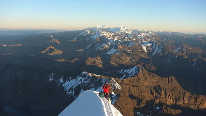
Apparently it's widely common practice for the Bolivian guides that if a client falls off the summit ridge, the guide will jump off the opposite side keeping them both from falling  eek.gif 
As we reached the top, we were at a personal elevation record for both of us at this point, and this was believe it or not my first mountain over 6000m. It was very cold and taking really good photos was tough. We ended up on the summit for just 10 minutes or so before heading back down. We had a relaxing descent back to the hut where our accommodating host was curious about our ascent since not many people likely try for the french direct. After explaining the conditions we saw, he mentioned that the lower third to half of the route is normally unconsolidated, but turns to good ice up higher. Meh, all I could think of was oh well, we still had fun, and made the summit so all was good. We packed up, said our goodbyes and thanked our host. The hike back to Zongo Pass was quick and painless, but unfortunately we had to wait for over an hour for our ride to show up to take us back to La Paz. That night we enjoyed a great meal on the streets, with probably the best tacos I've ever had. 

View east towards the jungle
Endless peaks of the Cordillera Real
Looking down on Llamp'u
Looking back up at the summit on descent
Big crevasses
Big crevasses
 
Hiking out
Hiking out
Huayna Potosi; Definitely a fun peak

Picture
Topo map of the standard route on Huayna Potosi. The hut we stayed at is not marked and between the 2nd and 3rd on the map.
Powered by Create your own unique website with customizable templates.