manakau - 8556' - east ridge class 3
december 2019
With just one week left in New Zealand, weather in the southern Alps was abysmal. Actually, I got word that Lake Wanaka had flooded this past week and closed the Matukituki River Road shutting off all access to Aspiring merely a few days after I climbed it. Parts of the town are also flooding which was caused by a combination of springtime snow melt and heavy rains. A large landslide also covered the road to Tasman Lake, further extending the already long walk into the Plateau hut if one chooses to walk in for Mount Cook, and another landslide blocked the highway towards the west coast over Haast Pass. Weather this week has been very rainy after my successful climb on Aspiring. You could say I got very very lucky to climb these mountains, as some of my friends trying to climb them now are getting shut down.
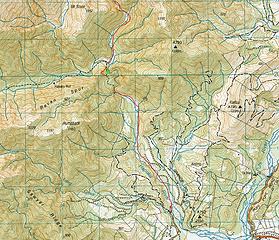
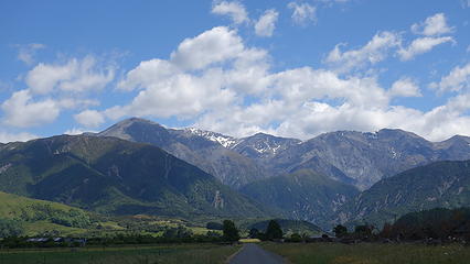
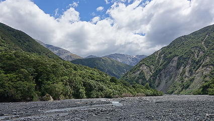
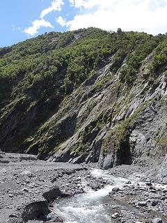
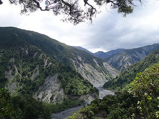
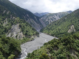
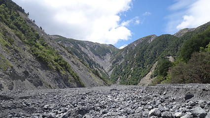
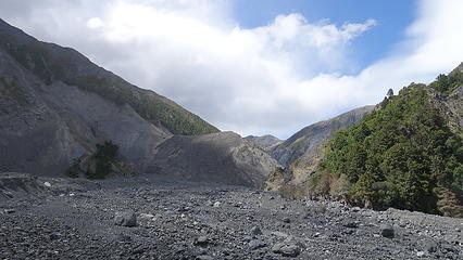
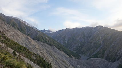
Anyway, to escape the bad weather I drove to the northeast part of the south island, and settled in at Kaikoura for a night, enjoying a lovely beachside hostel and had the local catch of the day for dinner. I had my eyes on Manakau, a 2608 meter high ultra-prominent peak in the Seaward Kaikoura Mountains. Gimpilator has a good page about it on SummitPost, however things have changed dramatically since his visit in March 2016, due to the Kaikoura earthquake that hit on November 14th 2016 which caused 100,000 landslides (yes, you read that right) in the Kaikoura region. One such landslide completely reshaped the Hapuku River valley, forever changing the approach for this mountain. In an event of total biblical proportions, during the earthquake a multi-dozen million cubic meter historic landslide came off the eastern flank of Surveyor Spur (the ridge you ascend on the route up Manakau; more on that further down) and cascaded down the Hapuku River Valley for a full two miles burying the entire valley floor in an average of 10 meters of rubble with some areas getting over 50 feet of coverage. In the process, all trees in the valley were stripped clean down to the roots and the steep valley walls showed clear evidence of getting sliced clear of all vegetation, rocks and hope as the landslide would have scoured down the entire valley. When it was all said and done, the valley was widened due to the massive amount of rubble and nothing more than cobbles, boulders and sand filled the new valley floor which was now raised in elevation 30-50 feet the entire way. At the upper end of the landslide where the slide would have first it the valley floor after falling from the steep flanks, the rubble created a wall across the valley over 300 feet tall creating a new lake. Over the past 2-3 years the water outflow from the new lake forced its way through the wall and cut a path, dividing the rubble exposing near vertical moraine-like cliffs above the stream. The scale of this event is truly astounding, and I will do my best to show it in the photos below.
As another aside, many more landslides covered the highway that runs along the east coast north and south of Kaikoura. The town was completely cut off for quite some time, and rebuilding the road took nearly 2 years to get it reopened for any traffic at all, and work is still ongoing to complete the re-building works over 3 years later. Sections of the beachfront highway for miles were covered in landslide debris that was measured in the hundreds of feet deep!
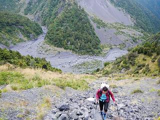
Returning back to my climb, I did not realize any of this until I was midway through the approach up the Hapuku River. I drove to the standard location where people park for hiking up this river valley on Grange Road which it at a measly 100 meters elevation. This would mean the net elevation gain for this climb is 2500 meters plus any ups and downs! I decided to break it into a day and a half, leaving at noon to hike in to Barrats Bivy (which I would find out no longer exists as it was buried in hundreds of feet of debris). Regardless, I started up the wide open lower Hapuku River, crossing to the east side of the stream utilizing large boulders where the road crosses. I was able to easily stay on the streams east side the entire way up to where you start up the bypass trail that heads above and around a section of the valley that narrows into a steep gorge. Since the trail ascends the small ridge on the west side of the valley, I had to ford the stream once immediately before starting up the trail to get back to the west side. A simply knee deep wade was required but this would be the only time I needed to get my feet wet.
Once on the trail, it was easy to follow, however I had to ascend 200 extra feet on a newly built steep trail to bypass another landslide that took out part of the trail that traversed the slope above the gorge. The extra gain added some time but was manageable. I then met up with a large side stream coming in from the west and hiked east down this valley for a few hundred meters before continuing left (northward) up the main Hapuku River. It was when I started this final segment I noticed something very odd. The entire valley floor was devoid of all vegetation and very wide. My suspicions were confirmed when I crossed paths with two local hikers returning from the new lake and they told me about what had happened here, also informing me that Barrats Bivy was destroyed. Not bringing a tent I would have to find a place to bivy, and hope it didn't rain. I continued up the consistent uphill grade constantly boulder hopping, easily crossing the stream on boulders as necessary until the large rightward bend in the valley that Gimpilator mentions in his page at 720 meters of elevation. This bend is where the route up to Stance Saddle (the beginning of Surveyor Spur) starts. I looked around for any kind of natural shelter where I could set up my bivy and in a small patch of trees, found a perfect spot right at the edge of the valley. It took me about 3.5 hours to reach this spot from the car. As I rested and drank some water, I heard small rock and scree slides coming down the steep slopes in the zone the landslide came from. Wind would also whip up rock dust and blow it down valley providing evidence that this whole mountainside was still unstable. I would soon realize that this entire mountain range is falling apart, and the rock comprising it is total garbage!
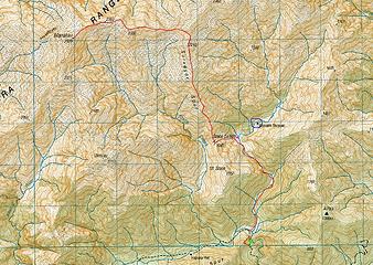
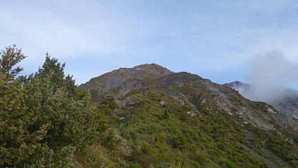
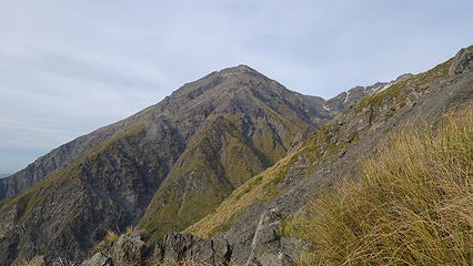
I doctored up my bivy a little bit, and as the afternoon progressed, it looked like I would be spared any rain. The only chance of rain that was forecasted was early in the afternoon, with the following day to be perfect. I ate some veggies and jelly beams for dinner and shortly before sunset drifted asleep under my secluded and protected tree canopy. At 5:30am I emerged and packed up my sleeping gear, and left it on a large rock near my bivy. By 5:45am I started hiking up the slope to Stance Saddle. It was roughly 330 meters ascent to the saddle (elev 1050 meters), which marks the low point on Surveyor Spur. The slope to the saddle was a lot of scree, but I was able to avoid most of the scree by stringing together vegetation zones. Once on the spur, I turned right and followed the faint trail through an initial shrubby section then through tussocks. As I gained elevation, there were huge tension cracks in the ground on the right side of the ridge as I hiked up, and very unstable material on the steep slopes below. This is where the large slide originated below me to the right (east). The soil horizon was clearly being stressed on the crest of the ridge where it hadn't completely fallen down the slope.
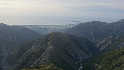
About 400 meters above Stance Saddle, the ridge steepened for a 30 meter section. I decided to climb directly up the steep rock slabs offering some class 4 scrambling to spice things up, however traversing horizontally left here to a short spur rib would bypasses this section keeping it at class 2. Above this the spur was a mix of easy walking and very loose scrambling. Between 1500 and 1900 meters the ridge was annoyingly steep and loose but always manageable. Shortly above 1900 meters it leveled off considerably into a gentle upward walk on fine scree all the way to unnamed Point 2210. Here I had a grand view of Kaikoura and the ocean, as well as a great overlook of the remainder of the east ridge to the summit of Manakau, still nearly 2 miles away. I also had cell service from about 1200 meters elevation and above as there was a clear line of sight to the Kaikoura Peninsula from here on up.
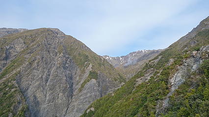

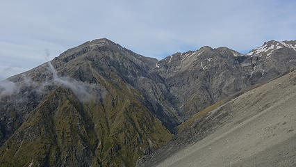
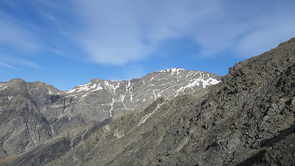
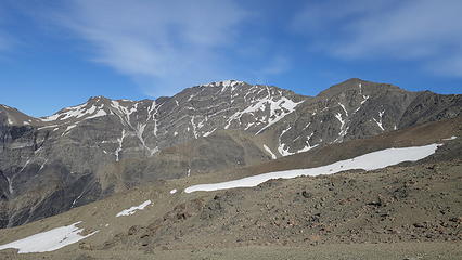
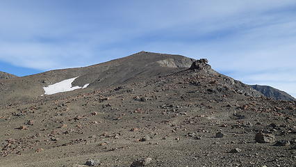
From point 2210, I descended 15-20 meters to the small saddle and started sidehill traversing left towards the low 2110 meter saddle between Manakau and Surveyor Peak, which lied off to the northeast.This traverse was quite loose and full of scree since it was dry. In fact only small very scattered snow patches remained on the entire range which was very little for springtime in New Zealand I thought. When I reached the low saddle, I started hiking the long east ridge of Manakau which was considerable gentler than Surveyor Spur. As a comparison, Surveyor Spur gained nearly 1200 meters in about 2 miles of distance while the upper east ridge only gained 500 meters in the same horizontal distance. There were many small rock spires to traverse through and around but they were all easy to bypass. One large gendarme shortly below the summit was bypassed on the right (north) side with one short class 3 crack scramble, the rest of which was class 2+ on loose scree and talus. At 10:15am I stood on the summit, having gained 2000 meters in 4.5 hours. Not a great pace but acceptable considering I was still a bit tired from Cook and Aspiring. The view off to the west of the Inland Kaikoura Range was also drier than I would have expected. Only small fingers of snow in the most shaded couloirs on the south face of Tapuae-O-Uenuku (the highest peak of the Inland Kaikouras; also an ultra prominent peak) remained. Overall the views were not as inspiring compared to the massive glaciated peaks of the Southern Alps but the elevation gain required for these peaks certainly makes these mountains worthy.
With the wind whipping up a bit, I took a rest on the sheltered south side and refueled my body, drinking water and eating candy. By 11am I started down, and since so much of the terrain was soft scree I was able to make very quick work walking down at times plunge stepping in the scree almost as if it was snow. The worst par of the descent was in the 1900-1500 meter range on Surveyor Spur since there was a solid rock base with loose boulders and cobbles covering it in this zone. It was here to my utter surprise I ran into a couple people heading up! They had camped at the lake the night before which is why I missed them (the lake is a bit beyond the start of the route to Stance Saddle, and I didn't want to backtrack). I was astonished to find someone else crazy enough to go up this crumbling pile of sh## midweek haha. We briefly chatted and I provided them with some useful route beta and I continued down. By 2pm I was back at my bivy and packed up my sleeping gear and wasted no time starting the hike out. It was an uneventful return to the car which I reached at 5pm.
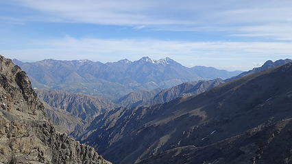

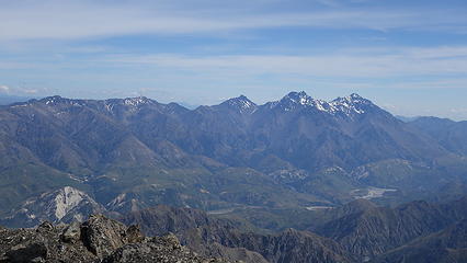
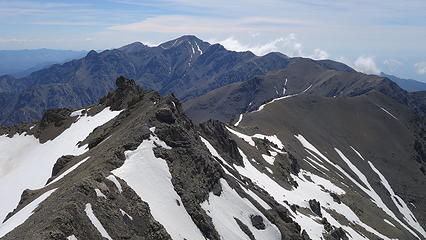
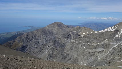
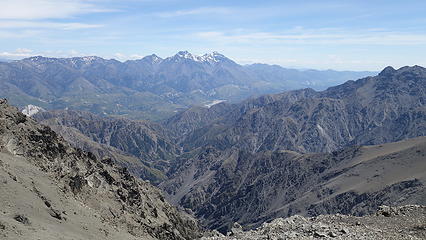
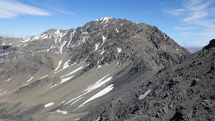
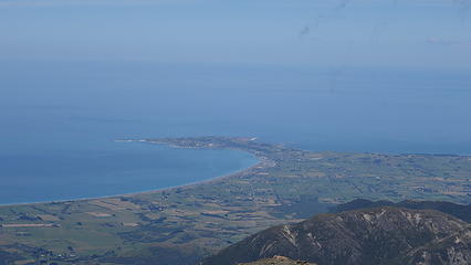
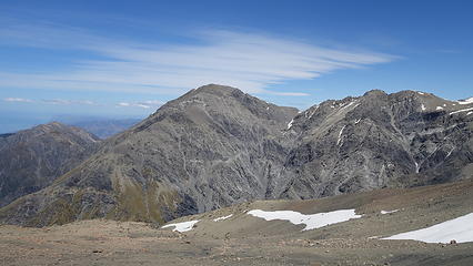
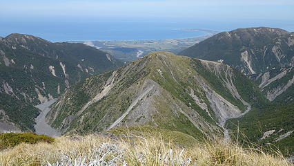
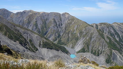

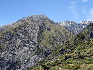
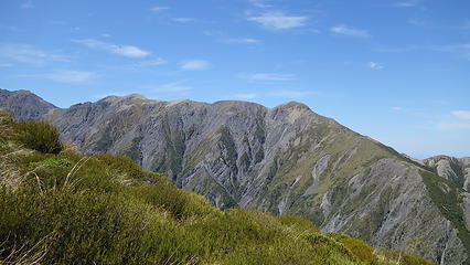
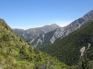
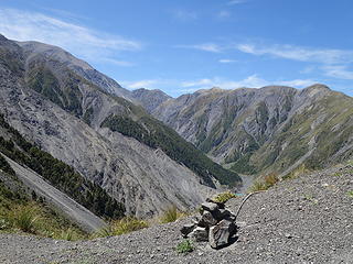
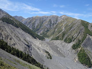

Photo Comparison
The below photos show the upper Hapuku Valley taken from the slopes below Stance Saddle. The first one is taken by Gimpilator in March 2016 before the earthquake and the second one was taken by myself just a few days ago. The difference is mind-blowing.
For more information and photos of the landslide check out this page