LEMKE CLIMBS
  • About
    • Whats New
    • 2019 Goals/Wishlist
    • Contact
  • Washington
    • North Cascades >
      • Sahale Peak, Boston Peak
      • Eldorado Peak, Klawatti Peak
      • Black Peak
      • Forbidden Peak West Ridge
      • Primus Peak Attempt
      • Big Snagtooth
      • Liberty Bell Beckey Route
      • Burgundy Spire North Face 5.8
      • Ragged Ridge - Katsuk, Kimtah and Cosho Peaks
      • Colfax Peak
      • South Early Winters Spire via SW Buttress
      • Chilliwack Mini-Slam
      • Mesahchie Peak
      • Inspiration Traverse
      • Mount Shuksan Ski
      • Full Pickets Traverse
      • Mount Goode NE Buttress & Storm King
      • Mount Baker North Ridge WI3
      • Snowfield Peak
      • Lincoln Peak
      • Silver Star Mountain
      • Mount Buckner & Horseshoe Peak
      • Azurite Peak
      • Tower Mountain & Golden Horn
      • Mount Logan
      • Custer Ridge & Easy Mox
      • Mazama Dome
      • Sherman Peak
      • Mount Ballard
      • Southern Pickets Traverse
      • Corteo Peak
      • Whatcom Peak
    • Glacier Peak Wilderness >
      • Buck Creek Pass, Cloudy Peak, Spider Gap
      • Dome Peak, Spire Point
      • Mt. Maude and Seven Fingered Jack
      • Mount Formidable NE Face 5.6 Second Ascent
      • Dumbell and Greenwood Mountains
      • Glacier Peak Wilderness Mountain Massacre
      • Clark and Luahna Peaks
      • Sinister Peak
      • Chiwawa Mountain
      • Tupshin & Devore Peaks
      • Buck & Fortress Mountains
      • Glacier Peak
      • Snowking Mountain
    • Olympic Peninsula >
      • Buckhorn Mountain
      • Flapjack Lakes Hike
      • Grey Wolf Peak, High Divide Trail
      • Mount Ellinor
      • Mount Constance West Arete
      • Mount Olympus
    • Alpine Lakes Wilderness >
      • Chikamin Peak
      • PCT - Snoqualmie to Pete Lake
      • Foss Lakes Hike
      • Necklace and Tank Lakes
      • Enchantments Day Hike
      • Granite Mountain (Snoqualmie)
      • Colchuck Peak
      • Cannon, Enchantment and Stuart
      • Ingalls Peaks
      • McClellan Peak
      • Dragontail Peak
      • Web Mountain
      • Mount Index Attempt
      • Snow Creek Wall Orbit 5.8+
      • The Tooth South Face
      • Eightmile Mountain
      • Argonaut Peak NE Couloir
      • Little Annapurna South Face 5.5
      • Snow Creek Wall Outer Space 5.9
      • Cashmere Mountain
      • Sherpa Peak North Ridge 5.8
      • Chair Peak NE Ridge
      • Lichtenburg Mountain
      • Mount Index
      • McClellan Butte
      • Chimney Rock
      • Alpine Lakes High Route
    • Pasayten Wilderness >
      • The Craggies
      • Tiffany Mountain
      • Pasayten Mini-Slam
      • Remmel Group
      • Jack Mountain
      • Robinson Mountain
      • Monument Peak Group
    • Mountain Loop Highway >
      • Vesper Peak
      • Mount Dickerman
      • Sloan Peak West Face 5.8
      • Mount Forgotten
      • Whitehorse Mountain
      • Gothic Peak
    • Lake Chelan Sawtooth Wilderness >
      • Star, Courtney, and Grey Peaks
      • Hoodoo Peak and Raven Ridge
      • Abernathy Peak
      • Mount Bigelow
      • Reynolds Peak
      • Oval Peak
      • Gardner Peaks
      • Chelan Sawtooth Trio
    • Southern WA >
      • Mount Adams
      • Mount Rainier - Emmons Route
      • Mount Saint Helens
      • Goat Peak
      • Lane Peak, Plummer Peak (Tatoosh)
      • The Unicorn (Tatoosh)
      • Little Tahoma
      • Liberty Cap
    • WA Rock and Ice Cragging >
      • Index Town Walls
      • Vantage
      • Mount Erie
      • Exit 38
      • Leavenworth
  • Colorado
    • San Juan Mountains >
      • Mount Sneffels Lavender Snow Climb
      • Uncompahgre, Matterhorn Peaks
      • Redcloud, Sunshine Peaks
      • San Luis Peak
      • Vermilion, Fuller Peaks
      • Stewart Peak, Baldy Alto
      • Jones, Niagara, American Peaks
      • Wetterhorn Peak, Handies Peak
      • Wilson Group
      • Arrow Peak
      • Mount Sneffels SW Ridge
      • Jagged Mountain, Chicago Basin
      • Teakettle Mountain
      • Dallas Peak
      • Vestal Peak Wham Ridge, Greystone Peak
      • Organ Mountain
      • Phoenix Peak
      • Half Peak
      • Point 13832 Group
      • Golden Horn
      • Mount Sneffels Snake Couloir
      • Pigeon, Turret Peaks
    • Elk Mountains >
      • Four Pass Loop
      • Castle, Conundrum Peaks
      • Snowmass Mountain
      • Cathedral Peak
      • South Maroon Peak
      • The Pyramids
      • North Maroon Peak, Sleeping Sexton
      • Capitol Peak, Mount Daly
      • Malemute Peak
      • Hagerman Peak
    • Sangre de Cristo Mountains >
      • Blanca Peak, Ellingwood Point
      • Challenger Point
      • Mount Adams
      • Spread Eagle Peak
      • Humboldt, Obstruction, Columbia Peaks
      • Mount Lindsey, Huerfano Peak
      • Little Bear Peak
      • Crestone Needle Ellingwood Arete
      • California Peak
      • Crestone Peak North Buttress
      • Operation Dark Snake
      • Kit Carson Mountain
    • Sawatch Mountains >
      • Iowa Peak
      • Point 13,618 - Hunky Dory Lake
      • Gold Dust Peak, Notch Mountain
      • Mount Jackson
      • Mount Belford
      • Shavano, Tabeguache Peaks
      • Mount Antero, Cronin Peak
      • Twining Peak
      • Mount Massive
      • Casco Peak
      • Mount Huron
      • Mount Elbert
      • Mount Oxford
      • Mount Hope
      • Mount Yale
      • Lackawanna Peak
      • Mount Columbia
      • La Plata Peak
      • Rinker and Twin Peaks
      • Bull Hill, Mount Princeton
      • Missouri Mountain
      • Mount Oklahoma
      • French Mountain
      • Mount Ouray
      • Grizzly A, Garfield Peaks
      • Mount Harvard
      • The Three Apostles
      • Emerald Peak
      • Holy Cross
      • Mount Aetna
    • Greater Park Range >
      • Kneeknocker Pass, Piney Lake
      • Drift Peak
      • Sherman Peak, Dyer Peak
      • Gore Range Traverse
      • Quandary Peak
      • Pacific, Atlantic Peaks
      • Clark Peak
      • Crystal Peak, Peak 10
      • Fletcher Mountain
      • The DeCaLiBron
      • Loveland Mountain
      • The Mosquito Traverse
      • Mount Arkansas
      • Clinton Group
      • Eagles Nest, Peak C
      • North Star Mountain
      • Peak X
      • Wheeler Mountain
    • Front Range >
      • Mount Evans, Spalding
      • Mount Bierstadt
      • Mount Parnassus, Bard Peak
      • Cupid, Sniktau, Grizzly D Peaks
      • James Peak
      • Mount Silverheels
      • Grays and Torreys Peaks
      • Mount Edwards
      • Mount Flora, Longs Peak
      • Square Top Mountain
      • Petit Grepon South Face 5.8
      • Mount Meeker Dreamweaver Couloir
      • Santa Fe Peak
      • The Citadel & Pettingell
    • Colorado Ice Climbing >
      • Lincoln Ice Falls
      • Ouray Ice Park
      • Avocado Gully and The Drool
      • Hidden Falls
    • Colorado Rock Climbing >
      • Eldorado Canyon
      • The Flatirons
      • North Table Mountain
      • Shelf Road
      • Colorado National Monument >
        • Independence Monument
  • Wyoming
    • Wind River Mountains >
      • Gone With the Winds
      • Union Peak - Solar Eclipse
      • Wind River Peak
      • Wind River Slam
    • Teton Range >
      • Grand Teton Owen Spalding 5.4
      • Mount Owen Attempt
    • Wyoming Absarokas and Gros Ventre Range >
      • Jackson Peak
      • Francs Peak
    • Yellowstone National Park >
      • Top Notch Peak
    • Bighorn Range and Great Divide Basin >
      • Boars Tusk
      • Loaf Mountain
      • Cloud Peak
      • Black Tooth Mountain
    • Devils Tower
    • Cody Rock and Ice Climbing
  • Montana
    • Beartooth Mountains >
      • Whitetail Peak Group
      • Beartooth Mountain
      • Spirit Mountain Group
      • Mount Peal
      • Granite Peak Group
      • Castle Rock Group
      • Castle Mountain NE Couloir
      • Mount Inabnit and Sylvan Peak
      • Mount Hague South Slopes
      • Mount Villard and The Granite Peaks Traverse - 5.4
      • Spirit Mountain NE Ridge - 5.4
      • California Ice WI 4
      • The Ramp 5.8
      • Linea Alba 5.10d
      • Iceberg Peak
      • Metcalf Mountain North Rib 5.8
      • Villard Spires HP West Ramp
      • Cairn Mountain
      • Snowbank Mountain
      • Mount Wood Group
      • Bears Tooth
      • Glacier Peak Catch-a-Sunrise FA
    • Montana Absarokas & Gallatin Range >
      • Black Mountain
    • Southwest Montana Ranges >
      • Sacajawea Peak
      • Arrow Peak
      • Koch Peak
      • Saddle Peak
      • Baldy Mountain
      • Sphinx Mountain
    • Glacier National Park >
      • A Taste of Glacier National Park
      • Divide Mountain
    • MT Rock and Ice Climbing
  • Utah
    • Uinta Mountains >
      • Kings-Emmons Ridge Run
      • Hayden Peak
      • Iron Hayden Wall Rock Climbing
    • Wasatch Range >
      • The Sundial Eleventh Hour 5.8
      • Mount Timpanogos
    • San Rafael Swell >
      • Ramp, Cistern Canyons
      • Salt Wash, Black Mountain, Moroni Slopes
      • Ding, Dang Canyons
      • Little Wild Horse, Bell Canyons
      • Quandary Canyon
      • San Rafael Knob
      • Miners Hollow (Knotted Rope Canyon)
      • Temple Mountain
      • Chimney Rock
      • Bottleneck Mesa
      • Window Blind Peak
      • Lower Baptist Draw & Upper Chute Canyon
    • Capitol Reef National Park >
      • Cathedral Valley Tour
      • Sheets Gulch
      • Halls Creek Narrows
      • Brimhall Canyon and Strike Valley Overlook
      • George Benchmark
    • Moab Area, Canyonlands, Arches >
      • Maze District
      • Needles District
      • Maze District
      • White Rim Trail Biking
      • Elephant Butte, Bullwinkle Tower and Lizard Rock
      • South Six Shooter
      • Elephant Canyon
      • Parriott Mesa
      • Ancient Art
      • Castleton Tower North Chimney 5.8
      • Klondike Bluffs
      • Mount Peale & Tukuhnikivatz
    • Robbers Roost Country >
      • Horseshoe Canyon, Goblin Valley
      • Bluejohn Canyon
      • Happy Canyon Narrows
      • Shenanigans, Leprechaun Slots
      • Larry Canyon
      • Merry Piglet Slot
      • Lower Maidenwater Canyon, Turkey Knob
      • Morocco Canyon
      • Monkey Business Slot
      • Hog Canyon Slots
      • Upper Maidenwater Canyon Slots
      • Mount Ellen
      • Buck Canyon
      • Point 4906
      • Alcatraz Canyon
      • Hard Day Harvey Slot
      • Mount Ellsworth
      • Good Day Jim Canyon
      • White Roost Canyon
      • Upper Stair Canyon
      • Dragon Canyon
    • Escalante National Monument >
      • Phipps Canyon and Arch
      • Red Breaks Slot
      • Dry Fork Slots, Coyote Gulch
      • Little Death Hollow/Wolverine Canyons
      • Egypt 3 Slot
      • Egypt 1 Canyon
    • Zion/Bryce >
      • Ataxia Tower Ashtar Command 5.9
      • Mount Kinesava Cowboy Ridge
      • Birch Hollow
      • Aires Butte
      • West Temple
      • Mystery Canyon
      • Crazy Streak
    • Cedar Mesa Region/Valley of the Gods >
      • Eagle Plume Tower Eagle Feather 5.10b
  • California
    • High Sierras, Southern CA Ranges >
      • Telescope Peak, Manly Beacon
      • Tahquitz Rock Whodunit 5.9
      • Tahquitz Rock Long Route 5.9
      • Palisade Traverse
      • White Mountain
    • Yosemite National Park, Central CA
    • Northern CA Cascades >
      • Lava Beds National Monument
      • Mount Shasta
  • Oregon
    • Oregon Volcanoes >
      • Three Fingered Jack
      • Mount Scott
    • Blue Mountains >
      • Twin Peaks
    • Trout Creek Rock Climbing
  • Alaska
    • Eagle Peak and Mount Ewe
    • Jatt Peak and Portage Pass
    • Rainbow Peak
    • Mount Brooks Attempt
    • Arrigetch Peaks Trek
    • Ab Mountain Hike
    • South Suicide Peak
    • Mount Hunter West Ridge Attempt
    • Cantata Peak Attempt
    • East Twin Peak
    • Mount Alice
    • Crow Pass and Hope Point Hikes
    • Indianhouse Mountain Attempt
    • Lynx Peak
    • Harding Icefield Hike
    • Hatcher Pass and Grapefruit Rocks Climbing
    • Mount Sanford
    • Mount Hunter West Ridge
  • Nevada
    • Ginger Cracks 5.8
    • Mescalito Dark Shadows 5.8
    • Birdland and Olive Oil
    • Frogland 5.8
    • Johnny Vegas 5.8
    • Schaeffer's Delight & Triassic Sands
    • Solar Slab - 5.6
  • British Columbia
    • Mount Matier
    • Taiya Peak
    • Bugaboo Spire NE Ridge
    • Mount Sabine Easy Honey 5.10b
    • Mount Sir Donald NW Ridge Attempt
    • Black Tusk
    • Squamish Ticks
    • Slesse Mountain NE Buttress
    • Warden Peak
    • Triple Peak
  • Alberta
    • Mist Ridge Hike
    • Mount Temple Attempt
    • East Wendell Peak
    • Loder Peak
    • Tower Mountain Attempt
    • The Rimwall
    • Mount Yamnuska Directissima 5.9
    • Mount Lawrence Grassi
    • Mount Lorette
    • Roche A Perdrix
    • Mount Edith Cavell East Ridge 5.3
    • Mount Louis Kain Route
    • Eiffel Peak
    • Canadian Rockies Ice Climbing
  • Other States
    • Arizona >
      • Grand Canyon Bright Angel Trail
      • Beanfest at Cochise Stronghold
      • Baboquivari Peak
      • Humphreys Peak
    • New Mexico >
      • Philmont Trek August 2008
    • Yukon >
      • Canyon Peak
  • International
    • Mexico & Central America >
      • Mexico - Pico de Orizaba, Izta
      • Guatemala Volcanoes
    • South America >
      • An Introduction to Patagonia
      • Cordillera Blanca - Tocllaraju and Urus
      • Nahuel Huapi National Park & The Frey
      • Exploring Pucon and Lanin Volcano
      • Cordillera Blanca - Ishinca Peak and Artesonraju
      • Cordillera Blanca - Quitaraju & Alpamayo
      • Exploring Southern Peru
      • Cerro Helio Azul & Tronador Attempt
      • Aguja Guillaumet Amy Couloir
      • Cerro Puntado & Palo
      • Cerro Colorado
      • Cerro Puno & Agudo
      • Cerro Trinidad Attempt
      • Volcan Quetrupillan
      • Cerro Placas
      • Nevado de Acay
      • Pequeno Alpamayo
      • Huayna Potosi
      • Illimani
      • Chiaro de Luna
      • Cerro Barros Arana
    • Oceania >
      • Exploring New Zealand's South Island
      • Puncak Jaya
      • Mount McPherson and Talbot
      • Single Cone
      • Mount Cook
      • Mount Aspiring
      • Manakau
    • Central Asia >
      • Kyrgyzstan 2021
  • Sorted by Year
    • 2008 Trip Reports
    • 2009 Trip Reports
    • 2010 Trip Reports
    • 2011 Trip Reports
    • 2012 Trip Reports
    • 2013 Trip Reports
    • 2014 Trip Reports
    • 2015 Trip Reports
    • 2016 Trip Reports
    • 2017 Trip Reports
    • 2018 Trip Reports
    • 2019 Trip Reports
    • 2020 Trip Reports
    • 2021 Trip Reports
    • 2022 Trip Reports
  • Vanlife
    • Conversion Journal >
      • Floor Installation
      • Folding Bed
      • Coffee Table
      • Thinsulate Installation
      • The Couch
      • The Wardrobe
      • Bookshelf
      • Water System
      • Electrical System
      • The Pantry
      • Refrigerator
      • Tire Upgrade
      • Heating System
      • Composting Toilet
LEMKE CLIMBS

Jatt Peak & portage pass

jatt peak - 3352' - nw ridge class 3
​june 2015
See my "Jatt" Peak page on SP

This portion of our Alaska Trip in 2015 was probably my favorite. In short, Jayme and I got a ride to Whittier from Anchorage, and went through the really cool Whittier Tunnel. We did a short day hike up to Portage Pass and saw a complete weather transformation from calm and sunny to cloudy and windy. That next morning, we rented a sea kayak and took a water taxi out to Blackstone Bay and explored the glaciers, and ascended a peak I spotted from the water that appeared to have less buswhacking. Well after the trip I got a message from Steve Gruhn, a member of the Alaska Mountaineers Club who informed me the peak we climbed (which we named Jatt Peak) was probably a first ascent. We then made the 20 mile kayak back to Whittier over a two day period, stopping in Shotgun Cove for the night. See photos of Portage Pass and the route beta and trip report for Jatt Peak below.

Portage Pass Photos


Jatt Peak Description

Overview

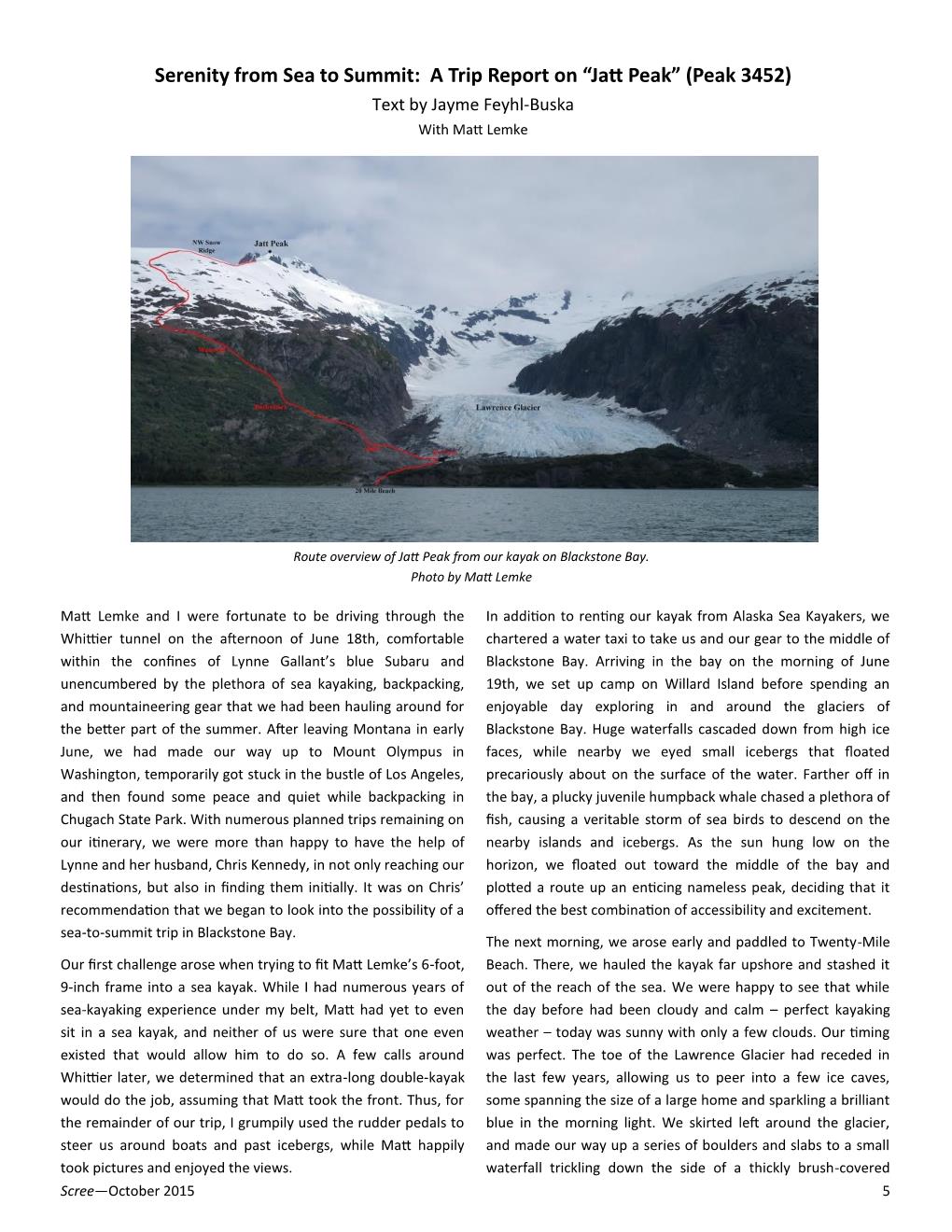
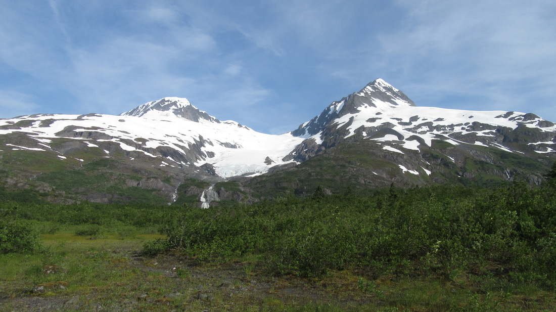
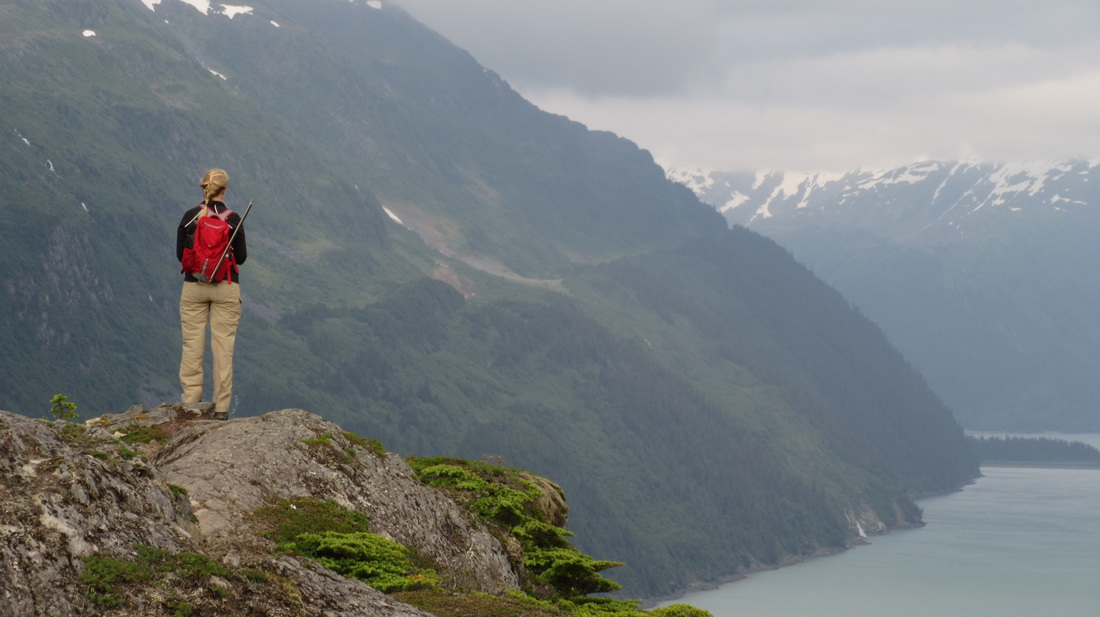
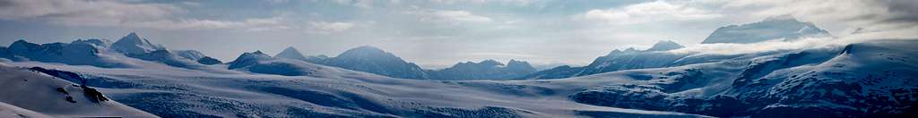
"Jatt Peak" is the name that we (Jayme and I) have dubbed for the unnamed peak about 3 miles east of the head of Blackstone Bay, where the Beloit Glacier dumps into the bay. Located in the southern Alaska coast range just north of Kenai Fjords National Park, and close to Whittier Alaska, this peak, along with the entire surrounding area receives copious amounts of snow. As a result, gigantic ice-fields and glaciers can be seen in every direction from Blackstone Bay and if you're standing on the summit of this peak, glacial ice will dominate the horizon everywhere. "Jatt Peak" rises 502 from its key saddle just to the north which has an elevation around 2,900 feet. It's parent peak is located about 1.5 miles to the NNE, which is another unnamed peak, but was unofficially named Mount Applegate in 1914 and has an elevation of about 3,650 feet. Traversing to this peak from Jatt Peak looked possible but the final 150 feet or so looked technical.

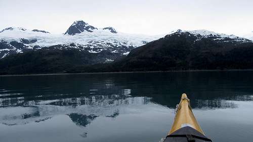
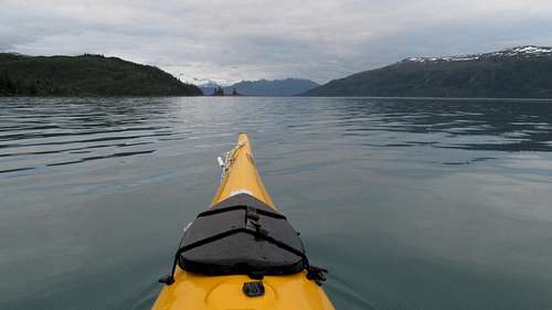
The unique thing about Jatt Peak, as well as any of the other nearby unnamed peaks, is that you need to either kayak, or take a boat to the "trailhead" which is a beach along the eastern shore of Blackstone Bay. In calm waters, it is a fairly long day of kayaking from Whittier (about 20 miles) or you can take a water taxi ride to 20 mile beach which will cost anywhere between $50-200 per person depending on how many people you share the ride with. There are a handful of companies in Whittier with water taxi service and they will also haul your kayak if needed. Think of the route to 20 mile beach as your approach; if you pay for the water taxi, it's the same as paying pack mules to haul you and your gear to the base of the mountain you wish to climb! One way to do it is to take the water taxi with your kayak out, then kayak back, or vice versa.

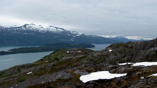
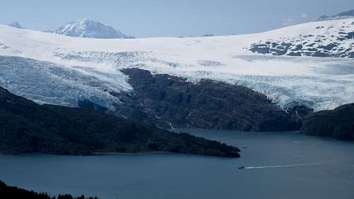
As stated, 20 mile beach is the start of the route up this remote peak (see map below). The route to the summit involves rock scrambling, lots of bushwhacking, and extensive hiking on snow. If you stay on route, you won't have to navigate any crazy glaciers since the route follows a high ridge separating two huge glaciers. There is however a good chance that crevasses are present and knowledge of glacier travel and identifying crevasses is strongly recommended. The views from the summit give perspective on what Alaska emulates. You realize it took you at least 5 hours to ascend a tiny nubbin of a peak and you are surrounded by hundreds of other peaks easily 10 times more remote/difficult. Many of the peaks you see from this summit are unnamed and typically require a plane to even get within a reasonable distance from. Enjoy the time you are up there, and realize that although you may be on one of the easiest and most accessible peaks in the area, virtually no one goes up there, and you won't even see that many people in Blackstone Bay. The people you do see will almost certainly be on a tour boat and paid large sums of money to briefly get a chance to see this beautiful place.

My recommendation? Split the $300 cost with your partner and rent a double kayak from Alaska Sea Kayakers for 5 days and kayak out to 20 mile beach. Camp along the beach as there are many great places to pitch your tent plus you don't actually have to carry it (the kayak holds plenty of gear). Ascend the peak, or explore other peaks, then be sure to kayak to the head of the bay where huge glacial ice walls constantly calve off into the head of the bay. Then kayak back to Whittier. This way you spend $150/person and truly explore the area. People on the tour boats get about 20 minutes to see only the head of the bay and pay upwards of $400/person!!

 
Panorama from the route up Jatt Peak

Getting There

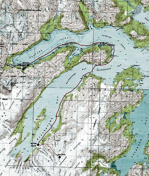
From Whittier Alaska, with your own sea kayak, or one you rent from Alaska Sea Kayakers (I highly recommend them), or utilizing a water taxi ride from theLazy Otter, kayak to 20 mile beach (most of a day in calm water) or ride, which takes roughly an hour. This beach is on the east side of the bay not far from the head. Be extra careful kayaking down the Passage Canal and stay close to the southern shore to be out of the way of the many boats, some of them cruise ships, that will chop up the water and potentially swamp you. Entering Shotgun Cove a little bit will provide you calmer water. Once you round Decision Point, cross Blackstone Bay where the crossing is the shortest. Boat traffic in Blackstone Bay is considerably less. Ideally, try to kayak on a cloudy day since the winds will be low, and the water calm, then do the climb on a sunny day. If you are kayaking on a sunny, windy day, plan on making 2-3 times the effort and time required to get to 20 mile beach, possibly more. Also at least have a general knowledge on what to do if you do flip the kayak. If you aren't wearing neoprene you will need to get to shore ASAP, so it's best to stay close to the shoreline while kayaking.

Calm waters in Blackstone Bay
Calm waters in Blackstone Bay with Jatt Peak on the right
Kayaking back to Willard Island
Kayaking near Willard Island
Resting on a beach with a 4,000 foot peak behind
Resting on a beach

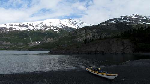
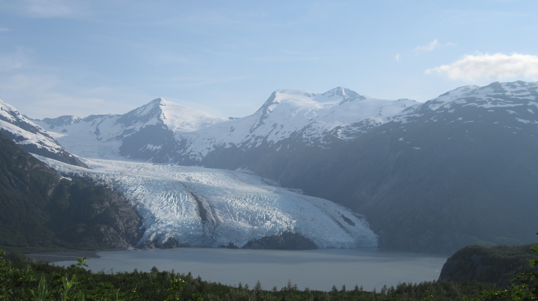
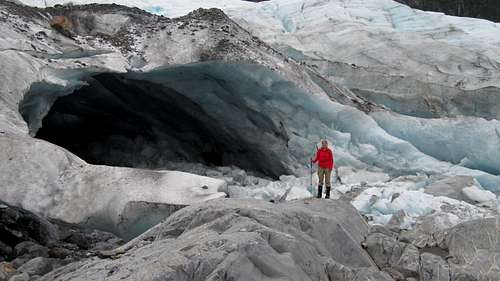
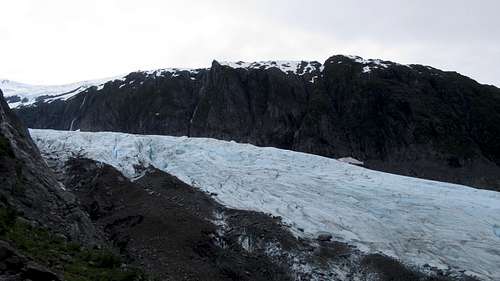
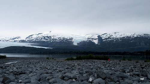
Set up your camp somewhere on the beach above the high tide line and spend a little while exploring the beach, and nearby fresh water ponds. A short 15 minute hike up the stream will take you to the tow of the Lawrence Glacier with a gigantic ice cave big enough to fit a house in! Hiking to the ice cave is also the start of the route so it's worth exploring. It's advised you get an early start as the climb will take most of the day, and try to go on a day it isn't raining...which may not be possible but the weather can be nice sometimes! See the map below for the best kayaking route from Whittier to 20 mile beach.

 
Blackstone Bay and Jatt Peak Topo Map

Route

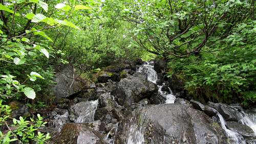
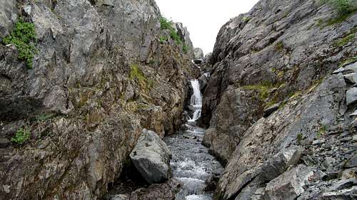
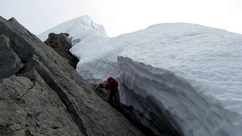
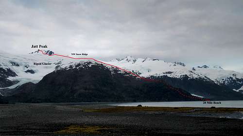
From camp on the beach, hike southeast up the river coming down from the Lawrence Glacier for just a few hundred yards to the huge ice cave, which is a couple hundred feet above sea level and at the toe of the glacier. A few cairns mark the path and some easy scrambling is required. From the ice cave, turn left and begin scrambling northeast up the slabs and aim for the big waterfall coming down the west facing cliffs above you. At about 500 feet above sea level, you will be forced to bushwhack, however if you sneak your way up one of the streams, you can utilize rocky terrain and stay under the worst of the bushes. Don't stray too far left. Once you get to the base of the west facing cliffs, look north and you will see another waterfall coming down from a deep gully. Scramble 100 feet up steep grassy slopes and slabs to the right of this waterfall and emerge into this 20 foot deep gully at the top of the waterfall. Find the easiest route out of this gully up to the right. This will likely be the crux of the route and will require some exposed Class 3 scrambling on potentially wet slabs. Find a spot that isn't as steep and utilizes a good tree near the top.

The ice came at the toe of the unnamed glacier west of Jatt Peak
The ice cave at the toe of the Lawrence Glacier

Jayme looks in the distance over Blackstone Bay
Looking down at 20 mile beach
Bushwhacking to the NW ridge of Jatt Peak

Ascending Jatt Peak
Lawrence Glacier from the waterfall
Deep chimney waterfall near treeline
Deep chimney above the waterfall. Climb out to the right

Hiking to the long ridge on Jatt Peak
Working up to the long ridge on Jatt Peak

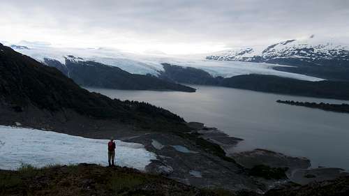
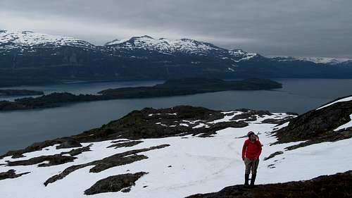
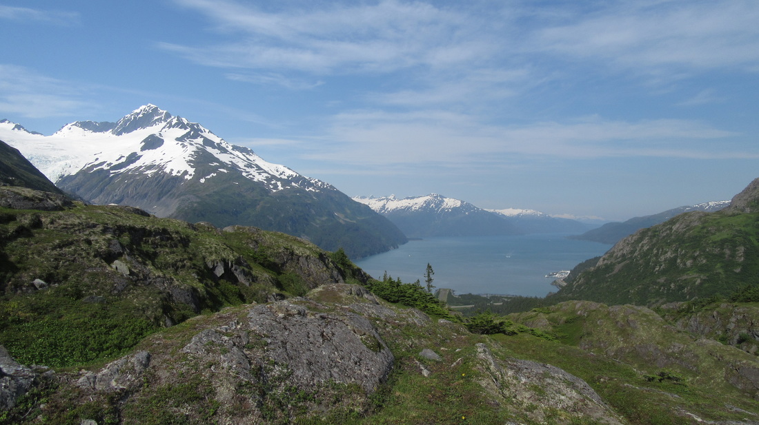
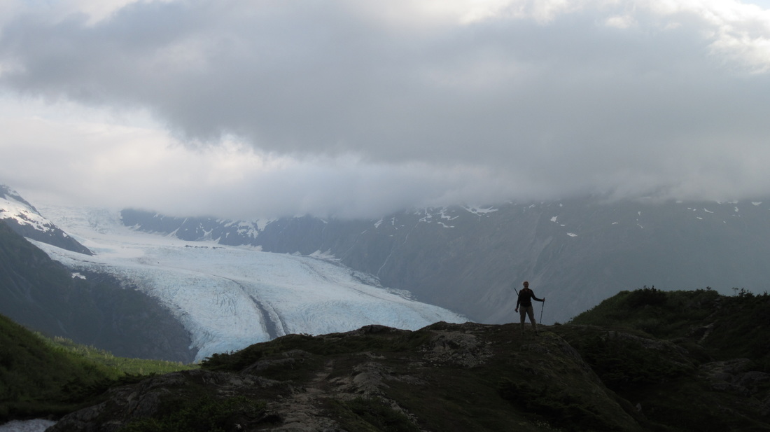
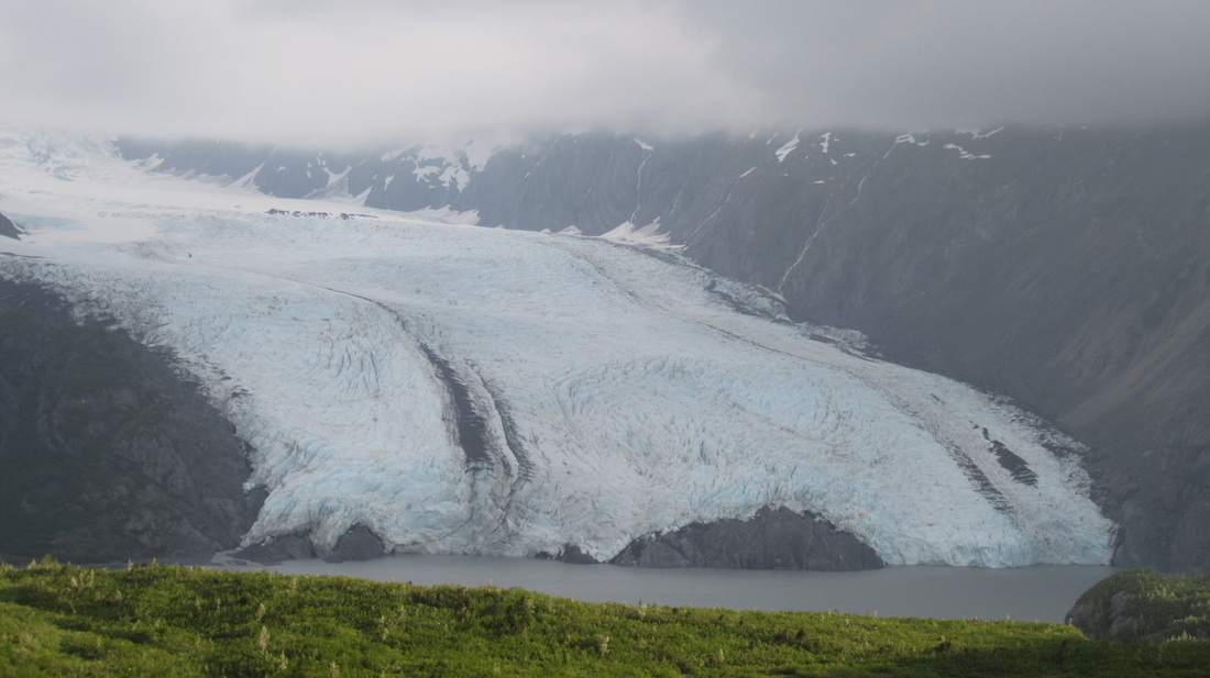
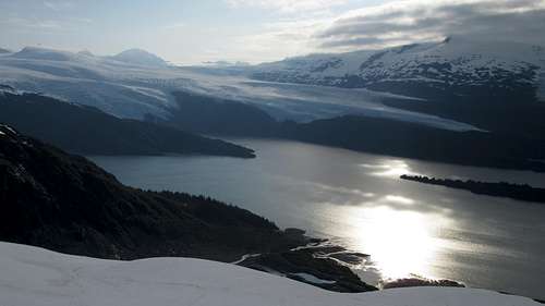
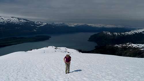
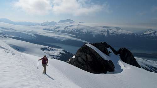
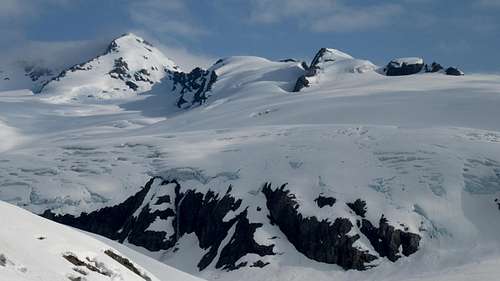
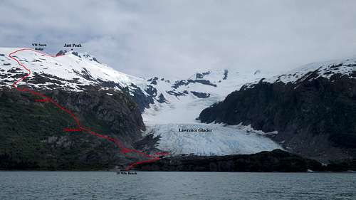
Once out, you will be at roughly 900 feet in elevation and on wide open terrain with views of Blackstone Bay below you will getting better and better. Continue working your way up the now mellower grass, rock and snow slopes to the east. Depending on what time of year you're at, the snow will become continuous at around 1,000 feet (late June) or as far up as 1,300 feet (mid-summer). Be careful for the hidden moats as the snow melts away at numerous 10-15 foot slabs along this part of the route. Emerge onto the broad NW snow ridge at about 1,800 feet, where views of the Ripon Glacier to the north, and Lawrence Glacier on the south will be seen. The Ripon Glacier in particular is especially rugged!


Looking down on Blackstone Bay and Willard Island
Blackstone Bay and Willard Island from the route
Blackstone Bay
Blackstone Bay and 20 mile beach below
Ascending the edge of the glacier

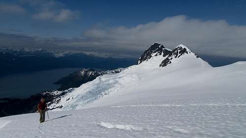
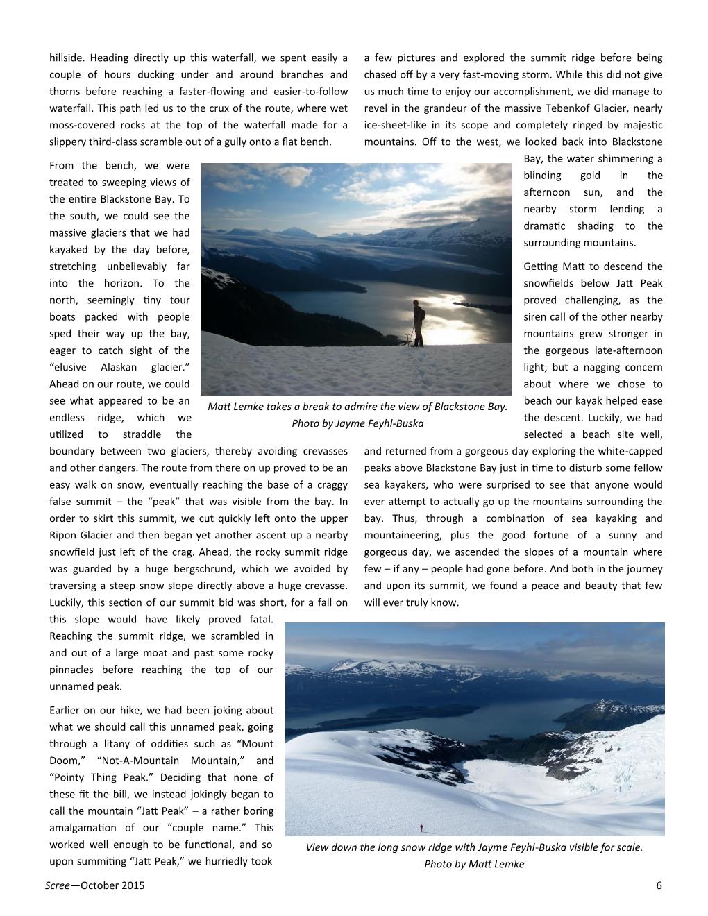
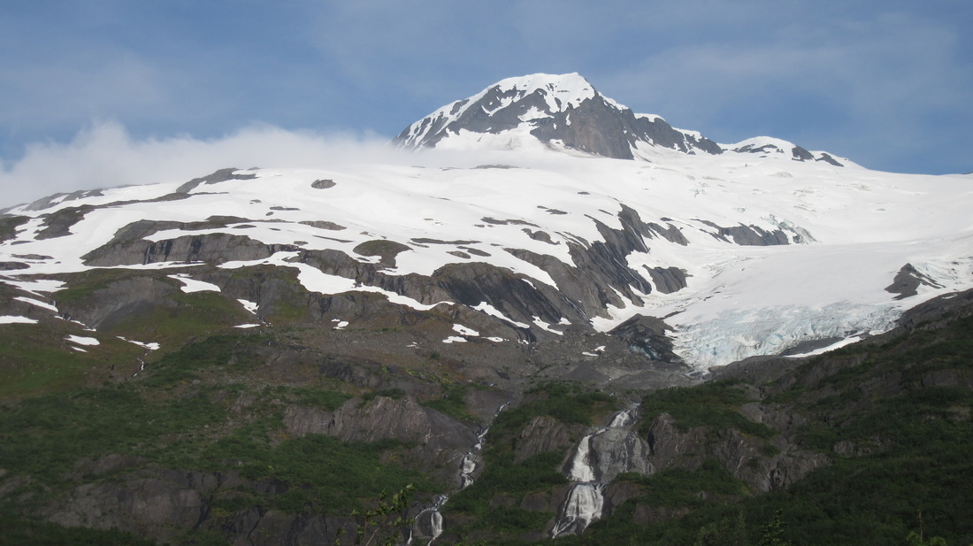
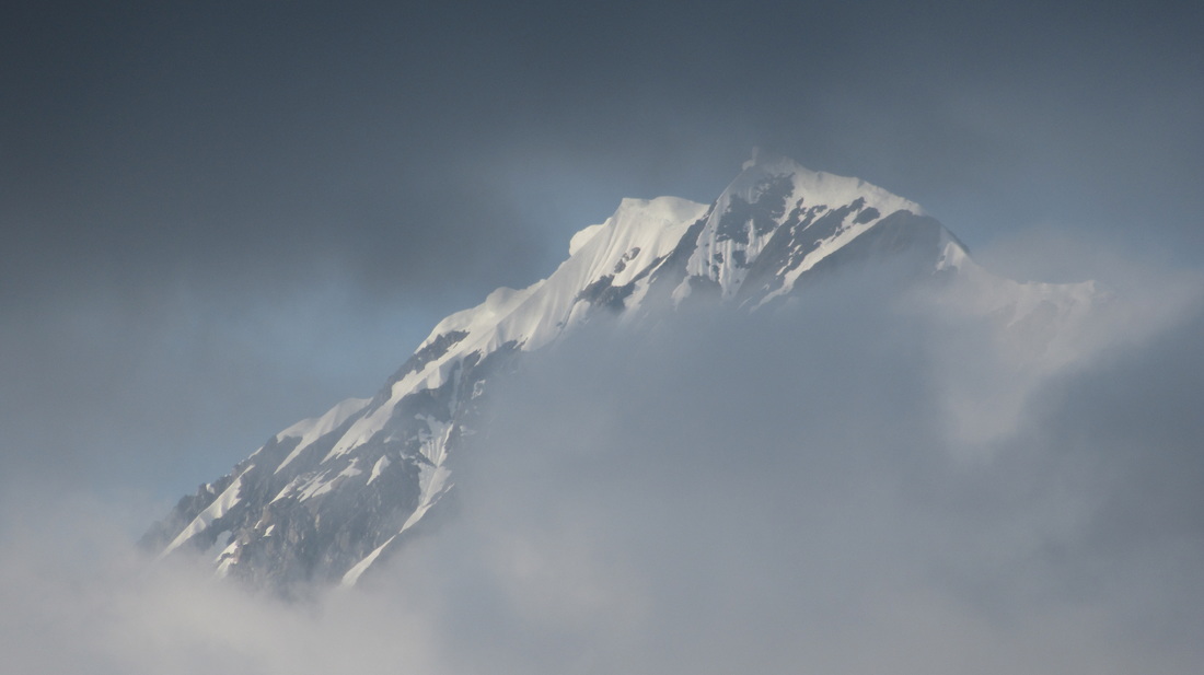
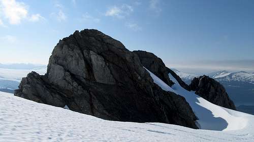
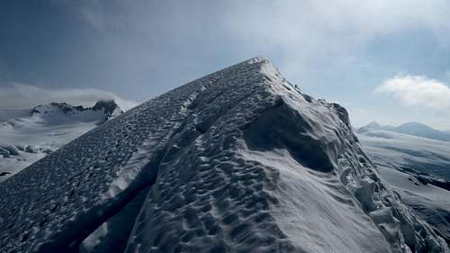
Continue hiking on the snow ridge as it ascends gently for 1 mile at which point you reach the base of the craggy false summit (which is the little rock face visible from the bay). Cut left onto the very upper end of the Ripon Glacier and circle around the north, then east side of this false summit. Stay close (within 100 feet) to the edge of the snow to avoid crevasses. At about 3,300 feet you will reach the end of the snowfield and a large overhanging bergschrund will guard the rocky summit ridge. Traverse a short but steep section of snow to the left (east) above a huge crevasse to get around the schrund and onto the rocks on the summit ridge. A fall without an immediate arrest here would likely be fatal. Once on the summit ridge, turn right and walk SSW up maybe 10 minutes to the summit. You may have to scramble around a couple small pinnacles. The true summit is always covered in a snow mushroom and standing on the highest point invites its collapse, which would dump you 700+ feet down the incredibly rugged SE face. Be smart about where you step!

Jayme hiking up the snow ridge

False summit rocks of Jatt Peak
Hiking around the left of the false summit
Unnamed 3,580 foot peak just north of Jatt Peak
Mount Applegate and the Ripon Glacier

Jayme traversing snow on Jatt Peak
Jayme traversing the steep snow near the summit
Looking up towards jatt Peak
Looking up towards Jatt Peak with the false summit crag

Jayme scrambling a moat near the summit of Jatt Peak

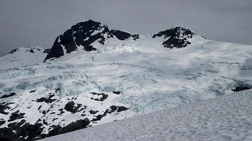
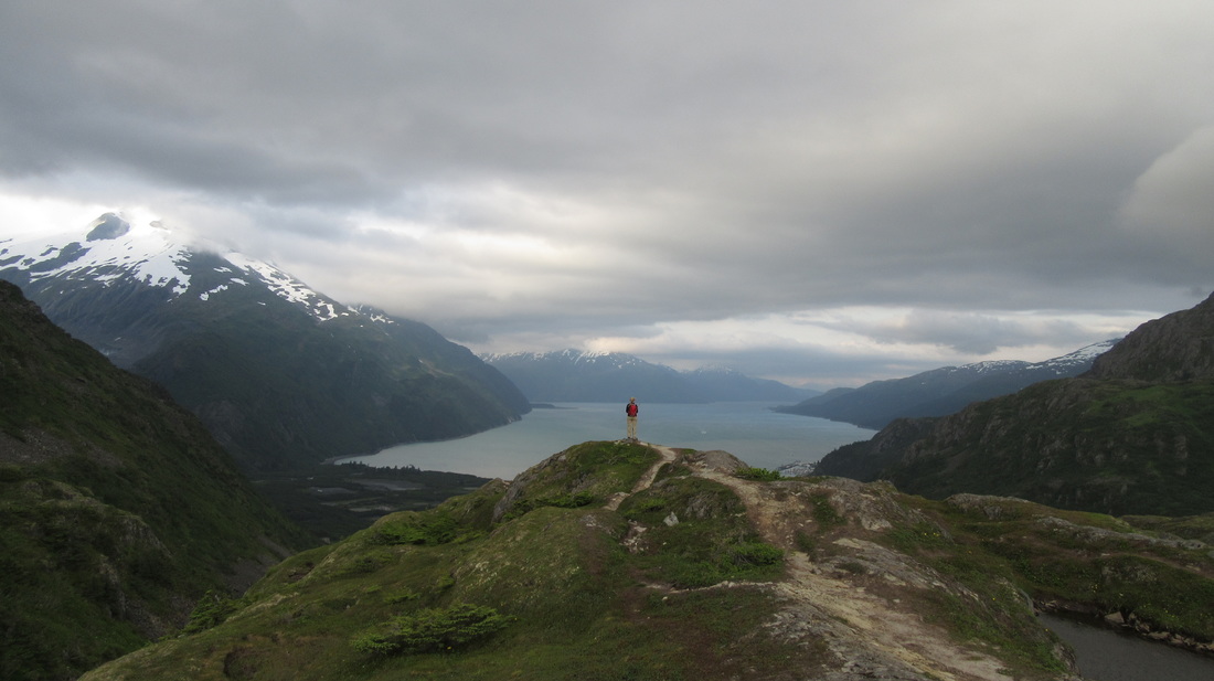
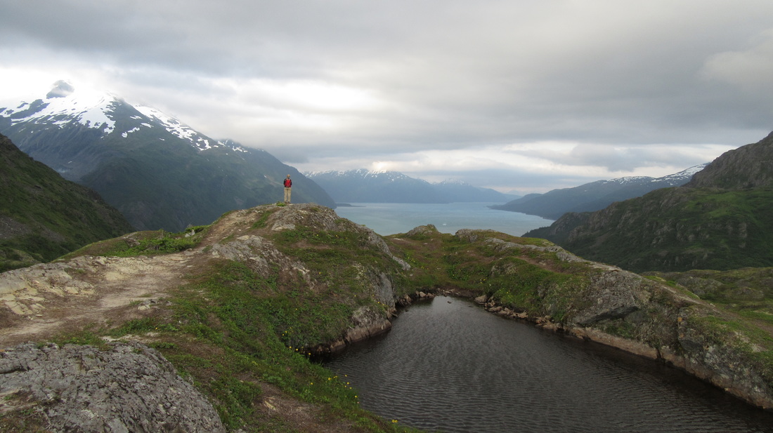
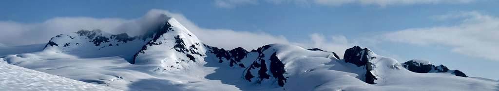
Views from the summit to the east include the enormous Tebenkof Glacier, and the mountains beyond. The area looks like one massive ice-field. Back to the north and west you'll see Blackstone Bay, and the mountains above Whittier. Perhaps the most inspiring are the mountains located to the southwest, where numerous peaks above 5,000 feet are completely encased in ice. Once you are ready to return, retrace your ascent route.


Unnamed big mountains south of Jatt Peak
Summit of Jatt Peak
Summit mushroom of Jatt Peak
Boat headed to the glacier at the head of Blackstone Bay
Jatt Peak summit panorama
Jatt Peak Panoramic View to the Southwest

Camping/Red Tape

Camp at 20 mile beach. There is plenty of fresh water available and a few trees offering shelter from the wind. You will also have plenty of cool sea treasures to find at low tide. There is no red tape at all!


Camping at 20 mile beach

When to Climb

This peak can really be climbed nearly any time of year. If you think sea kayaking in June is cold though, don't do it in January. Remember the days are only 4-5 hours long at Christmas so the realistic climbing season will probably be April-October. In late season, there will be more crevasses to worry about, and it may not be possible to solo the route unroped. In June, it's definitely fairly safe to solo it, assuming you are knowledgeable about glacier travel.

Route Topos

Jatt Peak route topo from Willard Island
Jatt Peak route topo
Jatt Peak route topo from the bay just offshore of 20 mile beach

External Links

Weather Forecast

Alaska Sea Kayakers

Lazy Otter Cafe and Water Taxi

Whittier Information

Whittier Tunnel Information


Trip Report as written in "the scree" - alaska mountaineers club journal

The two photos below are excerpts taken from the October 2015 issue of "The Scree", which is the Alaska Mountaineers Club biannual journal publication. Steve Gruhn approached me via email after I posted my report on Summitpost, and requested Jayme and I write a report for the next issue! He also proclaimed that he did not believe this peak had been climbed before, which meant that Jayme and I had a likely first ascent. Jayme graciously wrote the text for the report, since she was the better writer.
Picture
Picture
Proudly powered by Weebly