LEMKE CLIMBS
  • About
    • Whats New
    • 2019 Goals/Wishlist
    • Contact
  • Washington
    • North Cascades >
      • Sahale Peak, Boston Peak
      • Eldorado Peak, Klawatti Peak
      • Black Peak
      • Forbidden Peak West Ridge
      • Primus Peak Attempt
      • Big Snagtooth
      • Liberty Bell Beckey Route
      • Burgundy Spire North Face 5.8
      • Ragged Ridge - Katsuk, Kimtah and Cosho Peaks
      • Colfax Peak
      • South Early Winters Spire via SW Buttress
      • Chilliwack Mini-Slam
      • Mesahchie Peak
      • Inspiration Traverse
      • Mount Shuksan Ski
      • Full Pickets Traverse
      • Mount Goode NE Buttress & Storm King
      • Mount Baker North Ridge WI3
      • Snowfield Peak
      • Lincoln Peak
      • Silver Star Mountain
      • Mount Buckner & Horseshoe Peak
      • Azurite Peak
      • Tower Mountain & Golden Horn
      • Mount Logan
      • Custer Ridge & Easy Mox
      • Mazama Dome
      • Sherman Peak
      • Mount Ballard
      • Southern Pickets Traverse
      • Corteo Peak
      • Whatcom Peak
      • Castle Peak
    • Glacier Peak Wilderness >
      • Buck Creek Pass, Cloudy Peak, Spider Gap
      • Dome Peak, Spire Point
      • Mt. Maude and Seven Fingered Jack
      • Mount Formidable NE Face 5.6 Second Ascent
      • Dumbell and Greenwood Mountains
      • Glacier Peak Wilderness Mountain Massacre
      • Clark and Luahna Peaks
      • Sinister Peak
      • Chiwawa Mountain
      • Tupshin & Devore Peaks
      • Buck & Fortress Mountains
      • Glacier Peak
      • Snowking Mountain
    • Olympic Peninsula >
      • Buckhorn Mountain
      • Flapjack Lakes Hike
      • Grey Wolf Peak, High Divide Trail
      • Mount Ellinor
      • Mount Constance West Arete
      • Mount Olympus
    • Alpine Lakes Wilderness >
      • Chikamin Peak
      • PCT - Snoqualmie to Pete Lake
      • Necklace and Tank Lakes
      • Enchantments Day Hike
      • Granite Mountain (Snoqualmie)
      • Colchuck Peak
      • Cannon, Enchantment and Stuart
      • Ingalls Peaks
      • McClellan Peak
      • Dragontail Peak
      • Web Mountain
      • Mount Index Attempt
      • Snow Creek Wall Orbit 5.8+
      • The Tooth South Face
      • Eightmile Mountain
      • Argonaut Peak NE Couloir
      • Little Annapurna South Face 5.5
      • Snow Creek Wall Outer Space 5.9
      • Cashmere Mountain
      • Sherpa Peak North Ridge 5.8
      • Chair Peak NE Ridge
      • Lichtenburg Mountain
      • Mount Index
      • McClellan Butte
      • Chimney Rock
      • Alpine Lakes High Route
    • Pasayten Wilderness >
      • The Craggies
      • Tiffany Mountain
      • Pasayten Mini-Slam
      • Remmel Group
      • Jack Mountain
      • Robinson Mountain
      • Monument Peak Group
    • Mountain Loop Highway >
      • Vesper Peak
      • Mount Dickerman
      • Sloan Peak West Face 5.8
      • Mount Forgotten
      • Whitehorse Mountain
      • Gothic Peak
    • Lake Chelan Sawtooth Wilderness >
      • Star, Courtney, and Grey Peaks
      • Hoodoo Peak and Raven Ridge
      • Abernathy Peak
      • Mount Bigelow
      • Reynolds Peak
      • Oval Peak
      • Gardner Peaks
      • Chelan Sawtooth Trio
    • Southern WA >
      • Mount Adams
      • Mount Rainier - Emmons Route
      • Mount Saint Helens
      • Goat Peak
      • Lane Peak, Plummer Peak (Tatoosh)
      • The Unicorn (Tatoosh)
      • Little Tahoma
      • Liberty Cap
    • WA Rock and Ice Cragging >
      • Index Town Walls
      • Vantage
      • Mount Erie
      • Exit 38
      • Leavenworth
  • Colorado
    • San Juan Mountains >
      • Mount Sneffels Lavender Snow Climb
      • Uncompahgre, Matterhorn Peaks
      • Redcloud, Sunshine Peaks
      • San Luis Peak
      • Vermilion, Fuller Peaks
      • Stewart Peak, Baldy Alto
      • Jones, Niagara, American Peaks
      • Wetterhorn Peak, Handies Peak
      • Wilson Group
      • Arrow Peak
      • Mount Sneffels SW Ridge
      • Jagged Mountain, Chicago Basin
      • Teakettle Mountain
      • Dallas Peak
      • Vestal Peak Wham Ridge, Greystone Peak
      • Organ Mountain
      • Phoenix Peak
      • Half Peak
      • Point 13832 Group
      • Golden Horn
      • Mount Sneffels Snake Couloir
      • Pigeon, Turret Peaks
      • Trinity Peaks
    • Elk Mountains >
      • Four Pass Loop
      • Castle, Conundrum Peaks
      • Snowmass Mountain
      • Cathedral Peak
      • South Maroon Peak
      • The Pyramids
      • North Maroon Peak, Sleeping Sexton
      • Capitol Peak, Mount Daly
      • Malemute Peak
      • Hagerman Peak
    • Sangre de Cristo Mountains >
      • Blanca Peak, Ellingwood Point
      • Challenger Point
      • Mount Adams
      • Spread Eagle Peak
      • Humboldt, Obstruction, Columbia Peaks
      • Mount Lindsey, Huerfano Peak
      • Little Bear Peak
      • Crestone Needle Ellingwood Arete
      • California Peak
      • Crestone Peak North Buttress
      • Operation Dark Snake
      • Kit Carson Mountain
    • Sawatch Mountains >
      • Iowa Peak
      • Point 13,618 - Hunky Dory Lake
      • Gold Dust Peak, Notch Mountain
      • Mount Jackson
      • Mount Belford
      • Shavano, Tabeguache Peaks
      • Mount Antero, Cronin Peak
      • Twining Peak
      • Mount Massive
      • Casco Peak
      • Mount Huron
      • Mount Elbert
      • Mount Oxford
      • Mount Hope
      • Mount Yale
      • Lackawanna Peak
      • Mount Columbia
      • La Plata Peak
      • Rinker and Twin Peaks
      • Bull Hill, Mount Princeton
      • Missouri Mountain
      • Mount Oklahoma
      • French Mountain
      • Mount Ouray
      • Grizzly A, Garfield Peaks
      • Mount Harvard
      • The Three Apostles
      • Emerald Peak
      • Holy Cross
      • Mount Aetna
      • Deer Mountain
    • Greater Park Range >
      • Kneeknocker Pass, Piney Lake
      • Drift Peak
      • Sherman Peak, Dyer Peak
      • Gore Range Traverse
      • Quandary Peak
      • Pacific, Atlantic Peaks
      • Clark Peak
      • Crystal Peak, Peak 10
      • Fletcher Mountain
      • The DeCaLiBron
      • Loveland Mountain
      • The Mosquito Traverse
      • Mount Arkansas
      • Clinton Group
      • Eagles Nest, Peak C
      • North Star Mountain
      • Peak X
      • Wheeler Mountain
    • Front Range >
      • Mount Evans, Spalding
      • Mount Bierstadt
      • Mount Parnassus, Bard Peak
      • Cupid, Sniktau, Grizzly D Peaks
      • James Peak
      • Mount Silverheels
      • Grays and Torreys Peaks
      • Mount Edwards
      • Mount Flora, Longs Peak
      • Square Top Mountain
      • Petit Grepon South Face 5.8
      • Mount Meeker Dreamweaver Couloir
      • Santa Fe Peak
      • The Citadel & Pettingell
    • Colorado Ice Climbing >
      • Lincoln Ice Falls
      • Ouray Ice Park
      • Avocado Gully and The Drool
      • Hidden Falls
    • Colorado Rock Climbing >
      • Eldorado Canyon
      • The Flatirons
      • North Table Mountain
      • Colorado National Monument >
        • Independence Monument
  • Wyoming
    • Wind River Mountains >
      • Gone With the Winds
      • Union Peak - Solar Eclipse
      • Wind River Peak
      • Wind River Slam
    • Teton Range >
      • Grand Teton Owen Spalding 5.4
      • Mount Owen Attempt
    • Wyoming Absarokas and Gros Ventre Range >
      • Jackson Peak
      • Francs Peak
    • Yellowstone National Park >
      • Top Notch Peak
    • Bighorn Range and Great Divide Basin >
      • Boars Tusk
      • Loaf Mountain
      • Cloud Peak
      • Black Tooth Mountain
    • Devils Tower
    • Cody Rock and Ice Climbing
  • Montana
    • Beartooth Mountains >
      • Whitetail Peak Group
      • Beartooth Mountain
      • Spirit Mountain Group
      • Mount Peal
      • Granite Peak Group
      • Castle Rock Group
      • Castle Mountain NE Couloir
      • Mount Inabnit and Sylvan Peak
      • Mount Hague South Slopes
      • Mount Villard and The Granite Peaks Traverse - 5.4
      • Spirit Mountain NE Ridge - 5.4
      • California Ice WI 4
      • The Ramp 5.8
      • Linea Alba 5.10d
      • Iceberg Peak
      • Metcalf Mountain North Rib 5.8
      • Villard Spires HP West Ramp
      • Cairn Mountain
      • Snowbank Mountain
      • Mount Wood Group
      • Bears Tooth
      • Glacier Peak Catch-a-Sunrise FA
    • Southwest Montana Ranges >
      • Madison Range >
        • Koch Peak
        • Sphinx Mountain
        • Beehive Peak
        • South Sheep Mountain
      • Gallatin Range
      • Bridger Range >
        • Sacajawea Peak
        • Saddle Peak
        • Baldy Mountain
        • Ross Peak
      • Montana Absorakas >
        • Arrow Peak
        • Black Mountain
        • Mount Cowen
      • Tobacco Root Mountains >
        • Hollowtop Mountain
        • Belle Point
        • Noble Peak
        • Leggat Mountain
      • Crazy Mountains >
        • Crazy Peak
    • Glacier National Park >
      • A Taste of Glacier National Park
      • Divide Mountain
    • MT Rock and Ice Climbing
  • Utah
    • Uinta Mountains >
      • Kings-Emmons Ridge Run
      • Hayden Peak
      • Iron Hayden Wall Rock Climbing
    • Wasatch Range >
      • The Sundial Eleventh Hour 5.8
      • Mount Timpanogos
    • San Rafael Swell >
      • Ramp, Cistern Canyons
      • Salt Wash, Black Mountain, Moroni Slopes
      • Ding, Dang Canyons
      • Little Wild Horse, Bell Canyons
      • Quandary Canyon
      • San Rafael Knob
      • Miners Hollow (Knotted Rope Canyon)
      • Temple Mountain
      • Chimney Rock
      • Bottleneck Mesa
      • Window Blind Peak
      • Lower Baptist Draw & Upper Chute Canyon
    • Capitol Reef National Park >
      • Cathedral Valley Tour
      • Sheets Gulch
      • Halls Creek Narrows
      • Brimhall Canyon and Strike Valley Overlook
      • George Benchmark
    • Moab Area, Canyonlands, Arches >
      • Maze District
      • Needles District
      • Maze District
      • White Rim Trail Biking
      • Elephant Butte, Bullwinkle Tower and Lizard Rock
      • South Six Shooter
      • Elephant Canyon
      • Parriott Mesa
      • Ancient Art
      • Castleton Tower North Chimney 5.8
      • Klondike Bluffs
      • Mount Peale & Tukuhnikivatz
    • Robbers Roost Country >
      • Horseshoe Canyon, Goblin Valley
      • Bluejohn Canyon
      • Happy Canyon Narrows
      • Shenanigans, Leprechaun Slots
      • Larry Canyon
      • Merry Piglet Slot
      • Lower Maidenwater Canyon, Turkey Knob
      • Morocco Canyon
      • Monkey Business Slot
      • Hog Canyon Slots
      • Upper Maidenwater Canyon Slots
      • Mount Ellen
      • Buck Canyon
      • Point 4906
      • Alcatraz Canyon
      • Hard Day Harvey Slot
      • Mount Ellsworth
      • Good Day Jim Canyon
      • White Roost Canyon
      • Upper Stair Canyon
      • Dragon Canyon
    • Escalante National Monument >
      • Phipps Canyon and Arch
      • Red Breaks Slot
      • Dry Fork Slots, Coyote Gulch
      • Little Death Hollow/Wolverine Canyons
      • Egypt 3 Slot
      • Egypt 1 Canyon
    • Zion/Bryce >
      • Ataxia Tower Ashtar Command 5.9
      • Mount Kinesava Cowboy Ridge
      • Birch Hollow
      • Aires Butte
      • West Temple
      • Mystery Canyon
      • Crazy Streak
    • Cedar Mesa Region/Valley of the Gods >
      • Eagle Plume Tower Eagle Feather 5.10b
  • California
    • High Sierras, Southern CA Ranges >
      • Telescope Peak, Manly Beacon
      • Tahquitz Rock Whodunit 5.9
      • Tahquitz Rock Long Route 5.9
      • Palisade Traverse
      • White Mountain
    • Yosemite National Park, Central CA
    • Northern CA Cascades >
      • Lava Beds National Monument
      • Mount Shasta
  • Oregon
    • Oregon Volcanoes >
      • Three Fingered Jack
      • Mount Scott
    • Blue Mountains >
      • Twin Peaks
    • Trout Creek Rock Climbing
  • Alaska
    • Eagle Peak and Mount Ewe
    • Jatt Peak and Portage Pass
    • Rainbow Peak
    • Mount Brooks Attempt
    • Arrigetch Peaks Trek
    • Ab Mountain Hike
    • South Suicide Peak
    • Mount Hunter West Ridge Attempt
    • Cantata Peak Attempt
    • East Twin Peak
    • Mount Alice
    • Crow Pass and Hope Point Hikes
    • Indianhouse Mountain Attempt
    • Lynx Peak
    • Harding Icefield Hike
    • Hatcher Pass and Grapefruit Rocks Climbing
    • Mount Sanford
    • Mount Hunter West Ridge
    • Mount Fairweather
  • Nevada
    • Ginger Cracks 5.8
    • Mescalito Dark Shadows 5.8
    • Birdland and Olive Oil
    • Frogland 5.8
    • Johnny Vegas 5.8
    • Schaeffer's Delight & Triassic Sands
    • Solar Slab - 5.6
  • British Columbia
    • Mount Matier
    • Taiya Peak
    • Bugaboo Spire NE Ridge
    • Mount Sabine Easy Honey 5.10b
    • Mount Sir Donald NW Ridge Attempt
    • Black Tusk
    • Slesse Mountain NE Buttress
    • Warden Peak
    • Triple Peak
    • Gimli Peak
    • Mount Waddington
  • Alberta
    • Mist Ridge Hike
    • Mount Temple Attempt
    • East Wendell Peak
    • Loder Peak
    • Tower Mountain Attempt
    • The Rimwall
    • Mount Yamnuska Directissima 5.9
    • Mount Lawrence Grassi
    • Mount Lorette
    • Roche A Perdrix
    • Mount Edith Cavell East Ridge 5.3
    • Mount Louis Kain Route
    • Eiffel Peak
    • Mount Alberta
    • Canadian Rockies Ice Climbing
  • Other States
    • Arizona >
      • Grand Canyon Bright Angel Trail
      • Beanfest at Cochise Stronghold
      • Baboquivari Peak
      • Humphreys Peak
    • New Mexico >
      • Philmont Trek August 2008
    • Yukon >
      • Canyon Peak
  • International
    • Mexico & Central America >
      • Mexico - Pico de Orizaba, Izta
      • Guatemala Volcanoes
    • South America >
      • Chile >
        • An Introduction to Patagonia
        • Exploring Pucon and Lanin Volcano
        • Cerro Puntado & Palo
        • Cerro Colorado
        • Cerro Puno & Agudo
        • Cerro Trinidad Attempt
        • Volcan Quetrupillan
        • Cerro Placas
        • Volcan Puyehue
        • Cerro Conico
        • Cerro Barros Arana
        • Cerro Cordillerano
        • Ojos del Salado
      • Argentina >
        • Nahuel Huapi National Park & The Frey
        • Cerro Helio Azul & Tronador Attempt
        • Aguja Guillaumet Amy Couloir
        • Nevado de Acay
        • Chiaro de Luna
      • Peru >
        • Cordillera Blanca - Tocllaraju and Urus
        • Cordillera Blanca - Ishinca Peak and Artesonraju
        • Cordillera Blanca - Quitaraju & Alpamayo
        • Exploring Southern Peru
      • Bolivia >
        • Pequeno Alpamayo
        • Huayna Potosi
        • Illimani
    • Oceania >
      • Exploring New Zealand's South Island
      • Puncak Jaya
      • Mount McPherson and Talbot
      • Single Cone
      • Mount Cook
      • Mount Aspiring
      • Manakau
      • Mount Wilhelm
    • Central Asia >
      • Kyrgyzstan 2021
    • Europe >
      • Iceland & Faroe >
        • Snaefellsjokull
        • Kaldbakur
        • Slaettaratindur
  • Sorted by Year
    • 2008 Trip Reports
    • 2009 Trip Reports
    • 2010 Trip Reports
    • 2011 Trip Reports
    • 2012 Trip Reports
    • 2013 Trip Reports
    • 2014 Trip Reports
    • 2015 Trip Reports
    • 2016 Trip Reports
    • 2017 Trip Reports
    • 2018 Trip Reports
    • 2019 Trip Reports
    • 2020 Trip Reports
    • 2021 Trip Reports
    • 2022 Trip Reports
    • 2023 Trip Reports
  • Vanlife
    • Conversion Journal >
      • Floor Installation
      • Folding Bed
      • Coffee Table
      • Thinsulate Installation
      • The Couch
      • The Wardrobe
      • Bookshelf
      • Water System
      • Electrical System
      • The Pantry
      • Refrigerator
      • Tire Upgrade
      • Heating System
      • Composting Toilet
LEMKE CLIMBS

Eagle Peak & Mount ewe

eagle peak - 6909' - south face class 3
​mount ewe - 6292' - north ridge class 2+
​june 2015

When Jayme and I first arrived in Alaska in mid June, we were picked at the airport up by Lynne who lives in Anchorage. She was kind enough to drive us to the Eagle Lake Trailhead where we scouted out some routes up a few peaks in the area. I had sights on the Chugach Range before we even landed in Alaska so I had some idea already, but Eagle Peak, Organ Mountain and Flute Peak were the three I was most interested in. We would only get one of the three, but the trip was still a success. We started hiking at 9pm towards Eagle Lake, and because of the very long days, there was still plenty of alpenglow by the time we reached our chosen camp spot near the old cabin at midnight. We stayed on the ridge separating Eagle and Symphony Lakes, and was able to enjoy the alpenglow for hours!

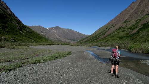
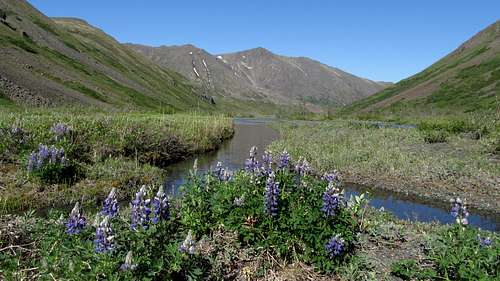
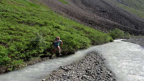
The next morning we continued to the upper end of Eagle Lake and hiked east up the flat valley, crossing Eagle Creek numerous times as we tried to avoid bushwhacking. For the most part we were ok but I had to help Jayme get across a couple of the stream crossings as they were roaring! I recalled making a few flying leaps to avoid taking my shoes off and wading (I'm lazy!). I would actually go to great lengths to keep my shoes on. The large waterfall coming down was a cool sight, but not something you wanted to fall into. Once we got to the base of the waterfall, we hiked up the large talus slope to the left of the waterfall and above the first step towards the Flute Glacier. We utilized small game trails for this ascent, which did have a good amount of scree to deal with. Many wildflowers could be seen the entire hike. I loved it!

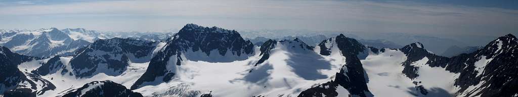
From there we followed the valley as it turned south and went up a second step of only 300 feet, and located a good camp spot in some grass with excellent views of Eagle Peak. We set up camp and took a nice break before continuing on to the Flute Glacier. I think it was about 5pm when we reached the terminus of the glacier, and we decided to keep going, since we had so much daylight. We ascended the gentle snow on the rightmost edge of the glacier and went up the large elevated bench above and west of the main Flute Glacier. This area didn't appear to be an actual glacier so we felt comfortable just hiking up the snow. We eventually reached the north ridge of Mount Ewe and scrambled our way to the summit, which we reached around 8pm or so. Unfortunately some smoke from a new wildfire obscured the really awesome views but we still enjoyed the panoramic Alaskan mountains. I kept wanting to traverse over to Flute Peak but I knew that would take a long time, and it looked technical. I decided against it and we simply retraced our steps back to camp, but when we passed by the end of the Flute Glacier, there was a solo hiker from Anchorage resting on a rock. It turned out he also wanted to do Eagle Peak the next day so I agreed to meet him at his proposed bivy spot early in the morning, and we would climb it together. We followed the south face route described below, and loved every minute of it. Plenty of exposed, difficult scrambling with some snow climbing mixed in.

When I returned to camp around 3pm I went right to sleep, and awoke a few ours later to a clap of thunder! Apparently Alaska does get thunderstorms...although it didn't last long. We ended up sleeping the rest of the day and that night and hiked out the next morning back to the trailhead.

Eagle Peak Information

Overview

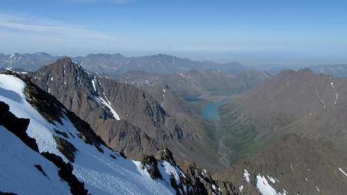
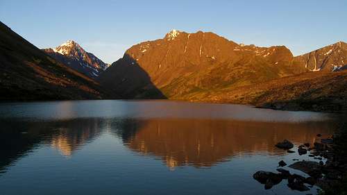
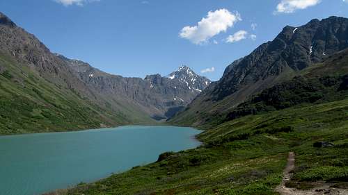
Eagle Peak is a rugged, stout peak located in the Western Chugach Mountains just east of Anchorage. At 6,909 feet in elevation with 1,602 feet of prominence, Eagle Peak is one of the highest peaks in the surrounding area. Nearby Organ Mountain is only slightly higher. When one hikes the South Fork of the Eagle River, and reaches the large Eagle Lake, this peak towers high above you to the east across the lake. At night in the summer, the deep red glow of the rugged west face stays lit for hours giving photographers a rare dream of experiencing the "3 hour alpenglow". Camping at Eagle Lake is highly recommended to get a chance to experience this divine sight!

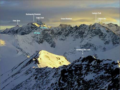
For those interested in ascending this peak, there is a scramble route that heads up the south face which tops out at Class 3, albeit very loose. It is recommended as a springtime ascent when firm snow covers the loose rock however a summertime ascent is still very doable. Just bring a helmet and don't go in a large party. The views of Cantata, Calliope, Organ, Flute, and Ewe from the summit are breathtaking!


Organ Mountain and Flute Peak from Eagle Peak standard route


Getting There

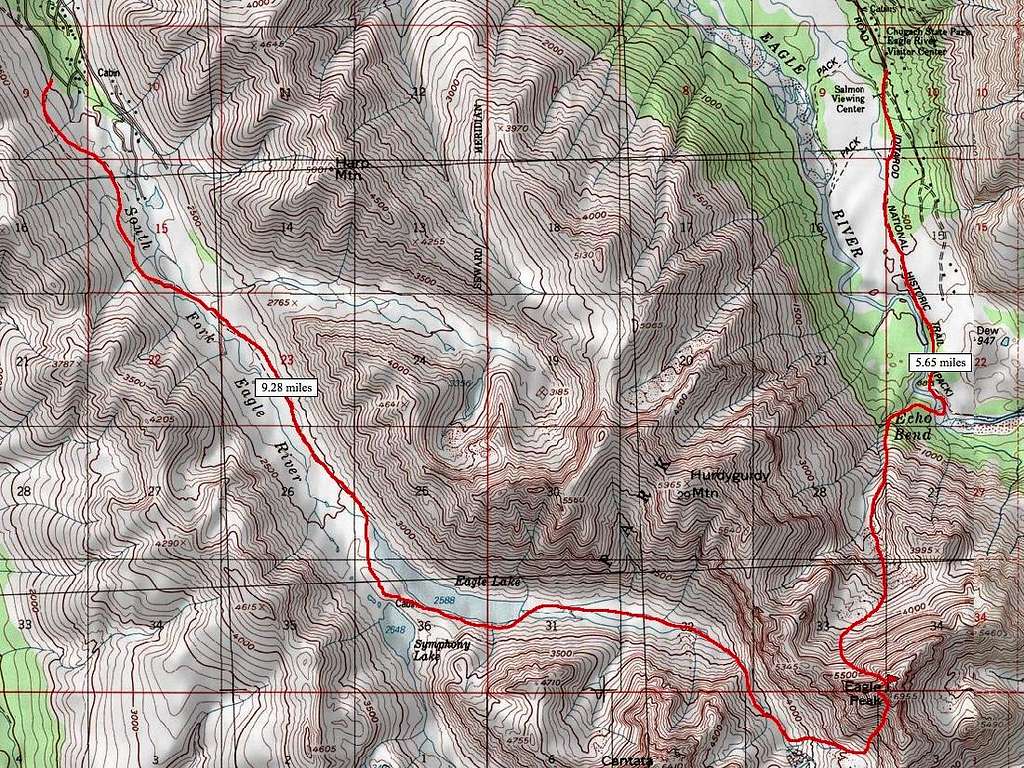
From Anchorage: Starting in downtown Anchorage, follow 6th Avenue east as it turns into Alaska Highway 1. Stay on Highway 1 for 11.5 miles and take the Hiland Road/Eagle River Loop exit and veer right. Take an immediate right onto Hiland Road (do not continue on the Eagle River Loop Road). Continue on Hiland Road, as it weaves its way up the South Fork of Eagle River. About 8 miles from the exit, turn right onto S Creek Road and cross the river over on a bridge. The road ends at the trailhead (elevation 1,965 feet) where there is room for about 25 cars.

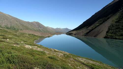
Hike the very nice trail about 4.5 miles to Eagle Lake. The first third of the trail stays well off to the right and above the river to avoid private property, then crosses to the east side on a nice bridge. Just before the lake there is a bridge crossing back to the west side. From here, there is a cairned path marking the best way through the large talus and boulder field. Follow this path around the south side of Eagle Lake. You will pass by an old cabin on the small ridge separating Eagle Lake from Symphony Lake. There are many great places to camp in this area offering incredible views of Eagle Peak, Cantata Peak and both lakes.


Sunset on Eagle Peak
Cantata and Triangle Peaks from Eagle Lake
Eagle Lake
Eagle Lake
Midnight sun from camp at Eagle Lake


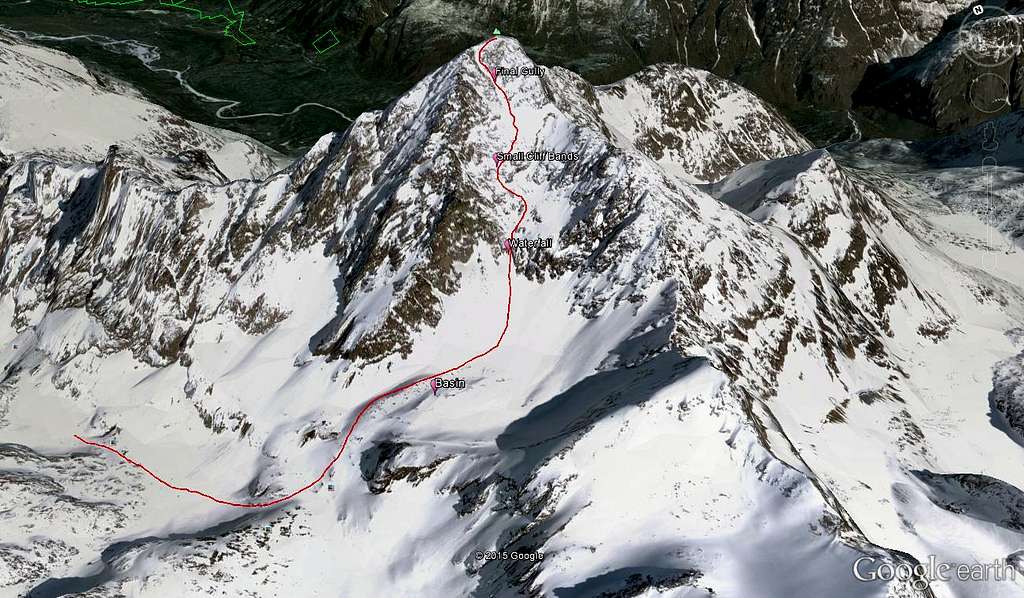
Standard Route - South Face - Class 3

From Eagle Lake, continue following a faint trail which leads to the upper, east end of the lake. This path stays roughly 100 feet above the lake until reaching a buttress, at which point the trail descends to the lake and reaches the inlet stream. In summer, the remainder of the approach can be annoying for two reasons. You will have to wade across the stream numerous times, and there will be some bushwhacking. It is recommended you cross the inlet stream right as it dumps into the lake and stay on the north side for a little while. You will however be forced to cross back and forth at least twice to avoid awful bushwhacking. Most Alaskans wear old tennis shoes for approaches because it makes wading easy...you just accept the fact your feet will get wet and walk through the streams. We didn't do that and had to take our boots off at least 4 times. You will gain very little elevation on this part of the approach as the valley is wide and flat. Eagle Peak looms above the whole time sending chills down your spine, but you can be assured, you will not be climbing the face you see from the valley, or any part of the approach. The south face doesn't become visible until you are on it!


Eagle Lake
Eagle Lake
So many creek crossings!
Typical creek crossing above Eagle Lake
Lupine flowers in the Eagle Lake valley
Lupine flowers in the Eagle River valley


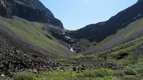
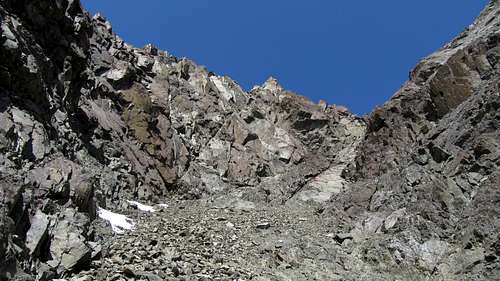
As the valley gets narrower and begins to curve to the right, make sure you cross to the north side of the river before the terrain steepens. Do not try and cross the river too close to the raging waterfall coming down from the upper valley. Even on the driest years this is very dangerous. Once you reach the base of the ~500 foot waterfall (about 2,800 feet), begin hiking steeply up to the left on the talus and scree slopes. A faint path follows a small gully and makes the ascent easier, however it's hard to find from below. Simply head up until you are able to begin traversing right and pass above the cliffs. At around 3,350 feet, you will have ascended high enough to enter the valley above the waterfall. From here, continue about a quarter mile up flat terrain and ascend a 200 foot slope (ie. the second of three steps), passing left of a deeply inset 60 foot waterfall that remains hidden until you can look directly inside the canyon. At the top of this slope there is a couple nice camp spots, however most of the valley at this point is covered with boulders.


The waterfall guarding the Flute Glacier
The 500 foot waterfall
Jayme makes a long jump!
Looking down the South Fork of the Eagle River


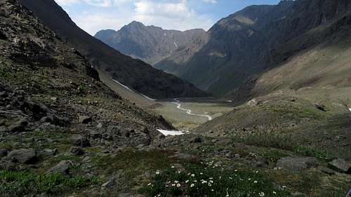
Continue up the once again flat valley for another half mile, at which point you will begin ascending loose talus eastward. At 3,700 feet the ascent really begins. Head east up talus or snow for 900 feet and enter the large basin to the south of Eagle Peak. Take a rest here because the rest of the climb is sustained and steep, loose class 2 and 3. Climb 700 feet up a hideous scree field (hopefully you went in May or June wen it's snow covered) aiming for a waterfall gully coming down from the south face. If this slope is snow covered, an ice axe is mandatory as it is about 40 degrees. Upon reaching the waterfall at 5,250 feet, climb the slabs to the left of the waterfall (Class 3+). This is the crux of the route and it may be wet so be careful. Above the crux, the terrain mellows out for awhile. Just continue up the gully hitting there snow where it lingers. A few hundred feet above the waterfall, scramble up to the left and climb through a few small cliff bands (Class 3). Do not continue off to the right in a NE direction as this gully won't reach the summit due to a large set of cliffs. Once you reach 6,000 feet in elevation, you can traverse back to the right on a large, talus covered slope above the huge cliff band just mentioned.


Eagle Peak from the valley
The scree field leading to the waterfall on Eagle Peak
One of the cruxes on Eagle Peak


Looking up the upper gully
Final stroll to the summit of Eagle Peak


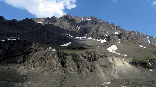
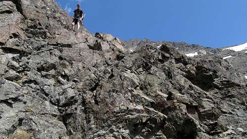
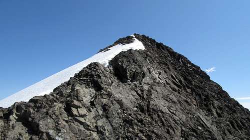
At 6,200 feet you will notice two gullies heading straight up. Be sure to take the right gully and follow it 600 feet up as it weaves left, then back to the right and reaches the upper west ridge at 6,800 feet. Be extra careful in this gully as the rock is very loose (Class 2). Once on the west ridge, turn right (east) and walk easily to the summit. Descend the same way.


Eagle Lake from Eagle Peak
Polar Bear Peak from Eagle Peak
Cantata and Calliope Peaks from Eagle Peak


Camping/Red Tape

Great camping can be found at Eagle Lake or at the top of the second step. There is no red tape. Amazingly, this entire mountainous region is a state park!


Peak ID
Eagle Peak and surrounding area under snow


Maps

Eagle Peak South Face Route Overview
Eagle Peak Map
Eagle Peak map showing the south and north face routes

External Links

Weather Forecast

Excellent TR of a climb up the north face

Proudly powered by Weebly