LEMKE CLIMBS
  • About
    • Whats New
    • 2019 Goals/Wishlist
    • Contact
  • Washington
    • North Cascades >
      • Sahale Peak, Boston Peak
      • Eldorado Peak, Klawatti Peak
      • Black Peak
      • Forbidden Peak West Ridge
      • Primus Peak Attempt
      • Big Snagtooth
      • Liberty Bell Beckey Route
      • Burgundy Spire North Face 5.8
      • Ragged Ridge - Katsuk, Kimtah and Cosho Peaks
      • Colfax Peak
      • South Early Winters Spire via SW Buttress
      • Chilliwack Mini-Slam
      • Mesahchie Peak
      • Inspiration Traverse
      • Mount Shuksan Ski
      • Full Pickets Traverse
      • Mount Goode NE Buttress & Storm King
      • Mount Baker North Ridge WI3
      • Snowfield Peak
      • Lincoln Peak
      • Silver Star Mountain
      • Mount Buckner & Horseshoe Peak
      • Azurite Peak
      • Tower Mountain & Golden Horn
      • Mount Logan
      • Custer Ridge & Easy Mox
      • Mazama Dome
      • Sherman Peak
      • Mount Ballard
      • Southern Pickets Traverse
      • Corteo Peak
      • Whatcom Peak
    • Glacier Peak Wilderness >
      • Buck Creek Pass, Cloudy Peak, Spider Gap
      • Dome Peak, Spire Point
      • Mt. Maude and Seven Fingered Jack
      • Mount Formidable NE Face 5.6 Second Ascent
      • Dumbell and Greenwood Mountains
      • Glacier Peak Wilderness Mountain Massacre
      • Clark and Luahna Peaks
      • Sinister Peak
      • Chiwawa Mountain
      • Tupshin & Devore Peaks
      • Buck & Fortress Mountains
      • Glacier Peak
      • Snowking Mountain
    • Olympic Peninsula >
      • Buckhorn Mountain
      • Flapjack Lakes Hike
      • Grey Wolf Peak, High Divide Trail
      • Mount Ellinor
      • Mount Constance West Arete
      • Mount Olympus
    • Alpine Lakes Wilderness >
      • Chikamin Peak
      • PCT - Snoqualmie to Pete Lake
      • Foss Lakes Hike
      • Necklace and Tank Lakes
      • Enchantments Day Hike
      • Granite Mountain (Snoqualmie)
      • Colchuck Peak
      • Cannon, Enchantment and Stuart
      • Ingalls Peaks
      • McClellan Peak
      • Dragontail Peak
      • Web Mountain
      • Mount Index Attempt
      • Snow Creek Wall Orbit 5.8+
      • The Tooth South Face
      • Eightmile Mountain
      • Argonaut Peak NE Couloir
      • Little Annapurna South Face 5.5
      • Snow Creek Wall Outer Space 5.9
      • Cashmere Mountain
      • Sherpa Peak North Ridge 5.8
      • Chair Peak NE Ridge
      • Lichtenburg Mountain
      • Mount Index
      • McClellan Butte
      • Chimney Rock
      • Alpine Lakes High Route
    • Pasayten Wilderness >
      • The Craggies
      • Tiffany Mountain
      • Pasayten Mini-Slam
      • Remmel Group
      • Jack Mountain
      • Robinson Mountain
      • Monument Peak Group
    • Mountain Loop Highway >
      • Vesper Peak
      • Mount Dickerman
      • Sloan Peak West Face 5.8
      • Mount Forgotten
      • Whitehorse Mountain
      • Gothic Peak
    • Lake Chelan Sawtooth Wilderness >
      • Star, Courtney, and Grey Peaks
      • Hoodoo Peak and Raven Ridge
      • Abernathy Peak
      • Mount Bigelow
      • Reynolds Peak
      • Oval Peak
      • Gardner Peaks
      • Chelan Sawtooth Trio
    • Southern WA >
      • Mount Adams
      • Mount Rainier - Emmons Route
      • Mount Saint Helens
      • Goat Peak
      • Lane Peak, Plummer Peak (Tatoosh)
      • The Unicorn (Tatoosh)
      • Little Tahoma
      • Liberty Cap
    • WA Rock and Ice Cragging >
      • Index Town Walls
      • Vantage
      • Mount Erie
      • Exit 38
      • Leavenworth
  • Colorado
    • San Juan Mountains >
      • Mount Sneffels Lavender Snow Climb
      • Uncompahgre, Matterhorn Peaks
      • Redcloud, Sunshine Peaks
      • San Luis Peak
      • Vermilion, Fuller Peaks
      • Stewart Peak, Baldy Alto
      • Jones, Niagara, American Peaks
      • Wetterhorn Peak, Handies Peak
      • Wilson Group
      • Arrow Peak
      • Mount Sneffels SW Ridge
      • Jagged Mountain, Chicago Basin
      • Teakettle Mountain
      • Dallas Peak
      • Vestal Peak Wham Ridge, Greystone Peak
      • Organ Mountain
      • Phoenix Peak
      • Half Peak
      • Point 13832 Group
      • Golden Horn
      • Mount Sneffels Snake Couloir
      • Pigeon, Turret Peaks
    • Elk Mountains >
      • Four Pass Loop
      • Castle, Conundrum Peaks
      • Snowmass Mountain
      • Cathedral Peak
      • South Maroon Peak
      • The Pyramids
      • North Maroon Peak, Sleeping Sexton
      • Capitol Peak, Mount Daly
      • Malemute Peak
      • Hagerman Peak
    • Sangre de Cristo Mountains >
      • Blanca Peak, Ellingwood Point
      • Challenger Point
      • Mount Adams
      • Spread Eagle Peak
      • Humboldt, Obstruction, Columbia Peaks
      • Mount Lindsey, Huerfano Peak
      • Little Bear Peak
      • Crestone Needle Ellingwood Arete
      • California Peak
      • Crestone Peak North Buttress
      • Operation Dark Snake
      • Kit Carson Mountain
    • Sawatch Mountains >
      • Iowa Peak
      • Point 13,618 - Hunky Dory Lake
      • Gold Dust Peak, Notch Mountain
      • Mount Jackson
      • Mount Belford
      • Shavano, Tabeguache Peaks
      • Mount Antero, Cronin Peak
      • Twining Peak
      • Mount Massive
      • Casco Peak
      • Mount Huron
      • Mount Elbert
      • Mount Oxford
      • Mount Hope
      • Mount Yale
      • Lackawanna Peak
      • Mount Columbia
      • La Plata Peak
      • Rinker and Twin Peaks
      • Bull Hill, Mount Princeton
      • Missouri Mountain
      • Mount Oklahoma
      • French Mountain
      • Mount Ouray
      • Grizzly A, Garfield Peaks
      • Mount Harvard
      • The Three Apostles
      • Emerald Peak
      • Holy Cross
      • Mount Aetna
    • Greater Park Range >
      • Kneeknocker Pass, Piney Lake
      • Drift Peak
      • Sherman Peak, Dyer Peak
      • Gore Range Traverse
      • Quandary Peak
      • Pacific, Atlantic Peaks
      • Clark Peak
      • Crystal Peak, Peak 10
      • Fletcher Mountain
      • The DeCaLiBron
      • Loveland Mountain
      • The Mosquito Traverse
      • Mount Arkansas
      • Clinton Group
      • Eagles Nest, Peak C
      • North Star Mountain
      • Peak X
      • Wheeler Mountain
    • Front Range >
      • Mount Evans, Spalding
      • Mount Bierstadt
      • Mount Parnassus, Bard Peak
      • Cupid, Sniktau, Grizzly D Peaks
      • James Peak
      • Mount Silverheels
      • Grays and Torreys Peaks
      • Mount Edwards
      • Mount Flora, Longs Peak
      • Square Top Mountain
      • Petit Grepon South Face 5.8
      • Mount Meeker Dreamweaver Couloir
      • Santa Fe Peak
      • The Citadel & Pettingell
    • Colorado Ice Climbing >
      • Lincoln Ice Falls
      • Ouray Ice Park
      • Avocado Gully and The Drool
      • Hidden Falls
    • Colorado Rock Climbing >
      • Eldorado Canyon
      • The Flatirons
      • North Table Mountain
      • Shelf Road
      • Colorado National Monument >
        • Independence Monument
  • Wyoming
    • Wind River Mountains >
      • Gone With the Winds
      • Union Peak - Solar Eclipse
      • Wind River Peak
      • Wind River Slam
    • Teton Range >
      • Grand Teton Owen Spalding 5.4
      • Mount Owen Attempt
    • Wyoming Absarokas and Gros Ventre Range >
      • Jackson Peak
      • Francs Peak
    • Yellowstone National Park >
      • Top Notch Peak
    • Bighorn Range and Great Divide Basin >
      • Boars Tusk
      • Loaf Mountain
      • Cloud Peak
      • Black Tooth Mountain
    • Devils Tower
    • Cody Rock and Ice Climbing
  • Montana
    • Beartooth Mountains >
      • Whitetail Peak Group
      • Beartooth Mountain
      • Spirit Mountain Group
      • Mount Peal
      • Granite Peak Group
      • Castle Rock Group
      • Castle Mountain NE Couloir
      • Mount Inabnit and Sylvan Peak
      • Mount Hague South Slopes
      • Mount Villard and The Granite Peaks Traverse - 5.4
      • Spirit Mountain NE Ridge - 5.4
      • California Ice WI 4
      • The Ramp 5.8
      • Linea Alba 5.10d
      • Iceberg Peak
      • Metcalf Mountain North Rib 5.8
      • Villard Spires HP West Ramp
      • Cairn Mountain
      • Snowbank Mountain
      • Mount Wood Group
      • Bears Tooth
      • Glacier Peak Catch-a-Sunrise FA
    • Montana Absarokas & Gallatin Range >
      • Black Mountain
    • Southwest Montana Ranges >
      • Sacajawea Peak
      • Arrow Peak
      • Koch Peak
      • Saddle Peak
      • Baldy Mountain
      • Sphinx Mountain
    • Glacier National Park >
      • A Taste of Glacier National Park
      • Divide Mountain
    • MT Rock and Ice Climbing
  • Utah
    • Uinta Mountains >
      • Kings-Emmons Ridge Run
      • Hayden Peak
      • Iron Hayden Wall Rock Climbing
    • Wasatch Range >
      • The Sundial Eleventh Hour 5.8
      • Mount Timpanogos
    • San Rafael Swell >
      • Ramp, Cistern Canyons
      • Salt Wash, Black Mountain, Moroni Slopes
      • Ding, Dang Canyons
      • Little Wild Horse, Bell Canyons
      • Quandary Canyon
      • San Rafael Knob
      • Miners Hollow (Knotted Rope Canyon)
      • Temple Mountain
      • Chimney Rock
      • Bottleneck Mesa
      • Window Blind Peak
      • Lower Baptist Draw & Upper Chute Canyon
    • Capitol Reef National Park >
      • Cathedral Valley Tour
      • Sheets Gulch
      • Halls Creek Narrows
      • Brimhall Canyon and Strike Valley Overlook
      • George Benchmark
    • Moab Area, Canyonlands, Arches >
      • Maze District
      • Needles District
      • Maze District
      • White Rim Trail Biking
      • Elephant Butte, Bullwinkle Tower and Lizard Rock
      • South Six Shooter
      • Elephant Canyon
      • Parriott Mesa
      • Ancient Art
      • Castleton Tower North Chimney 5.8
      • Klondike Bluffs
      • Mount Peale & Tukuhnikivatz
    • Robbers Roost Country >
      • Horseshoe Canyon, Goblin Valley
      • Bluejohn Canyon
      • Happy Canyon Narrows
      • Shenanigans, Leprechaun Slots
      • Larry Canyon
      • Merry Piglet Slot
      • Lower Maidenwater Canyon, Turkey Knob
      • Morocco Canyon
      • Monkey Business Slot
      • Hog Canyon Slots
      • Upper Maidenwater Canyon Slots
      • Mount Ellen
      • Buck Canyon
      • Point 4906
      • Alcatraz Canyon
      • Hard Day Harvey Slot
      • Mount Ellsworth
      • Good Day Jim Canyon
      • White Roost Canyon
      • Upper Stair Canyon
      • Dragon Canyon
    • Escalante National Monument >
      • Phipps Canyon and Arch
      • Red Breaks Slot
      • Dry Fork Slots, Coyote Gulch
      • Little Death Hollow/Wolverine Canyons
      • Egypt 3 Slot
      • Egypt 1 Canyon
    • Zion/Bryce >
      • Ataxia Tower Ashtar Command 5.9
      • Mount Kinesava Cowboy Ridge
      • Birch Hollow
      • Aires Butte
      • West Temple
      • Mystery Canyon
      • Crazy Streak
    • Cedar Mesa Region/Valley of the Gods >
      • Eagle Plume Tower Eagle Feather 5.10b
  • California
    • High Sierras, Southern CA Ranges >
      • Telescope Peak, Manly Beacon
      • Tahquitz Rock Whodunit 5.9
      • Tahquitz Rock Long Route 5.9
      • Palisade Traverse
      • White Mountain
    • Yosemite National Park, Central CA
    • Northern CA Cascades >
      • Lava Beds National Monument
      • Mount Shasta
  • Oregon
    • Oregon Volcanoes >
      • Three Fingered Jack
      • Mount Scott
    • Blue Mountains >
      • Twin Peaks
    • Trout Creek Rock Climbing
  • Alaska
    • Eagle Peak and Mount Ewe
    • Jatt Peak and Portage Pass
    • Rainbow Peak
    • Mount Brooks Attempt
    • Arrigetch Peaks Trek
    • Ab Mountain Hike
    • South Suicide Peak
    • Mount Hunter West Ridge Attempt
    • Cantata Peak Attempt
    • East Twin Peak
    • Mount Alice
    • Crow Pass and Hope Point Hikes
    • Indianhouse Mountain Attempt
    • Lynx Peak
    • Harding Icefield Hike
    • Hatcher Pass and Grapefruit Rocks Climbing
    • Mount Sanford
    • Mount Hunter West Ridge
  • Nevada
    • Ginger Cracks 5.8
    • Mescalito Dark Shadows 5.8
    • Birdland and Olive Oil
    • Frogland 5.8
    • Johnny Vegas 5.8
    • Schaeffer's Delight & Triassic Sands
    • Solar Slab - 5.6
  • British Columbia
    • Mount Matier
    • Taiya Peak
    • Bugaboo Spire NE Ridge
    • Mount Sabine Easy Honey 5.10b
    • Mount Sir Donald NW Ridge Attempt
    • Black Tusk
    • Squamish Ticks
    • Slesse Mountain NE Buttress
    • Warden Peak
    • Triple Peak
  • Alberta
    • Mist Ridge Hike
    • Mount Temple Attempt
    • East Wendell Peak
    • Loder Peak
    • Tower Mountain Attempt
    • The Rimwall
    • Mount Yamnuska Directissima 5.9
    • Mount Lawrence Grassi
    • Mount Lorette
    • Roche A Perdrix
    • Mount Edith Cavell East Ridge 5.3
    • Mount Louis Kain Route
    • Eiffel Peak
    • Canadian Rockies Ice Climbing
  • Other States
    • Arizona >
      • Grand Canyon Bright Angel Trail
      • Beanfest at Cochise Stronghold
      • Baboquivari Peak
      • Humphreys Peak
    • New Mexico >
      • Philmont Trek August 2008
    • Yukon >
      • Canyon Peak
  • International
    • Mexico & Central America >
      • Mexico - Pico de Orizaba, Izta
      • Guatemala Volcanoes
    • South America >
      • An Introduction to Patagonia
      • Cordillera Blanca - Tocllaraju and Urus
      • Nahuel Huapi National Park & The Frey
      • Exploring Pucon and Lanin Volcano
      • Cordillera Blanca - Ishinca Peak and Artesonraju
      • Cordillera Blanca - Quitaraju & Alpamayo
      • Exploring Southern Peru
      • Cerro Helio Azul & Tronador Attempt
      • Aguja Guillaumet Amy Couloir
      • Cerro Puntado & Palo
      • Cerro Colorado
      • Cerro Puno & Agudo
      • Cerro Trinidad Attempt
      • Volcan Quetrupillan
      • Cerro Placas
      • Nevado de Acay
      • Pequeno Alpamayo
      • Huayna Potosi
      • Illimani
      • Chiaro de Luna
      • Cerro Barros Arana
    • Oceania >
      • Exploring New Zealand's South Island
      • Puncak Jaya
      • Mount McPherson and Talbot
      • Single Cone
      • Mount Cook
      • Mount Aspiring
      • Manakau
    • Central Asia >
      • Kyrgyzstan 2021
  • Sorted by Year
    • 2008 Trip Reports
    • 2009 Trip Reports
    • 2010 Trip Reports
    • 2011 Trip Reports
    • 2012 Trip Reports
    • 2013 Trip Reports
    • 2014 Trip Reports
    • 2015 Trip Reports
    • 2016 Trip Reports
    • 2017 Trip Reports
    • 2018 Trip Reports
    • 2019 Trip Reports
    • 2020 Trip Reports
    • 2021 Trip Reports
    • 2022 Trip Reports
  • Vanlife
    • Conversion Journal >
      • Floor Installation
      • Folding Bed
      • Coffee Table
      • Thinsulate Installation
      • The Couch
      • The Wardrobe
      • Bookshelf
      • Water System
      • Electrical System
      • The Pantry
      • Refrigerator
      • Tire Upgrade
      • Heating System
      • Composting Toilet
LEMKE CLIMBS

Mount McPherson & Talbot

Mount Mcpherson - 6335' - south ridge class 4
mount talbot - 6906' - NW ridge class 3
november 2019 (fjordland)

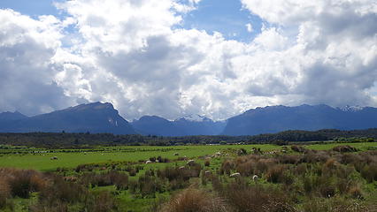
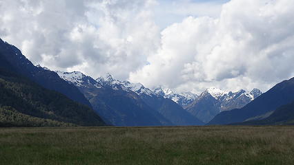
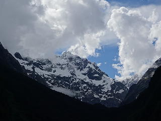
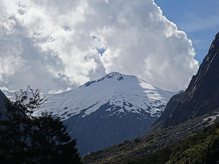
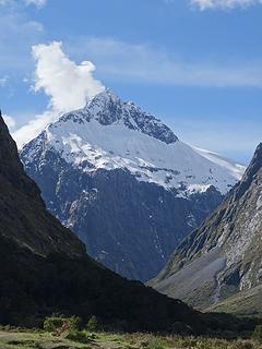
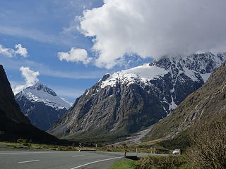
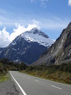
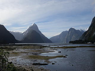
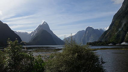
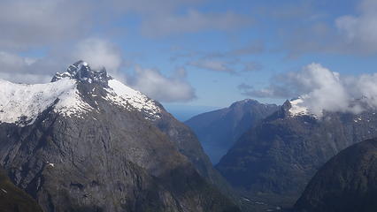
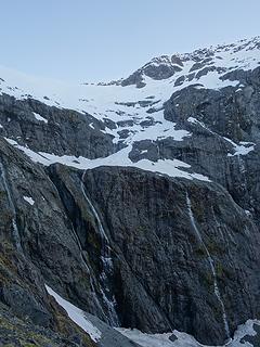
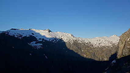
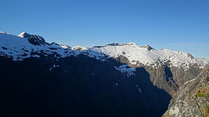
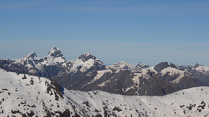
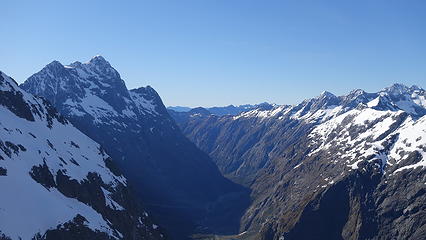
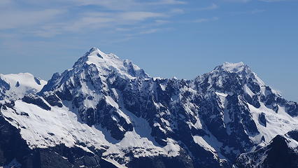
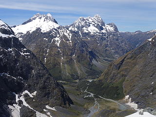
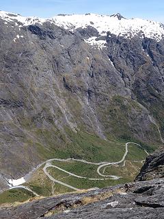
Arriving in New Zealand about a week ago, I lucked out with a few decent weather days (but not good enough for Mount Cook), so I drove down to Milford Sound from Queenstown, and explored some of the sights along the way. The drive to Milford sound is downright stunning, as the road curves around the base of the massive Mount Christina, rising over 6500 feet above the road. I checked out the overlook at Milford Sound for a bit and took in the beauty of Mitre Peak (which I hope to also climb on this trip) and found myself at the Homer Hut for the night. I agreed to join Allison, who is also from Seattle for a hike to Gertrude Saddle on the following morning (Monday Nov 11th). Forecast called for a decent morning, and an excellent day all day Tuesday, however the afternoon we rolled in it had cleared out and we saw dozens of avalanches sliding off all the high peas as the fresh snow sloughed off right when the sun came out, particularly off Barrier Peak which was nearly constant.

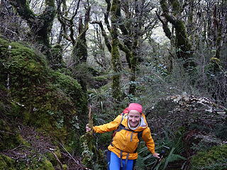
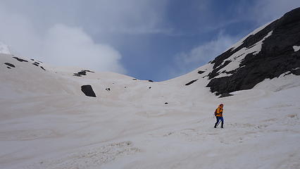
By about 6:30am we started walking on the trail towards Gertrude Saddle, but quickly discovered the trail was completely flooded for the quarter mile or so due to early season spring runoff so instead of crossing the creek we decided to stay on the left side and bypass the initial section of trail by bushwhacking through the New Zealand forest, meeting back with the trail a bit higher up where it ascends the open grassy valley away from the creek. Much to my amazement, there was no flowing water higher up in the valley since it was all flowing underground!

Views from the road to Milford Sound
Southland Mountains
Southland Mountains
 
 
Looking up at Mount Christina from the road
Mount Talbot from the road
Talbot (left) and the slopes of Crosscut (right)
 
Barrier Peak from the Homer Hut parking area
Mitre Peak from the Milford Sound viewpoint


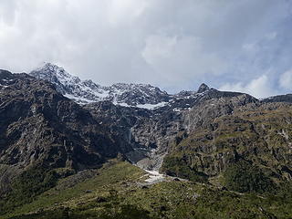
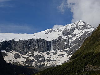
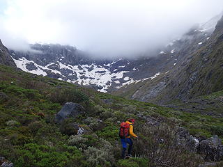
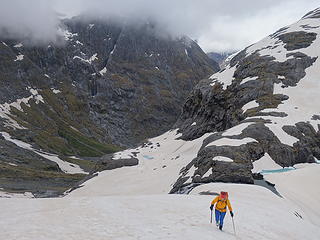
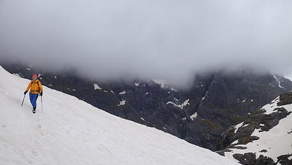
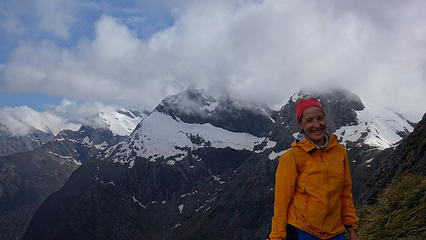
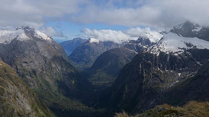
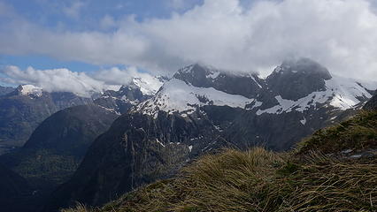
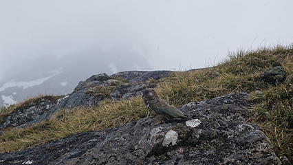
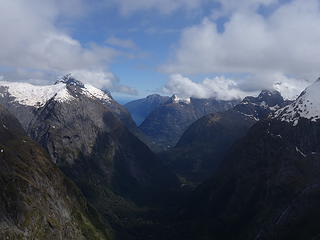
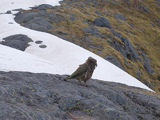
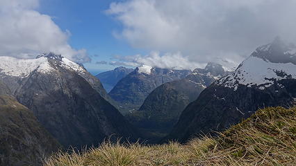
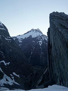
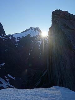
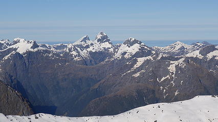
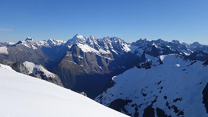
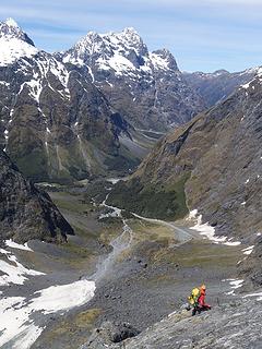
We continued on the well marked path towards Gertrude Saddle as it curved up and left around the east side of Mount Talbot. Clouds lingered and blocked views to the summits but it was not raining. We arrived at Black Lake, which was still mostly frozen and covered with snow, and the remainder of the route to the saddle was completely covered in slushy snow. Once we arrived at the saddle though it was a view for the ages off to the west with Milford Sound visible and the valley below us sweeping steeply down. The north face of Mount Talbot rose above us to the left with the giant Mount Tutoko visible to the north. There were a few Kea (the worlds only alpine parrot) flying around above us trying to get our attention...likely because they wanted to eat our food. We did not fall for the one dancing in front of us though and guarded our packs!

Bushwhacking at the start


Nearing Black Lake
Nearing Black Lake
 
 
View west from Gertrude Saddle
 
 
A Kea
A Kea
 
Kea trying to distract us
 
Mount Talbot in the clouds above


We got rained on as we returned to Homer Hut and bushwhacking a different route on the way back only made the wetness worse. Some huge avalanches fell off the steep east face of Talbot just as we were hiking by the base, but we were far enough away from the base where it wasn't a concern. The rumbling was very loud though. Eventually we stumbled out of threes back at the hut and dried off inside. Allison decided to take off for a hike further east for the following day while I stayed in the hut completely alone the majority of the afternoon as the rain set in. I took a long nap until a guided party of 6 rolled in waking me up. Turns out they were going to go up the same route I was planning to do for the next day, via Jacobs Ladder (South Ridge of McPherson) from Homer Saddle. I was however planning to also traverse to Mount Talbot. I had some nice chats with them during dinner and went to sleep.

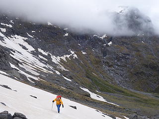
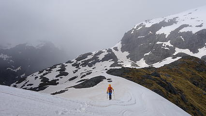
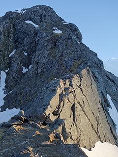
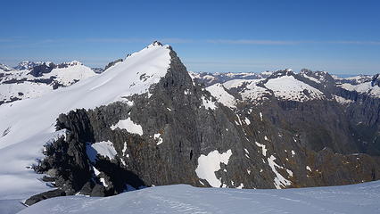
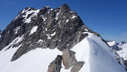
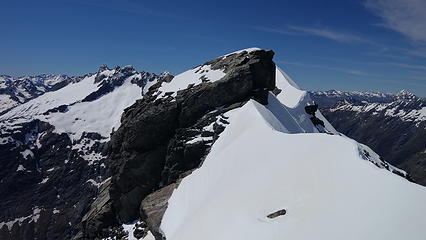
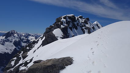
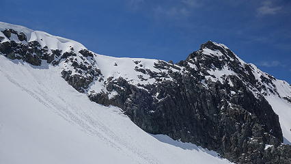
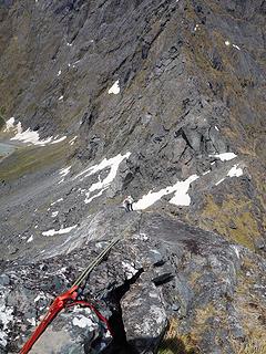
5am came and I quickly packed up and drove a couple miles up the road to the Homer Tunnel car park and waited a bit for enough light for me to start hiking without a headlight. Paty of 6 arrived and I decided to jump start to remain out ahead of them, however that proved very easy to do. The route up to the Homer Saddle was via a decent trail, with a small snowfield to ascend near the top. It was very firm so I put the microspikes on. Then the class 3 and 4 scrambling north up the rocky ridge began which was heaps of fun. The rock was nice and dry and offered great exposed climbing. Above this the terrain levelled out and I emerged onto the left edge of the massive snowfield on the upper slopes of McPherson. A quick jaunt on the firm snow led me directly to the summit to which views were indescribably eyegasmic!


Sunrise behind Mount Crosscut from Homer Saddle
View west from Homer Saddle
Looking up Jacobs Ladder (South ridge of McPherson) from Homer Saddle
View south from the scrambling towards the Moir Massif


Massive snowfield on upper slopes with the summit of McPherson shown
View east with Mount Christina at left
View west at many huge peaks in Fjordland
Fjordland eyegasms
Fjordland eyegasms
 
 
McPherson Summit view


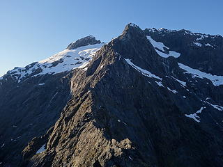
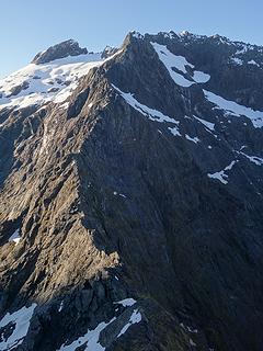
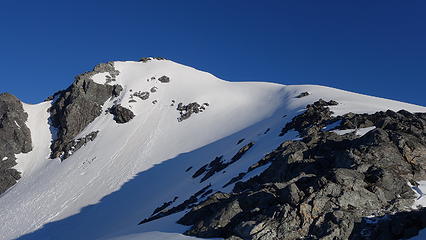
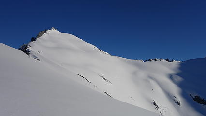
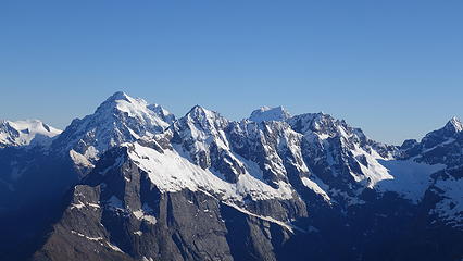
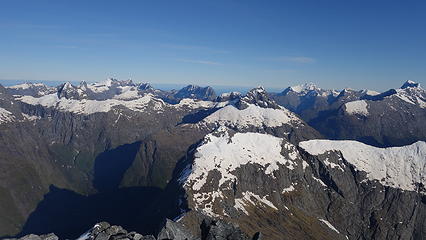
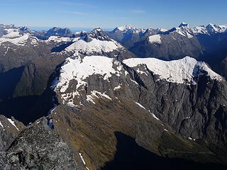
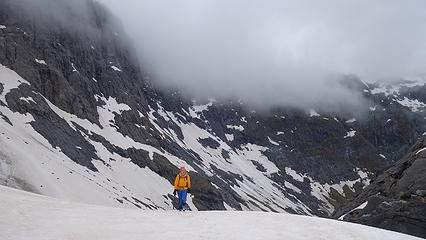
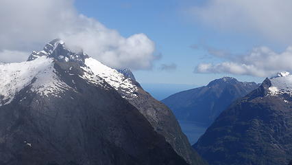
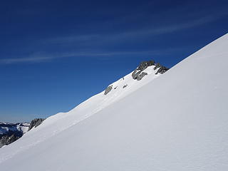
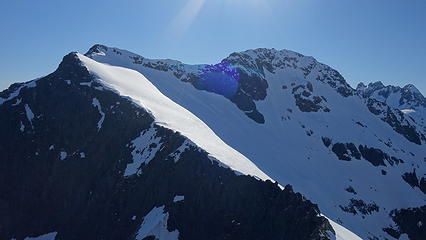
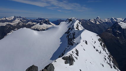
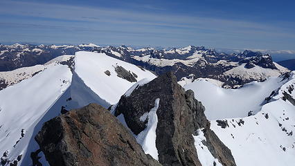
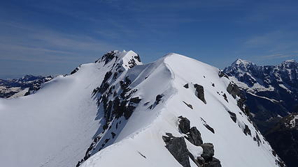
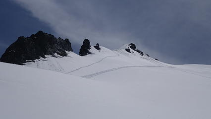
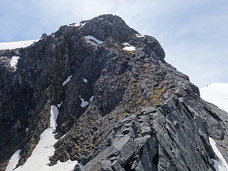
I was so far out ahead of the guided party I didn't even see them reach the upper snowfield until I had completed the traverse east all the way to the east edge of the big snowfield near the summit ridge of Mount Talbot. Initially, I topped out on the sub-peak between McPherson and Talbot but the ridgecrest was guarded by 60+ degree knife edge snow arete that made it extremely difficult to traverse without access to any rocks on either side. I didn't have big boots or crampons so I didn't feel comfortable traversing the 60 degree snow slope along the crest that also happened to be very icy and firm. So I retreated below the ride and traversed more snow slopes to the west of the ridge a couple hundred feet below the crest until I found a feasible way to ascend back to the ridge close to Traverse Pass. Since this was still on the west facing aspect, the re-ascent back to the ridge was very firm and icy snow up to about 55 degrees. Without crampons I had to bash my foot into the ice to punch through the crust on every step to give me enough of a bucket to place my feet. This was very time consuming and tiring not to mention painful on my toes and feet but I made it back to the ridgecrest closer to the summit and was able to bypass the knife edge section.

Traversing the snow towards Mount Talbot
 
Mount Talbot seen from the traverse from McPherson
 
Towering Mount Christina looms high
Looking back at McPherson
 
Ridgecrest to Talbot and knife edge snow
View of Talbot from ridge after bypassing knifey section of ridge


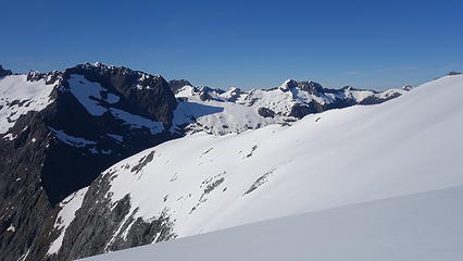
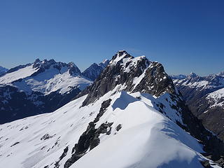
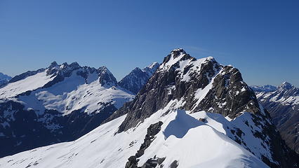
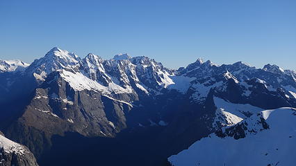
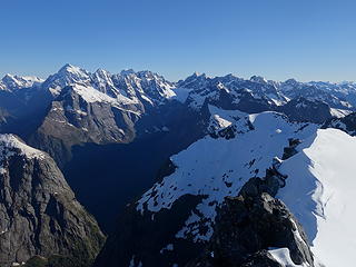
The rest of the route up the northwest ridge to the summit was longer than expected due to so much class 3 scrambling most of which was snow covered but I eventually reached the summit and enjoyed the hard earned views. I refueled with a Gu pack and retraced my steps back down, this time being much quicker since I had already bashed the footholds the whole way up.

Looking down the NW ridge of Talbot
Nearing the summit, with this rocky perch being the final obstacle
 
 
Some big mountain (Tutoko maybe) seen from the summit of Talbot
Looking back along the ridge on descent
 
Mount Talbot summit ridge...much harder when snowy
Look closely and you'll see my steps weaving up the steep slopes through the rock band to the ridge
Milford Sound road and Mount Christina
Traversing back across the large snowfield


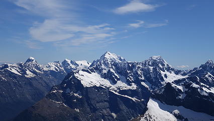
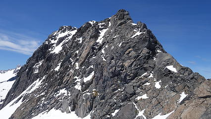
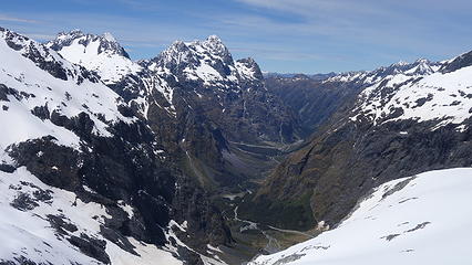
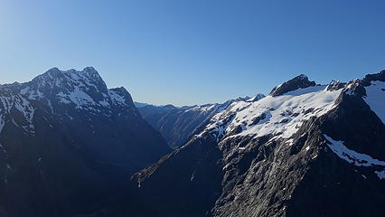
I re-traversed all the way back across the huge snowfield except this time it had softened up enough for me to post-hole past my ankles on every step making the traverse a little slower, luckily though I was able to make a downward traverse the whole way across. Just as I reached the top of the rock scrambling I caught back up with the guided group, who were on their way down from McPherson (they did not traverse to Talbot). I passed them on the downclimb as they were all rappelling and made it back to the car at 2:30pm and took a nap. The afternoon remained gorgeous and I admired the Patagonia esque views and all the steep rugged faces that surrounded me before starting the drive back to Te Anau.


Looking back at the fun rock scramble
Milford Sound road below
View of Lake Te Anau from the drive back


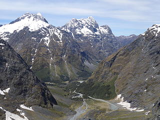
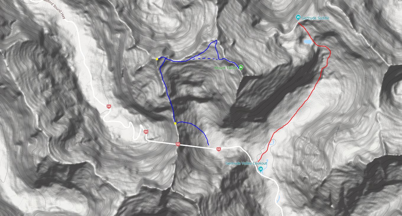
Shown below is a map of the route I took. The road clearly shows the location of the Homer Tunnel and the first yellow dot is the Homer Saddle. Second Yellow dot is the summit of McPherson with Talbot labelled. Red line shows the hike up to Gertrude Saddle.

Picture
Proudly powered by Weebly