LEMKE CLIMBS
  • About
    • Whats New
    • 2019 Goals/Wishlist
    • Contact
  • Washington
    • North Cascades >
      • Sahale Peak, Boston Peak
      • Eldorado Peak, Klawatti Peak
      • Black Peak
      • Forbidden Peak West Ridge
      • Primus Peak Attempt
      • Big Snagtooth
      • Liberty Bell Beckey Route
      • Burgundy Spire North Face 5.8
      • Ragged Ridge - Katsuk, Kimtah and Cosho Peaks
      • Colfax Peak
      • South Early Winters Spire via SW Buttress
      • Chilliwack Mini-Slam
      • Mesahchie Peak
      • Inspiration Traverse
      • Mount Shuksan Ski
      • Full Pickets Traverse
      • Mount Goode NE Buttress & Storm King
      • Mount Baker North Ridge WI3
      • Snowfield Peak
      • Lincoln Peak
      • Silver Star Mountain
      • Mount Buckner & Horseshoe Peak
      • Azurite Peak
      • Tower Mountain & Golden Horn
      • Mount Logan
      • Custer Ridge & Easy Mox
      • Mazama Dome
      • Sherman Peak
      • Mount Ballard
      • Southern Pickets Traverse
      • Corteo Peak
    • Glacier Peak Wilderness >
      • Buck Creek Pass, Cloudy Peak, Spider Gap
      • Dome Peak, Spire Point
      • Mt. Maude and Seven Fingered Jack
      • Mount Formidable NE Face 5.6 Second Ascent
      • Dumbell and Greenwood Mountains
      • Glacier Peak Wilderness Mountain Massacre
      • Clark and Luahna Peaks
      • Sinister Peak
      • Chiwawa Mountain
      • Tupshin & Devore Peaks
      • Buck & Fortress Mountains
      • Glacier Peak
    • Olympic Peninsula >
      • Buckhorn Mountain
      • Flapjack Lakes Hike
      • Grey Wolf Peak, High Divide Trail
      • Mount Ellinor
      • Mount Constance West Arete
      • Mount Olympus
    • Alpine Lakes Wilderness >
      • Chikamin Peak
      • PCT - Snoqualmie to Pete Lake
      • Foss Lakes Hike
      • Necklace and Tank Lakes
      • Enchantments Day Hike
      • Granite Mountain (Snoqualmie)
      • Colchuck Peak
      • Cannon, Enchantment and Stuart
      • Ingalls Peaks
      • McClellan Peak
      • Dragontail Peak
      • Web Mountain
      • Mount Index Attempt
      • Snow Creek Wall Orbit 5.8+
      • The Tooth South Face
      • Eightmile Mountain
      • Argonaut Peak NE Couloir
      • Little Annapurna South Face 5.5
      • Snow Creek Wall Outer Space 5.9
      • Cashmere Mountain
      • Sherpa Peak North Ridge 5.8
      • Chair Peak NE Ridge
      • Lichtenburg Mountain
      • Mount Index
      • McClellan Butte
      • Chimney Rock
      • Alpine Lakes High Route
    • Pasayten Wilderness >
      • The Craggies
      • Tiffany Mountain
      • Pasayten Mini-Slam
      • Remmel Group
      • Jack Mountain
      • Robinson Mountain
      • Monument Peak Group
    • Mountain Loop Highway >
      • Vesper Peak
      • Mount Dickerman
      • Sloan Peak West Face 5.8
      • Mount Forgotten
      • Whitehorse Mountain
      • Gothic Peak
    • Lake Chelan Sawtooth Wilderness >
      • Star, Courtney, and Grey Peaks
      • Hoodoo Peak and Raven Ridge
      • Abernathy Peak
      • Mount Bigelow
      • Reynolds Peak
      • Oval Peak
      • Gardner Peaks
      • Chelan Sawtooth Trio
    • Southern WA >
      • Mount Adams
      • Mount Rainier - Emmons Route
      • Mount Saint Helens
      • Goat Peak
      • Lane Peak, Plummer Peak (Tatoosh)
      • The Unicorn (Tatoosh)
      • Little Tahoma
    • WA Rock and Ice Cragging >
      • Index Town Walls
      • Vantage
      • Mount Erie
      • Exit 38
      • Leavenworth
  • Colorado
    • San Juan Mountains >
      • Mount Sneffels Lavender Snow Climb
      • Uncompahgre, Matterhorn Peaks
      • Redcloud, Sunshine Peaks
      • San Luis Peak
      • Vermilion, Fuller Peaks
      • Stewart Peak, Baldy Alto
      • Jones, Niagara, American Peaks
      • Wetterhorn Peak, Handies Peak
      • Wilson Group
      • Arrow Peak
      • Mount Sneffels SW Ridge
      • Jagged Mountain, Chicago Basin
      • Teakettle Mountain
      • Dallas Peak
      • Vestal Peak Wham Ridge, Greystone Peak
      • Organ Mountain
      • Phoenix Peak
      • Half Peak
      • Point 13832 Group
      • Golden Horn
    • Elk Mountains >
      • Four Pass Loop
      • Castle, Conundrum Peaks
      • Snowmass Mountain
      • Cathedral Peak
      • South Maroon Peak
      • The Pyramids
      • North Maroon Peak, Sleeping Sexton
      • Capitol Peak, Mount Daly
      • Malemute Peak
      • Hagerman Peak
    • Sangre de Cristo Mountains >
      • Blanca Peak, Ellingwood Point
      • Challenger Point
      • Mount Adams
      • Spread Eagle Peak
      • Humboldt, Obstruction, Columbia Peaks
      • Mount Lindsey, Huerfano Peak
      • Little Bear Peak
      • Crestone Needle Ellingwood Arete
      • California Peak
      • Crestone Peak North Buttress
      • Operation Dark Snake
      • Kit Carson Mountain
    • Sawatch Mountains >
      • Iowa Peak
      • Point 13,618 - Hunky Dory Lake
      • Gold Dust Peak, Notch Mountain
      • Mount Jackson
      • Mount Belford
      • Shavano, Tabeguache Peaks
      • Mount Antero, Cronin Peak
      • Twining Peak
      • Mount Massive
      • Casco Peak
      • Mount Huron
      • Mount Elbert
      • Mount Oxford
      • Mount Hope
      • Mount Yale
      • Lackawanna Peak
      • Mount Columbia
      • La Plata Peak
      • Rinker and Twin Peaks
      • Bull Hill, Mount Princeton
      • Missouri Mountain
      • Mount Oklahoma
      • French Mountain
      • Mount Ouray
      • Grizzly A, Garfield Peaks
      • Mount Harvard
      • The Three Apostles
      • Emerald Peak
      • Holy Cross
    • Greater Park Range >
      • Kneeknocker Pass, Piney Lake
      • Drift Peak
      • Sherman Peak, Dyer Peak
      • Gore Range Traverse
      • Quandary Peak
      • Pacific, Atlantic Peaks
      • Clark Peak
      • Crystal Peak, Peak 10
      • Fletcher Mountain
      • The DeCaLiBron
      • Loveland Mountain
      • The Mosquito Traverse
      • Mount Arkansas
      • Clinton Group
      • Eagles Nest, Peak C
      • North Star Mountain
      • Peak X
      • Wheeler Mountain
    • Front Range >
      • Mount Evans, Spalding
      • Mount Bierstadt
      • Mount Parnassus, Bard Peak
      • Cupid, Sniktau, Grizzly D Peaks
      • James Peak
      • Mount Silverheels
      • Grays and Torreys Peaks
      • Mount Edwards
      • Mount Flora, Longs Peak
      • Square Top Mountain
      • Petit Grepon South Face 5.8
      • Mount Meeker Dreamweaver Couloir
      • Santa Fe Peak
      • The Citadel & Pettingell
    • Colorado Ice Climbing >
      • Lincoln Ice Falls
      • Ouray Ice Park
      • Avocado Gully and The Drool
      • Hidden Falls
    • Colorado Rock Climbing >
      • Eldorado Canyon
      • The Flatirons
      • North Table Mountain
      • Shelf Road
      • Colorado National Monument >
        • Independence Monument
  • Wyoming
    • Wind River Mountains >
      • Gone With the Winds
      • Union Peak - Solar Eclipse
      • Wind River Peak
      • Wind River Slam
    • Teton Range >
      • Grand Teton Owen Spalding 5.4
      • Mount Owen Attempt
    • Wyoming Absarokas and Gros Ventre Range >
      • Jackson Peak
      • Francs Peak
    • Yellowstone National Park >
      • Top Notch Peak
    • Bighorn Range and Great Divide Basin >
      • Boars Tusk
      • Loaf Mountain
      • Cloud Peak
      • Black Tooth Mountain
    • Devils Tower
    • Cody Rock and Ice Climbing
  • Montana
    • Beartooth Mountains >
      • Whitetail Peak Group
      • Beartooth Mountain
      • Spirit Mountain Group
      • Mount Peal
      • Granite Peak Group
      • Castle Rock Group
      • Castle Mountain NE Couloir
      • Mount Inabnit and Sylvan Peak
      • Mount Hague South Slopes
      • Mount Villard and The Granite Peaks Traverse - 5.4
      • Spirit Mountain NE Ridge - 5.4
      • California Ice WI 4
      • The Ramp 5.8
      • Linea Alba 5.10d
      • Iceberg Peak
      • Metcalf Mountain North Rib 5.8
      • Villard Spires HP West Ramp
      • Cairn Mountain
      • Snowbank Mountain
      • Mount Wood Group
      • Bears Tooth
      • Glacier Peak Catch-a-Sunrise FA
    • Montana Absarokas & Gallatin Range >
      • Black Mountain
    • Southwest Montana Ranges >
      • Sacajawea Peak
      • Arrow Peak
      • Koch Peak
      • Saddle Peak
      • Baldy Mountain
      • Sphinx Mountain
    • Glacier National Park >
      • A Taste of Glacier National Park
      • Divide Mountain
    • MT Rock and Ice Climbing
  • Utah
    • Uinta Mountains >
      • Kings-Emmons Ridge Run
      • Hayden Peak
      • Iron Hayden Wall Rock Climbing
    • Wasatch Range >
      • The Sundial Eleventh Hour 5.8
      • Mount Timpanogos
    • San Rafael Swell >
      • Ramp, Cistern Canyons
      • Salt Wash, Black Mountain, Moroni Slopes
      • Ding, Dang Canyons
      • Little Wild Horse, Bell Canyons
      • Quandary Canyon
      • San Rafael Knob
      • Miners Hollow (Knotted Rope Canyon)
      • Temple Mountain
      • Chimney Rock
      • Bottleneck Mesa
      • Window Blind Peak
      • Lower Baptist Draw & Upper Chute Canyon
    • Capitol Reef National Park >
      • Cathedral Valley Tour
      • Sheets Gulch
      • Halls Creek Narrows
      • Brimhall Canyon and Strike Valley Overlook
      • George Benchmark
    • Moab Area, Canyonlands, Arches >
      • Maze District
      • Needles District
      • Maze District
      • White Rim Trail Biking
      • Elephant Butte, Bullwinkle Tower and Lizard Rock
      • South Six Shooter
      • Elephant Canyon
      • Parriott Mesa
      • Ancient Art
      • Castleton Tower North Chimney 5.8
      • Klondike Bluffs
      • Mount Peale & Tukuhnikivatz
    • Robbers Roost Country >
      • Horseshoe Canyon, Goblin Valley
      • Bluejohn Canyon
      • Happy Canyon Narrows
      • Shenanigans, Leprechaun Slots
      • Larry Canyon
      • Merry Piglet Slot
      • Lower Maidenwater Canyon, Turkey Knob
      • Morocco Canyon
      • Monkey Business Slot
      • Hog Canyon Slots
      • Upper Maidenwater Canyon Slots
      • Mount Ellen
      • Buck Canyon
      • Point 4906
      • Alcatraz Canyon
      • Hard Day Harvey Slot
      • Mount Ellsworth
      • Good Day Jim Canyon
      • White Roost Canyon
      • Upper Stair Canyon
    • Escalante National Monument >
      • Phipps Canyon and Arch
      • Red Breaks Slot
      • Dry Fork Slots, Coyote Gulch
      • Little Death Hollow/Wolverine Canyons
      • Egypt 3 Slot
      • Egypt 1 Canyon
    • Zion/Bryce >
      • Ataxia Tower Ashtar Command 5.9
      • Mount Kinesava Cowboy Ridge
      • Birch Hollow
      • Aires Butte
      • West Temple
      • Mystery Canyon
      • Crazy Streak
    • Cedar Mesa Region/Valley of the Gods >
      • Eagle Plume Tower Eagle Feather 5.10b
  • California
    • High Sierras, Southern CA Ranges >
      • Telescope Peak, Manly Beacon
      • Tahquitz Rock Whodunit 5.9 - June 2016
      • Tahquitz Rock Long Route 5.9 - July 2016
      • Palisade Traverse
      • White Mountain
    • Yosemite National Park, Central CA
    • Northern CA Cascades >
      • Lava Beds National Monument - August 2015
  • Oregon
    • Oregon Volcanoes >
      • Three Fingered Jack
      • Mount Scott
    • Blue Mountains >
      • Twin Peaks
    • Trout Creek Rock Climbing
  • Alaska
    • Eagle Peak and Mount Ewe
    • Jatt Peak and Portage Pass
    • Rainbow Peak
    • Mount Brooks Attempt
    • Arrigetch Peaks Trek
    • Ab Mountain Hike
    • South Suicide Peak
    • Mount Hunter West Ridge Attempt
    • Cantata Peak Attempt
    • East Twin Peak
    • Mount Alice
    • Crow Pass and Hope Point Hikes
    • Indianhouse Mountain Attempt
    • Lynx Peak
    • Harding Icefield Hike
    • Hatcher Pass and Grapefruit Rocks Climbing
    • Mount Sanford
    • Mount Hunter West Ridge
  • Nevada
    • Ginger Cracks 5.8
    • Mescalito Dark Shadows 5.8
    • Birdland and Olive Oil
    • Frogland 5.8
    • Johnny Vegas 5.8
    • Schaeffer's Delight & Triassic Sands
    • Solar Slab - 5.6
  • British Columbia
    • Mount Matier
    • Taiya Peak
    • Bugaboo Spire NE Ridge
    • Mount Sabine Easy Honey 5.10b
    • Mount Sir Donald NW Ridge Attempt
    • Black Tusk
    • Squamish Ticks
    • Slesse Mountain NE Buttress
  • Alberta
    • Mist Ridge Hike
    • Mount Temple Attempt
    • East Wendell Peak
    • Loder Peak
    • Tower Mountain Attempt
    • The Rimwall
    • Mount Yamnuska Directissima 5.9
    • Mount Lawrence Grassi
    • Mount Lorette
    • Roche A Perdrix
    • Mount Edith Cavell East Ridge 5.3
    • Mount Louis Kain Route
    • Eiffel Peak
    • Canadian Rockies Ice Climbing
  • Other States
    • Arizona >
      • Grand Canyon Bright Angel Trail
      • Beanfest at Cochise Stronghold
      • Baboquivari Peak
      • Humphreys Peak
    • New Mexico >
      • Philmont Trek August 2008
    • Yukon >
      • Canyon Peak
  • International
    • Mexico & Central America >
      • Mexico - Pico de Orizaba, Izta - March 2012
      • Guatemala Volcanoes
    • South America >
      • An Introduction to Patagonia
      • Cordillera Blanca - Tocllaraju and Urus
      • Nahuel Huapi National Park & The Frey
      • Exploring Pucon and Lanin Volcano
      • Cordillera Blanca - Ishinca Peak and Artesonraju
      • Cordillera Blanca - Quitaraju & Alpamayo
      • Exploring Southern Peru
      • Cerro Helio Azul & Tronador Attempt
      • Aguja Guillaumet Amy Couloir
      • Cerro Puntado & Palo
      • Cerro Colorado
      • Cerro Puno & Agudo
      • Cerro Trinidad Attempt
      • Volcan Quetrupillan
      • Cerro Placas
      • Nevado de Acay
      • Pequeno Alpamayo
      • Huayna Potosi
      • Illimani
      • Chiaro de Luna
    • Oceania >
      • Exploring New Zealand's South Island
      • Puncak Jaya
      • Mount McPherson and Talbot
      • Single Cone
      • Mount Cook
      • Mount Aspiring
      • Manakau
    • Central Asia >
      • Kyrgyzstan 2021
  • Sorted by Year
    • 2008 Trip Reports
    • 2009 Trip Reports
    • 2010 Trip Reports
    • 2011 Trip Reports
    • 2012 Trip Reports
    • 2013 Trip Reports
    • 2014 Trip Reports
    • 2015 Trip Reports
    • 2016 Trip Reports
    • 2017 Trip Reports
    • 2018 Trip Reports
    • 2019 Trip Reports
    • 2020 Trip Reports
    • 2021 Trip Reports
  • Vanlife
    • Conversion Journal >
      • Floor Installation
      • Folding Bed
      • Coffee Table
      • Thinsulate Installation
      • The Couch
      • The Wardrobe
      • Bookshelf
      • Water System
      • Electrical System
      • The Pantry
      • Refrigerator
      • Tire Upgrade
      • Heating System
      • Composting Toilet
LEMKE CLIMBS

Mount cook

aoraki/mount cook - 12316' - Zurbriggen ridge - ai3 m3
november 2019

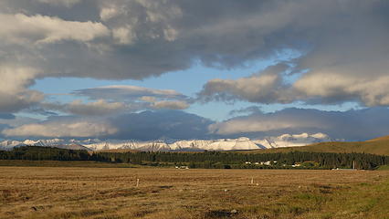
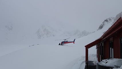
After spending a few days in Wanaka a weather window finally began to present itself after weeks of stormy weather that dumped buckets of snow on the Southern Alps. Numerous back and forth messaging to my climbing partner Graeme as he continued to push his flight to Christchurch from Auckland until we could see good weather ahead. On Monday the 18th, we agreed I would pick him up the next day and drive to Mount Cook village. I organized with the helicopter company InFlite in Mount Cook Village and arranged for us to take a helicopter transfer to the Plateau Hut on Wednesday morning as it wasn't looking like we were going to have a long enough weather window to walk in (which takes at the very least a very long day, normally two).

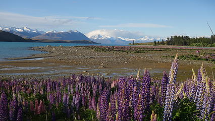
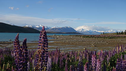
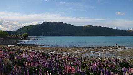
Graeme was right on time as I waited at the Christchurch airport, and we were soon off on the drive back to Mount Cook. After a quick stop at the grocery store we began discussing ideas for how we would tackle Mount Cook, while also possibly trying to climb a secondary objective as well. We arrived at Lake Teakpo where I had arranged a hostel for us to stay the night. We had burgers next door and enjoyed a few beers, and came upon the idea that we could fly into the Plateau Hut (which is the newly built 33 bunk shelter at 2200 meters at the foot of Mounts Cook and Tasman), then climb Cook right away. We could then utilize a second weather window coming in the following Monday/Tuesday to walk down to the Tasman Glacier via Haast Ridge then try for Malte Brum, then hiking the whole way back to the village. This was very ambitious, and due to both weather and conditions we were only able to climb Cook, but the idea was fun nonetheless!

Southern Alps clearing from storms
Lupines indicate springtime in New Zealand!
Evening at Lake Teakpo
Doesn't look like spring in the mountains...
Tons of snow in the high peaks
Road to Mount Cook village along Lake Pukaki


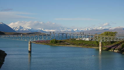
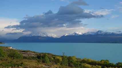
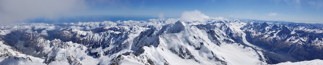
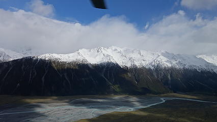
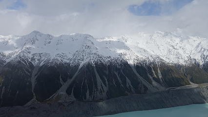
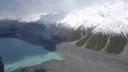
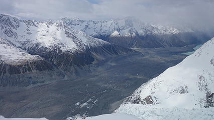
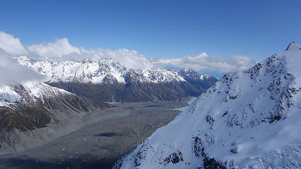
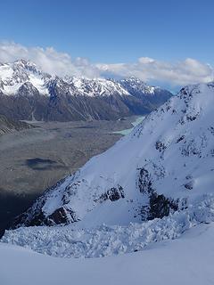
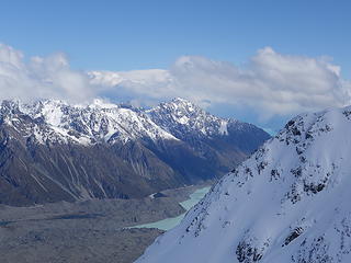
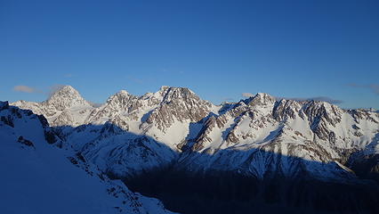
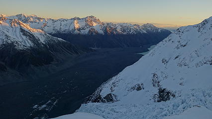
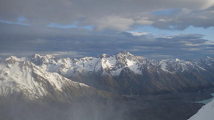
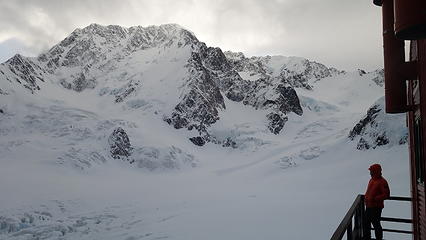
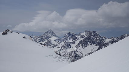
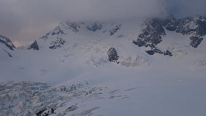
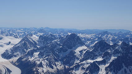
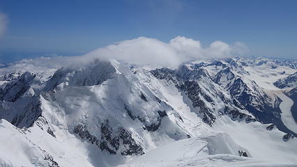
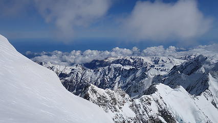
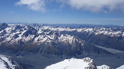
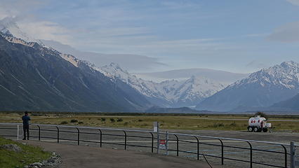
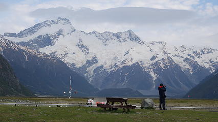
So when morning came on Wednesday the 20th, we had a buffet breakfast at the hotel in the village to celebrate our last real meal for at least a week. At 9:30 am we were loaded into the helicopter and our ride from the Cook airport at 700 meters elevation to the Plateau Hut at 2200 meters elevation began. The chopper ride only cost us $350 NZ dollars (about 200 USD) per person for the 15 minute ride up...cheap! Looking down on the Tasman Glacier, and the lake at its terminus was inspiring, but I knew how fast this long glacier is receding. At least 300 meters of the ice calves off into the ever growing lake each year. The recent storms had dumped literally meters of snowfall over the past couple weeks, and above about 1700 meters the mountains were completely decked in snow. An eerie ambiance filled the southern alps as the highest peaks were shrouded in clouds. The chopper made the final ascent up the Hochstetter icefall that descends from the Grand Plateau and we quickly honed in on the hut and landed.

Without turning the chopper off, ourselves and our gear were offloaded and the pilot made a sweeping right turn down the mountain and was out of sight, all within a minute from when we landed. We went from complete civilization with springtime greens and warm temperatures, to nearly alone on the slopes of the highest mountain in New Zealand in a landscape totally white and devoid of any life. The hut, only a couple minutes walk away would be our home for the time being, which proved invaluable due to the hurricane force winds that we would endure for the next week. Despite only being a 50 meter walk from where we landed to the hut, all the recent snow had us sinking past our knees as we hauled our stuff inside, and to our surprise we saw two others inside; Brad (who is from Colorado) and Andreas (from Norway). We would end up befriending these two climbers (also on the mountain independently) and get to know one another well over the next week.

Taking off in the chopper from the airport
Distinct snowline
Distinct snowline
 
The southern alps
A concerning amount of snow
 
Tasman Lake below at the terminus of the rock strewn Tasman Glacier


Looking down the Tasman Glacier from the hut
View across the Tasman Glacier valley towards Malte Brum (peak at left)
Another chopper offloading more climbers
Andreas enjoys a brief moment of sun near the hut
Myself exploring the area around the hut


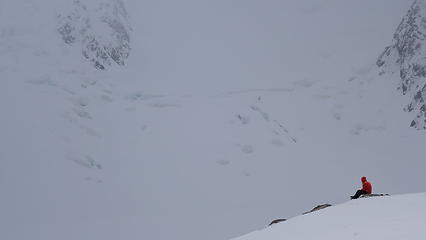
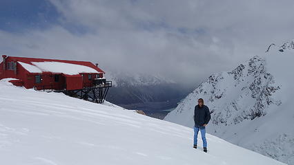
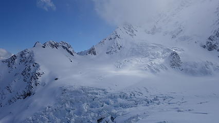
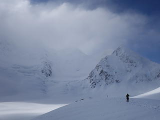
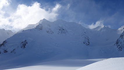
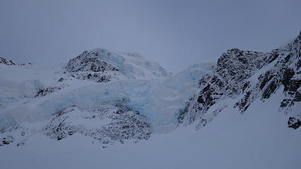
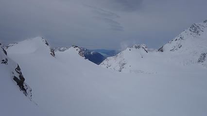
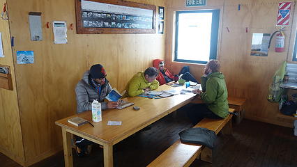
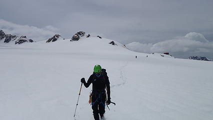
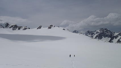
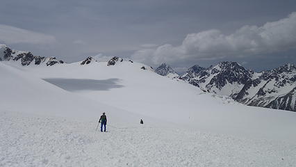
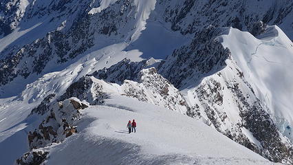
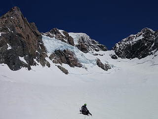
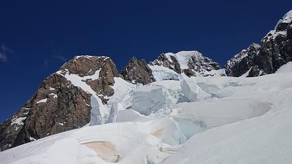
It was clear now how much snow actually had fallen just in the previous week alone. Over 2 meters had fallen and this made me quite worried as to whether the routes on Cook would ever consolidate for the snow to ever provide enough support underfoot as to not wallow around which would take triple the time to climb. The four of us decided to make a recon mission onto the plateau to try and break a trail across towards the start of the Zurbriggen Ridge, which we were initially hoping to climb the next day. Brad and Andreas, initially hoping to climb the east ridge decided after seeing the conditions they would join us for Zurbriggen. So off we went, in a complete whiteout as the snow continued to come down trying to walk in a straight line towards Mount Cook across the 1 mile wide plateau. We however didn't get very far (perhaps 400 meters) before turning back. We were sinking to our knees on every step and we realized that no one could feasibly climb Mount Cook the following day as here was just too much snow. I was worried, but I did know this is maritime snow and once even just one warm sunny day comes around, it should consolidate quickly. By mid-afternoon, a few other guided parties arrived at the hut also via helicopter and we soon had a whole posse at the hut. Inside, we explored a little more and was happy to see the hut was outfitted with gas powered stoves, a rainwater collection system for fresh water, and the burliest construction I have ever seen for a mountain hut. Knowing winds can exceed 150 MPH here it made sense, but it was wild to see the nail spacing on the support walls be just 1 inch apart, and the entire structure framework was steel beams welded together. 68 1 inch bolts held the structure to concrete pillars bored into solid bedrock. All this was done with helicopters!!

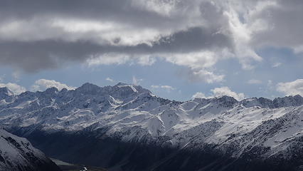
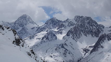
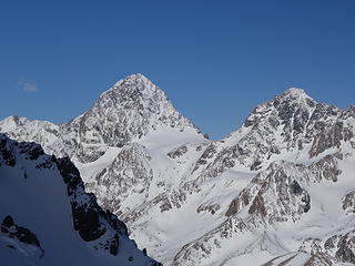
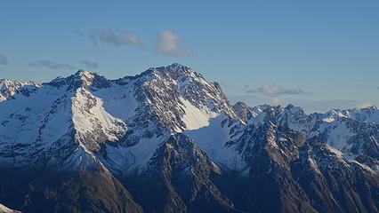
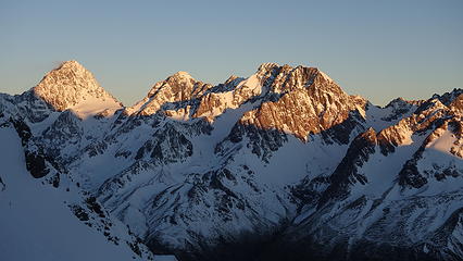
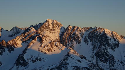
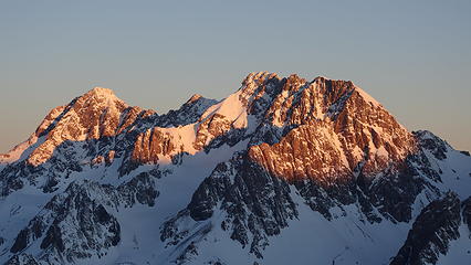
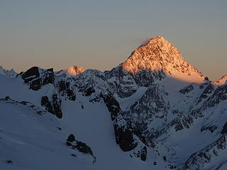
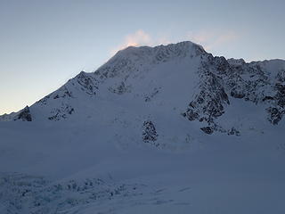
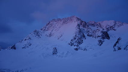
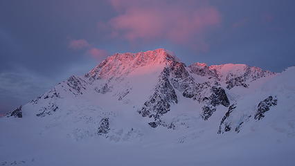
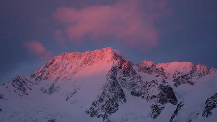
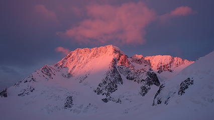
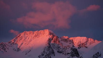
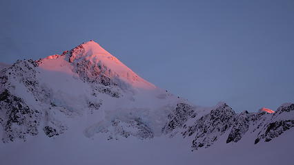
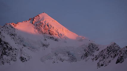
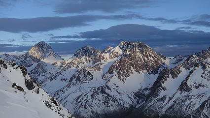
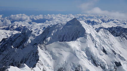
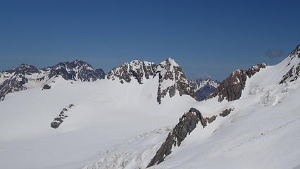
The four of us (my climbing partner Graeme, Brad and Andreas) decided we would attempt Mount Dixon, a 3000 meter elevation peak off to the north end of the Grand Plateau the following morning, since the weather called for calm and stable skies, but the conditions on Cook would not yet be ready. As the clouds slowly parted later in the afternoon, we began to slowly see more and more of Mount Cook (and Tasman next door) as they came out of hiding, invoking excitement similar to a strip tease  embarassedlaugh.gif

 
Anzac Peaks and Cinerama Col now visible at the southern end of Grand Plateau
Mount Dixon clearing out to the north
Looking down the Hochstetter icefall with Tasman Lake in the distance
Roaming around the plateau
 
Mount Cook finally fully visible!
Afternoon sun on Malte Brum
Mount Tasman now clear as well
Near total snow coverage on Mount Dixon
Mount Tasman east face


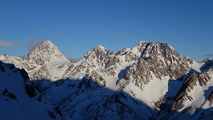
We enjoyed a calm afternoon and evening taking photos of the sunset that surrounded us. This would be the last time we had calm winds for the next 4 days. When the weather forecast was radioed in at 7pm, we were in for some serious winds (normal for New Zealand!) however mostly decent skies until Saturday night, at which point a small amount of rain was forecasted. The best weather appeared to come in on Monday the 25th, so with our plan to attempt Dixon the following day, we abandoned our plans to also try for Malte Brun, which was very far away, and put all our bets in for Monday being the day we would climb. All we could do is hope that over the next 4 days all this snow would slide off the steep mountain faces, and consolidate. Friday-Sunday we would simply wait in the hut. While at times it did get boring, we had plenty of people to chat with, play games with and discuss ideas with so it wasn't so bad. We cooked ourselves dinner that consisted of instant mac and cheese, while the guided parties that had come in that afternoon made gourmet meals suitable for a 5 star hotel! Since we were originally planning to walk out, we didn't bring lots of heavy and fresh foods, which we would regret for the rest of the trip after seeing what some of the others had brought, since weight was a non-issue.

Afternoon on the Malte Brum Peaks
 
 
Sunset over the Tasman valley
 
Sun setting behind Cook


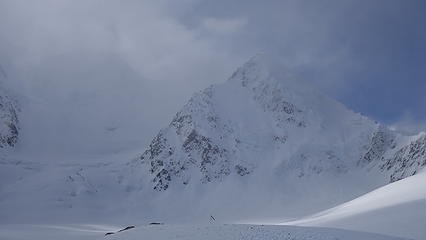
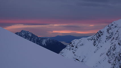
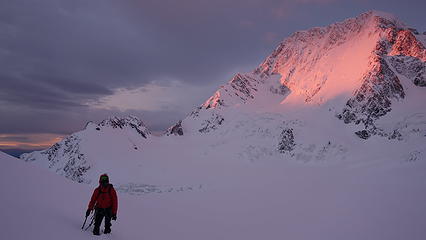
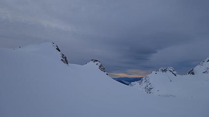
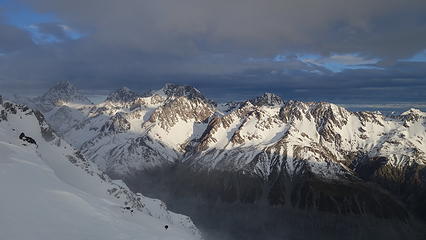
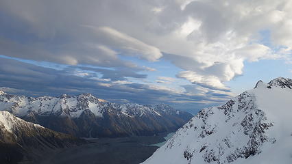
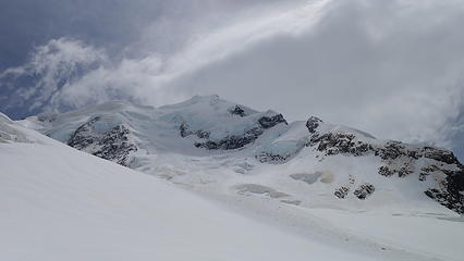
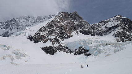
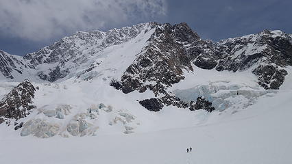
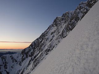
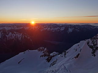
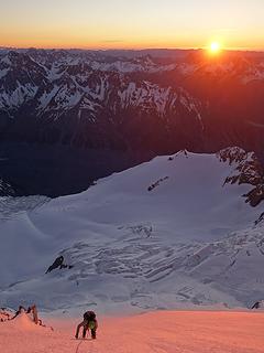
Alarms were off at 4am the following morning where Graeme and I decided we would attempt the far gully approach to the east ridge of Dixon rather than the ridge direct all the way from Glacier Dome. Exposed and difficult rock steps on the ridge between Glacier Dome and the base of the main east ridge on Dixon looked tedious, however Brad and Andreas decided to try it anyways. Graeme and I started walking north along the edge of the Grand Plateau traversing below Glacier Dome and the ridge while sinking to our knees almost constantly. It was slow going, however the sunrise was totally one for the ages that took my mind off the misery we were enduring. We eventually reached the base of the sloped apron at the base of the gully leading up to the ridge, however the wallowing got even worse here. I began quite literally tunneling my way through chest deep snow to make upward progress up the slope to the bergschrund. Graeme and I switched off, taking an hour to gain roughly 150 feet! When we reached the schrund, it was mostly covered with poorly consolidated snow and appeared about 2 meters wide, so I belayed Graeme across in a spot that looked the most stable. I followed, then took lead into the gully proper, which was much firmer than the slopes below it.

I was stoked to finally be on better snow, giving me hope that the steeper aspects of the peaks had firmer snow and ice since most of the loose stuff just rolled off during accumulation. Midway up the narrow gully however, the wind really began to pick up and we started to get bombarded by spin-drift coming off Dixon high above. With concerns of a larger slide coming down on us from somewhere, and winds increasing to hurricane force, we decided to bail and return to the hut, turning back a couple hundred feet from the ridgecrest. Shortly after we began downclimbing, we saw Brad and Andreas already walking down the slopes onto the plateau below us, having decided to bail as well due to the wicked winds that had come earlier than the forecast called for. We ended up just making a flying leap over the schrund on the way down and unfortunately the wind wiped out our tracks we made coming in, so we had to once again break trail back to the hut, even following closely behind the others, tracks in the snow would be filled within minutes from all the snow blowing around. I was hopeful that the wind would just blow it all into outer space! The final 15 minutes to the hut the winds got even stronger which made it difficult to even stand up...I couldn't imagine what it must be like on the tops of the ridges during these times.

Twilight on Cook
Breaking trail towards Mount Dixon
 
 
Sunrise over Cook
Sunrise over Cook
 
One of the best scenes I have ever seen
Sunrise on Dixon
Graeme adiring the sunrise from knee deep snow
Mount Dixon, with the gully we were ascending at lower right and the east ridge on right skyline
Icefalls on the south face of Dixon
Glacier Dome from the Grand Plateau
Wallowing up the apron below the gully
Finally entering the gully


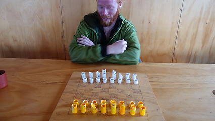
By 9am we were back at the hut and we took a nap as heavy winds battered the hut the whole day. It was a good thing we didn't try for Cook this day as we wouldn't have even gotten close. As the day went on, we played some cards, and I even found a ghetto chess board hand made with a piece of plywood and some PVC pipe! At times it was difficult to avoid boredom, however I thought back to the entire 2019 year for me, where I was on the go 100% of the time very busy with travels, work, other climbing objectives, training, and more and was thankful for the time to just sit and relax, and reflect on where we were. I was very thankful, and even more so since Thanksgiving was approaching.

Very windy conditions; notice the spindrift getting blasted down the valley
Sun rays illuminating the Malte Brum Range
 
Wondering if Cook will ever allow us a safe ascent
Stunning scenes like this were commonplace
View inside the hut with everyone trying to avoid boredom


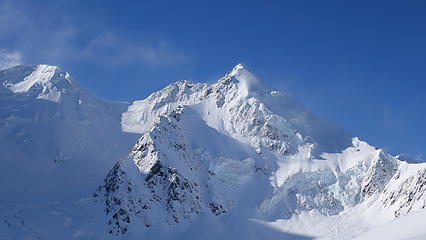
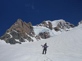
The next 3 days I didn't take too many photos as the days were spent staying in the hut, with the only exception being another recon mission across the plateau on Friday. With the temperatures warming considerably, and the sun out all day Friday, a lot of melting occurred. Despite the winds still stronger than ever, there wasn't any spin-drift on the plateau anymore. Therefore we decided to walk all the way across right to the base of the Zurbriggen Route and make a good path in the snow for us to follow on the night of our climb to reduce routefinding issues. We made out way to the left leaning ramp below a huge serac before turning back as the heat of the day was getting critical for huge avalanches and icefalls. Just as we turned back, a gigantic slide came off the east face and stopped just a couple hundred feet of where we were. We were happy to see so much snow slide off the route, as we knew that would only make the climb safer. I was amazed at how much improvement just the one warm day was making on the intense recent snowpack, and my hopes for a successful summit were growing. Back at the hut Graeme and I played a 6 hour game of chess to pass the rest of the day. Another awesome thing that happened, was that out of the blue, Alastair, an old friend I had ice climbed with in the Canadian Rockies back in 2017 happened to show up at the hut with intentions to climb Simberhorn. He is on the NZ alpine team and a very strong climber, but he remembered me right away. We chatted for a bit which was good to catch up.

Walking across the plateau
 
Nearing the base of the Linda Glacier with the ramp to Zurbriggen on the left
 
Mount Tasman from the ramp to Zurbriggen
Grand Plateau and Malte Brum in the distance
Photo taken before the big slide down the east face
Photo taken after the big slide down the east face
Ghetto chess board!
Clouds descend on Mount Cook once again


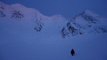
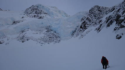
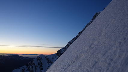
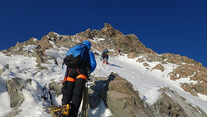
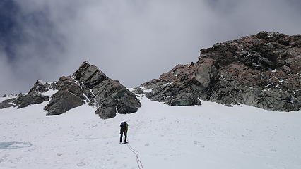
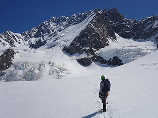
Saturday and Sunday we really didn't leave the hut at all. More and more guided parties arrived though, including a team with two badass women guides from Christchurch and their clients. They spoke highly of how the East Ridge would be an excellent climb and in great condition right now, which was enough to convince Brad and Andreas to change their objective back to the East Ridge, leaving Graeme and I alone on Zurbriggen. We also befriended two guys who came in over the weekend who were living in Brisbane, Australia, one of which had grown up in Sequim, WA! We traded stories of the Olympic Peninsula which was fun. As Sunday evening approached, there were about 20 people in the hut by this point, with everyone going for the summit leaving about midnight Monday morning. As far as I know, no one, including myself got any sleep that night, and at midnight, there was a mass exodus of the hut and onto the mountain. All the guided parties, and the two from Australia (the only other independent parties on the mountain other than us and Brad/Andreas) went for the standard Linda Glacier route. We started up the Zurbriggen, and Brad/Andreas started up the east ridge. To everyones thrill, the snow had firmed up very nicely at night and travel across the plateau was very quick and efficient. We didn't sink at all walking over!

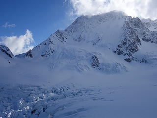
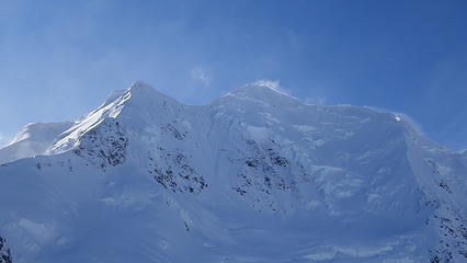
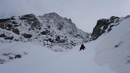
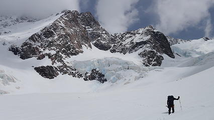
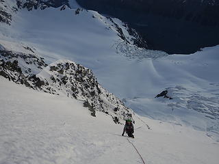
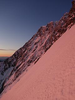
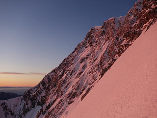
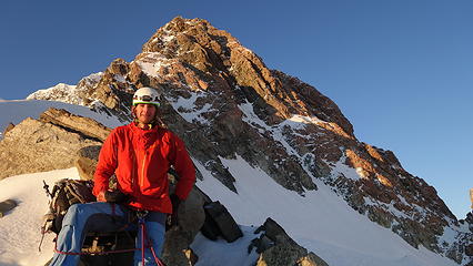
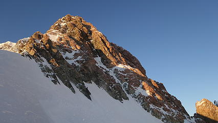
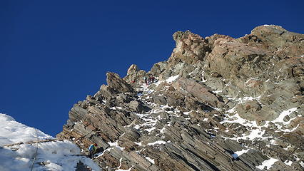
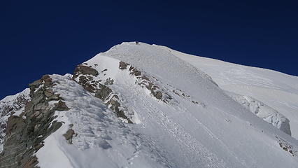
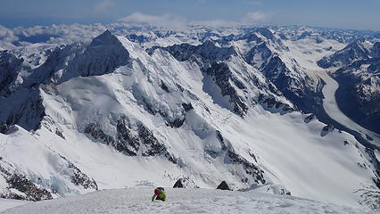
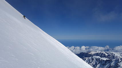
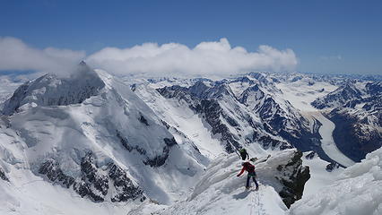
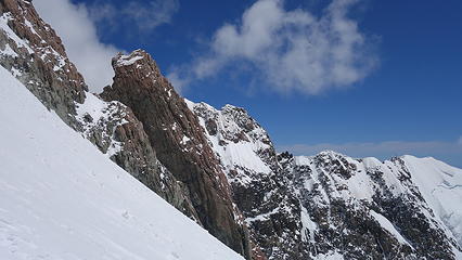
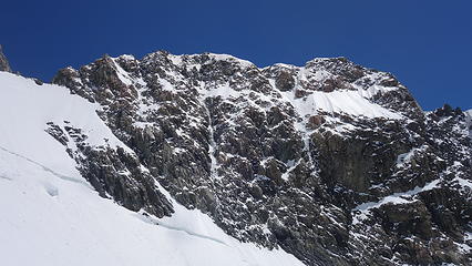
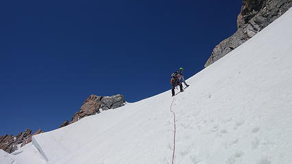
As we reached the start of the ramp, we started heading uphill, still on firm snow. We roped up and put on our crampons right at the base of the ramp. Since it was dark however, we did have some trouble routefinding a couple times, but using a photo of the face I took from the hut the previous day we were always able to re-orient ourselves and get back on track. our ascent was mainly on the right edge of the large east face of the mountain, not really climbing any of the rock on the Zurbriggen ridge at all. We rounded the corner to the right and was easily able to cross the huge bergschrund since it was largely filled with snow from the large slide. We passed by a big ice serac and started up the steepening neve ice, which was in perfect condition. Graeme and I switched off leads, simul-solo climbing the entire face which averaged about 50-55 degrees in steepness. This was definitely steeper than I had anticipated, but made the climbing more fun. Since the snow firmed up so much, it was relentless front-pointing with our crampons the entire way up the 2500 feet to the ridge where we would meet up with the standard Linda Glacier route at the summit rock pitches. Midway up the face, we entered the part with many rock outcrops poking through the snow, which proved difficult to routefind through in the dark. We ended up starting what felt like a never-ending leftward traverse, since heading straight up the ice face kept bringing us closer to the rocky ridge crest, which we didn't want to climb. We could constantly see the headlight from Brad and Andreas on the other side of the east face on the east ridge route, which they were neck and neck with us making upward progress until we lost them when twilight came.

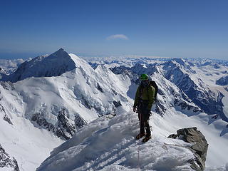
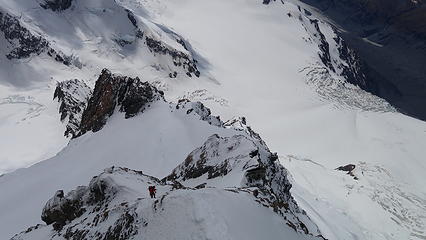
2/3 the way up the face we hit the long rock cliff that jutted way left into the face that we traversed around. A ways above this major obstacle twilight began to illuminate the mountain and we could begin to see the rest of the route up, more or less following the edge of the rocky buttresses, keeping them just to our right. The steepness was unrelenting 55 degrees bullet hard neve, and as we neared the top of the face turned into even harder alpine ice. I was out in front on this finishing section, and at the worst possible time as I am soloing up this now 60 degree ice, Graeme needed to stop to make an anchor and feed me more rope since there wasn't enough rope between us for us to both safely simul-solo this section at the top. I had to stay in position, crampons and tools in the ice with my calves burning until he could feed me more rope to pull over the last 15 feet to the ridge. Luckily the ice was bomber and great for climbing and I made it up to the top, at which point I was able to see the mass of guided parties already starting up the summit rocks. I belayed Graeme up and we took a much needed rest here before starting the next segment of the route.

Our route up Mount Cook; notice all the leftward traverses
Twilight on the Zurbriggen Ridge
Looking down the route we ascended
Upper east ridge on the far end of the face
Graeme ascending icy neve on the upper part of the face
First rays of sun
First rays of sun
 
Graeme climbing as the sun rises behind
Upper east ridge lights up at sunrise
Resting on the ridge after completing the Zurbriggen ridge
Mount Tasman across the way
 
Summit rocks lie ahead as the next segment of the climb
Looking up the summit rocks


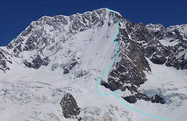
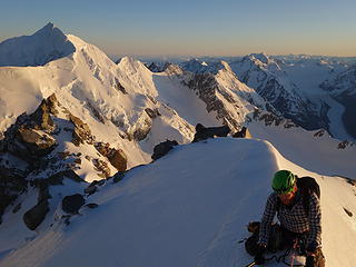
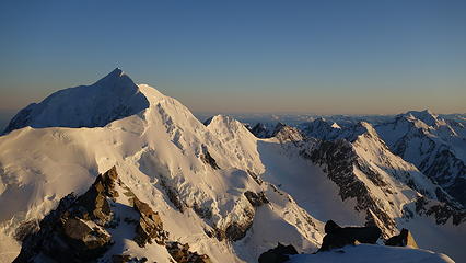
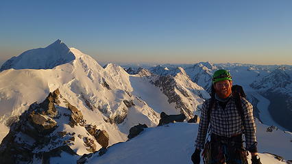
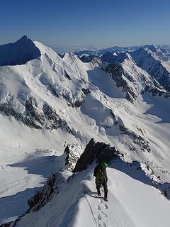
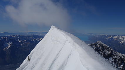
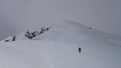
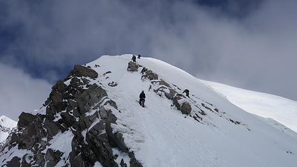
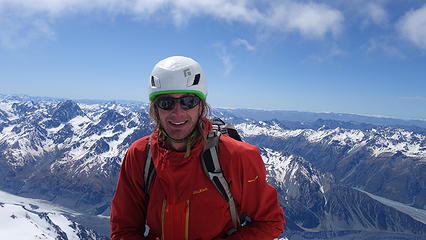
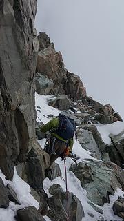
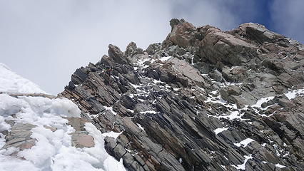
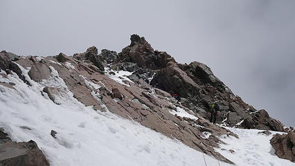
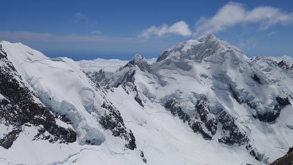
To our dismay, somehow all the guided parties beat us to the start of the summit rocks going up the Linda Glacier, so we were forced to wait a bunch going up each short pitch. We initially traversed left to the base of the rocks and started up another snow gully, however less steep than what we had climbed so we continued simul-soloing until we reached the base of the first of two crux pitches. After a 15-20 minute wait for parites to clear above, I led a 25 meter long M3 pitch on rock that looked horrendous, however was quite solid due to everything being frozen in place. Since I had to remove my gloves to climb some rock, my hands got quite cold when I reached the anchor. I was amazed to see bolted anchors on these pitches! Graeme then followed as one of the guides led the next pitch, then he took off leading a full 60 meter pitch to the top of the summit rocks at which point we unroped and completed the final 400 feet or so on the lower angle summit ice cap solo. I took off ahead and passed a few of the guided parties who were still pitching out the remaining climb on the 35 degree ice cap, and reached the summit exactly at 10am. I was elated and despite the cold wind I was so happy to be standing on top of New Zealand, after thinking about this mountain for years! Graeme rolled on top about 10 minutes later and we enjoyed some summit photos, and admired the view for a full 15 minutes before starting the trek down.

 
Starting our way up the summit rocks
Looking down Mount Cook towards the Grand Plateau
Crux pitches of the summit rocks
The long Tasman Glacier way down there
Graeme on a narrow section of ridge above the summit rocks
 
Looking up the final summit ice cap
 
 
Mellow slopes near the summit
View north from the summit
Tasman sea visible to the west!
The highest snowy point that the Maori request people avoid standing directly on top of (it's only 3 feet higher and 30 feet away)
View northeast from the summit
Other climbers nearing the summit
Mount Tasman


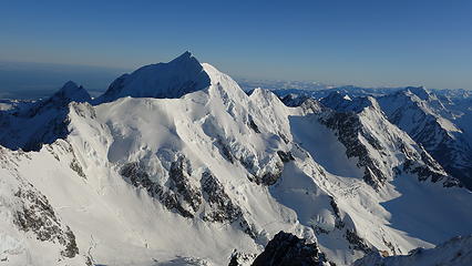
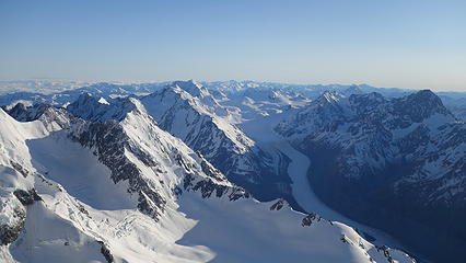
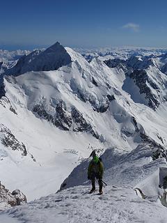
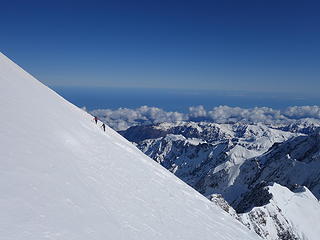
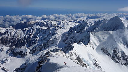
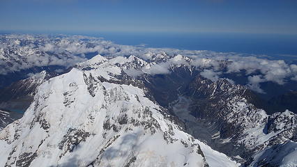
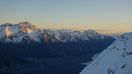
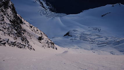
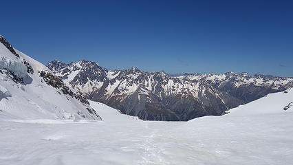
We retraced our steps down the summit ice cap back to the top of the summit rocks, thankfully passing all the guided parties in the process. We then made a series of quick single rope rappels down the numerous bolted anchors (9 total I believe) all the way down to the base of the initial gully where we met up with the Linda Glacier Route. We even used a picket just sitting at the base of the gully left by one of the guides to rappel over an obvious bergschrund just below us for extra safety. Once here, we roped back together and began traversing skiers left down the Linda shelf, which was certainly tedious due to the softening snow. There was one more party of two below us that we passed just as we completed the Linda Traverse and started down the main part of the glacier, exposing ourselves to the Gunbarrel; a massive serac zone with ice towers as big as skyscrapers on the north face of the mountain above the Linda Glacier. We tried to descend this area quickly, but by this point the snow had softened considerable, and we were sinking to our knees fairly often. I led us through the glacier safety, avoiding areas I suspected there would be hidden crevasses, since any snowbridges in this warm sun would likely not support our weight. We made slow but steady progress down the glacier, curving right and finding some fresh post-hole tracks coming down from the left from the obvious low saddle. I wondered if these were Alastair's tracks coming off from Simberhorm...we eventually reached the Grand Plateau once again at about 3pm. The final slog back across to the hut was indeed taxing but by 4pm we made it back to the hut, tired but happy. We were greeted by a large mountain rescue team who had come up for some training on the nice day.

Downclimbing the ice cap


Happy to have climbed Cook!
Graeme making one of the rappels down the mixed pitches
 
Looking down the route
View of the summit rocks
 
 
Traversing the Linda Shelf on descent
Tasman getting closer as we descend
Looking up at the Gunbarrel as we emerge into the danger zone
 
 
Graeme trying to not get stuck in the deep snow
 
Looking down the lower Linda Glacier
More seracs on the Linda
Anzac Peaks
Mount Dixon; a familiar sight
Reflecting on the route as we walk back across the plateau


We took a nap for a few hours, then waited up to ensure everyone made it back to the hut safely. At about 8:30pm, Brad and Andreas made it back from their successful climb of the east ridge, which they had some sick stories of the summit traverse! At 11pm the final two people (two guys from Brisbane) made it back. They had one hell of a day at 23 hours out! So stoked everyone made it up and around midnight, we went back to bed, just as another couple parties were waking up to attempt it on Tuesday. Unfortunately, they would not get so lucky with weather and they were already back at the hut when I woke back up at 7:30am, having turned back by increased winds and cloudier skies as the high pressure system was rapidly ending over New Zealand. With the help of one of the guides who had radio communication with the airport, everyone who had climbed the previous day was able to get on one of 4 heli shuttles back to the Mount Cook airport (16 people leaving). I was amazed at how efficient they were at flying back and forth 4 times to get everyone, and all the gear off the mountain. With the gusty winds exceeding 50 MPH I was worried they wouldn't be able to fly that day but even though the ride was bumpy, they had everyone down within a couple hours. Splitting the cost of the ride down, Graeme and I each paid NZD $240 for the ride out (about USD $150). That made our total cost round trip for both heli transfers USD $350 each. New Zealand helicopters really are the cheapest in the world! Once we were all back, the 6 of us (all who were independent on the mountain) met up for burgers and beers in the village before parting ways. I drove Graeme to Queenstown where he caught a flight back to Auckland and I crashed with a friend in Wanaka for a much needed feast, shower, and a nice rest.

Southern Alps from back at the Mount Cook airport after riding out
A tourist enjoys the view of Mount Sefton from the airport


Reflecting back on this trip, and thinking of my last trip to New Zealand back in January of 2017, I never even got a chance to leave Mount Cook Village due to an entire month of bad weather that trip. So far on this trip to New Zealand, I have been granted 3 awesome weather windows, so I am very thankful of that, and I have already made some awesome new friends. This so far has been one of the most successful climbing trips of my life, and it isn't over yet! In just a few days time I will get another weather window to attempt Mount Aspiring.

Picture
Summit panorama from Mount Cook

Video of our heli ride out from Plateau Hut to Mount Cook Airport
Powered by Create your own unique website with customizable templates.