LEMKE CLIMBS
  • About
    • Whats New
    • 2019 Goals/Wishlist
    • Contact
  • Washington
    • North Cascades >
      • Sahale Peak, Boston Peak
      • Eldorado Peak, Klawatti Peak
      • Black Peak
      • Forbidden Peak West Ridge
      • Primus Peak Attempt
      • Big Snagtooth
      • Liberty Bell Beckey Route
      • Burgundy Spire North Face 5.8
      • Ragged Ridge - Katsuk, Kimtah and Cosho Peaks
      • Colfax Peak
      • South Early Winters Spire via SW Buttress
      • Chilliwack Mini-Slam
      • Mesahchie Peak
      • Inspiration Traverse
      • Mount Shuksan Ski
      • Full Pickets Traverse
      • Mount Goode NE Buttress & Storm King
      • Mount Baker North Ridge WI3
      • Snowfield Peak
      • Lincoln Peak
      • Silver Star Mountain
      • Mount Buckner & Horseshoe Peak
      • Azurite Peak
      • Tower Mountain & Golden Horn
      • Mount Logan
      • Custer Ridge & Easy Mox
      • Mazama Dome
      • Sherman Peak
      • Mount Ballard
      • Southern Pickets Traverse
      • Corteo Peak
      • Whatcom Peak
    • Glacier Peak Wilderness >
      • Buck Creek Pass, Cloudy Peak, Spider Gap
      • Dome Peak, Spire Point
      • Mt. Maude and Seven Fingered Jack
      • Mount Formidable NE Face 5.6 Second Ascent
      • Dumbell and Greenwood Mountains
      • Glacier Peak Wilderness Mountain Massacre
      • Clark and Luahna Peaks
      • Sinister Peak
      • Chiwawa Mountain
      • Tupshin & Devore Peaks
      • Buck & Fortress Mountains
      • Glacier Peak
      • Snowking Mountain
    • Olympic Peninsula >
      • Buckhorn Mountain
      • Flapjack Lakes Hike
      • Grey Wolf Peak, High Divide Trail
      • Mount Ellinor
      • Mount Constance West Arete
      • Mount Olympus
    • Alpine Lakes Wilderness >
      • Chikamin Peak
      • PCT - Snoqualmie to Pete Lake
      • Foss Lakes Hike
      • Necklace and Tank Lakes
      • Enchantments Day Hike
      • Granite Mountain (Snoqualmie)
      • Colchuck Peak
      • Cannon, Enchantment and Stuart
      • Ingalls Peaks
      • McClellan Peak
      • Dragontail Peak
      • Web Mountain
      • Mount Index Attempt
      • Snow Creek Wall Orbit 5.8+
      • The Tooth South Face
      • Eightmile Mountain
      • Argonaut Peak NE Couloir
      • Little Annapurna South Face 5.5
      • Snow Creek Wall Outer Space 5.9
      • Cashmere Mountain
      • Sherpa Peak North Ridge 5.8
      • Chair Peak NE Ridge
      • Lichtenburg Mountain
      • Mount Index
      • McClellan Butte
      • Chimney Rock
      • Alpine Lakes High Route
    • Pasayten Wilderness >
      • The Craggies
      • Tiffany Mountain
      • Pasayten Mini-Slam
      • Remmel Group
      • Jack Mountain
      • Robinson Mountain
      • Monument Peak Group
    • Mountain Loop Highway >
      • Vesper Peak
      • Mount Dickerman
      • Sloan Peak West Face 5.8
      • Mount Forgotten
      • Whitehorse Mountain
      • Gothic Peak
    • Lake Chelan Sawtooth Wilderness >
      • Star, Courtney, and Grey Peaks
      • Hoodoo Peak and Raven Ridge
      • Abernathy Peak
      • Mount Bigelow
      • Reynolds Peak
      • Oval Peak
      • Gardner Peaks
      • Chelan Sawtooth Trio
    • Southern WA >
      • Mount Adams
      • Mount Rainier - Emmons Route
      • Mount Saint Helens
      • Goat Peak
      • Lane Peak, Plummer Peak (Tatoosh)
      • The Unicorn (Tatoosh)
      • Little Tahoma
      • Liberty Cap
    • WA Rock and Ice Cragging >
      • Index Town Walls
      • Vantage
      • Mount Erie
      • Exit 38
      • Leavenworth
  • Colorado
    • San Juan Mountains >
      • Mount Sneffels Lavender Snow Climb
      • Uncompahgre, Matterhorn Peaks
      • Redcloud, Sunshine Peaks
      • San Luis Peak
      • Vermilion, Fuller Peaks
      • Stewart Peak, Baldy Alto
      • Jones, Niagara, American Peaks
      • Wetterhorn Peak, Handies Peak
      • Wilson Group
      • Arrow Peak
      • Mount Sneffels SW Ridge
      • Jagged Mountain, Chicago Basin
      • Teakettle Mountain
      • Dallas Peak
      • Vestal Peak Wham Ridge, Greystone Peak
      • Organ Mountain
      • Phoenix Peak
      • Half Peak
      • Point 13832 Group
      • Golden Horn
      • Mount Sneffels Snake Couloir
      • Pigeon, Turret Peaks
    • Elk Mountains >
      • Four Pass Loop
      • Castle, Conundrum Peaks
      • Snowmass Mountain
      • Cathedral Peak
      • South Maroon Peak
      • The Pyramids
      • North Maroon Peak, Sleeping Sexton
      • Capitol Peak, Mount Daly
      • Malemute Peak
      • Hagerman Peak
    • Sangre de Cristo Mountains >
      • Blanca Peak, Ellingwood Point
      • Challenger Point
      • Mount Adams
      • Spread Eagle Peak
      • Humboldt, Obstruction, Columbia Peaks
      • Mount Lindsey, Huerfano Peak
      • Little Bear Peak
      • Crestone Needle Ellingwood Arete
      • California Peak
      • Crestone Peak North Buttress
      • Operation Dark Snake
      • Kit Carson Mountain
    • Sawatch Mountains >
      • Iowa Peak
      • Point 13,618 - Hunky Dory Lake
      • Gold Dust Peak, Notch Mountain
      • Mount Jackson
      • Mount Belford
      • Shavano, Tabeguache Peaks
      • Mount Antero, Cronin Peak
      • Twining Peak
      • Mount Massive
      • Casco Peak
      • Mount Huron
      • Mount Elbert
      • Mount Oxford
      • Mount Hope
      • Mount Yale
      • Lackawanna Peak
      • Mount Columbia
      • La Plata Peak
      • Rinker and Twin Peaks
      • Bull Hill, Mount Princeton
      • Missouri Mountain
      • Mount Oklahoma
      • French Mountain
      • Mount Ouray
      • Grizzly A, Garfield Peaks
      • Mount Harvard
      • The Three Apostles
      • Emerald Peak
      • Holy Cross
      • Mount Aetna
    • Greater Park Range >
      • Kneeknocker Pass, Piney Lake
      • Drift Peak
      • Sherman Peak, Dyer Peak
      • Gore Range Traverse
      • Quandary Peak
      • Pacific, Atlantic Peaks
      • Clark Peak
      • Crystal Peak, Peak 10
      • Fletcher Mountain
      • The DeCaLiBron
      • Loveland Mountain
      • The Mosquito Traverse
      • Mount Arkansas
      • Clinton Group
      • Eagles Nest, Peak C
      • North Star Mountain
      • Peak X
      • Wheeler Mountain
    • Front Range >
      • Mount Evans, Spalding
      • Mount Bierstadt
      • Mount Parnassus, Bard Peak
      • Cupid, Sniktau, Grizzly D Peaks
      • James Peak
      • Mount Silverheels
      • Grays and Torreys Peaks
      • Mount Edwards
      • Mount Flora, Longs Peak
      • Square Top Mountain
      • Petit Grepon South Face 5.8
      • Mount Meeker Dreamweaver Couloir
      • Santa Fe Peak
      • The Citadel & Pettingell
    • Colorado Ice Climbing >
      • Lincoln Ice Falls
      • Ouray Ice Park
      • Avocado Gully and The Drool
      • Hidden Falls
    • Colorado Rock Climbing >
      • Eldorado Canyon
      • The Flatirons
      • North Table Mountain
      • Shelf Road
      • Colorado National Monument >
        • Independence Monument
  • Wyoming
    • Wind River Mountains >
      • Gone With the Winds
      • Union Peak - Solar Eclipse
      • Wind River Peak
      • Wind River Slam
    • Teton Range >
      • Grand Teton Owen Spalding 5.4
      • Mount Owen Attempt
    • Wyoming Absarokas and Gros Ventre Range >
      • Jackson Peak
      • Francs Peak
    • Yellowstone National Park >
      • Top Notch Peak
    • Bighorn Range and Great Divide Basin >
      • Boars Tusk
      • Loaf Mountain
      • Cloud Peak
      • Black Tooth Mountain
    • Devils Tower
    • Cody Rock and Ice Climbing
  • Montana
    • Beartooth Mountains >
      • Whitetail Peak Group
      • Beartooth Mountain
      • Spirit Mountain Group
      • Mount Peal
      • Granite Peak Group
      • Castle Rock Group
      • Castle Mountain NE Couloir
      • Mount Inabnit and Sylvan Peak
      • Mount Hague South Slopes
      • Mount Villard and The Granite Peaks Traverse - 5.4
      • Spirit Mountain NE Ridge - 5.4
      • California Ice WI 4
      • The Ramp 5.8
      • Linea Alba 5.10d
      • Iceberg Peak
      • Metcalf Mountain North Rib 5.8
      • Villard Spires HP West Ramp
      • Cairn Mountain
      • Snowbank Mountain
      • Mount Wood Group
      • Bears Tooth
      • Glacier Peak Catch-a-Sunrise FA
    • Montana Absarokas & Gallatin Range >
      • Black Mountain
    • Southwest Montana Ranges >
      • Sacajawea Peak
      • Arrow Peak
      • Koch Peak
      • Saddle Peak
      • Baldy Mountain
      • Sphinx Mountain
    • Glacier National Park >
      • A Taste of Glacier National Park
      • Divide Mountain
    • MT Rock and Ice Climbing
  • Utah
    • Uinta Mountains >
      • Kings-Emmons Ridge Run
      • Hayden Peak
      • Iron Hayden Wall Rock Climbing
    • Wasatch Range >
      • The Sundial Eleventh Hour 5.8
      • Mount Timpanogos
    • San Rafael Swell >
      • Ramp, Cistern Canyons
      • Salt Wash, Black Mountain, Moroni Slopes
      • Ding, Dang Canyons
      • Little Wild Horse, Bell Canyons
      • Quandary Canyon
      • San Rafael Knob
      • Miners Hollow (Knotted Rope Canyon)
      • Temple Mountain
      • Chimney Rock
      • Bottleneck Mesa
      • Window Blind Peak
      • Lower Baptist Draw & Upper Chute Canyon
    • Capitol Reef National Park >
      • Cathedral Valley Tour
      • Sheets Gulch
      • Halls Creek Narrows
      • Brimhall Canyon and Strike Valley Overlook
      • George Benchmark
    • Moab Area, Canyonlands, Arches >
      • Maze District
      • Needles District
      • Maze District
      • White Rim Trail Biking
      • Elephant Butte, Bullwinkle Tower and Lizard Rock
      • South Six Shooter
      • Elephant Canyon
      • Parriott Mesa
      • Ancient Art
      • Castleton Tower North Chimney 5.8
      • Klondike Bluffs
      • Mount Peale & Tukuhnikivatz
    • Robbers Roost Country >
      • Horseshoe Canyon, Goblin Valley
      • Bluejohn Canyon
      • Happy Canyon Narrows
      • Shenanigans, Leprechaun Slots
      • Larry Canyon
      • Merry Piglet Slot
      • Lower Maidenwater Canyon, Turkey Knob
      • Morocco Canyon
      • Monkey Business Slot
      • Hog Canyon Slots
      • Upper Maidenwater Canyon Slots
      • Mount Ellen
      • Buck Canyon
      • Point 4906
      • Alcatraz Canyon
      • Hard Day Harvey Slot
      • Mount Ellsworth
      • Good Day Jim Canyon
      • White Roost Canyon
      • Upper Stair Canyon
      • Dragon Canyon
    • Escalante National Monument >
      • Phipps Canyon and Arch
      • Red Breaks Slot
      • Dry Fork Slots, Coyote Gulch
      • Little Death Hollow/Wolverine Canyons
      • Egypt 3 Slot
      • Egypt 1 Canyon
    • Zion/Bryce >
      • Ataxia Tower Ashtar Command 5.9
      • Mount Kinesava Cowboy Ridge
      • Birch Hollow
      • Aires Butte
      • West Temple
      • Mystery Canyon
      • Crazy Streak
    • Cedar Mesa Region/Valley of the Gods >
      • Eagle Plume Tower Eagle Feather 5.10b
  • California
    • High Sierras, Southern CA Ranges >
      • Telescope Peak, Manly Beacon
      • Tahquitz Rock Whodunit 5.9
      • Tahquitz Rock Long Route 5.9
      • Palisade Traverse
      • White Mountain
    • Yosemite National Park, Central CA
    • Northern CA Cascades >
      • Lava Beds National Monument
      • Mount Shasta
  • Oregon
    • Oregon Volcanoes >
      • Three Fingered Jack
      • Mount Scott
    • Blue Mountains >
      • Twin Peaks
    • Trout Creek Rock Climbing
  • Alaska
    • Eagle Peak and Mount Ewe
    • Jatt Peak and Portage Pass
    • Rainbow Peak
    • Mount Brooks Attempt
    • Arrigetch Peaks Trek
    • Ab Mountain Hike
    • South Suicide Peak
    • Mount Hunter West Ridge Attempt
    • Cantata Peak Attempt
    • East Twin Peak
    • Mount Alice
    • Crow Pass and Hope Point Hikes
    • Indianhouse Mountain Attempt
    • Lynx Peak
    • Harding Icefield Hike
    • Hatcher Pass and Grapefruit Rocks Climbing
    • Mount Sanford
    • Mount Hunter West Ridge
  • Nevada
    • Ginger Cracks 5.8
    • Mescalito Dark Shadows 5.8
    • Birdland and Olive Oil
    • Frogland 5.8
    • Johnny Vegas 5.8
    • Schaeffer's Delight & Triassic Sands
    • Solar Slab - 5.6
  • British Columbia
    • Mount Matier
    • Taiya Peak
    • Bugaboo Spire NE Ridge
    • Mount Sabine Easy Honey 5.10b
    • Mount Sir Donald NW Ridge Attempt
    • Black Tusk
    • Squamish Ticks
    • Slesse Mountain NE Buttress
    • Warden Peak
    • Triple Peak
  • Alberta
    • Mist Ridge Hike
    • Mount Temple Attempt
    • East Wendell Peak
    • Loder Peak
    • Tower Mountain Attempt
    • The Rimwall
    • Mount Yamnuska Directissima 5.9
    • Mount Lawrence Grassi
    • Mount Lorette
    • Roche A Perdrix
    • Mount Edith Cavell East Ridge 5.3
    • Mount Louis Kain Route
    • Eiffel Peak
    • Canadian Rockies Ice Climbing
  • Other States
    • Arizona >
      • Grand Canyon Bright Angel Trail
      • Beanfest at Cochise Stronghold
      • Baboquivari Peak
      • Humphreys Peak
    • New Mexico >
      • Philmont Trek August 2008
    • Yukon >
      • Canyon Peak
  • International
    • Mexico & Central America >
      • Mexico - Pico de Orizaba, Izta
      • Guatemala Volcanoes
    • South America >
      • An Introduction to Patagonia
      • Cordillera Blanca - Tocllaraju and Urus
      • Nahuel Huapi National Park & The Frey
      • Exploring Pucon and Lanin Volcano
      • Cordillera Blanca - Ishinca Peak and Artesonraju
      • Cordillera Blanca - Quitaraju & Alpamayo
      • Exploring Southern Peru
      • Cerro Helio Azul & Tronador Attempt
      • Aguja Guillaumet Amy Couloir
      • Cerro Puntado & Palo
      • Cerro Colorado
      • Cerro Puno & Agudo
      • Cerro Trinidad Attempt
      • Volcan Quetrupillan
      • Cerro Placas
      • Nevado de Acay
      • Pequeno Alpamayo
      • Huayna Potosi
      • Illimani
      • Chiaro de Luna
      • Cerro Barros Arana
    • Oceania >
      • Exploring New Zealand's South Island
      • Puncak Jaya
      • Mount McPherson and Talbot
      • Single Cone
      • Mount Cook
      • Mount Aspiring
      • Manakau
    • Central Asia >
      • Kyrgyzstan 2021
  • Sorted by Year
    • 2008 Trip Reports
    • 2009 Trip Reports
    • 2010 Trip Reports
    • 2011 Trip Reports
    • 2012 Trip Reports
    • 2013 Trip Reports
    • 2014 Trip Reports
    • 2015 Trip Reports
    • 2016 Trip Reports
    • 2017 Trip Reports
    • 2018 Trip Reports
    • 2019 Trip Reports
    • 2020 Trip Reports
    • 2021 Trip Reports
    • 2022 Trip Reports
  • Vanlife
    • Conversion Journal >
      • Floor Installation
      • Folding Bed
      • Coffee Table
      • Thinsulate Installation
      • The Couch
      • The Wardrobe
      • Bookshelf
      • Water System
      • Electrical System
      • The Pantry
      • Refrigerator
      • Tire Upgrade
      • Heating System
      • Composting Toilet
LEMKE CLIMBS

mount hunter west ridge

mount hunter - 14573' - west ridge class 5.8 AI3
​may 2022

My days of writing long detailed trip reports are likely at an end, but I wanted to share this with anyone who may be interested. My friend Sarah and I climbed the west ridge of Mount Hunter in the Alaska Range last week, and found incredible conditions and weather. We also made a solid attempt on the west ridge of Mooses Tooth and the full traverse over all 3 summits, however we were forced to retreat down Shaken not Stirred (some 17+ raps!) at the col between the west and center peaks since the snow mushrooms/cornices on the ascent up the center peak had all but disappeared, leaving just unprotected sugar snow covering very steep rock slabs. I will write a separate little report for this 3 day adventure later.

Note: I have only included a few photos in this report. You can see all of our photos at this link...there are hundreds of them, and many are incredible. The scenery we had was some of the best mountain scenery I have ever seen, partly due to the perfect weather we had, but also since the air was so clear.

Photo Gallery

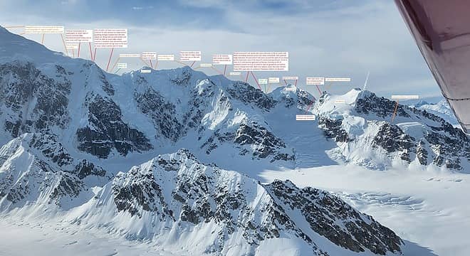
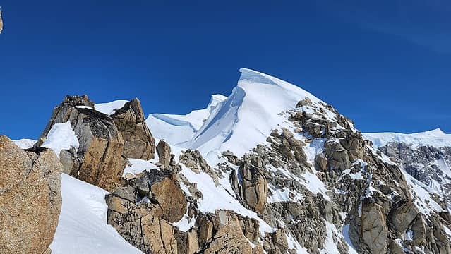
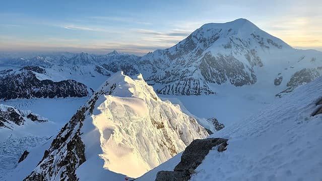
After descending down the Root Canal icefall back to the Ruth Gorge, and flying out from the Ruth we took a rest day in Takleetna and on May 29th we flew into the Kahiltna base camp and walked down the glacier a couple miles to the base of Hunter's west ridge. The image below, taken from the flight in I have annotated which summarizes the route quite well.

Annotated View of the route; View in full resolution or contact me for original


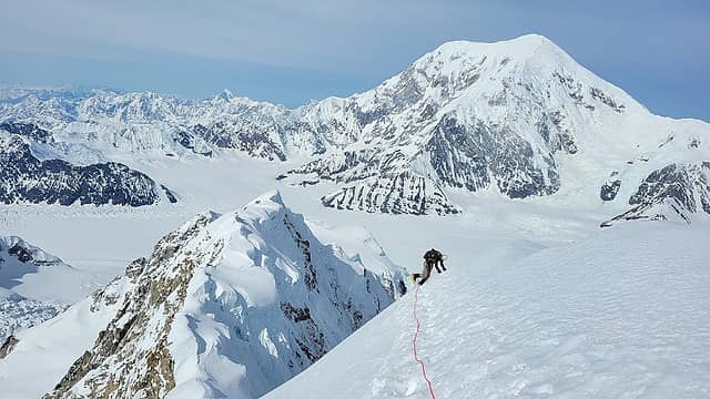
The entry basin was firm in the late morning when we started up. At its steepest we hit about 45 degree snow for a couple hundred feet, and crossed a few decent snow bridges but was pretty easy getting to the flat bench, and the slog to the Cats Ears had minimal postholing. We passed through the notch between the two rock towers and located the first anchor, did a 45 meter rappel to the second anchor and made a second 50 meter rappel down to the easy snow below and walked to the low col. Continuing on, we did two full pitches of AI3 ice climbing, trending right as I climbedand placed a couple screws on each pitch. This whole area I had done 6 years ago during my 2016 attempt so I remembered it well.

Climbing the ice


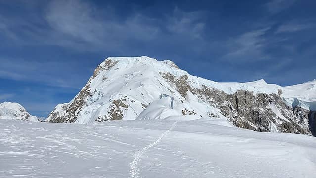
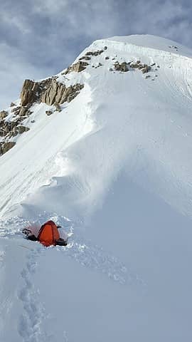
After finshing the two ice pitches, we walked along the snowy ridge up and over Point 9500, climbing another small ice step near its summit, and descending down to the col at the start of the mixed section. Here we dug out a nice tent platform and made camp for the first night. Temps were slightly above freezing at night, calm and clear. Perfect weather.

Mount Foraker from our first camp


The next morning we started climbing the rock band, which involved traversing around to the right (south) side of the ridge to bypass an initial rock tower and make an ascending snow traverse on two steep 55 degree snow slopes, separated by an exposed rock ledge traverse and a corner to scramble around. At the far east side of the second snow slope, we began climbing a narrow gully which involved 60+ degree AI2+ and some low 5th class rock. We continued up this gully almost all the way back to the ridgecrest where two options then presented itself.

Climbed this gully to gendarme after snow traverses


Right at the crest, and to the climbers left of a prominent gendarme is the 40-50 foot Beckey chimney (5.8 in difficulty). Just before the crest though, and climbing to the right of the gendarme is another, drier rock pitch that we took that also involved some 5.8 rock climbing (20 feet max) and not sustained. Sarah did great leading through these short rock pitches and routefinding through. After a few hours we emerged onto easier terrain at the top of the rock band several hundred feet above our camp.

Looking ahead after finishing the mixed section


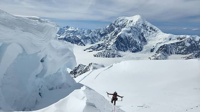
We then continued walking an easy stretch, bypassing the first of two a heavily corniced peaks to the right by climbing a section of 60 degree snow. Some additional walking brought us to a larger corniced peak that involved another traverse right and a short ice step to surmount, which we made into a short pitch and I put one screw in for. Next there was a decently long but flat easy section of ridge that we just walked along. We were actually following fresh tracks since a party of two had just descended this part of the ridge after camping at the 10650 col the a couple nights prior. They had arrived at our camp 1 about midnight, taking quite a bit of time to descend the rock band. We would later find out they did not continue past the 10650 col camp 2.

Flat section of ridge


Just before reaching the top of point 10820, a short 50 foot AI3 ice step was encountered that was nice to break up the walking for a bit. I led up placing one screw and set a picket belay at the top. After this it was another easy walking section down to the 10650 col where we set up our 2nd camp. We would leave the overnight gear here and go for the summit the following day.

Arriving at our camp...what a view!
Nice platform for the tent


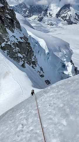
The following morning, we started climbing about 8:30am and right away were greeted with difficulties. The 3-4 pitch AI3 ice face we read about was no longer ice at all. Sugary, poor quality snow increased in steepness to 70 degrees as we ascended rightward to bypass the vertical ice directly above on the ridgecrest. A smaller snow cornice was easier to hack through further right, but neither of us liked the 65-70 degree snow leading up to it. Sarah got up to a rock while I belayed off a picket, and then I led through the cornice, digging my way through and gingerly climbing up on less than inspiring feet in the sugary snow. I anchored on another rock, belayed Sarah up and she made one more lead through some 4th and low 5th rock bands until we emerged into a 250 foot 50 degree snow slope that would take up back to the ridgecrest. We followed some old tracks here likely from one of the parties that descended the west ridge after climbing the north or west buttresses routes a couple weeks prior. Once reaching the crest again, huge cornices greeted us, with a very narrow band of walkable terrain between the cornices and the quickly steepening snow slope below. Three ropelengths of horizontal traversing was required to reach the 11300 foot col atop the Ramen couloir route. This horizontal traverse also had a small ice step midway through, making this the scariest part of the route for me, as the snow was poor, and I was only comfortable doing it front-pointing as the snow would slip out if I walked normally. I was not looking forward to repeating this traverse in the afternoon when the snow softened even more.

Sarah on the horizontal traverse


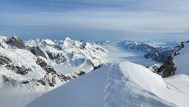
We took a quick rest at the 11300 col atop the Ramen Route. It had taken 3 hours to get to this point, barely 800 feet above camp and we still had over 3000 feet to go. Thankfully, the next 1500 feet went quick as we ascended 35-40 degree firm snow slopes, with one short AI2+ ice step at about 12700 feet. Weaving through the large seracs was easier than it looked from below, which we were able to do by trending slightly to the right at the 12500 foot area. We were dumped onto the wide summit plateau at 12900 feet off to the right of the hige steep serac guarding the plateau in the middle of the face. Here we began a long slog up gentle slopes to the base of the summit area. Off to the right of the true summit, a passage of consisting of 350 feet of 40-50 degree snow brought us to the summit ridge where a long flat section of ridge is located, about 600 feet below the summit. We then turned north and ascended the ridge to the highest point. The ridge itself was pretty easy, with just a couple 50 degree ice steps and good snow.

Nearing the summit ridge


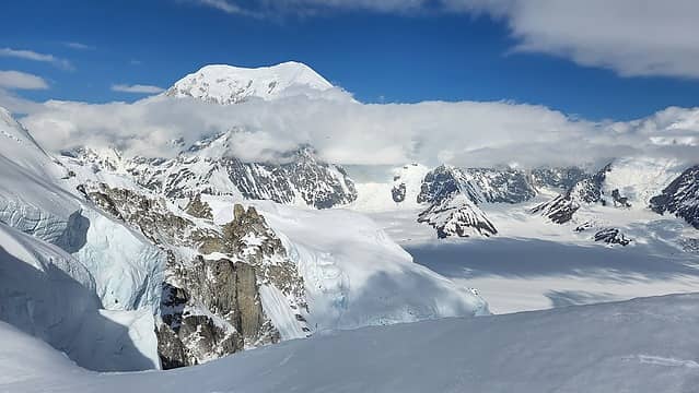
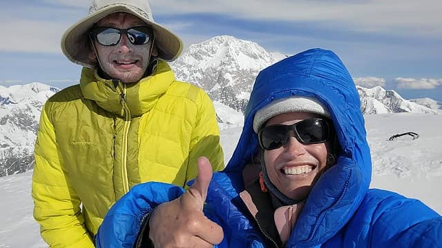
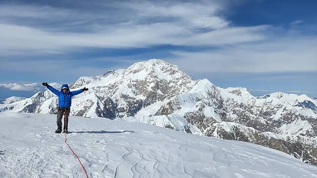
Just before 5pm we stood on the summit, and I had finally climbed Mount Hunter! We were pretty elated, and worn out, and very low on food. I drank most of my remaining water and after some photos, and admiring the stunning views of Denali we retraced our steps.

Summit selfie...I look terrible
Sarah with Denali behind


The entire descent down to the Ramen col was quick and painless, however it took us an additional 2.5 hours to make the descent from there back to the tent as the snow on the horizontal traverse and down the face was so bad I wanted to picket belay every ropelength. Downclimbing the ice step midway through the horizontal traverse was one of the scarier things I can say I have done too. Once at the top of the steep cornice, we made one double rope rappel down the very steep sugar snow down to where we could easily walk back to the tent, which we arrived at about 10pm. No dinner was had by either of us and we went right to sleep.

Sunset as we continue descending


The next morning we slept in, and didn't get started until 9:30am. We continued descending the entire ridge, making great time getting back to the top of the rock band. It did take a couple hours to rappel and downclimb back to the bottom, but there was so much tat and anchors that we were able to just make single rope rappells to get all the way back, which reduced the chance of ropes getting stuck somewhere. The snow slopes were beginning to get very soft in the hot sun, and a few times I sunk past my waist in snow. We made a quick stop for water at our first camp and realizd the entire rest of the descent was going to be on very soft snow. We ascended back over Point 9500 and it took quite some time to make a total of three double rope V thread rappells down the ice pitches on the west side of Point 9500. Once back at the col below the Cats Ears, it was a grueling re-ascent 2 ropelengths up, with a 5.6 crux at the top. Then miserable posthole city the whole way down the flat bench and the entry basin. Thankfully it was all downhill at that point, but the late evening sun was baking the NW facing basin as we descended it making the snow very soft. We finally got back to the tent sometime between 11 and midnight.

Rapping the Beckey chimney
Back on the Kahiltna


We made the mistake of sleeping in too much the following morning, because by the time we got back to the airstrip, we had missed the last flight out of base camp by only 10 minutes! We did not know they were only doing morning flights due to the warm conditions, so we were stuck waiting at base camp another 18 hours just wasting away. I was pretty pissed, and passed the time by watching a few guided Denali groups make their preparations to leave early the next morning. It was a very slow afternoon and night where I could not sleep since it was so hungry. That was my third night in a row now with no proper meal and I was really starting to feel the hunger. By 8:30am the next morning, we were first to fly out, and once getting back to Talkeetna I think I stopped at every single resturant in town throughout the rest of the day and probably spent $100 on food that day. Totally worth it.

Looking back up at Hunter from base camp


Some additional notes that may be of use:
1. For climbing gear, we brought two 7.3mm ropes; one 60m and one 50m (the 50m was purely by accident, I would have liked to have had another 60), 5 ice screws, 4 cams (0.5" - 2"), set of DMM nuts, 5 single length slings, 1 double length sling, BD Stinger crampons, pair of Petzl Quarks (Sarah had her Nomics), and I had my BD couloir UL harness.

2. For overnight gear, we used Sarah's MSR Advance Pro 2 tent, which was very tight for the two of us. I used a Big Agnes 20 degree UL bag, and had two sleeping pads (I always bring an air and a foam when camping on snow). We had a single MSR Reactor for cooking/melting snow and 4 fuel canisters (which was probably too much).

3. We brought snowshoes just for the walk from base camp to the base of the west ridge and ditched them at the base. We were lucky conditions on the summit plateau were so firm...just two weeks prior the snow conditions were heinous for the party who climbed the FA of the west buttress, as they were sinking to their knees or more for 12 hours.

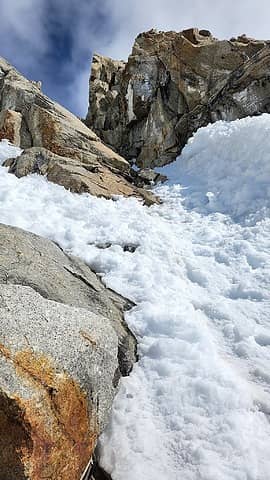
4. There is a pointy, somewhat tall rock with lots of TAT around it right at the top of the rock band that would seem to make a great first rappel anchor to start descending the rock band. This rock moved on me when I was rapping on it. Do not use this rock, and downclimb about 20 feet to another anchor on a ledge closer to the vertical dropoff.

5. We contemplated for a long time whether to descend the Ramen couloir and take the icefall bypass instead of just descending the west ridge. The following factors are what had us eventually decide to just descend the ridge.
a - The Ramen couloir was getting baked everyday (south facing), and would not offer good snow for descending
b - The icefall itself would likely be impassible by this point with all the warm weather.
c - The icefall bypass we read required a full 60 meter rappel down "an icefall" which we read later in the season becomes "a waterfall". We did not know if we could set up an intermediate anchor on this since one of our ropes was only a 50m.
d - After getting around the icefall, it would have been almost a 3 mile slog back to the base of the ridge.
e - We were familiar with all the obstacles on the ridge and had good tracks to follow.
f - We did not want to carry packs up the terrible section of the route just above the 10650' col to get to the Ramen col at 11300 feet.
If you find yourself on the west ridge, differing conditions may incline you to descend the Ramen route.

Feel free to reach out to me if anyone would like more beta or the original full rsolution annotated route photo shown above. This was a climb I was thrilled to be able to complete, and one of the more notable routes I have completed in my climbing career. Nothing super noteworthy in the grand scheme of alpine climbing, but definitely an accomplishment for me as I get lazier each passing year.

Proudly powered by Weebly