LEMKE CLIMBS
  • About
    • Whats New
    • 2019 Goals/Wishlist
    • Contact
  • Washington
    • North Cascades >
      • Sahale Peak, Boston Peak
      • Eldorado Peak, Klawatti Peak
      • Black Peak
      • Forbidden Peak West Ridge
      • Primus Peak Attempt
      • Big Snagtooth
      • Liberty Bell Beckey Route
      • Burgundy Spire North Face 5.8
      • Ragged Ridge - Katsuk, Kimtah and Cosho Peaks
      • Colfax Peak
      • South Early Winters Spire via SW Buttress
      • Chilliwack Mini-Slam
      • Mesahchie Peak
      • Inspiration Traverse
      • Mount Shuksan Ski
      • Full Pickets Traverse
      • Mount Goode NE Buttress & Storm King
      • Mount Baker North Ridge WI3
      • Snowfield Peak
      • Lincoln Peak
      • Silver Star Mountain
      • Mount Buckner & Horseshoe Peak
      • Azurite Peak
      • Tower Mountain & Golden Horn
      • Mount Logan
      • Custer Ridge & Easy Mox
      • Mazama Dome
      • Sherman Peak
      • Mount Ballard
      • Southern Pickets Traverse
      • Corteo Peak
      • Whatcom Peak
      • Castle Peak
    • Glacier Peak Wilderness >
      • Buck Creek Pass, Cloudy Peak, Spider Gap
      • Dome Peak, Spire Point
      • Mt. Maude and Seven Fingered Jack
      • Mount Formidable NE Face 5.6 Second Ascent
      • Dumbell and Greenwood Mountains
      • Glacier Peak Wilderness Mountain Massacre
      • Clark and Luahna Peaks
      • Sinister Peak
      • Chiwawa Mountain
      • Tupshin & Devore Peaks
      • Buck & Fortress Mountains
      • Glacier Peak
      • Snowking Mountain
    • Olympic Peninsula >
      • Buckhorn Mountain
      • Flapjack Lakes Hike
      • Grey Wolf Peak, High Divide Trail
      • Mount Ellinor
      • Mount Constance West Arete
      • Mount Olympus
    • Alpine Lakes Wilderness >
      • Chikamin Peak
      • PCT - Snoqualmie to Pete Lake
      • Necklace and Tank Lakes
      • Enchantments Day Hike
      • Granite Mountain (Snoqualmie)
      • Colchuck Peak
      • Cannon, Enchantment and Stuart
      • Ingalls Peaks
      • McClellan Peak
      • Dragontail Peak
      • Web Mountain
      • Mount Index Attempt
      • Snow Creek Wall Orbit 5.8+
      • The Tooth South Face
      • Eightmile Mountain
      • Argonaut Peak NE Couloir
      • Little Annapurna South Face 5.5
      • Snow Creek Wall Outer Space 5.9
      • Cashmere Mountain
      • Sherpa Peak North Ridge 5.8
      • Chair Peak NE Ridge
      • Lichtenburg Mountain
      • Mount Index
      • McClellan Butte
      • Chimney Rock
      • Alpine Lakes High Route
    • Pasayten Wilderness >
      • The Craggies
      • Tiffany Mountain
      • Pasayten Mini-Slam
      • Remmel Group
      • Jack Mountain
      • Robinson Mountain
      • Monument Peak Group
    • Mountain Loop Highway >
      • Vesper Peak
      • Mount Dickerman
      • Sloan Peak West Face 5.8
      • Mount Forgotten
      • Whitehorse Mountain
      • Gothic Peak
    • Lake Chelan Sawtooth Wilderness >
      • Star, Courtney, and Grey Peaks
      • Hoodoo Peak and Raven Ridge
      • Abernathy Peak
      • Mount Bigelow
      • Reynolds Peak
      • Oval Peak
      • Gardner Peaks
      • Chelan Sawtooth Trio
    • Southern WA >
      • Mount Adams
      • Mount Rainier - Emmons Route
      • Mount Saint Helens
      • Goat Peak
      • Lane Peak, Plummer Peak (Tatoosh)
      • The Unicorn (Tatoosh)
      • Little Tahoma
      • Liberty Cap
    • WA Rock and Ice Cragging >
      • Index Town Walls
      • Vantage
      • Mount Erie
      • Exit 38
      • Leavenworth
  • Colorado
    • San Juan Mountains >
      • Mount Sneffels Lavender Snow Climb
      • Uncompahgre, Matterhorn Peaks
      • Redcloud, Sunshine Peaks
      • San Luis Peak
      • Vermilion, Fuller Peaks
      • Stewart Peak, Baldy Alto
      • Jones, Niagara, American Peaks
      • Wetterhorn Peak, Handies Peak
      • Wilson Group
      • Arrow Peak
      • Mount Sneffels SW Ridge
      • Jagged Mountain, Chicago Basin
      • Teakettle Mountain
      • Dallas Peak
      • Vestal Peak Wham Ridge, Greystone Peak
      • Organ Mountain
      • Phoenix Peak
      • Half Peak
      • Point 13832 Group
      • Golden Horn
      • Mount Sneffels Snake Couloir
      • Pigeon, Turret Peaks
      • Trinity Peaks
    • Elk Mountains >
      • Four Pass Loop
      • Castle, Conundrum Peaks
      • Snowmass Mountain
      • Cathedral Peak
      • South Maroon Peak
      • The Pyramids
      • North Maroon Peak, Sleeping Sexton
      • Capitol Peak, Mount Daly
      • Malemute Peak
      • Hagerman Peak
    • Sangre de Cristo Mountains >
      • Blanca Peak, Ellingwood Point
      • Challenger Point
      • Mount Adams
      • Spread Eagle Peak
      • Humboldt, Obstruction, Columbia Peaks
      • Mount Lindsey, Huerfano Peak
      • Little Bear Peak
      • Crestone Needle Ellingwood Arete
      • California Peak
      • Crestone Peak North Buttress
      • Operation Dark Snake
      • Kit Carson Mountain
    • Sawatch Mountains >
      • Iowa Peak
      • Point 13,618 - Hunky Dory Lake
      • Gold Dust Peak, Notch Mountain
      • Mount Jackson
      • Mount Belford
      • Shavano, Tabeguache Peaks
      • Mount Antero, Cronin Peak
      • Twining Peak
      • Mount Massive
      • Casco Peak
      • Mount Huron
      • Mount Elbert
      • Mount Oxford
      • Mount Hope
      • Mount Yale
      • Lackawanna Peak
      • Mount Columbia
      • La Plata Peak
      • Rinker and Twin Peaks
      • Bull Hill, Mount Princeton
      • Missouri Mountain
      • Mount Oklahoma
      • French Mountain
      • Mount Ouray
      • Grizzly A, Garfield Peaks
      • Mount Harvard
      • The Three Apostles
      • Emerald Peak
      • Holy Cross
      • Mount Aetna
      • Deer Mountain
    • Greater Park Range >
      • Kneeknocker Pass, Piney Lake
      • Drift Peak
      • Sherman Peak, Dyer Peak
      • Gore Range Traverse
      • Quandary Peak
      • Pacific, Atlantic Peaks
      • Clark Peak
      • Crystal Peak, Peak 10
      • Fletcher Mountain
      • The DeCaLiBron
      • Loveland Mountain
      • The Mosquito Traverse
      • Mount Arkansas
      • Clinton Group
      • Eagles Nest, Peak C
      • North Star Mountain
      • Peak X
      • Wheeler Mountain
    • Front Range >
      • Mount Evans, Spalding
      • Mount Bierstadt
      • Mount Parnassus, Bard Peak
      • Cupid, Sniktau, Grizzly D Peaks
      • James Peak
      • Mount Silverheels
      • Grays and Torreys Peaks
      • Mount Edwards
      • Mount Flora, Longs Peak
      • Square Top Mountain
      • Petit Grepon South Face 5.8
      • Mount Meeker Dreamweaver Couloir
      • Santa Fe Peak
      • The Citadel & Pettingell
    • Colorado Ice Climbing >
      • Lincoln Ice Falls
      • Ouray Ice Park
      • Avocado Gully and The Drool
      • Hidden Falls
    • Colorado Rock Climbing >
      • Eldorado Canyon
      • The Flatirons
      • North Table Mountain
      • Colorado National Monument >
        • Independence Monument
  • Wyoming
    • Wind River Mountains >
      • Gone With the Winds
      • Union Peak - Solar Eclipse
      • Wind River Peak
      • Wind River Slam
    • Teton Range >
      • Grand Teton Owen Spalding 5.4
      • Mount Owen Attempt
    • Wyoming Absarokas and Gros Ventre Range >
      • Jackson Peak
      • Francs Peak
    • Yellowstone National Park >
      • Top Notch Peak
    • Bighorn Range and Great Divide Basin >
      • Boars Tusk
      • Loaf Mountain
      • Cloud Peak
      • Black Tooth Mountain
    • Devils Tower
    • Cody Rock and Ice Climbing
  • Montana
    • Beartooth Mountains >
      • Whitetail Peak Group
      • Beartooth Mountain
      • Spirit Mountain Group
      • Mount Peal
      • Granite Peak Group
      • Castle Rock Group
      • Castle Mountain NE Couloir
      • Mount Inabnit and Sylvan Peak
      • Mount Hague South Slopes
      • Mount Villard and The Granite Peaks Traverse - 5.4
      • Spirit Mountain NE Ridge - 5.4
      • California Ice WI 4
      • The Ramp 5.8
      • Linea Alba 5.10d
      • Iceberg Peak
      • Metcalf Mountain North Rib 5.8
      • Villard Spires HP West Ramp
      • Cairn Mountain
      • Snowbank Mountain
      • Mount Wood Group
      • Bears Tooth
      • Glacier Peak Catch-a-Sunrise FA
    • Southwest Montana Ranges >
      • Madison Range >
        • Koch Peak
        • Sphinx Mountain
        • Beehive Peak
        • South Sheep Mountain
      • Gallatin Range
      • Bridger Range >
        • Sacajawea Peak
        • Saddle Peak
        • Baldy Mountain
        • Ross Peak
      • Montana Absorakas >
        • Arrow Peak
        • Black Mountain
        • Mount Cowen
      • Tobacco Root Mountains >
        • Hollowtop Mountain
        • Belle Point
        • Noble Peak
        • Leggat Mountain
      • Crazy Mountains >
        • Crazy Peak
    • Glacier National Park >
      • A Taste of Glacier National Park
      • Divide Mountain
    • MT Rock and Ice Climbing
  • Utah
    • Uinta Mountains >
      • Kings-Emmons Ridge Run
      • Hayden Peak
      • Iron Hayden Wall Rock Climbing
    • Wasatch Range >
      • The Sundial Eleventh Hour 5.8
      • Mount Timpanogos
    • San Rafael Swell >
      • Ramp, Cistern Canyons
      • Salt Wash, Black Mountain, Moroni Slopes
      • Ding, Dang Canyons
      • Little Wild Horse, Bell Canyons
      • Quandary Canyon
      • San Rafael Knob
      • Miners Hollow (Knotted Rope Canyon)
      • Temple Mountain
      • Chimney Rock
      • Bottleneck Mesa
      • Window Blind Peak
      • Lower Baptist Draw & Upper Chute Canyon
    • Capitol Reef National Park >
      • Cathedral Valley Tour
      • Sheets Gulch
      • Halls Creek Narrows
      • Brimhall Canyon and Strike Valley Overlook
      • George Benchmark
    • Moab Area, Canyonlands, Arches >
      • Maze District
      • Needles District
      • Maze District
      • White Rim Trail Biking
      • Elephant Butte, Bullwinkle Tower and Lizard Rock
      • South Six Shooter
      • Elephant Canyon
      • Parriott Mesa
      • Ancient Art
      • Castleton Tower North Chimney 5.8
      • Klondike Bluffs
      • Mount Peale & Tukuhnikivatz
    • Robbers Roost Country >
      • Horseshoe Canyon, Goblin Valley
      • Bluejohn Canyon
      • Happy Canyon Narrows
      • Shenanigans, Leprechaun Slots
      • Larry Canyon
      • Merry Piglet Slot
      • Lower Maidenwater Canyon, Turkey Knob
      • Morocco Canyon
      • Monkey Business Slot
      • Hog Canyon Slots
      • Upper Maidenwater Canyon Slots
      • Mount Ellen
      • Buck Canyon
      • Point 4906
      • Alcatraz Canyon
      • Hard Day Harvey Slot
      • Mount Ellsworth
      • Good Day Jim Canyon
      • White Roost Canyon
      • Upper Stair Canyon
      • Dragon Canyon
    • Escalante National Monument >
      • Phipps Canyon and Arch
      • Red Breaks Slot
      • Dry Fork Slots, Coyote Gulch
      • Little Death Hollow/Wolverine Canyons
      • Egypt 3 Slot
      • Egypt 1 Canyon
    • Zion/Bryce >
      • Ataxia Tower Ashtar Command 5.9
      • Mount Kinesava Cowboy Ridge
      • Birch Hollow
      • Aires Butte
      • West Temple
      • Mystery Canyon
      • Crazy Streak
    • Cedar Mesa Region/Valley of the Gods >
      • Eagle Plume Tower Eagle Feather 5.10b
  • California
    • High Sierras, Southern CA Ranges >
      • Telescope Peak, Manly Beacon
      • Tahquitz Rock Whodunit 5.9
      • Tahquitz Rock Long Route 5.9
      • Palisade Traverse
      • White Mountain
    • Yosemite National Park, Central CA
    • Northern CA Cascades >
      • Lava Beds National Monument
      • Mount Shasta
  • Oregon
    • Oregon Volcanoes >
      • Three Fingered Jack
      • Mount Scott
    • Blue Mountains >
      • Twin Peaks
    • Trout Creek Rock Climbing
  • Alaska
    • Eagle Peak and Mount Ewe
    • Jatt Peak and Portage Pass
    • Rainbow Peak
    • Mount Brooks Attempt
    • Arrigetch Peaks Trek
    • Ab Mountain Hike
    • South Suicide Peak
    • Mount Hunter West Ridge Attempt
    • Cantata Peak Attempt
    • East Twin Peak
    • Mount Alice
    • Crow Pass and Hope Point Hikes
    • Indianhouse Mountain Attempt
    • Lynx Peak
    • Harding Icefield Hike
    • Hatcher Pass and Grapefruit Rocks Climbing
    • Mount Sanford
    • Mount Hunter West Ridge
    • Mount Fairweather
  • Nevada
    • Ginger Cracks 5.8
    • Mescalito Dark Shadows 5.8
    • Birdland and Olive Oil
    • Frogland 5.8
    • Johnny Vegas 5.8
    • Schaeffer's Delight & Triassic Sands
    • Solar Slab - 5.6
  • British Columbia
    • Mount Matier
    • Taiya Peak
    • Bugaboo Spire NE Ridge
    • Mount Sabine Easy Honey 5.10b
    • Mount Sir Donald NW Ridge Attempt
    • Black Tusk
    • Slesse Mountain NE Buttress
    • Warden Peak
    • Triple Peak
    • Gimli Peak
    • Mount Waddington
  • Alberta
    • Mist Ridge Hike
    • Mount Temple Attempt
    • East Wendell Peak
    • Loder Peak
    • Tower Mountain Attempt
    • The Rimwall
    • Mount Yamnuska Directissima 5.9
    • Mount Lawrence Grassi
    • Mount Lorette
    • Roche A Perdrix
    • Mount Edith Cavell East Ridge 5.3
    • Mount Louis Kain Route
    • Eiffel Peak
    • Mount Alberta
    • Canadian Rockies Ice Climbing
  • Other States
    • Arizona >
      • Grand Canyon Bright Angel Trail
      • Beanfest at Cochise Stronghold
      • Baboquivari Peak
      • Humphreys Peak
    • New Mexico >
      • Philmont Trek August 2008
    • Yukon >
      • Canyon Peak
  • International
    • Mexico & Central America >
      • Mexico - Pico de Orizaba, Izta
      • Guatemala Volcanoes
    • South America >
      • Chile >
        • An Introduction to Patagonia
        • Exploring Pucon and Lanin Volcano
        • Cerro Puntado & Palo
        • Cerro Colorado
        • Cerro Puno & Agudo
        • Cerro Trinidad Attempt
        • Volcan Quetrupillan
        • Cerro Placas
        • Volcan Puyehue
        • Cerro Conico
        • Cerro Barros Arana
        • Cerro Cordillerano
        • Ojos del Salado
      • Argentina >
        • Nahuel Huapi National Park & The Frey
        • Cerro Helio Azul & Tronador Attempt
        • Aguja Guillaumet Amy Couloir
        • Nevado de Acay
        • Chiaro de Luna
      • Peru >
        • Cordillera Blanca - Tocllaraju and Urus
        • Cordillera Blanca - Ishinca Peak and Artesonraju
        • Cordillera Blanca - Quitaraju & Alpamayo
        • Exploring Southern Peru
      • Bolivia >
        • Pequeno Alpamayo
        • Huayna Potosi
        • Illimani
    • Oceania >
      • Exploring New Zealand's South Island
      • Puncak Jaya
      • Mount McPherson and Talbot
      • Single Cone
      • Mount Cook
      • Mount Aspiring
      • Manakau
      • Mount Wilhelm
    • Central Asia >
      • Kyrgyzstan 2021
    • Europe >
      • Iceland & Faroe >
        • Snaefellsjokull
        • Kaldbakur
        • Slaettaratindur
  • Sorted by Year
    • 2008 Trip Reports
    • 2009 Trip Reports
    • 2010 Trip Reports
    • 2011 Trip Reports
    • 2012 Trip Reports
    • 2013 Trip Reports
    • 2014 Trip Reports
    • 2015 Trip Reports
    • 2016 Trip Reports
    • 2017 Trip Reports
    • 2018 Trip Reports
    • 2019 Trip Reports
    • 2020 Trip Reports
    • 2021 Trip Reports
    • 2022 Trip Reports
    • 2023 Trip Reports
  • Vanlife
    • Conversion Journal >
      • Floor Installation
      • Folding Bed
      • Coffee Table
      • Thinsulate Installation
      • The Couch
      • The Wardrobe
      • Bookshelf
      • Water System
      • Electrical System
      • The Pantry
      • Refrigerator
      • Tire Upgrade
      • Heating System
      • Composting Toilet
LEMKE CLIMBS

guatemala volcanoes

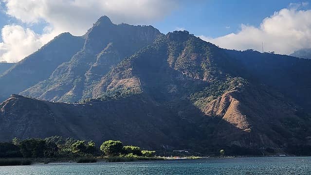
san pedro - 9908' - Class 1
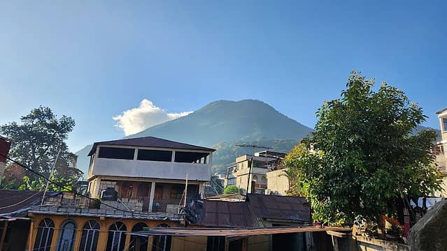
Atitlan Volcano - 11604' - West slopes class 1
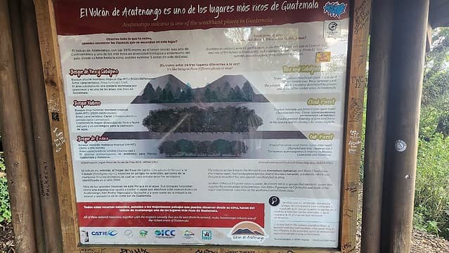
Acatenango volcano - 13041' - Class 1
Tajumulco volcano - 13845' - class 2
December/January 2022/2023

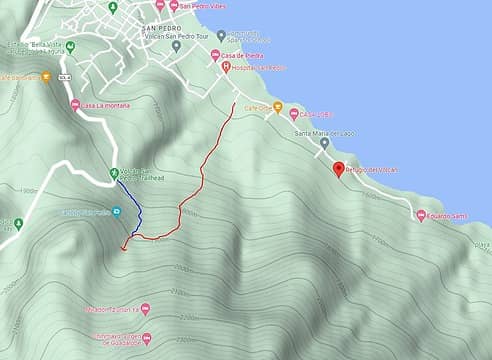
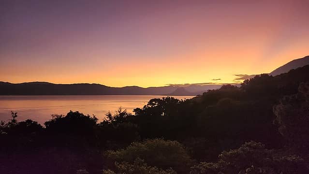
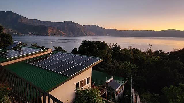
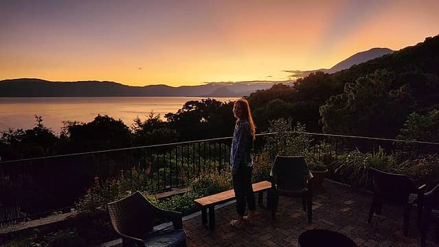
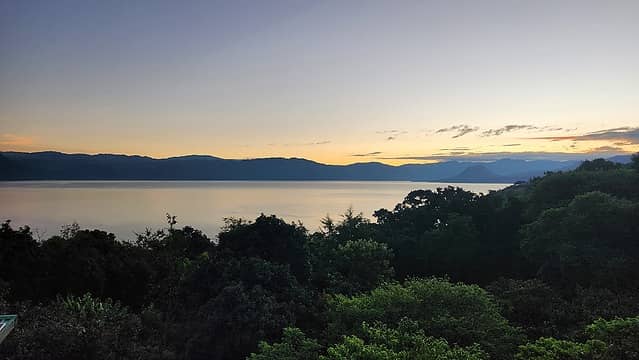
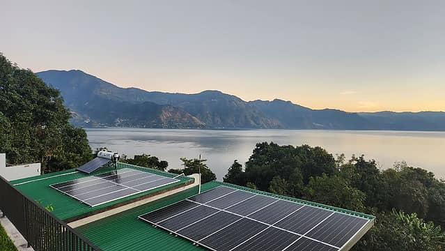
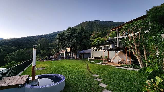
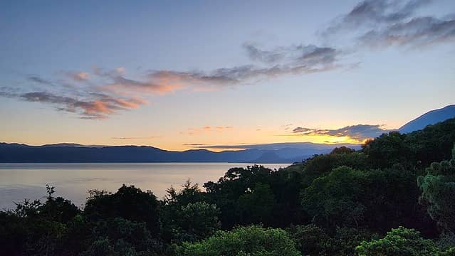
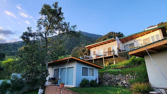
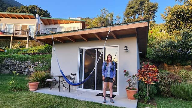
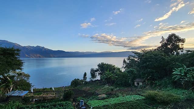
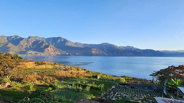
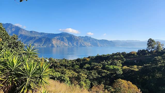
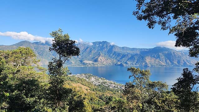
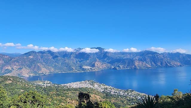
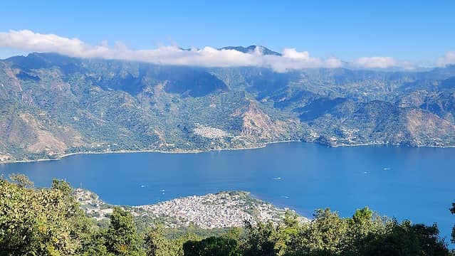
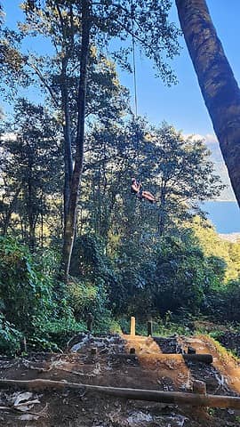
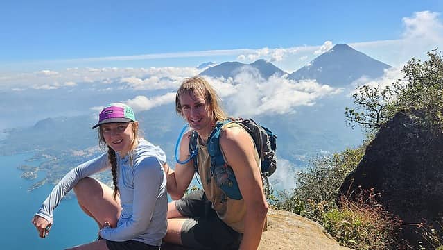
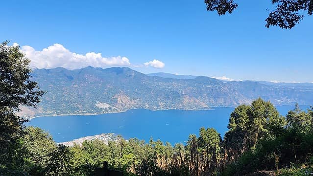
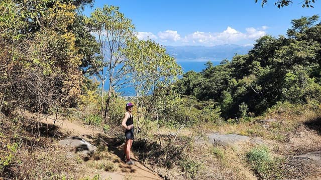
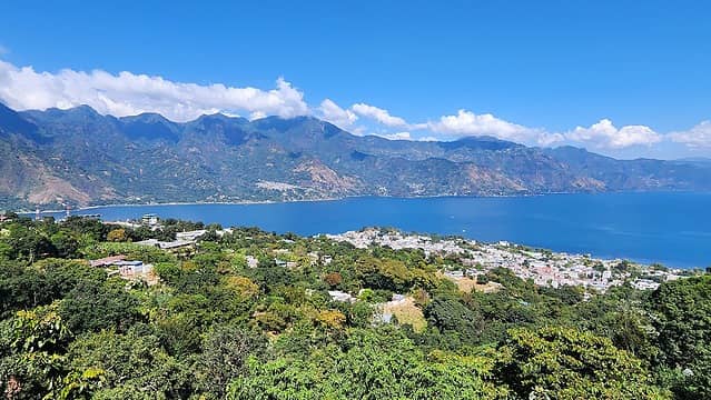
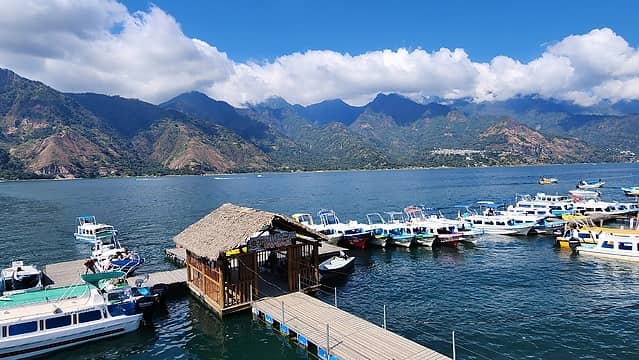
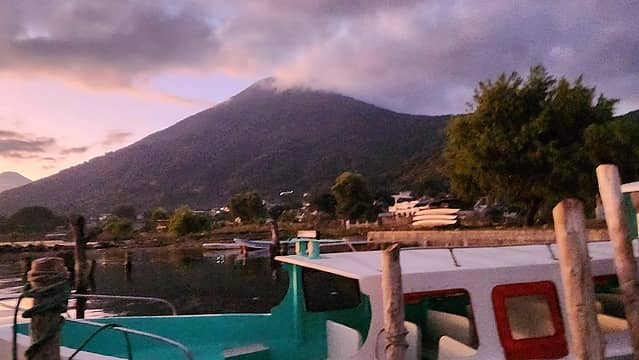
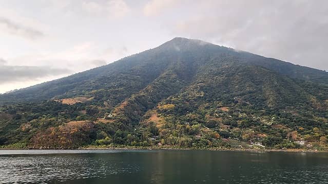
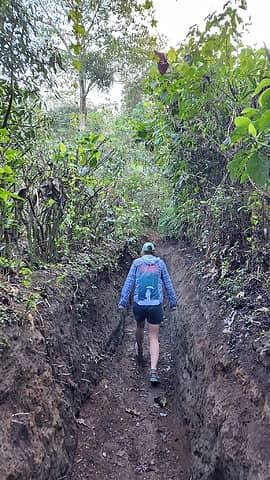
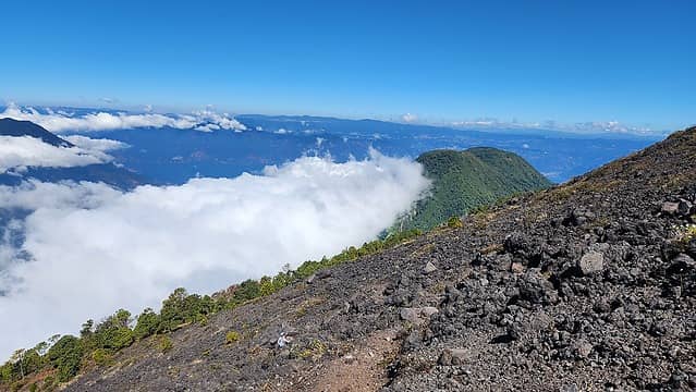
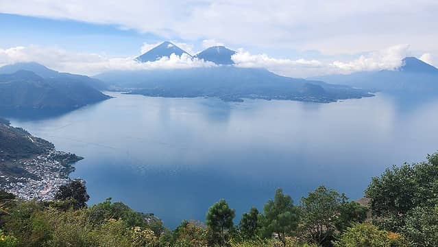
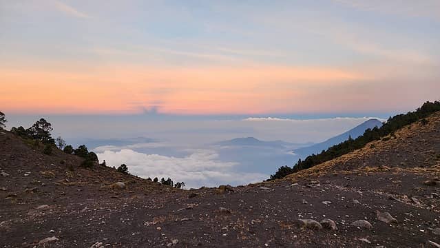
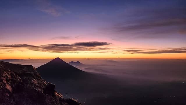
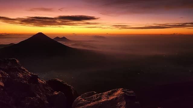
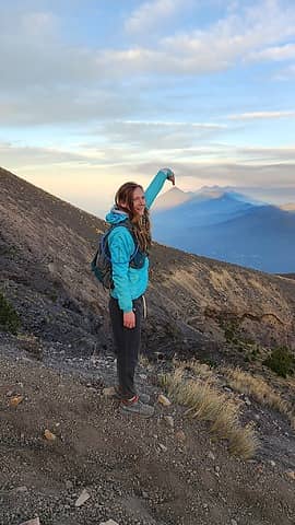
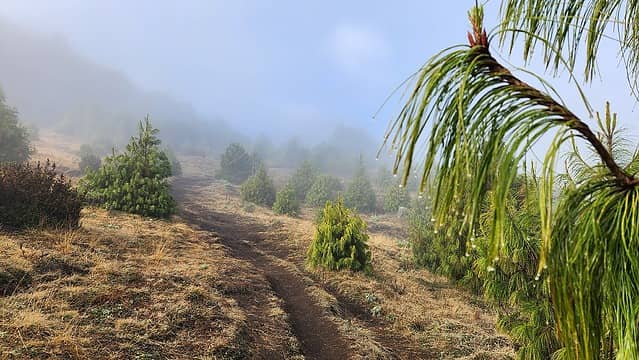
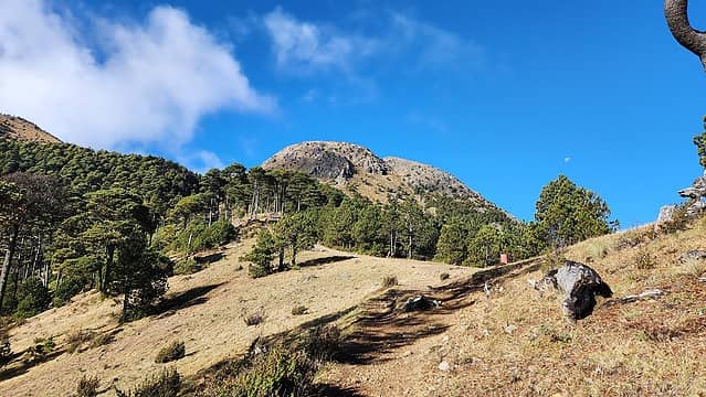
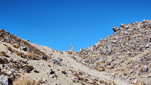
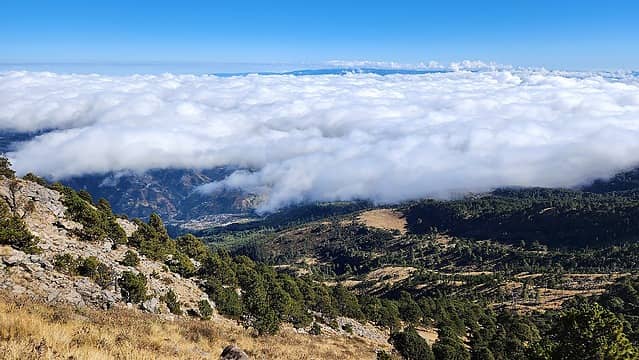
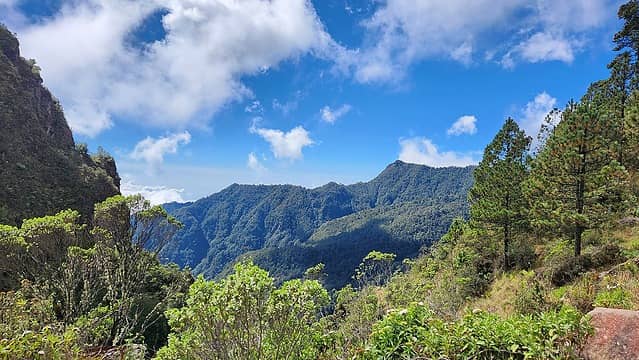
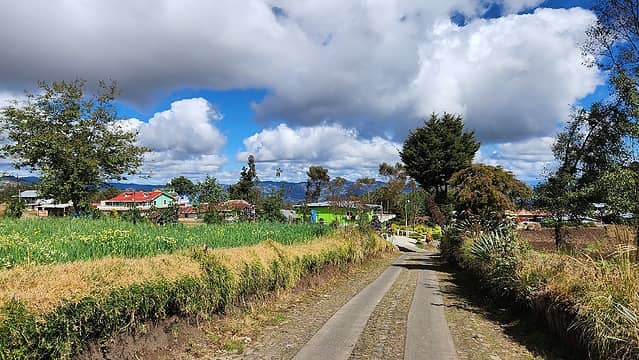
I am happy to be back into action after a relatively inactive 2022 year for climbing and travelling. Due to a work trip I needed to take in Guatemala from January 5-12th, I decided to take a week over new years with Bri to explore Guatemala and hike some of the volcanoes. After a fairly quick flight to Guatemala City from Bozeman we met with our pre-arranged private driver who too us all the way to San Pedro on the southwest side of Lake Atitlan where we would stay at Refugio del Volcan for the next week. We arrived late at 9pm and quickly went to sleep as we wanted to hike up the San Pedro Volcano the following morning. Our host was an American and built the entire AirBB which included small cabins and a beautiful terraced plat of land with excellent lake views. He was very helpful and gave us a tip that we can avoid the San Pedro enterance fee at the standard trailhead for San Pedro at the 1800 meter contour on road SQL-4 (the bad road leading towards Santiago de Atitlan) if we start walking up from a small dead end road off of Calle Finca (the road that leads east from town along the lake towards Refugio del Volcan). I marked this location on the map below (our route in red is approximate). A small series of farmers trails head south up the slopes, weaving through old coffee and banana fields before eventually meeting up with a larger trail that ascends up and leftward. A bit of bushwhacking was needed to reach this larger trail, but when you reach it, we turned right and descended a hundred feet or so and met the main trail that leads to the summit of San Pedro at a dry stream bed where a sign indicates the main trail heads climbers right. We ascended about 1200 feet from the Calle Finca road before meeting the main trail. This allowed us to bypass the enterance booth, but did add an additional 600 feet of elevation gain as most people will just take a Tuk Tuk up the road to the main trailhead. Bri and I then continued hiking up the steep trail at a brisk pace, passing numerous parties on the trail. There was a sweet tire swing a ways further up that we stopped at for some fun. It did not take us long to reach the summit where a beautiful view of the Atitlan Volcano, and the town of Santiago de Atitlan way below us came into view. We ran the entire way down the trail and blazed past the enterance booth out to the road where we were able to pick up snacks and more water/juice at a small tienda along the road. Not wanting to walk the paved road back to town we hopped in a Tuk Tuk to get back to the center of townfor lunch and we met with my longtime friend Kelly who was making the trip with Lorin in their campervan driving down from the US through Central America and eventually all the way to Patagonia. It was just by chance they were also in the Lake Atitlan area the same time we were there. Kelly took a boat across from Panajachel to San Pedro and we explored the town a bit and went swimming in the lake. We then made plans to meet in Santiago de Atitlan early the next morning to hike the Atitlan Volcano. Bri and I felt sore that evening since that was the first fast and steep hike either of us had done in a few months. The photos below show some of the views we had from our AirBB and the hike up and back from San Pedro. This volcano actually rises directly above the town of San Pedro and is an extinct volcano where the top is still largely covered in jungle. The summit elevation of 9908 feet is not high enough to breach treeline but there are a few spots with rocky perches that offer great views.

Our initial route up to avoid the fee
Our first sunrise from Refugio del Volcan
Lake Atitlan Sunrise
 
Lake Atitlan
Refugio del Volcan (entirely on solar)
Hot tub and hangout field at Refugio del Volcan
 
 
Refugio del Volcan cabins
Our homestay for the next week
Lake Atitlan
First rays of sun
San Pedro Volcano looming above
Starting up thru the fields
 
View north across the lake
 
 
Tire swing
 
Atitlan Volcano (right) and Toliman (left)
 
View of Santiago and Atitlan Volcano from the top
Lake Atitlan
 
Other hikers
 
Heading back down the trail
 
Boat dock in San Pedro

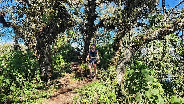
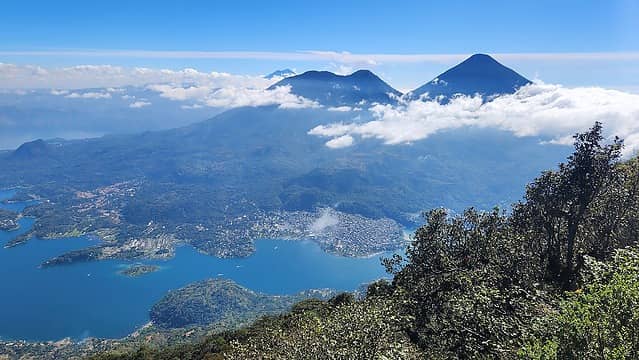
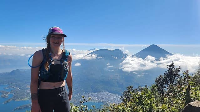
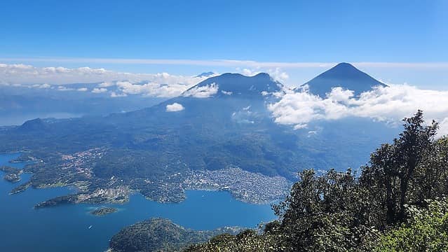
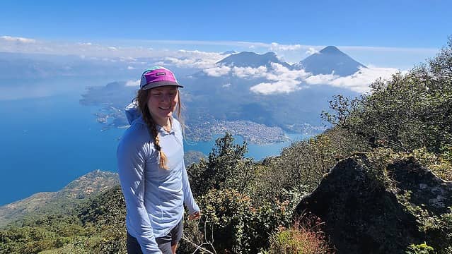
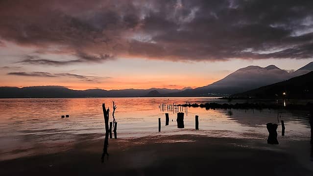
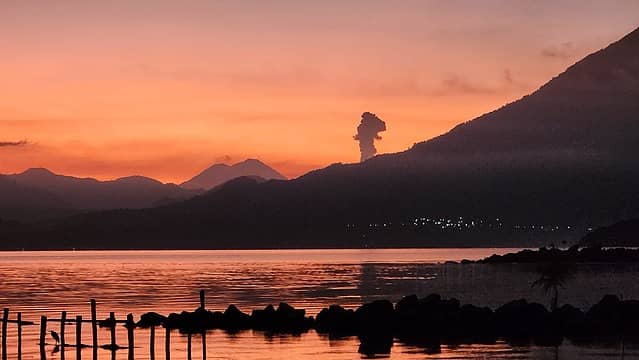
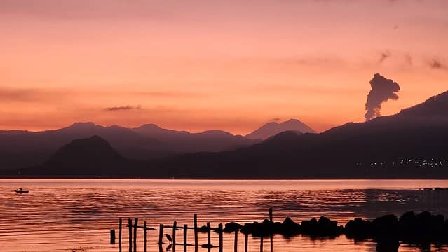
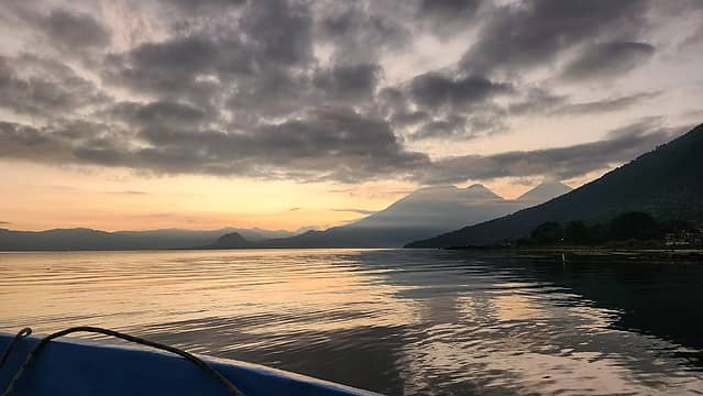
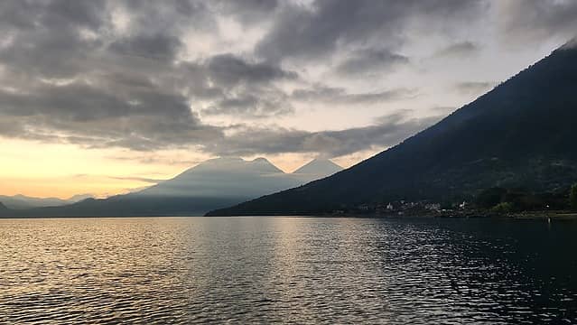
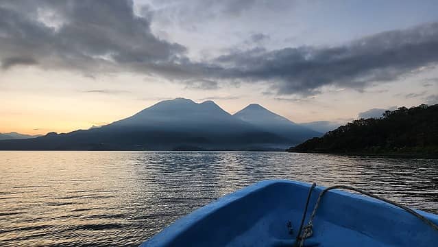
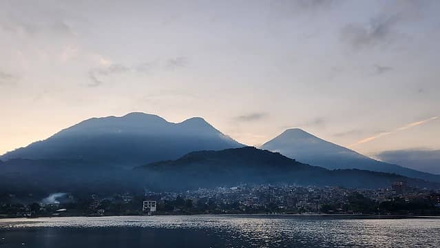
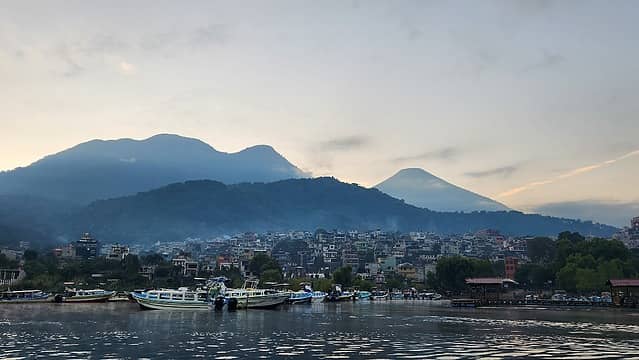
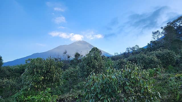
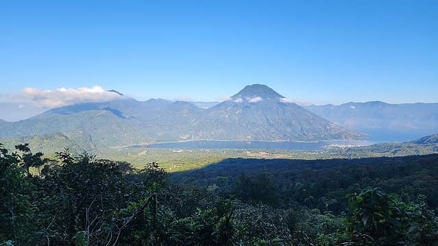
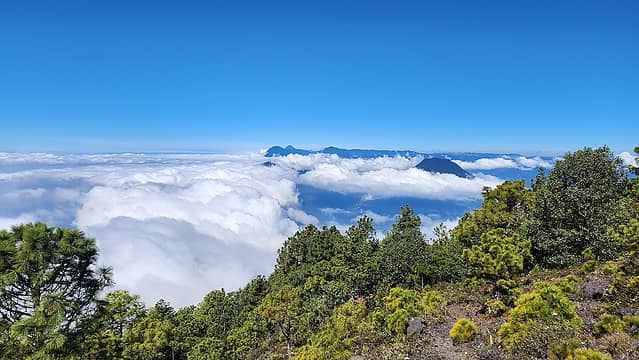
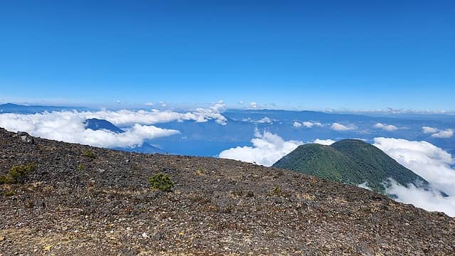
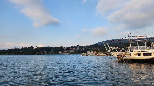
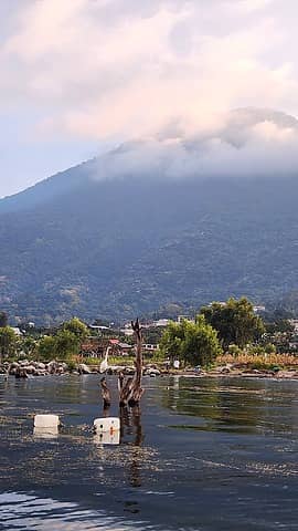
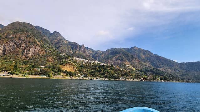
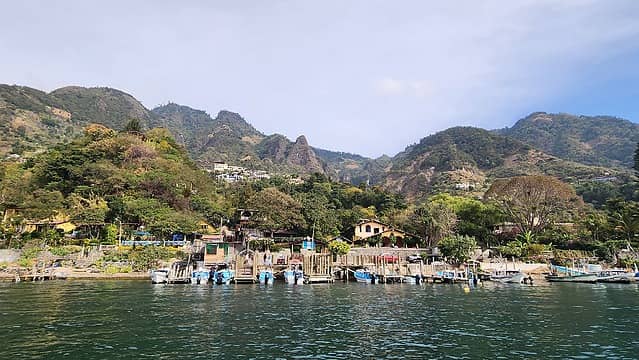
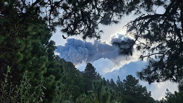
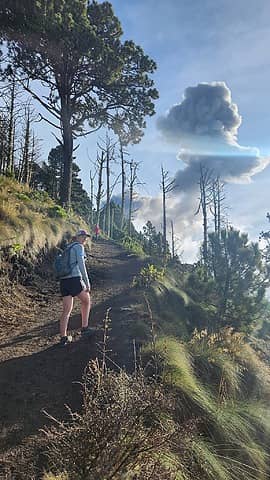
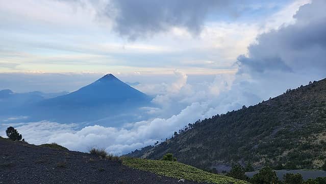
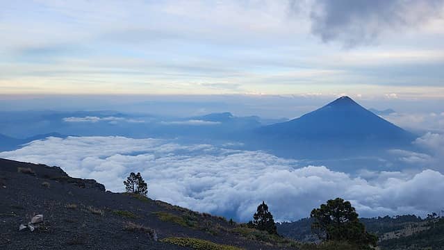
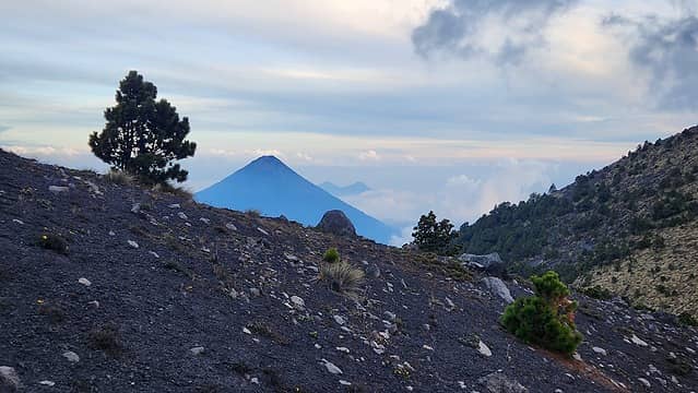
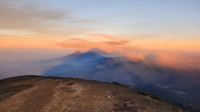
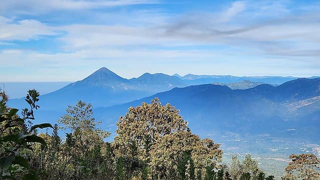
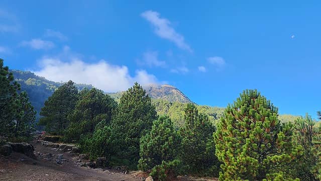
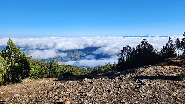
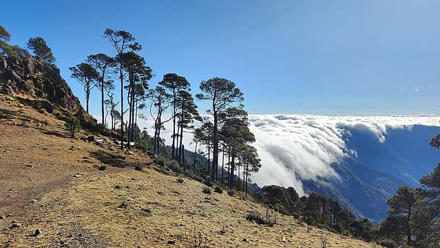
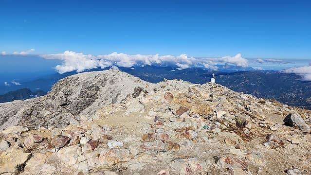
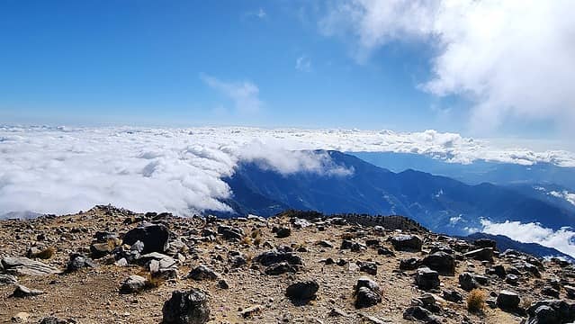
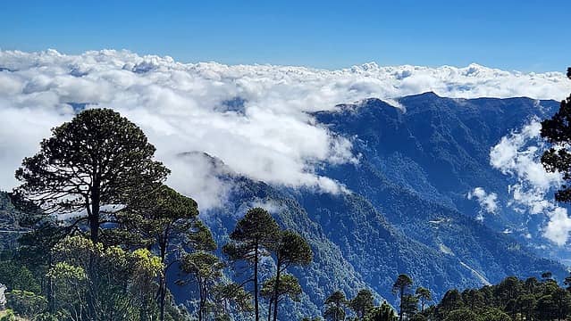
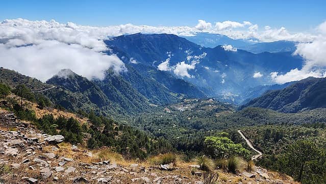
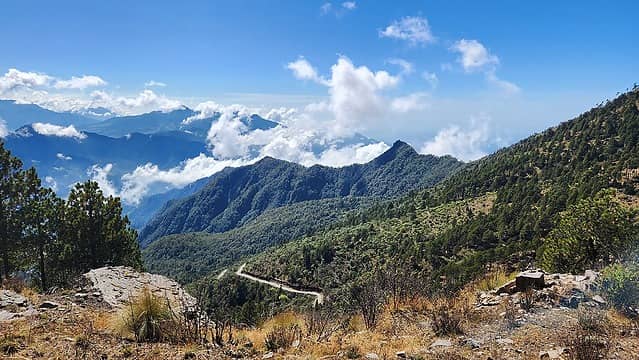
The following morning we took the very first boat over to Santiago de Atitlan, a 15 minute ride along the south side of the lake. As twilight was starting, we saw a plume of ash emmitted from Volcan Fuego far behind Toliman against the blood red sky which got our excitement going for the Acatenango hike we were planning a few days later. Once we got to Santiago, we waited for Kelly to make it over from Panajachel and started to ask around about getting a Tuk Tuk out to the trailhead for Atitlan Volcano. Our intended route was to follow the trail up the west side that led directly to the summit. After asking a few different drivers, one finally understood where we were trying to go and agreed to take all 3 of us there for 50Q each. This was a bit expensive but we didn't want to wait around any longer as it was nearing 8am. Once we got dropped off at the beginning of the trail at 1820 meters elevation, the driver informed us the last bus back to town comes by at 3pm so we quickly began hiking. Bri and I were very sore from the previous days hike but eventually got into a groove and continued up the sustained steep trail through beautiful forest in the shaded aspect of the mountain. This allowed us to keep cool. About a third of the way up to the summit Bri stopped for some headstands and we had a nice snack break on a small flat bench. As we continued, we eventually got to treeline at 3200 meters as the clouds off to the south were well below us. We did notice they were slowly rising however so Bri and I pushed the pace up the final 1000 feet on volcanic rock up to the summit plateau. The top had a small shelter and a few fumeroles that were emitting gas. Off in the distance we saw Acatenango and Fuego. Another plume of smoke was rising from Fuego as we relaxed on the sunny summit. We ate the remainder of our food and began Hiking down. Kelly stopped about 600 feet below the summit where we met up with her again on the way down. Along the long descent we hiked into and then through the clouds in an eerie cloud forest atmosphere. We made it back to the road at about 2:30pm and a passing pickup truck with about a dozen people already inside picked us up and we rode back into the center of town holding on for dear life in the bed. We made our way back to the boat dock and returned to San Pedro. Throughout the evening we were both very sore and had trouble walking up and down the stairs to our AirBB!

Our route up Atitlan Volcano
Twilight on Lake Atitlan
 
Ash plume from Fuego


Twilight on San Pedro Volcano
 
Toliman and Atitlan from the boat
San Pedro Volcano from the boat
 
View from the boat
 
Starting up the trail
Atitlan Volcano
San Pedro Volcano
 
Tropical flowers
 
Nearing treeline
 
Toliman
Summit view
Acatenango and Fuego from Atitlan
 
Exploring the summit area
 
 
Plume from Fuego
 
 
Starting the descent above the clouds
Cloud Forest


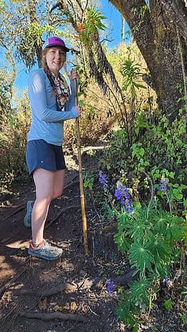
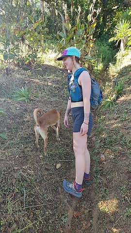
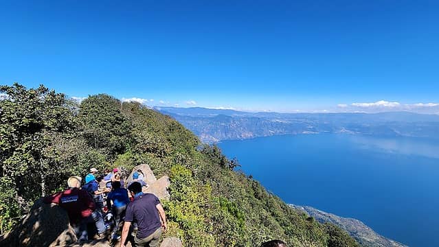
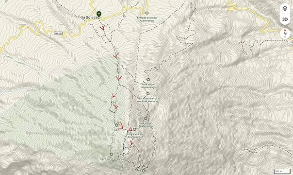
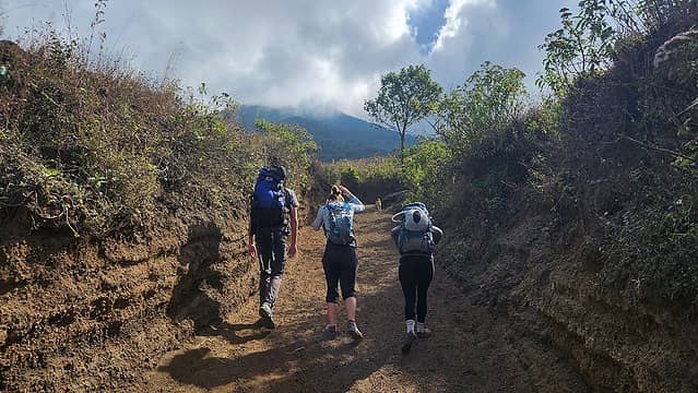
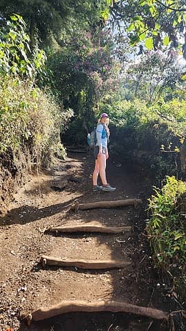
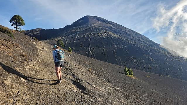
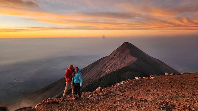
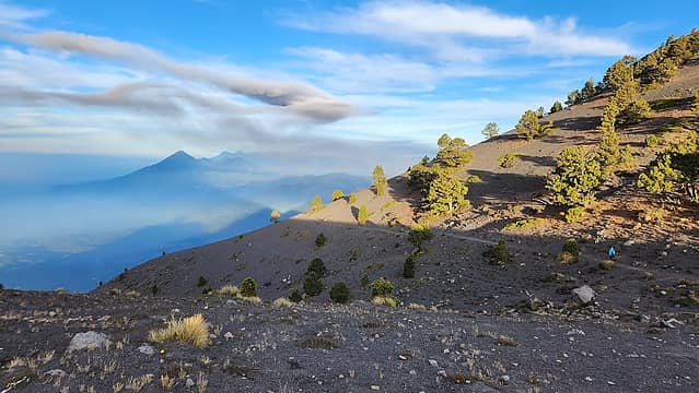
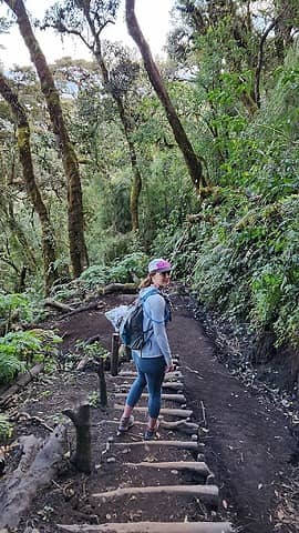
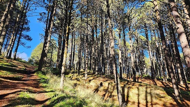
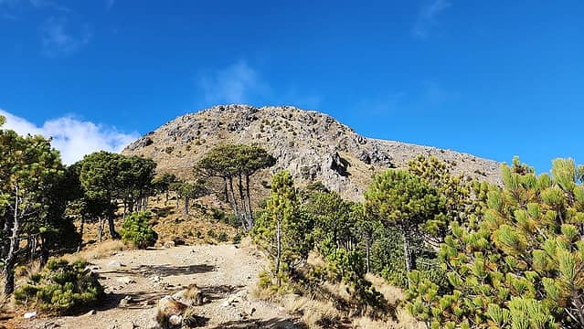
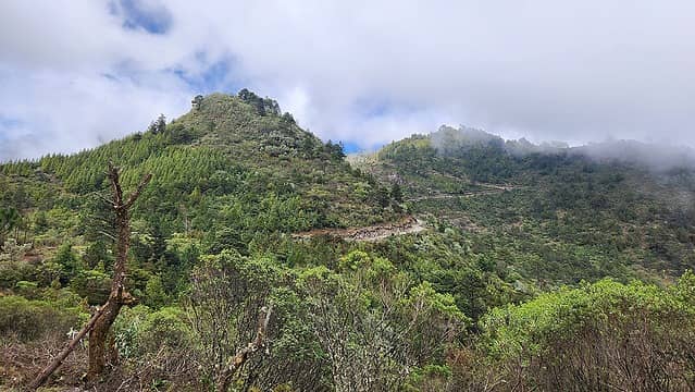
After a very nice New Years break at our quaint AirBB in San Pedro, we made plans with my friends Kelly and Lorin who were driving down the Pan American Highway. We made a short half day hike up the Indian Nose at the far west end of Lake Atitlan on New Years day, then the following day we took the boat across to Panajachel where they were stationed and we all drove out together to the small village of Aldea La Soledad through the towns of Patzicia, and Parramos (where we stopped for a fried chicken lunch break). At about 1pm we arrived at the 2450 meter elevation trailhead and negociated a price of 50 Quetzales to park their van for one night at a nearby parking lot. We were soon packed up and starting up the steep trail for Acatenango Volcano. We quickly passed a small house a few hundred feet up the trail which sold hot sweet treats, drinks and sandwiches but we were in the zone and didn't stop. 15 minutes or so past this a few guys tried to ask us to each pay a fee to hike the trail but between the 4 of us we got them to give up and we continued up without really acknowledging them. Shortly after that we found where those same guys hang out and collect money from everyone. They must only wait until 1pm or so then hike down for the day. Lucky for us they weren't at their post when we passed them which made it easier for them to give up trying to charge us!

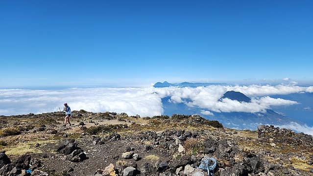
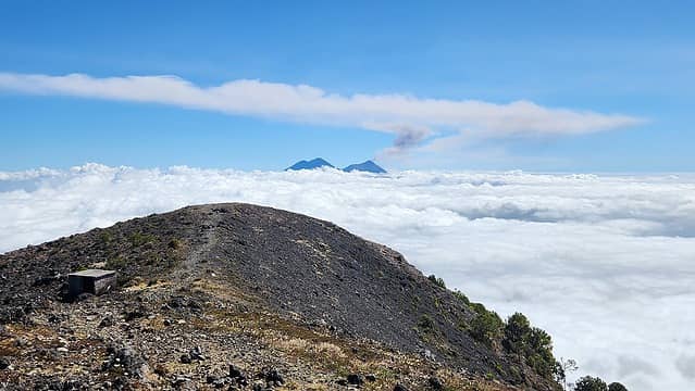
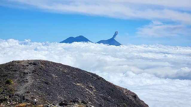
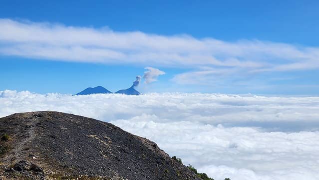
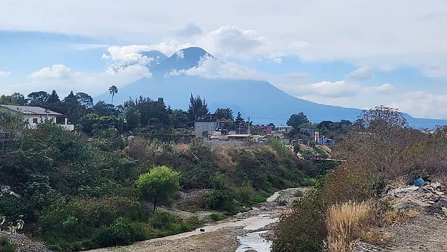
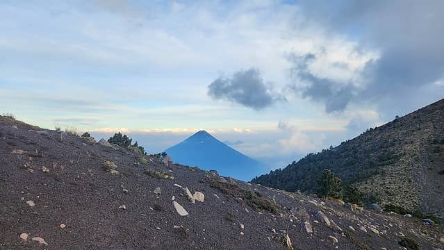
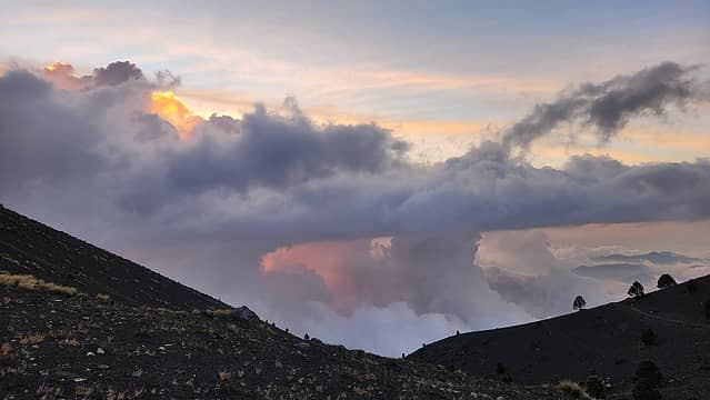
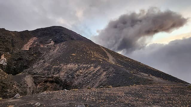
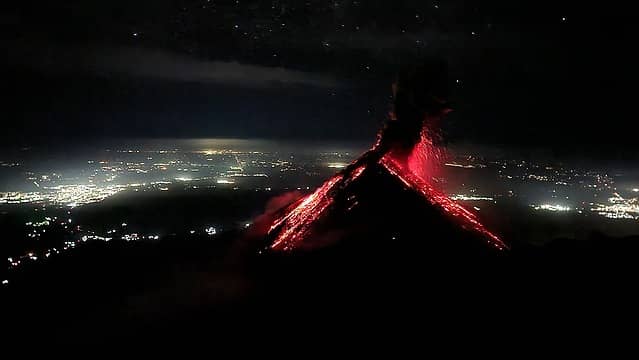
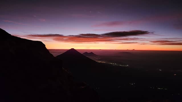
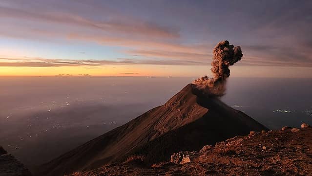
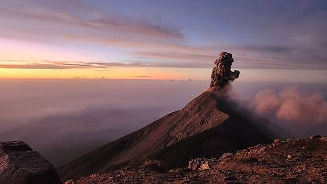
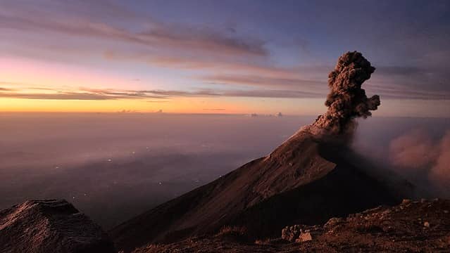
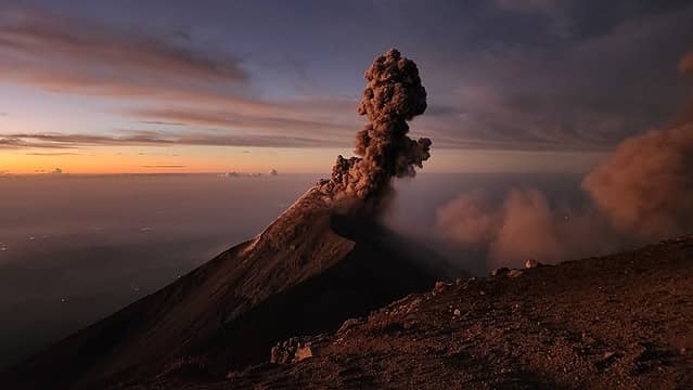
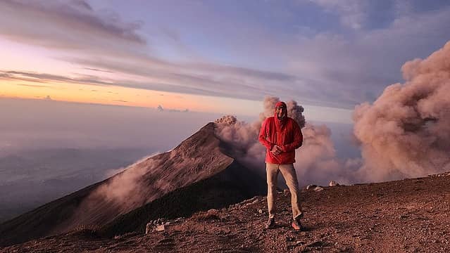
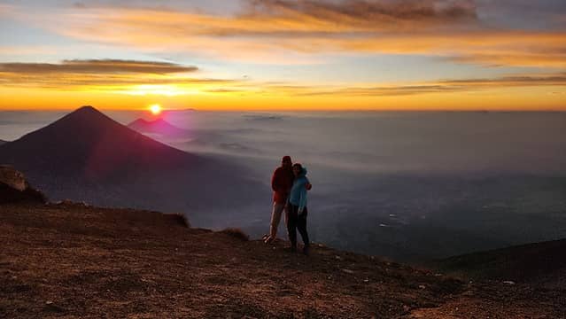
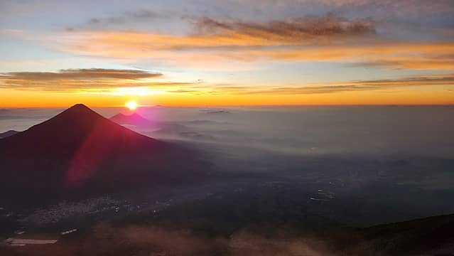
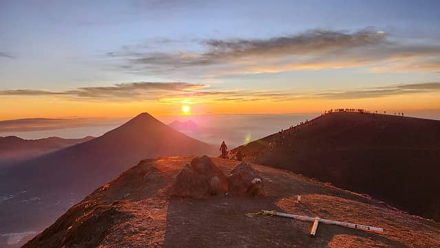
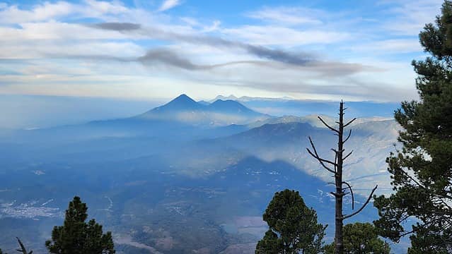
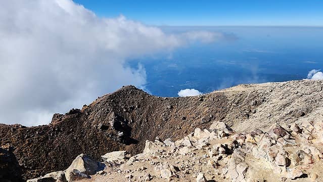
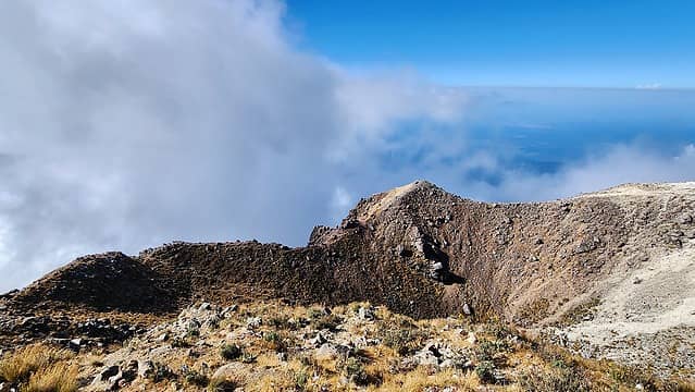
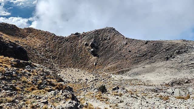
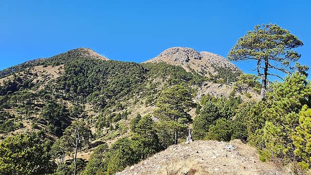
It was a smooth and fairly quick hike up to the broad saddle between the main summit and the lower north summit of the mountain. This saddle is right above treeline and at 3770 meters. It was shortly before 5:00pm when we arrived and we knew it got dark early so we located two excellent flat camp spots in an old crater (a hole essentially) which provided shelter from the wind. As the clouds whipped by in the evening light, it was getting chilly so we quickly put the tents up. Bri and I made the short hike to the top of the north peak to keep the legs going a bit longer and to watch the sunset. It was a spectacular evening. By 6:30pm it was dark and we were in the tent with alarms set for 3am. We wanted to finish the hike up to the top of Acatenango with a couple hours left of darkness to see the erupting lava glowing in the dark coming out of Fuego Volcano (the next mountain just a few miles to the south). Fuego erupted very violently in 2018 in a large eruption that is well documented on video. Some small villages to the south of the mountain were destroyed, but the mountain has remained active ever since, billowing up small plumes and spurts of lava every 30 minutes or so. We would then watch the sunrise before we started hiking down. At 3:30am we managed to get out of the tent and start hiking up the path the final 800 feet to the summit. I had recommended we all bring our sleeping bags so we can sit more comfortably at the top since it was certainly going to be breezy and about 40 degrees out. We got to the top and right as we arrived, a huge spurt of red glowing lava shot up from Fuego which immediately got our attention and our minds away from the cold. We nestled down next to a rock to break the winds coming from the east and huddled up in our sleeping bags and got the cameras ready. About 25 minutes after the first billow of lava another one came out. This was such a sight to see, and was something that has been on my bucket list for as long as I could remember.

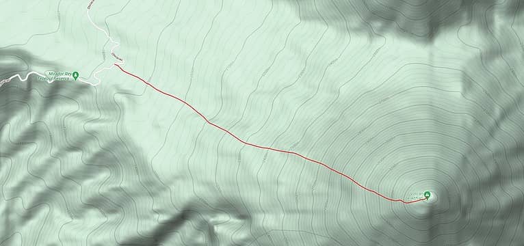
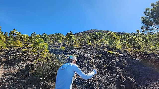
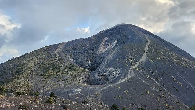
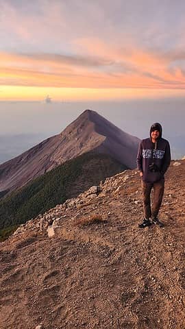
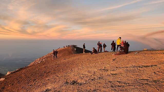
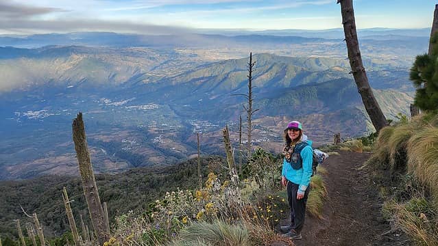
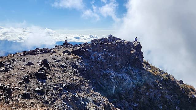
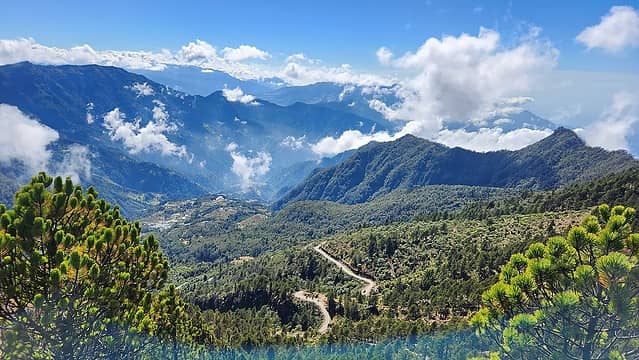
Seeing an active volcano just always was so fascinating to me. We got to experience total darkness at the top for about 2 hours, where we got to see 4-5 plumes of lava, some of which we managed to get decent photos of. The lights from all the surrounding villages far below us also added to the ambiance of the experience. We also amazingly also had the summit to ourselves most of the time, but as twilight began to start, more people seemed to just appear out of nowhere. We did not really notice truly how many people arrived until we decided to try and warm up a bit about 15 minutes before sunrise and emerged from our sheltered spot and looked behind us at which point I realized there had been well over 100 people arrive at the summit to watch the sunrise. Most of these people were in guided groups, which we were again thankful that we came up independentely. There are few things worse than guided group excursions! Almost immediately after the sun rose we ran over to the highest point around the summit crater of Acatenango (which was on the north end) and began quickly running down the scree slopes back to the tents. I noticed people were descending in all different directions which indicated there were many trails and many different camping areas people use. We made quick work packing up the tent and made a very leisurly walk down back to Kelly and Lorins van. Bri and I decided it would be easiest if they took us to Antigua where we could hop on a chicken bus more easily since they were continuing eastward. We had to get back to San Pedro. Luckily there was a large bus station in Antigua and we got on the next bus to Chimaltenango, at which point we got on another bus than sped westward on the PanAmerican highway to Los Encuentros. Next, the bus conductors (the kids whocollect the money) were very helpful and shuffled us onto a bus that was heading south to Soloa (the town right above Panajachel). From there a nice local offered us a free ride down the steep road to the boat dock and we were quickly on the next boat across the lake to San Pedro. We made it back to our AirBB well before dark and had time to share our experience with our host who was incredibly impressed we managed to hike to the top of Acatenango without paying a dime in fees. We enjoyed a nice home cooked dinner as I was preparing to leave the following day for my work obligations in Huehuetenango. The photos below are from our experience on Acatenango, one that I surely will never forget. The first photo shows the route we took up the mountain. There are many trails but this one offered us the most efficient route to the saddle to camp.

Map of our route with the red arrows
Boating across Lake Atitlan to Panajachel
Small villages on Lake Atitlan
Atitlan Volcano from the highway
Lake Atitlan below from highway
Starting up the trail to Acatenango
 
Informative signs about the flora
A plume of ash coming from Fuego
Informative sign about the geology (it was not 100% correct lol)
Taking a break in the afternoon light
 
Hiking towards the ash plume
Nearing the broad saddle at treeline
Acatenango summit 800 feet above the saddle
Volcan del Agua off to the east
Acatenango summit from the north peak
Clouds off to the west and north
Views from the north peak
Acatenango from the slopes of the north peak
Volcan del Agua
Volcan del Agua
 
At the saddle
At the saddle
Sunset glow in the clouds
 
 
The best photo I got of the glowing lava at night around 5am
Twilight begins to the east
Volcan Fuego
Volcan Fuego
 
Fuego burping just to the south
 
 
Volcan del Agua with twilight glow


Bri and I atop Acatenango
 
Other people coming out of the woodworks at the top
Acatenango casts a shadow at sunrise
 
Sunrise from the true summit of Acatenango at the north side of the crater
 
 
Sunrise as we begin walking down
Acatenango shadow
Acatenango shadow
North peak
North peak
We hiked that one a few days prior!
Back at the saddle
Back at the saddle
Atitlan Volcano
Atitlan Volcano
 
Tajumulco (my next objective) way off in the distance
 
 
Indian Head (which we also hiked) from the boat back to San Pedro


The full album of photos can be seen here.

My pre-arranged ride picked me up directly from our AirBB in San Pedro the following afternoon to take me to Huehuetenango and I said my goodbyes to Bri, who would hang around another couple days before she would get a ride back to the Guatemala city airport and fly back home to Bozeman. We would soon meet again though in only a week and a half time in Chile however! After working at a now inactive mine for 6 days about a 90 minute drive northwest of the city of Huehuetenango, I was back in Huehuetenango and had a couple more days before my flight to Santiago. I really wanted to hike Tajumulco volcano, since it was close to where I was on the western end of Guatemala, and it is also the highest peak in all of central America. I managed to find the correct chicken bus at the main bus depot in Huehuetenango with the help of some locals roaming around. I kept asking which bus would get me to Tajumulco, but I realized that asking for the direct bus to San Marcos was easier. The correct bus takes the route through Sipacapa and Tejutla before going through the small village of San Sebastian then turning southeast to San Marcos.

I got off in San Sebastian though and managed to find a place to grab some food at a gas station. I had done quite a bit of reading about this area of Guatemala being unsafe as it is right in the crossroads of major growing fields for two large mexican cartels. I saw a heavy police presance but they seemed to be doing a decent job of keeping the peace. Just 6 month prior to my visit the area was a warzone. I hopped on the next chicken bus I saw heading west on highway 12N towards Tacana near the Mexican border. O only rode for a few minutes though and got off at the Hotel Villa Real a few hundred yards from the top of the mountain pass. The village of Tajumulco was just a few minute more drive from the pass west down the other side but I did not need to go there. A knocked on the door of the Hotel Villa Real which was a somewhat rundown place with way more rooms than ever would be utilized, but no one answered. Google reviews of this exact area spoke of a nice resturant called Resturante Puerta al Volcan that was supposedly directly across the street. After walking around a few minutes I found it up a small road and above the highway tucked away. No one was there, but the ladies inside were excited and served me up an awesome steak meal. The old man who owns the hotel was walking down the path as I walked up and greeted me. He said he will be waiting at the door after I finish eating. I walked back to the hotel across the street, and he charged me just 70 Quetzales (about $10) for a night stay. Granted the hot water did not work, it smelled like mold and most of the lights didn't work, I could see this was once a nice place. The tile work was very well done and the exterior walls nicely finished. There was no heat though so he gave me a stack of blankets. He did not understand or speak one bit of english, and seemed to enjoy just rambling on to me in some form of spanish I couldn't understand. Either way, it was a bed and a roof over my head for the night, which it rained quite a bit. I set my alarm for 5am to get up and start hiking up the trail.

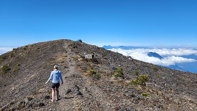
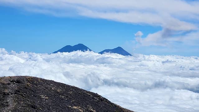
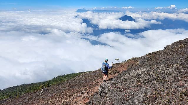
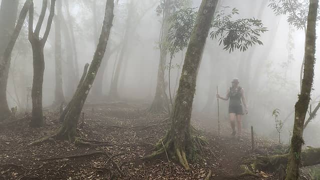
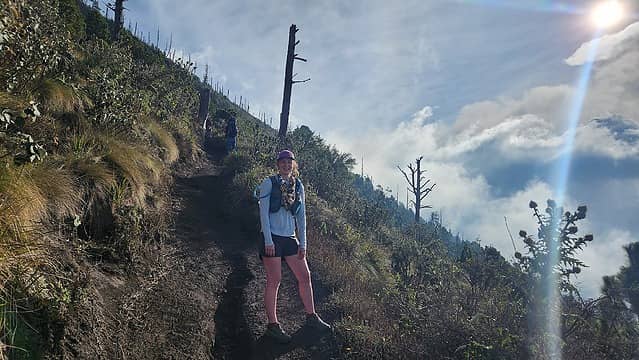
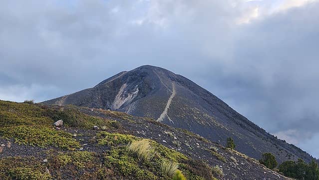
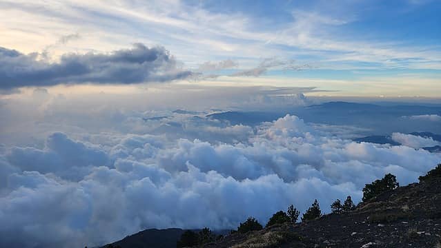
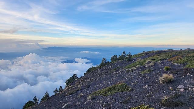
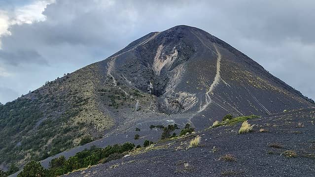
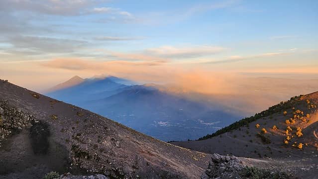
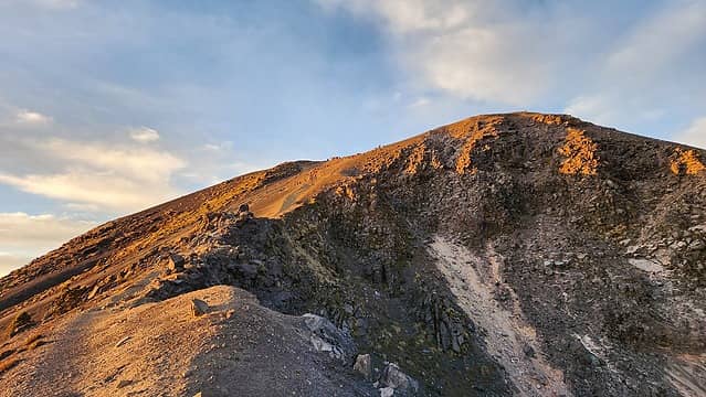
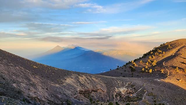
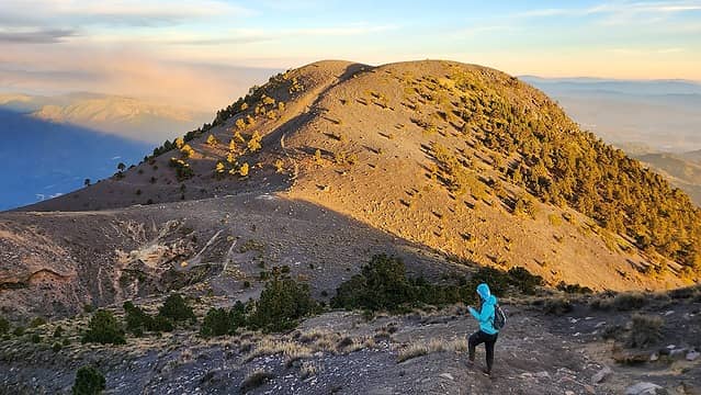
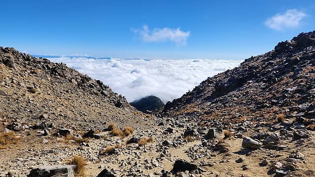
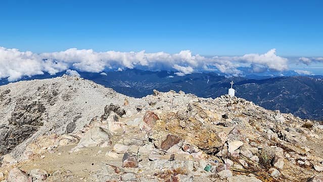
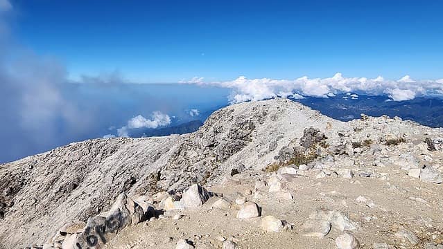
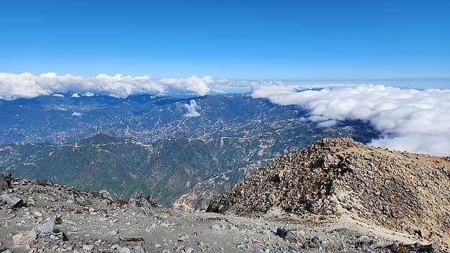
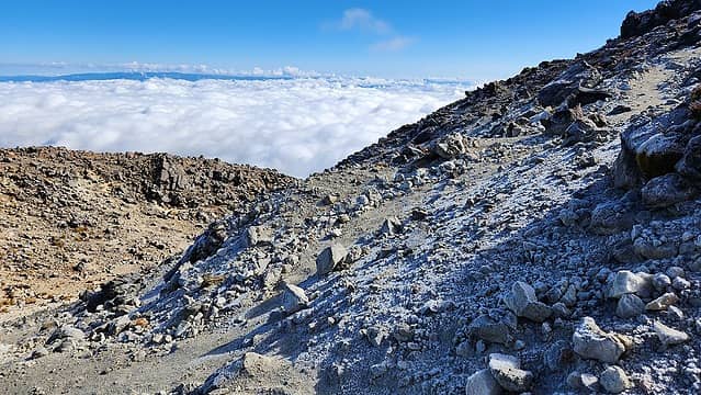
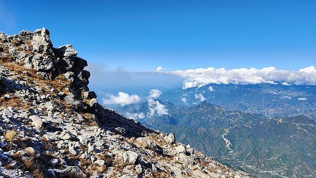
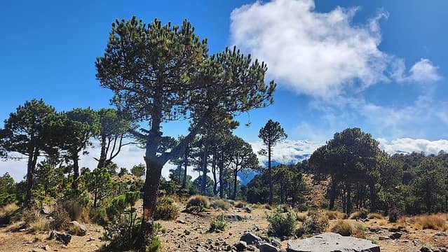
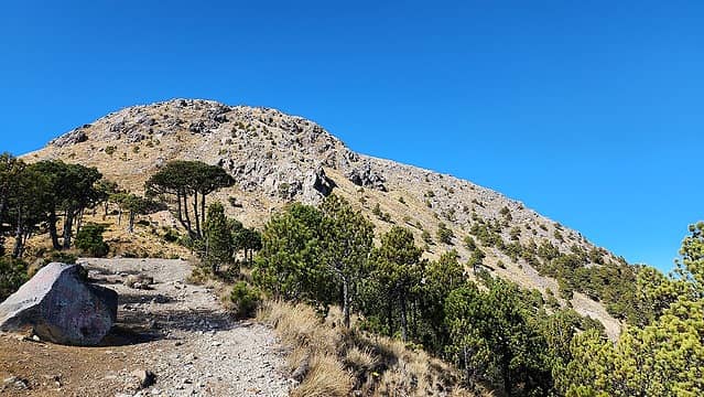
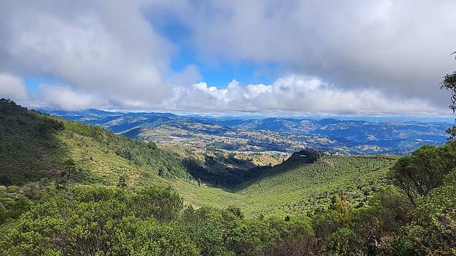
5am came, and it was intensely foggy. I could barely see across the street so I decided to give it another hour. 6am and some light was starting to illuminate the clouds but it was still foggy. By 7:30am it was go or go home. I figured after thinking to myself for 20 minutes I may never get a chance to be in this place ever again so I decided to start walking up the trail (which began directly across the street from the hotel). I hoped I would hike above the clouds and they were just hovering down in the lower altitudes. The trailhead at the mountain pass was at an elevation of 3020 meters. The initial part of the walk followed a steep 4WD road which continued well beyond what I had expected. I was not feeling super speedy this morning, and the fog gave me a bone chill especially on my exposed hands since I didn't have gloves. I slowly made my way up the switchbacking road in thick fog with water dripping from all the trees. It had also rained the previous night so the ground was muddy and slick. I just kept hoping I'd break through the clouds at some point. Shockingly, the 4WD track continued all the way to 3550 meters in elevation! With a truck this makes the hike to the 4220 meter summit laughably short for being the highest peak in all of Central America. At the end of the road there was a small parking area, and a flat meadow with a nice trail continuing through the meadow. As I walked through this meadow, I could see the clouds thinning above me, and just as quickly as they thinned, I was above them! I was elated and a burst of energy allowed me to hike substantially faster. I caught up to a local who had passed me on the road below while I was taking a break, and passed him. The trail reached a ridge crest (the east ridge of the mountain) at 3740 meters and continued up the scenic ridge as the trees began to thin out. At the surprisingly high elevation of 4000 meters I finally made it above treeline and the final 200 meters were a steeper class 2+ scramble on stable rocks. The upper park of the mountain was littered with little Virgin Mary statues, typical of Latin American culture. I made it to the summit after passing a couple large groups of high school aged kids (good for them!) and enjoyed the views in all directions as the clouds gently whiffed in the light breeze. I was not able to see any of the other volcanoes off to the east due to lower cloud layers, but nonetheless, I had a clear view. The summit was a very large area and the crater was filled with words people had spelled out with rocks in spanish. This is apparently a popular place for locals even more so than foreigners.

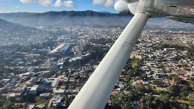
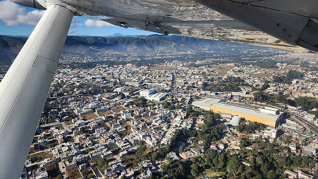
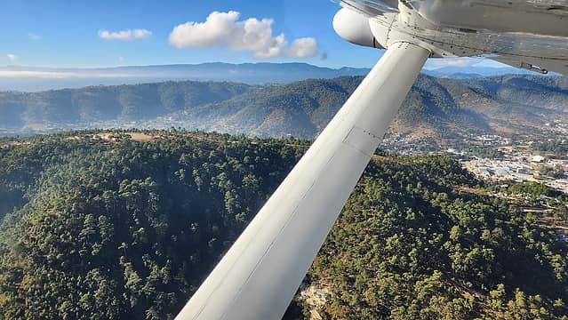
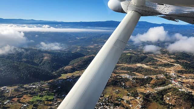
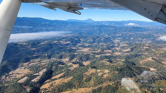
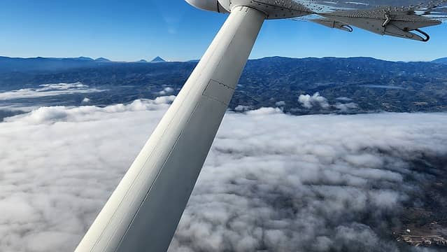
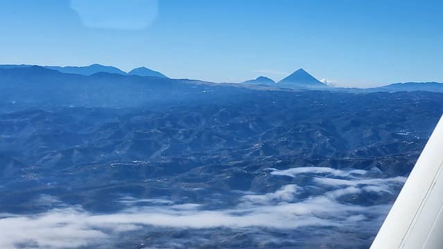
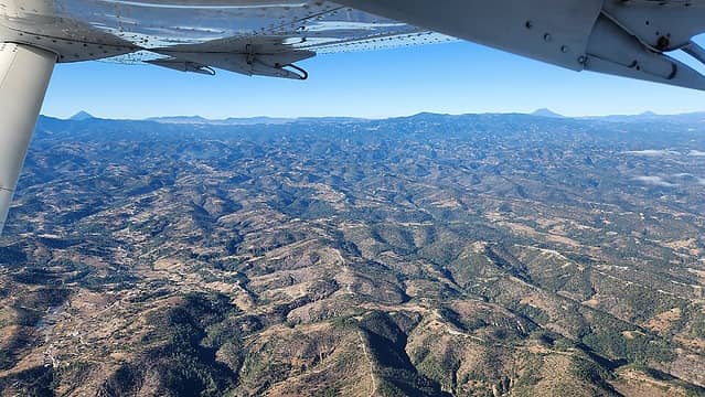
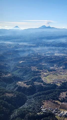
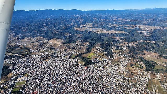
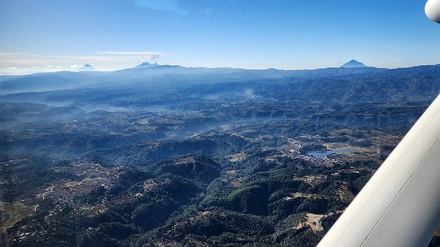
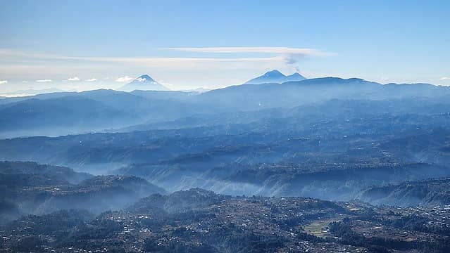
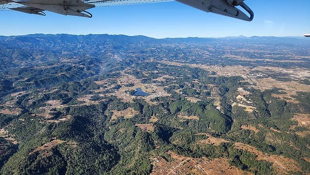
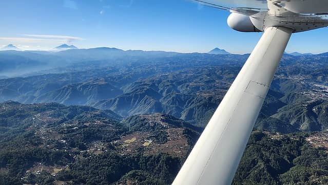
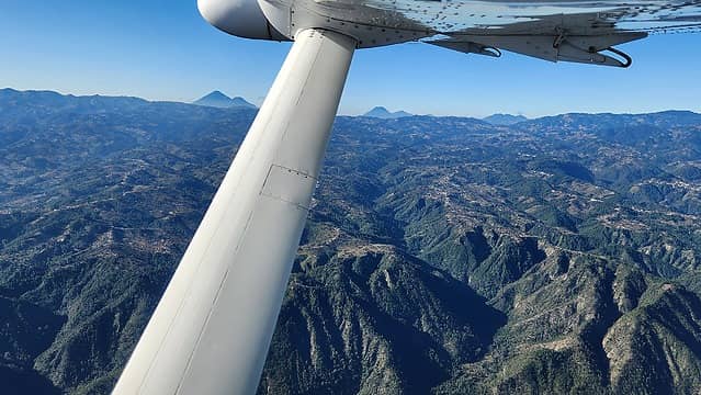
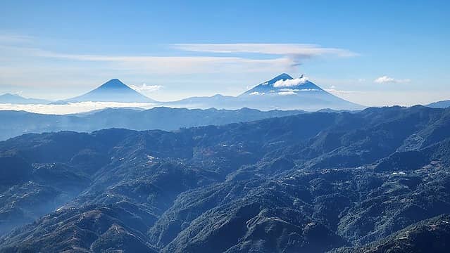
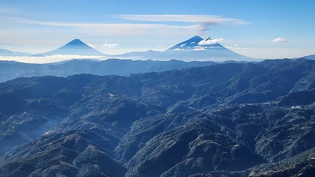
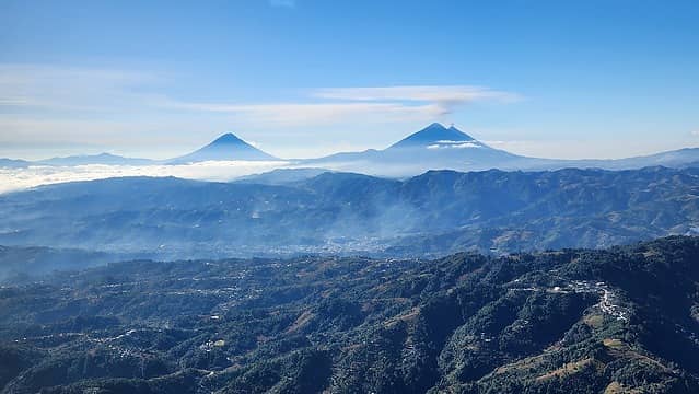
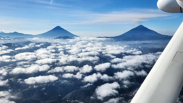
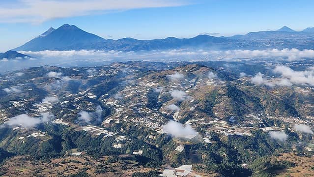
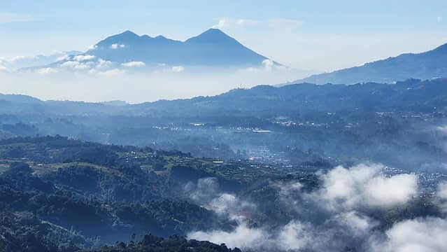
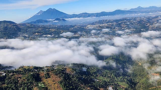
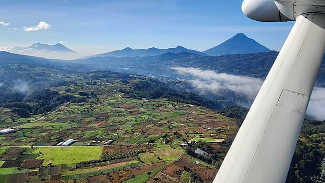
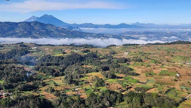
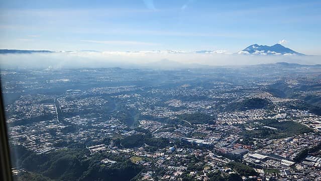
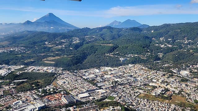
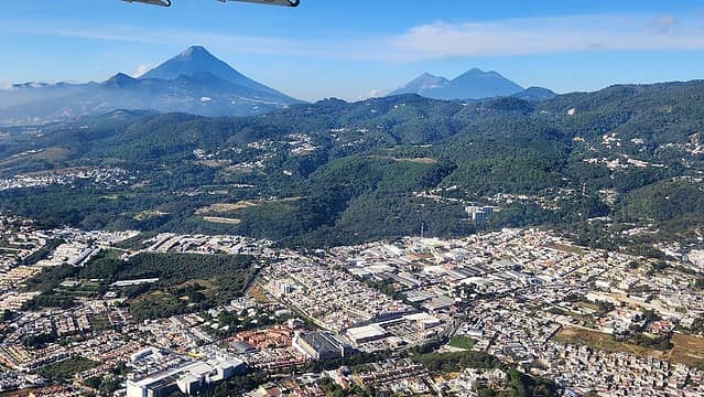
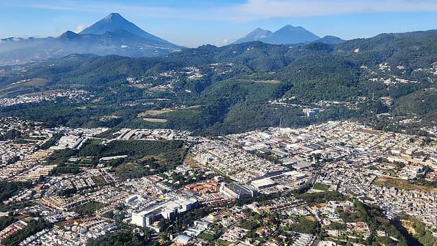
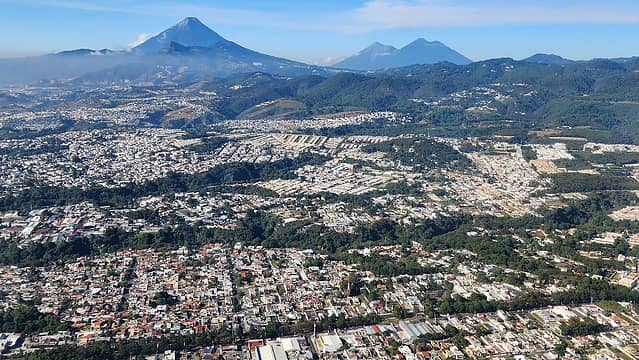
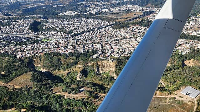
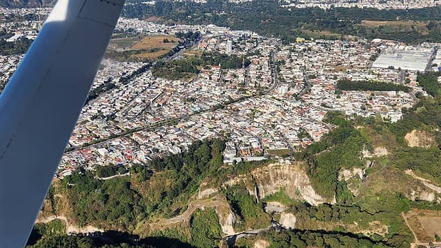
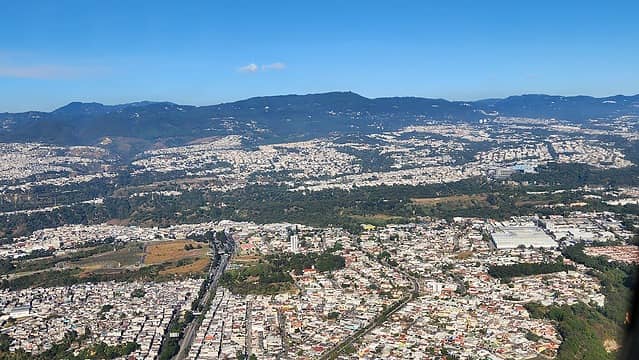
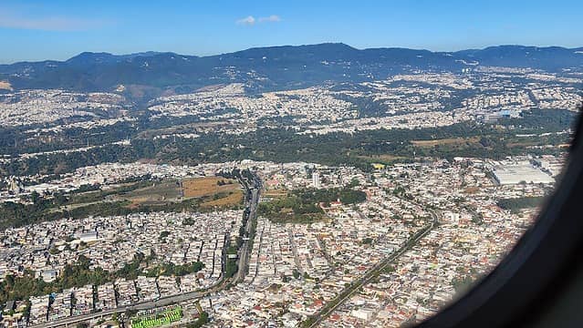
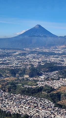
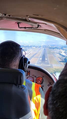
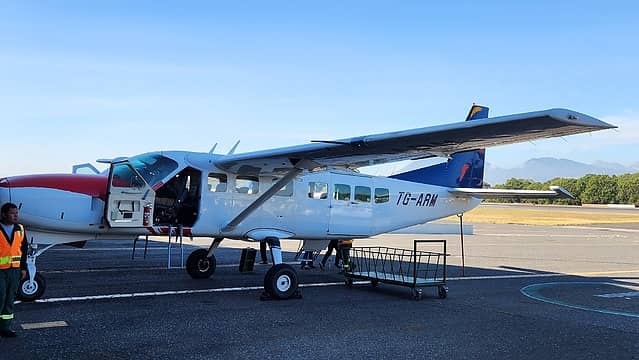
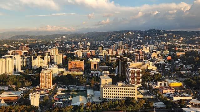
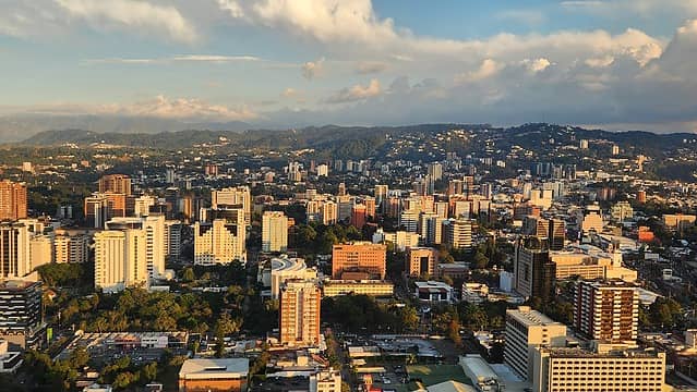
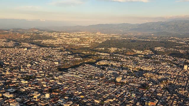
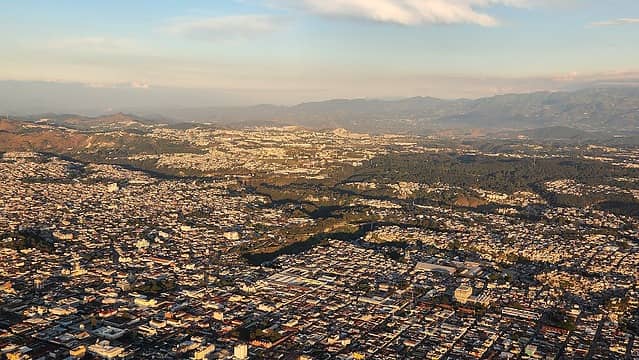
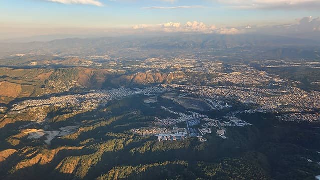
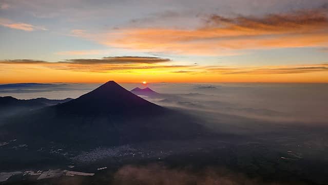
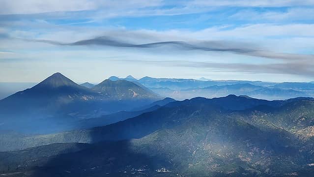
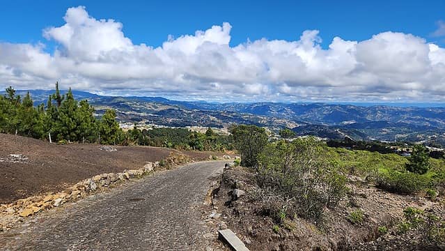
After a 30 minute summit stay, I made quick work of the hike down. I ended up descending down the whole east ridge instead of taking the trail back to the pass so I could directly hike to San Sebastian to directly catch the bus back to Huehuetenango without having to take another short bus ride. There is a good road that ascents high up onto the SE slope of the mountain reaching an elevation of 3540 meters before descending all the way down to 2100 meters elevation way down the SE flank of Tajumulco and just dead ends there! Crazy I thought, but this road connects San Sebastian with remote farms down there. I continued down along the ridgecrest, following a small trail until I ended up traversing to the right and bushwhacking down a little bit to meet the road close to where it crosses the east ridge of the mountain near a small gap at roughly 3500 meters. I then walked the road all the way back to the town of San Sebastian and waited for the next chicken bus back to Huehuetenango. I did not have to wait long thankfully, as the next one came at noon only 20 minutes after I got the the crucero. By 3:30pm I was back at my hotel and had another nice dinner at the resturant. As a bonus treat, my client provided a private flight back to Guatemala City from the tiny Huehuetenango airport which offered me a unique experience to see all the Guatemalan volcanoes and the landscape from the air! This small 8 seater plane was perfect for getting some low altitude aerial vantages of a huge part of the country, and of the mountains I hiked during the trip. The photos below are of my hike up Tajumulco.

Entering the flat meadow just before breaking above the clouds
First views
First views
Hiking on the east ridge
Nearing treeline
Nearing treeline
First look towards the summit
 
 
Nearing the summit
Nearing the summit
Final slopes to the summit to the left
Summit view
Summit view
A look into the crater
 
A tiny bit of frost on north facing slopes just below summit
 
 
Hiking back down the east ridge
 
Super cool trees
Super cool trees
 
 
The road I was aiming for
 
Walking down the road
 
 
Back below the clouds walking past quiet farms
 
Near San Sebastian
Near San Sebastian

The following photos are one I took from the sweet flight from Huehuetenango to Guatemala City. The last few were sunset photos taken from the commercial jet I was on when I flew out of the country later that evening. Overall it was a very cool trip to Guatemala, which is a place I may not have ever travelled to if it weren't for the work project that sent me there (and covered the flights!)

Huehuetenango
Huehuetenango
Huehuetenango
Huehuetenango
 
 
Acatenango and Volcan del Agua


Closing in on Guatemala City
Proudly powered by Weebly